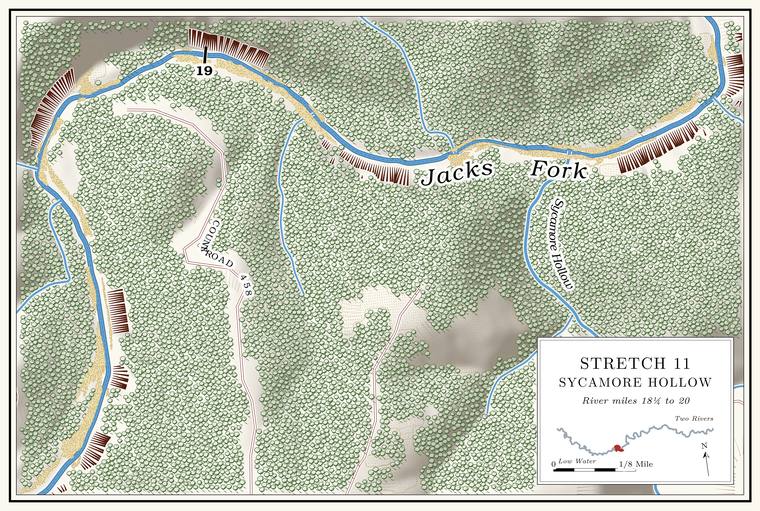
The Lodder holes, Lodder Bluff and Lodder Ford
Pools, bluff and ford · left bank (bluff) · about miles 18.3 to 19.5
Below Dark Hollow come three Hole. Any pool deep enough to swim or fish in, named or not, the basic unit of the river in local speech; also “hole of water” (Chapter 18). Glossary → known as Upper, Middle and Lower Lodder Hole, flanked by a long, high Bluff. A cliff along the river, usually on the outside of a bend, where the river has cut sideways into the hill. In this sense the word was first used in North America (Chapter 2; Chapter 18). Glossary → on the left that begins below the upper hole, a separate bluff from Low Gap Bluff above Dark HollowLewis 1980, PDF p. 35 (the curve around Low Gap Bluff, then Dark Hollow, then “A long bluff starts on the north side of the river below the Upper Lodder Hole”) and the maps on PDF pp. 33, 37; on the river centerline the two bluffs stand on the outsides of separate bends, and at the turn at Dark Hollow (about miles 17.8 to 18.3) the left bank is the inside of the bend.. The names are said to come from a Lodder family who lived nearby, though who they were has not been tracedsee Chapter 8. (Chapter 8). By one account the holes had filled in by 1980 compared with earlier years. A dripping bluff is said to flank the middle hole, and a small spring comes in on each side of the river below the Ford. A place where a road crosses through the water. Many of the river’s fords took the names of the families who lived beside them (Chapter 8). Glossary →. Lodder Ford, by the bluff, is said to be a favorite spot for huntersLewis 1980, PDF pp. 34–35, the only source; on the left: Lewis 1980, PDF p. 35 (“on the north side of the river”) and PDF p. 37 (map)..
The bluff rises about 340 feet above the water, one of the tallest faces on the rivermeasured on the flood-mapping terrain (Heimann, Atkinson and High 2025; Map 13), the faces on the left at about miles 18.7 to 18.8 (about 330 feet) and 19.0 to 19.1 (about 340); the floaters of 2007 read more than 300 feet from the federal topographic map (Johnson 2007, 20, 31).. Floaters in April 2007 found an abandoned side channel at its base, left when the river moved southJohnson 2007, 20, 31., away from the foot of the rock. The places the angler marked on a map set the middle hole about mile 18.7 and the lower hole about 19.2, and put the ford at the end of the bluff by the mouth of Sycamore HollowJacks Fork Oral History, record SV-23 (places marked on a map, laid against the river centerline).. A woman who knew the upper river as a child in the 1920s remembered Loader Ford and Catfish Bluff for their deep holes, “and that’s where people fished a lot” (Chapters 18 and 19).
Sycamore Hollow and Sycamore Hole
Hollow and pool · right bank · about mile 19.6 · Plate A7
Sycamore Hollow comes in from the south, draining nearly three square milesJacks Fork Creek Network 2026 (2.9 square miles); USGS GNIS (727414)., and the Pool. A deep, slow stretch of river between riffles (Chapter 16). Glossary → at its mouth is known as Sycamore Hole. A good springLewis 1980, PDF p. 34, the only source. is said to run water into it. To the angler, who knows the hollow, it has changedJacks Fork Oral History, record SV-23..