Where Highway 17 crosses the Jacks Fork north of Mountain View, the Park Service sign reads Buck Hollow. Asked in 2026 what they call the place, twelve peopleJacks Fork Oral History, records SV-03, SV-05, SV-06, SV-09, SV-12, SV-15, SV-19, SV-20, SV-22, SV-23, SV-24, SV-25. who know the river gave seven different answers. Most who grew up in Mountain View said Steel Bridge. Someone who grew up in Eminence said 17 Bridge Hole. A Birch Tree resident and an Eminence resident who has done park and conservation work said Buck Hollow. Others said Highway 17, or gave two names at once: “Buck hollow or steel bridge,” “17 Bridge/Buck hollow,” or “Buck hollow or it used to be referred to as the Steel Bridge.”
Every place on the river carries two kinds of names. One kind is printed, on topographic maps, in the federal names file, on Park Service signsee Reach D.s and in float guides. The other is spoken and passes from parents, grandparents, neighbors and friends. When the same people were asked who taught them the names of places on the river, they named grandparents, parents, an uncle, a husband, fathers-in-law, neighbors, friends and “new acquaintances.” One of the ten who answered mentioned maps. Most of the Hole. Any pool deep enough to swim or fish in, named or not, the basic unit of the river in local speech; also “hole of water” (Chapter 18). Glossary →, bars and Shoal. A fast, shallow, rocky stretch between pools; a riffle. Suckers crowd onto the shoals in spring, and the old saying is that “the dogwoods bloom when the suckers are shoaling” (Chapter 18; Chapter 19). Glossary → of the river have only the spoken kindUSGS GNIS; O’Brien 1939, dictionary, passim.. (Who Jack wassee Chapter 4., and how the river got its own name, is in Chapter 4.)
Two sets of names
The official names of American places are settled by the U.S. Board on Geographic Names, a federal board set up in 1890 so that every government map and document would call a place by the same name. The names it approves are kept in the Geographic Names Information System, which the U.S. Geological Survey maintains, and the names on federal maps are drawn from it. A state board recommendsgeneral (the board dates from 1890); BGN 2016 sets out its policies and procedures. changes for its own state, and the federal board decides. Officially the Jacks Fork watershed has 40 named streams and 92 named valleys. A few Pool. A deep, slow stretch of river between riffles (Chapter 16). Glossary → have official names, Baptizing Hole and Muck Forty HoleUSGS GNIS, Domestic Names file for Missouri, matched to the watershed in Jacks Fork Creek Network 2026. among them, and most of the places where people swim and fish have none.
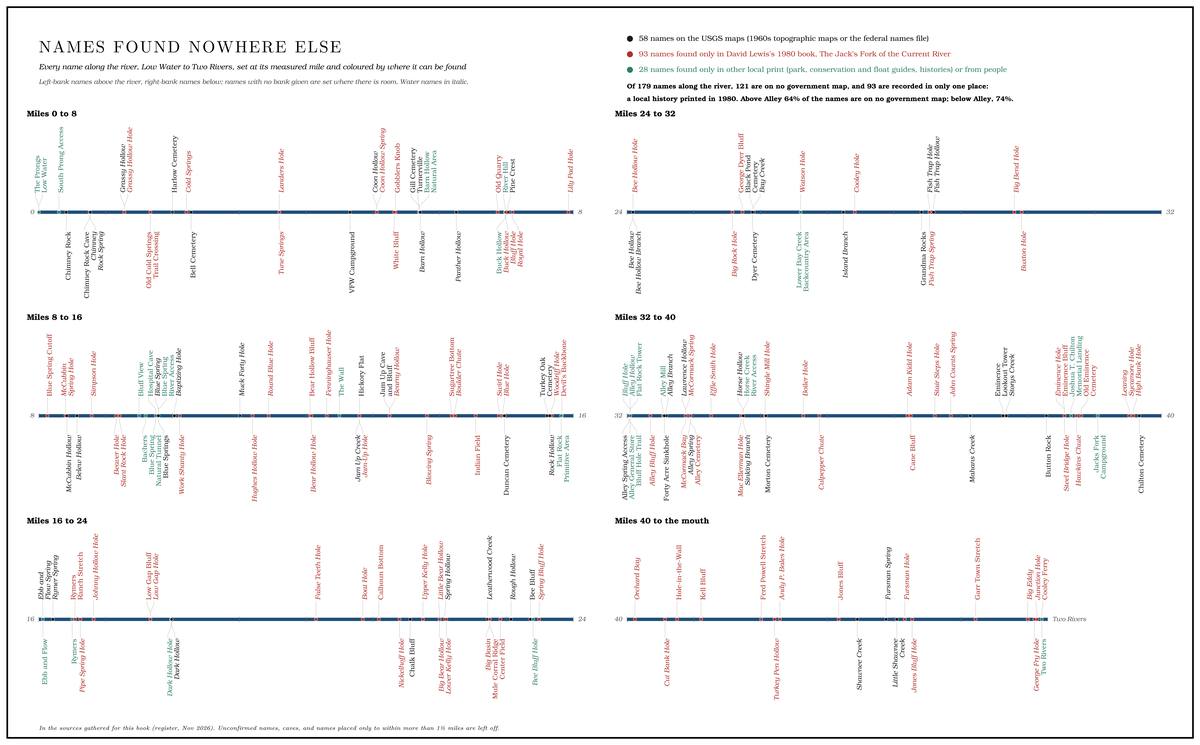
The oldest written dictionary of the region’s names has the same gap. Missouri was the first state to take up a systematic study of its place names, begun at the University of Missouri in 1928, and by 1939 eleven graduate theses had worked through 82 of its counties. The twelfthO’Brien 1939, iv (about 17,000 names; the work begun under Allen Walker Read and continued under Robert L. Ramsay). was finished that year by Anna O’Brien, a graduate student who took on five south-central Missouri counties, Shannon and Texas among them. She copied every name she could find in county histories, postal guides, atlases and highway maps onto its own slip of paper, then went into the counties and asked peopleO’Brien 1939, iii, vii, 1. where each name came from. Shannon County was hard country for that work. It had only a Branch. A small creek. The sense is American, on record from 1674 (Chapter 18). Glossary → railroad across its southern edge, and Eminence, she noted, could not be reached by any common carrier, though a ride might be arranged with the bread-truck driver or the rural mail carrierO’Brien 1939, v.. She took over the family car, and her professor spent what she called “a sort of busman’s holiday”O’Brien 1939, ix–x (the professor is Robert L. Ramsay). gathering names in Shannon County himself. In Shannon and Dent counties the lumber and mining camps, some lasting only a few months before they moved on with the receding forest, had left names that she thought had doubtless been missedO’Brien 1939, vi–vii (“Many of these names have doubtless been missed”).. In 1945 Cora Ann Pottenger did the same for Howell County, which takes in Mountain View and the head of the South Prong country. Between them they recorded the origins of many of the creeks, hollows, schools and post officesPottenger 1945; O’Brien 1939, dictionary, passim. around the Jacks Fork. Apart from Chimney Rock, Jam-Up Hollow, Hospital Cave and the names around AlleyO’Brien 1939, dictionary, passim., the river’s holes, bars, Ford. A place where a road crosses through the water. Many of the river’s fords took the names of the families who lived beside them (Chapter 8). Glossary → and shoals are absent.
Where the stories came from matters too. In Shannon County the people who explained the names were a merchant, the postmaster, a state senator, county judges, schoolteachers, an abstractor and a ninety-year-old prosecuting attorney, nearly all of them in Eminence. Of the eight who explained the Texas County names, four lived in Houston and Summersville and one in ArrollO’Brien 1939, bibliography, iii–vi (informant list).. The stories that got written down are largely the county seats’ versions.
How the old names were made
The origin stories are what people said in the 1930s and 1940s, and the doubtful ones were marked as doubtful when they were written down. In the 1939 dictionary one asterisk flags a story open to reasonable doubt, and twoO’Brien 1939, 1 (two asterisks mark a name unsolved, one a name in reasonable doubt, and R one that Ramsay helped solve). flag a name nobody could explain.
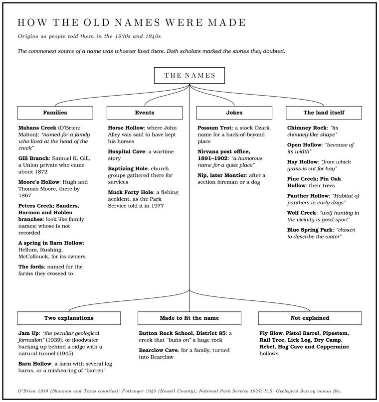
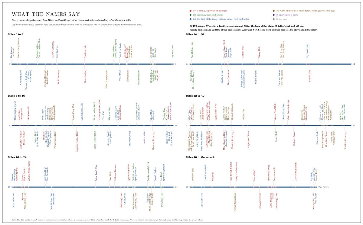
Families. The commonest source of a name was whoever lived there. Mahans Creek, spelled Mahon in 1939, was “named for a family who lived at the head of the creek.” By another account it was named for William Mahan, a son of James and Jane Mahan, who settled by the spring below Bohannon or Pummill HollowLewis 1980, PDF pp. 54 (“Bohaman or Pummill Hollow”), 61 (“Bohannon or Pummill Hollow”); see Reach I.. Gill Branch, in the Barn Hollow country, carries the name of Samuel K. Gill, a Union private who came about 1872Pottenger 1945, Howell file pp. 22, 40.. Moore’s Hollow, in northern Howell County, was named for Hugh and Thomas Moore, who lived there by 1867Pottenger 1945, Howell file p. 69.. Peters Creek, the largest creek on the North Prong, carries the name of a ranch manager of the 1880s, and the Harmon branchessee Reach A (Lewis 1980). the name of an early family on the Prong. A branch or arm of a creek, set down in 1860 as Southern usage. The North and South Prongs join to form the Jacks Fork (Chapter 18). Glossary → (Reach A). The fordssee Chapter 8. took the names of the farms they crossed to (Chapter 8).
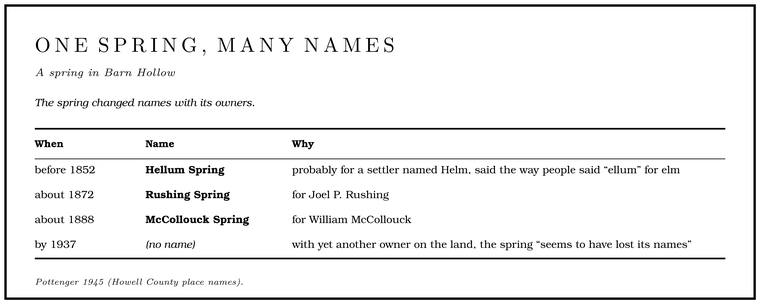
A spring in Barn Hollow changed names with its owners. Before 1852 it was HellumPottenger 1945, Howell file p. 46; see Chapter 5. Spring, probably for a settler named Helm, said the way people said “ellum” for elm (Chapter 5). About 1872 it became Rushing Spring, for Joel P. Rushing, and about 1888 McCollouck Spring, for William McCollouck. By 1937, with yet another owner on the land, the spring “seems to have lost its names.” Spout Spring, on the South Prong side, went partly by the name of the owner who piped its water up the hillsee Reach B (Pottenger 1945, Howell file p. 99). to his house (Reach B).
Events. Some names remember something that happened. Horse Hollow, near Alley, is where John Alley was said to have kept his horses, and Hospital Cavesee Chapters 6 and 13.’s name rests on a wartime story (Chapters 6 and 13). The pool near Blue Spring where church groups gathered for services is Baptizing HoleNPS 1977, Jacks Fork stop 2; see Chapter 19. (Chapter 19).
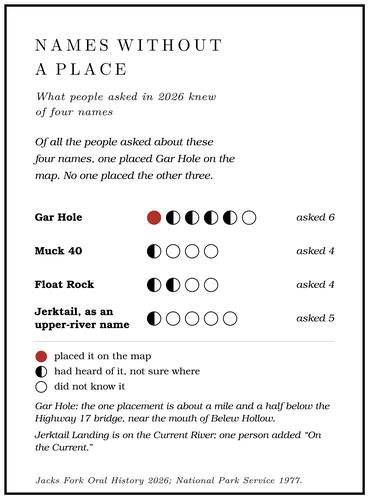
The event most often retold is a fishing accident. As a Park Service folder told it to floaters in 1977, Ozarkers say that John “Muck” Reece, or Reese, of a family that lived near Blue Spring for many yearsLewis 1980, PDF p. 27., and some friends were out one night Gig, gigging. A gig is a spear of three or four barbed iron tines on a pole as much as fourteen feet long. Gigging is spearing fish with it from a boat in clear, shallow water, chiefly suckers, by night under lights or by day (Chapter 19). Glossary → for yellow suckers by the light of Pine knot. The base of a pine limb where it grows into the trunk, so full of resin that it outlasts the rest of a dead tree and burns hot and bright. Pine knots lit the gigging boats, burning in a fire box or metal basket called a firejack in the middle of the boat (Chapter 19). Glossary →, burning on a bed of clay mud in the middle of their Johnboat. A long, narrow, flat-bottomed, square-ended boat, poled, paddled or motored. It was the guide boat of the Eminence outfitters and is still the fishing and gigging boat of the river. The word is in print from 1894 (Chapter 9; Chapter 18). Glossary →. As Muck struck for a fish he lost his footing and fell overboard. When he finally came up, sputtering, he claimed he had sunk Forty. Forty acres, a quarter of a quarter section. A hill farm was often one or two forties (Chapter 5). Glossary → “foot,” and his friends teased himNPS 1977, Jacks Fork stop 3. about it for years. The hole a little more than a mile below Blue Spring carries the joke: Muck 40 Hole on the folder, Muck Forty HoleUSGS GNIS; see Reach D. on the federal maps (Reach D). Of four people askedJacks Fork Oral History, records SV-06, SV-12, SV-20, SV-23. about Muck 40 in 2026, three did not know it and one had heard of it without being able to say where it was.
Jokes. Naming could be teasing. Possum Trot, a stock Ozark name for a back-of-beyond place, went on a hollow, a school and part of early Mountain Viewsee Chapter 5 (O’Brien 1939, 108; Pottenger 1945, Howell file p. 15). (Chapter 5), and the federal map has two Possum Trot Hollows in Shannon County, one entering the Jacks Fork from the left between Alley and Eminence and the other in Winona TownshipUSGS GNIS (724782, Alley Spring sheet; 751722, Low Wassie sheet); U.S. Census Bureau, Geocoder (township of each mouth); Jacks Fork Creek Network 2026 (724782 enters from the left). O’Brien 1939, 108 (“A valley in Winona Township”), probably means the second.. A Texas County post office of 1891 to 1902 was called Nirvana, probably as a joking name for a sleepy placeO’Brien 1939, 93 (“probably used here as a humorous name for a quiet place”).. Montier, south of the river, was first called Nip, after either a Section. A square mile of 640 acres, one thirty-sixth of a township. A quarter section is 160 acres (Chapter 5). Glossary → foreman or a dogO’Brien 1939, 86., depending on who told it.
The land itself. Most other names describe the place or what lived there. Across the five counties of the 1939 dictionary, plants gave more names to towns, churches and schools than any other feature of the country, and nearly four in five of the plant names were trees: oak in eighteen names, pine in thirteen and cedar in nineO’Brien 1939, 178 (99 floral names of towns, churches and schools among 362 environmental names, 78 of them from trees).. Chimney RockO’Brien 1939, 27., the pillar on the Bluff. A cliff along the river, usually on the outside of a bend, where the river has cut sideways into the hill. In this sense the word was first used in North America (Chapter 2; Chapter 18). Glossary → a little below the junction of the prongs, was “so named because of its chimney-like shape.” The dictionaries of the 1930s had no record of “chimney” used for a rock, and the use went down as one of 109 AmericanismsO’Brien 1939, viii, 228. gathered from the five counties, words or senses of words that grew up on this side of the Atlantic. The cave below the pinnacle took its name from the rock, and the springO’Brien 1939, 27. that flows from the cave took its name from the cave. Open HollowO’Brien 1939, 97. was “so called because of its width.” Hay HollowO’Brien 1939, 58., near Eminence, was a valley “from which grass is cut for hay.” Pine Creek, on the South Prong, took its name from pines, along its banksO’Brien 1939, 103. in the Texas County account and along the ridgePottenger 1945, Howell file p. 84. in the Howell County one, and Pin Oak HollowO’Brien 1939, 105. from its trees. Sugar Tree Hollow on Leatherwood CreekUSGS GNIS; Jacks Fork Creek Network 2026. and Sugartree Bottom on the middle river use the old country name for the sugar maple. The Bottom. The flat land along a river or creek, built of its deposits and open to its floods. In the 1920s the bottoms near Eminence averaged about a quarter of a mile wide (Chapter 2; Chapter 5). Glossary → was once the home of several large onesLewis 1980, PDF p. 30 (“once the home of several large sugar maples”), where it is spelled Sugar Tree Bottom; PDF p. 31 spells it Sugartree; see Reach E., and a Shannon County school of the 1930s, Sugar Tree GroveO’Brien 1939, 130 (a Dent County school of the same name was “Named for a maple sugar tree grove”)., was “named for the maple trees which grow in the district.” Bee Bluff on the middle river has its own honey storysee Reach F. (Reach F). A Bee Bluff School, District 83, near EminenceO’Brien 1939, 11; which bluff is meant is not said; the river’s Bee Bluff lies far upstream, above Bay Creek (Reach F), and the school near Eminence probably took its name from another., was recorded in the 1930s as named for its place “near a bluff on which grew bee trees,” the hollow trees where wild bees stored their honeythe general sense of bee tree.. Lying near Eminence, the school probably took its name from another bluffsee Reach F.. Panther HollowPottenger 1945, Howell file p. 81., which joins the river above Highway 17, was the “Habitat of panthers in early days.” On Wolf Creek, a South Prong branch, people still said in the 1930s that “wolf hunting in the vicinity is good sport.” The name of Blue Spring ParkO’Brien 1939, 17., recorded in the late 1930s as a tourist development at a spring near the Howell County line, “was chosen to describe the water.”
Some of these come with two explanations. Jam Up got its name, by the 1939 account of the Shannon County hollow, from “the peculiar geological formation found there.” By another, written down in Howell County in 1945, it came from floods: a ridge with a Natural tunnel. A cave open at both ends. Jam Up is a natural tunnel (Chapter 13; Reach E). Glossary → worn through it crosses the canyon, and in heavy rain the water backs up behind it, “making a jamming of the water; hence the name”Pottenger 1945, Howell file p. 53; see Chapter 12. (Chapter 12). Barn Hollow was named either for a farm with several log barns or, in the explanation preferred in 1945, from a mishearing of “barren,” because the valleys were said to have been nearly bare of timberPottenger 1945, Howell file p. 4 (“I judge the name is a mispronunciation of ‘Barren’”; informants said the valleys were “practically barren of timber during the early days”); see Chapter 5. in the early days (Chapter 5).
Some explanations were made to fit the name. In 1939 an Eminence merchant explained Button Rock School, District 85, by saying that the creek near the school “butts on” a huge rock and turns off at a sharp angle. The story is probably what students of names call a Popular etymology. An explanation thought up for a name after the fact, built from the sound of the word, such as the story that a creek “butts on” Button Rock (Chapter 18). Glossary →, an explanation thought up for a name after the fact, built from the sound of the wordthe general sense of the term., and it was filed as one in 1939O’Brien 1939, 22, 205 (“Button Rock (Butt-on Rock)” among the popular etymologies).. The school stood on the east side of the CurrentNPS 2016 (Buttin Rock School)., and a map of 1980 letters a second Buttin Rock on the CurrentLewis 1980, PDF p. 77 (map, at Thompson Creek Bottom); see Reach J. above Two Rivers. The school’s rock may be one of the Current’s, and not the river’s Button Rock, the jumping rock across from Circle B above Eminence (Reach J).
The federal maps of the watershed also carry names that nobody explained in the 1930s and 1940s: a Spargo Branch and a Sanders Branch on the North Prong, both lettered on the 1948USGS 1948 (Clear Springs); see Reach A. topographic map, a Fly Blow Hollow, a Pistol Barrel Hollow, a Pipestem Hollow, a Rail Tree Hollow, a Lick Log Hollow, a Dry Camp Hollow, a Hog Cave Hollow and a Coppermine HollowUSGS GNIS; Jacks Fork Creek Network 2026; none is explained in O’Brien 1939 or Pottenger 1945.. The 1938 state highway map lettered a Spurgeon Hollow, a narrow valley on the Jacks Fork a little north of Eminence, and in 1939 its name, too, went down as unsolvedO’Brien 1939, 127 (“A narrow valley on Jack’s Fork a little n. of Eminence,” marked with two asterisks); see Reach I.. Two hollows below Eminence carry the Coppermine name, and by one account each runs toward old mine workingssee Reach J. (Reach J).
The bridge with three names
Buck Hollow is the oldest name the Highway 17 crossing has. Buck Hollow Ford carried the road between Mountain View and Summersville before the Civil WarWehmer 2024; see Chapter 8., and the first bridge there, finished in 1914see Chapter 8., was the Buck Hollow bridge (Chapter 8). When Ward Dorrance floated past, probably in 1934Dorrance 1938, 26 (the year is inferred; see Chapter 9). (Chapter 9), he heard it as “Buck’s Holler.” The hollow’s own creekJacks Fork Creek Network 2026 (the creek entering at about mile 7.0). enters the river at the bridge, so the name belongs to a real valley as well as to the access.
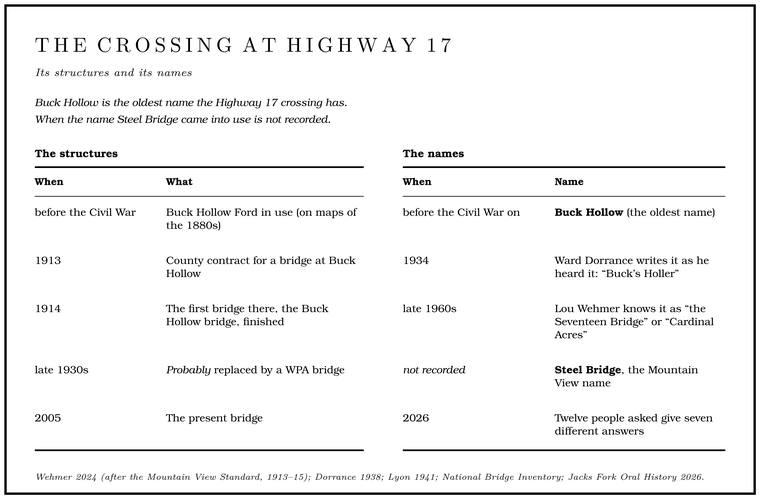
Steel Bridge is the Mountain View name. Five of the people from Mountain View and Arroll gave it, one spelling it “Steele.” Two more gave it as an alternative to Buck Hollow, one of them a newcomer of 1979 who wrote that the crossing “used to be referred to as the Steel Bridge.” No one from Eminence, Birch Tree or Springfield called it Steel Bridge. The people living in Eminence and Birch Tree said Buck Hollow or 17 Bridge Hole, and one from Springfield said Highway 17Jacks Fork Oral History, records SV-03, SV-05, SV-06, SV-09, SV-12, SV-15, SV-19, SV-20, SV-22, SV-23, SV-24, SV-25.. When the name came into use, and whether it described one of the earlier bridges, is not recorded. The bridge there now dates from 2005see Reach D..
Other names have come and gone. A Howell County historianWehmer 2024 (Lou Wehmer), the only source. who swam there as a teenager in the late 1960s knew the place as “the Seventeen Bridge” or “Cardinal Acressee Chapter 9.,” after the resort beside it (Chapter 9). He also remembered a friend calling it something he heard as “Rat Cliff,” which brought “mental visions of little rodents scurrying around the bluff.” The name belonged to the Radcliff family’s ford upstream, which, he later wrote, was “pronounced locally ‘Rat-liff,’ and by me ‘Rat Cliff.’” He was “kind of offended” when the Park Service’s signs and float maps called the place Buck Hollow, “but that’s the oldest name for it.” (For the place itself, see Reach D.)
River Hill. The descent of Highway 17 to the bridge has a name that no map prints. FourJacks Fork Oral History, records SV-03, SV-05, SV-09, SV-15, SV-19, SV-20, SV-22, SV-23. of the people asked called it River Hill. Others called it Buck Hollow, “South 17,” “Just 17” or, from Eminence, “17 Bridge Hole.” The road down was rebuilt along with the bridge (Chapter 8).
Low Water, the Forks and the Prongs
At the head of the river the names tangle. The state float guide calls the Put-in, take-out. The places where a float begins and ends (Chapter 20). Glossary → South Prong AccessMDC, South Prong Access.. The road maps call it the Highway Y crossing. Most people who grew up there call it Low Water, a name that, as one of them tells it, began with the old, low Highway Y bridgesee Chapter 8 (Jacks Fork Oral History, record SV-20, the only account of the name’s origin). (Chapter 8).
From the bridge the name spread. People now use it for the Highway Y bridge, for the access beside it, for the county road’s Low-water bridge, low-water crossing. A road crossing built low across a stream, a ford with a floor, often a concrete slab with culvert pipes beneath it, which water overtops in a rise (Chapter 8; Chapter 18). Glossary → at the junctionJacks Fork Oral History, records SV-06, SV-22. itself, where each prong runs under the road through its own culvert pipessee Chapter 8 (Table 8.1). (Chapter 8), and, in one answer, for the junction of the prongs itself. The newcomer of 1979 placed Low Water at “the Low Water. The local name for the Highway Y bridge over the South Prong, the access beside it and the county’s low-water crossing where the prongs meet, and so for the head of the river (Chapter 8; Chapter 18). Glossary → bridge on Jacks Fork road,” and a map of 1980Lewis 1980, PDF p. 12 (map, “The Forks”); see Chapter 8. letters the bridge at the Forks “Low Water Bridge.” Asked what they called the county-road crossing, people said “Low water bridge,” “Low water crossing”records SV-06, SV-05, SV-20. and “The Forks bridge.” Someone who grew up in Mountain View gave the shortest geography of all: the two prongs were “above low water.” One man defined the common noun as “A low water crossingJacks Fork Oral History, record SV-19. The term’s earlier use, Dorrance’s “first ‘low water bridge’” on the Black River, is in Chapter 8. where you drive on a concrete bridge through a creek” or across a river at low level.
The two streams above the junction have two sets of names as well. The federal maps call them the North Prong and the South Prong, and threeUSGS GNIS; Jacks Fork Oral History, records SV-05, SV-09, SV-24. of the people asked used those words. A tourist map of Texas County in 1936 called them the North Fork and the South Fork, and so did the place-name dictionaryO’Brien 1939, 94, 125. three years later, and two people asked in 2026 still sayrecords SV-19, SV-20. North Fork and South Fork. By one account the North Prong was often called Steiner’s ForkLewis 1980, PDF p. 9, the only source; see Reach A., probably for a Steiner who at one time owned the land along its upper part (Reach A). The junction is “The Forks” to four people asked and “the Prongs” to threerecords SV-05, SV-09, SV-12, SV-19, SV-20, SV-23, SV-24.. One Mountain View resident, who uses Forks, described the change: “most people start at The Forksrecord SV-20. (Now it’s called the Prongs).” The same person also called the prongs Slick Rockrecord SV-22., a name that appears in no record for the upper river, though the federal maps have a Slick Rock Hollow far downstream, in the Little Shawnee Creek drainage below EminenceUSGS GNIS; Jacks Fork Creek Network 2026 (a hollow along Little Shawnee Creek).. Another person thought the junction had been called “Jammed Up,” and was unsure.
At the other end of the river, most people asked call the mouth Two Rivers. One Mountain View native, now living in Winona, calls it the JunctionJacks Fork Oral History, records SV-09, SV-12, SV-15, SV-19, SV-20, SV-23, SV-24, SV-25..
It depends where you’re from
The Jacks Fork has several hometowns. Summersville sits on the upland north of the upper river and Arroll on the upland about a mile and a half north of the North ProngUSGS GNIS (Arroll), measured to the river centerline.; Mountain View and Willow Springs lie to the south, Birch Tree and Winona farther down, and Eminence on the lower river. A Mountain View resident who gave some of the fullest answers agreed that “People from different townsJacks Fork Oral History, record SV-20. call the same places by different names,” and also strongly agreed that the old names should be kept, “even on official maps.”
The answers of thirteen people in 2026 are a small sample, but they lean the same way (Table 18.1).
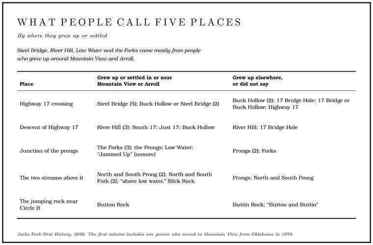
Steel Bridge, River Hill, Low Water and the Forks came mostly from people who grew up around Mountain View and Arroll. They were not theirs alone: one person whose hometown is not recorded used both River Hill and the ForksTable 18.1; record SV-23., and the Mountain View resident, asked whether people from other towns say River Hill, answered “Neighbors and yes.” The people from Eminence, Birch Tree and Springfield more often gave the sign names, Buck Hollow and Highway 17, or 17 Bridge Hole. The one who grew up in Eminence and said 17 Bridge Hole also listed three river names outsiders might not know: “Cullpepper Shoot, Steel Bridge Hole, Powell Springs (River split).” Culpepper Chute and Powell Spring are on the river near Eminence, one above the town and one below itsee Reaches I and J., and this Steel Bridge Hole is probably Eminence’s own, the pool above the town’s bridge, named for the steel bridge of 1917Lewis 1980, PDF p. 69 (“The hole of water above the bridge site is called the Steel Bridge Hole”; the narrow steel bridge was finished in March 1917); see Reach J. The record does not say where the hole is, and the other reading, the Highway 17 hole under its Mountain View name (Reach C), cannot be ruled out. (Reach J).
Around Alley, the swimming hole above the bridge is Bluff HoleJacks Fork Oral History, records SV-12, SV-15, SV-25 (marked on maps within about 600 meters of one another).. The one who grew up in Eminence described “Tall bluff with well beaten paths to the top, where we jumped off the bluff. With a big sand bar on the other side for people to watch.” Lynne Norris of Winona, who swam there, found it “about gone last time I was there.” Asked about a place called Float Rock, tworecords SV-12, SV-15, SV-20, SV-25. of four people had heard the name without being able to say where it was, and two did not know it.
Even the generic words change at the watershed line. In Howell County, on the Eleven Point side of the divide near Willow Springs, valleys could be Draw. A valley, in the usage of the Eleven Point side of the divide in Howell County (Chapter 18). Glossary →; Cane Creek’s older name was King’s Mountain DrawPottenger 1945, Howell file p. 15 (Cane Creek, Willow Springs Township).. On the Jacks Fork side they are hollows. Hollow seems to be a word of the high Ozarks. In 1939 it turned up thirty-eight times in the names of the five counties, most of them in Shannon County, and was rare elsewhere in MissouriO’Brien 1939, 190 (“seems to be one which is found commonly in the high Ozarks, but rarely in other sections of the state”); see also 233, where hollow is listed among the Americanisms.. None of the 96Jacks Fork Creek Network 2026. named creeks in the Jacks Fork watershed is a draw.
Names that live without a place
Some names survive in speech after the place itself has been lost. Asked what words they used that outsiders might not know, two people put Gar Hole firstJacks Fork Oral History, records SV-03, SV-24., one of them writing “Gar Hole near Y highway.” Six people were asked where it is. One marked it on the map about a mile and a half below the Highway 17 bridge, near the mouth of Belew Hollowrecord SV-05 (marked on a map at about mile 8.6).. Four, among them the woman who had written “near Y highway,” said they had heard of it but were not sure where it was, and one did not know itrecords SV-03 (“Heard of it, not sure where”; her “near Y highway” comes with the name only, not with a place she marked), SV-06, SV-19, SV-20; SV-12.. A Mountain View native who now lives in Winona remembered, “When I was a kidrecord SV-19. we would park on a gravel road and walk in there and fish for the day. I couldn’t find it now.”
Gar Hole is tangled with another name. The same Winona man said the upper river’s Blue Hole was “Same as gar hole.” A Mountain View resident who grew up near Arroll wrote that “Lots of places get called Blue hole. A deep, still pool. On the upper river the name has been given to more than one pool (Chapter 18). Glossary → on the upper.” Whether Gar Hole and Blue Hole were one pool or two, and where Gar Hole lay, is unsettled (The Open Ledger). On the Black River, probably in 1934, the same floater who heard “Buck’s Holler” found the water blue in its deep places and was told that “to strike blue water”Dorrance 1938, 4–5. meant to come upon a fishing pool, and he put at the head of his book a native’s advice to walk the boat over the shoals until “bye ’n bye ye’ll strike blue water.” Elsewhere in Howell County, off the Jacks Fork’s watershed, a Blue Hole HollowPottenger 1945, Howell file, “Blue Hole Hollow” (a valley drained by a small stream flowing into Dry Creek, in Siloam Springs Township, off the Jacks Fork’s watershed). recorded in 1945 took its name from “the very deep portion of the stream, Blue Hole, always filled with plenty of water of a bluish color. A good fishing place.” “Blue hole” may have named a kind of place, a deep pool good for fishing, that more than one pool could carry.
Names can also live in print without a place. Jerktail LandingNPS 1977, Current River float table and stop list. is on the Current River, between Round Spring and Two Rivers. In the story a Park Service folder told floaters in 1977, mule-skinners hauling copper and iron ore across the river there “cried ‘jerk tails’” at the critical moment, and the mules strained extra hard. Five people were asked whether Jerktail had ever named a spot on the upper Jacks Fork. Four did not know it as an upper-river name, one of them, from Eminence, adding “On the Current,” and one had heardJacks Fork Oral History, records SV-03, SV-06, SV-12 (“On the Current”), SV-19; SV-20 (heard of it). of it without knowing where.
Names that moved
The name Alleysee Chapters 4 and 5 and Reach H. probably came from a man, John Alley, and traveled by way of a post office and from there to the mill and the spring itself (Chapters 4 and 5; Reach H). In 1939 a Jam-Up Hollow reached only by horseback was one of the attractions of Rhymer’s RanchO’Brien 1939, 68; see Chapter 9. near today’s Rymers (Chapter 9), and the description fits the canyon and tunnel at Jam Up Cave. The federal maps put their Jam Up Hollow far downstream, in the Mahans CreekUSGS GNIS; Jacks Fork Creek Network 2026. drainage near Eminence. Whether these are two valleys that share a name, or one name that slid down the river on its way onto the maps, has not been settled.
The 2011 corrections
One move happened on purpose, and it took names off the federal maps and put them where local people said they belonged.
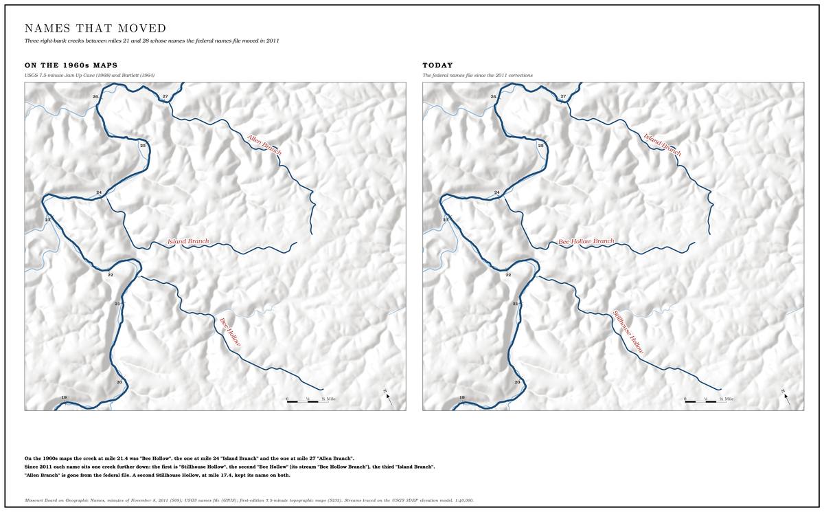
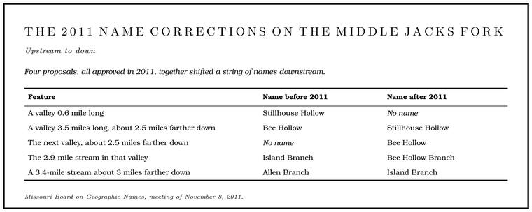
Below Rymers, a run of hollows and branches comes into the river from both sides. For decades the federal maps labeled them one way. In 2011 Tom Akers of Eminence told the Missouri Board on Geographic Names, the state body that recommends names to the federal board, that the labels were wrong and that nobody who lived there used them. He brought four proposals, which together shifted a string of names downstream (Table 18.2; Map 08).
Akers was born in St. Louis in 1951 and grew up in Eminence, finishing its high school in 1969. He took two degrees in applied mathematics at the University of Missouri at Rolla, and from 1972 through 1976 he spent his summers as a seasonal ranger at Alley Spring, in the park’s first decade. He was principal of the Eminence high school for four years before joining the Air Force in 1979. The Air Force trained him as a flight test engineer at Edwards Air Force Base, and in 1987 NASA chose him as an astronaut.
He flew four space Shuttle. The trip that brings vehicles from the put-in to the take-out, so floaters can get back (Chapter 20). Glossary → missions. In October 1990 he helped launch the Ulysses probe, bound for an orbit over the poles of the sun. In May 1992, on the first flight of the shuttle Endeavour, he was one of three astronauts who went outside together, the first three-person spacewalk, and caught a stranded Intelsat communications satellite by hand so that a new rocket motor could be fitted to it. In December 1993 he made two of the five spacewalks that repaired the Hubble Space Telescope, and in 1996 he flew to the Russian space station Mir. By the end he had spent more than 800 hours in space and about 29 hours outside the spacecraft.
Akers retired from the Air Force as a colonel in 1999 and taught mathematics at Rolla until 2010. Then he came home to a small farm near Eminence. He rode for more than twenty years as a trail boss of the Cross-Country Trail Ride (Chapter 11), and land surveying is among his pastimes. In May 2026 he was inducted into the U.S. Astronaut Hall of Fame.
Akers told the board the unnamed valley had been known as Bee Hollow for fifty years. Bee Bluff stands about seven-tenths of a mile upriver from its mouth. He said the old Stillhouse Hollow had no local name. Allen Branch was the oddest case. It had been on federal maps since at least 1917 and on the state highway map of 1938, and it went into the 1939 place-name dictionary from that highway map alone, among the names nobody there could explain. By 2011, he said, no one living in the area had heard of it.
The board first heard the proposals in May 2011, when a motion to approve them drew opposition, and it put off a decision until November while three of its members looked into the case. By its meeting of November 8, 2011, the Shannon County commissioners had approved all four changes, and the Park Service, which manages the land, had agreed. Three board members reported that they could find no documents showing the new names were correct, though two of them, Island Branch for the old Allen Branch and Bee Hollow for the valley below Bee Bluff, were already in local writing by 1980 (Reaches F and G). One of them had asked people in the area, who told him that “Col. Akers would know best about the correct names.” The old Stillhouse placement had been checked on the ground by federal fieldwork in 1968, and the view put to the board was that the trouble was “a cartographical error rather than a field error,” that is, that the names had been gathered correctly on the ground and put on the wrong valleys when the map was drawn. A motion to keep the old names died for want of a second. The board approved all four changes with one abstention and provided for a note in the federal record giving the original names. The U.S. Board on Geographic Names adopted all four changes on January 12, 2012.
Stillhouse. A building where whiskey was distilled. Several hollows on the river carry the name (Chapter 18; Reach F). Glossary →, for the place where whiskey was made, is a common name in Missouri. Fifteen Missouri valleys carry it, three of them in Shannon County. The watershed has a Stillhouse Branch on the South Prong and, besides the corrected one, another Stillhouse Hollow on the federal maps, entering the river from the left about four miles above it. A longtime angler and hunter of the middle river has other names for both, calling the shorter hollow “Little stillhouse” and the corrected Stillhouse Hollow, the valley the 2011 changes renamed, “Nickelloff.”
Other names repeat in the same way. There is a Bee Bluff on the middle Jacks Fork and another on the Current, a Blue Spring on each river, Pine Hollows on the South Prong and on Mahans Creek, and Spring Hollows on the middle river and on Storys Creek.
Spellings that drift
Most of the river’s names were spoken long before anyone wrote them down, and some changed in the writing (Table 18.3).
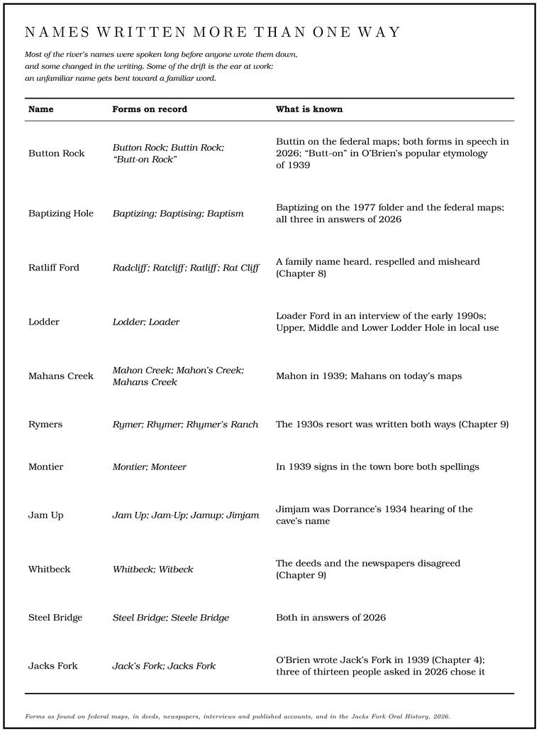
Some of the drift is the ear at work. An unfamiliar name gets bent toward a familiar word: Lodder becomes Loader, and Radcliff becomes Rat Cliff. Button Rock is still unsettled. Asked how they spell the jumping rock near Circle B, a Mountain View resident wrote “Button Rock,” the Eminence resident who has done park work wrote “Buttin Rock,” and Lynne Norris of Winona answered, “Ive heard Button and Buttin.” The federal maps print Buttin.
Some drift runs from the map back into speech. A Howell County newspaper columnistWhitaker 2025 (Lonnie Whitaker), the only source. grew up saying Ratliff for the ford above Highway 17, then saw “Rat Cliff” on a federal topographic map and wondered whether his mother, “who occasionally had quirky pronunciations, had gotten it wrong and I learned it from her.” The family name was Radcliffsee Chapter 8. (Chapter 8).
The creeks nobody named
Underneath the named places is a larger map of unnamed ones. It can be drawn from federal elevation data, a grid of ground heights in cells about 40 meters across. Water on each cell is taken to run to its lowest neighborJacks Fork Creek Network 2026 (3DEP 1/3 arc-second elevations at about 40-meter cells); the tracing method is the standard one., and following those steps downhill and counting how much ground drains through each cell picks out the channels. Keeping every channel that drains at least a square kilometer, about 250 acres, the Jacks Fork watershed has 285 creeks. Ninety-six carry a name on federal maps or in the federal names file. The other 189 have no recorded name (Map 18.1to be drawn from the same data.).
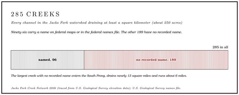
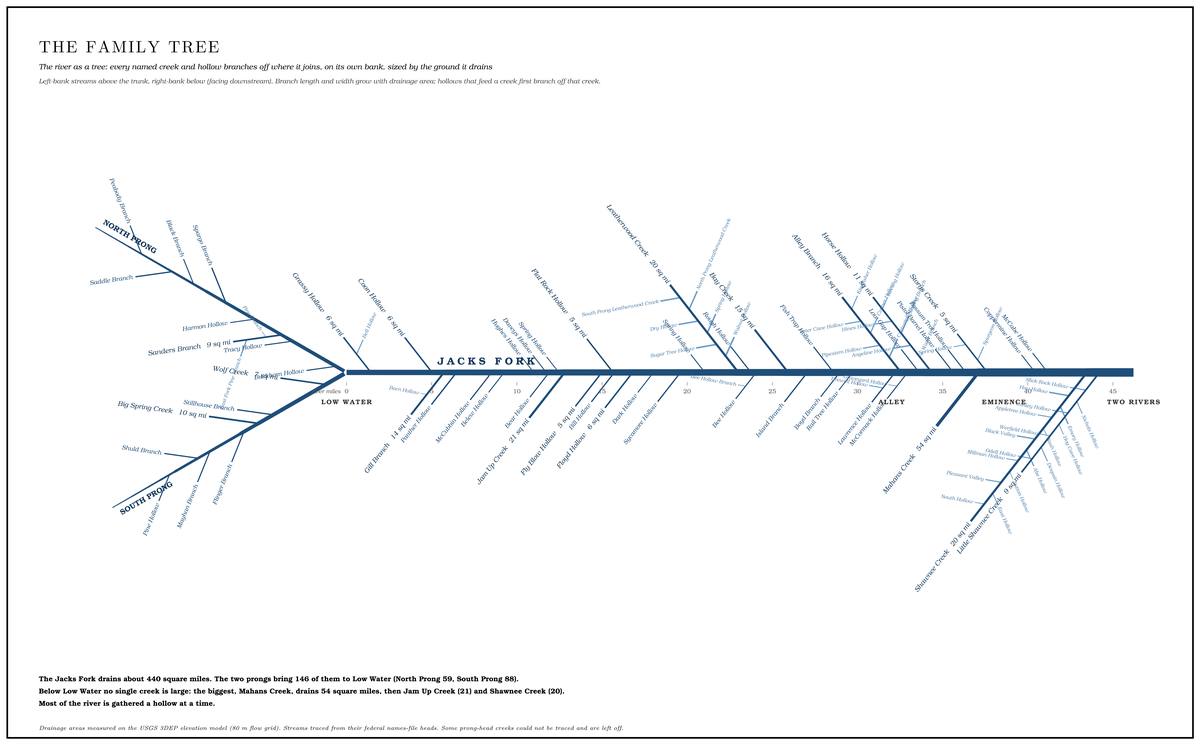
Most of the nameless oneJacks Fork Creek Network 2026 (the largest unnamed creek, on the South Prong, 33.4 square kilometers, 9.5 kilometers long).s are small: 108 drain less than two square kilometers, most of them steep side hollows. Eighteen drain five square kilometers, about two square miles, or more. The largest, a creek entering the South Prong, drains nearly thirteen square miles and runs about six miles, and no official record names it. Of the 90 creeks that run straight into the Jacks Fork or one of its prongs, 31 have no recorded name.
Sixty-one of the 96 named creeks are named as hollows, 21 as branches, 13 as creeks and one as a valley, and the water in a valley’s bottom generally carries the valley’s name.
Some of the unnamed creeks have names in speech. The angler and hunter of the middle river gave “Spring hole”Jacks Fork Oral History, record SV-23. for a side branch the maps leave blank, and called the creek the maps label Spring Hollow “Big bear.” The creek that runs through Mountain View between the football field and First Street is the head of Jam Up Creek, which reaches the river about nine miles away by its channelJacks Fork Creek Network 2026 (about six miles in a straight line); see Chapter 12. (Chapter 12). The Mountain View resident gave the town’s creek the name of the creek it becomesrecord SV-20 (written “Ham Up Creek,” taken here as Jam Up)., said it “Runs into Jacks Fork,” and agreed that “Most of the little creeks around here have names that only locals know.”
The words for water
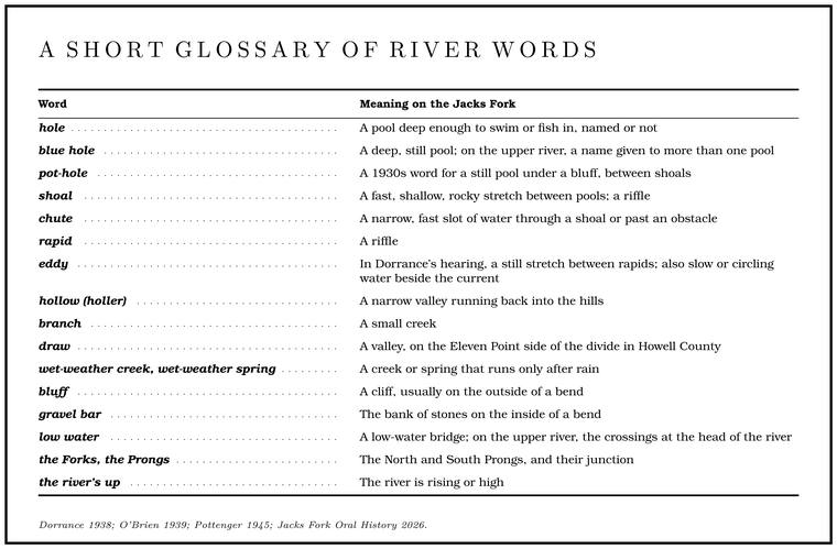
Beneath the names is a vocabulary for the river’s parts. The basic unit is the hole, any pool deep enough to swim or fish in, named or not. In a drought summer, probably 1934, the upper river’s whole course was summed up for a passing floater as “shoals and Pot-hole. A 1930s word for a still pool under a bluff, between shoals (Chapter 18). Glossary →, jest shoals and pot-holes,” the pot-hole being a still pool under a bluff and the shoal the fast, shallow water between (Chapter 15). On the Black River a man told him to expect three “Rime. A rapid, in the 1930s speech of the Black River (Chapter 18). Glossary →” and three eddies, the rimes being rapids and the eddies the still stretches in betweenDorrance 1938, 13–14 (“quiet stretches in between”).. Hydrologists speak of the Riffle. A fast, shallow, rocky stretch between pools. The riffles are the gardens of the riverbed: in July a square meter of riffle produced more than six times as much as a square meter of pool (Chapter 16). Glossary →, the pool and the barsee Chapter 15. (Chapter 15).
Asked in 2026 for words outsiders might not know, people mostly gave names of places: Gar Hole, Jam Up, Pebble Dam, Slick Rock, “honey hole,” Cottonmouth Bar, Cullpepper Shoot, Powell Springs “(River split).” A few gave words: riffles; “Riffle. Chute. A narrow, fast slot of water through a shoal or past an obstacle. A smooth V of water pointing downstream marks the deepest path through it (Chapter 20). Glossary →. Hole of water. Crossing”; “Swift CurrentJacks Fork Oral History, records SV-03, SV-09, SV-15, SV-22, SV-23, SV-24, SV-25..” Someone from Mountain View offered two everyday names for the river itself, “Watering hole or The Creek.” Four of thirteenrecords SV-09, SV-15, SV-17, SV-22. called it the river.
The fullest set of words came from the Mountain View resident, choosing among alternatives for each. For a riffle the choice was “rapid,” for a blue hole “a bluff hole,” and for water that runs only after rain a “wet weather spring” and a “Wet-weather creek, wet-weather spring. A creek or spring that runs only after rain (Chapter 18). Glossary →.” The boat was a jon boat, the fish Goggle-eye. The river’s name for the shadow bass, a sunfish, and in the state’s rules for the rock bass and its kin. The name was in use by 1840 (Chapter 16; Chapter 18; Part Six). Glossary → and suckers, the crayfish a Crawdad. The local word for a crayfish, an alteration of crawfish used chiefly west of the Appalachians (Chapter 18). Glossary →, a rise “the river’s up” and the park “the Riverways.” A float was “a Float trip. A trip down the river by boat, from a few hours to several days, with a way back arranged at the end (Chapter 20). Glossary →see Chapter 20.” (Chapter 20), and heading out was “Going to the river.”
The land around the river has its own words. A hollow, written “holler”Dorrance 1938, 26. in the 1930s to catch the way it was said, and noted in Howell County in 1945 as “also pronounced ‘holler’ locally,” is a narrow valley running back into the hills. A branch is a small creek. A bluff is the cliff, usually on the outside of a bend, and a Gravel bar. A bank of chert gravel and sand, usually on the inside of a bend, bare at low water (Chapter 15; Chapter 18). Glossary →see Chapter 2. the bank of stones on the inside (Chapter 2). A ford is where a road crosses through the water, and a Low-water bridge, low-water crossing. A road crossing built low across a stream, a ford with a floor, often a concrete slab with culvert pipes beneath it, which water overtops in a rise (Chapter 8; Chapter 18). Glossary →see Chapter 8. a ford with a floor (Chapter 8).
Several of these words grew up on this side of the Atlantic. When the region’s name words were checked against the standard dictionaries in 1939 for a list of Americanisms, bluff, for a high bank with a steep front along a river, turned out to have been first used in North America, with a first record from 1737. Branch for a small stream is an American sense recorded from 1674, and fork, for a tributary or for the place where two streams meet, is chiefly American, from 1753. Prong, the word on the federal maps for the two streams at the head of the river, had been set down in 1860 as Southern usage for “a branch or arm of a creek.” Lick, for a spot where animals come to Lick. A spot where animals come to lick salt or salty earth, an American word from 1751 (Chapter 18). Glossary → the salt or salt earth, is American from 1751, and sink, for a hole in Limestone. Calcium carbonate rock formed from lime mud and shells on a sea floor. Most of the limestone laid down here later became dolomite (Chapter 1). Glossary → country where the water sinks and is lost, is an American use as well. Hollow is the old English word for a valley, in use since the 1550s, though American place names took it up in great numbersO’Brien 1939, 224–25, 227, 231, 233, 236, 238 (the appendix of 109 Americanisms, with the dictionaries’ earliest dates; prong after Bartlett’s Dictionary of Americanisms, 1860; hollow not an Americanism in two of the dictionaries, earliest example 1553, but “used in many place names in the U.S.”).. Some of the river’s everyday words are American as well. Johnboat, for the narrow, flat-bottomed, square-ended boat poled or paddled on inland waters, is in print from 1894. Crawdad, an alteration of crawfish used chiefly west of the Appalachians, is recorded from 1878, and goggle-eye was a name for the rock bass by 1840Merriam-Webster (river words), “johnboat,” “crawdad,” “goggle-eye” (dates of first known use)..
Some words stayed local. A Wassie. A rain wash or a swamp, in the local dialect (Chapter 18). Glossary →, in the dialect, was a rain wash or a swamp. The Shannon County village of Low Wassie, first called Pomeroy, became Low Wossie in 1892, named for a Sinkhole. A hollow in the ground where rock below has dissolved or caved in, through which water drains underground; also called a sink, an American use (Chapter 2; Chapter 12). Glossary → close by, and took the spelling Low Wassie in 1925O’Brien 1939, 79..