In Texas County there was an old joke about the river. A man convicted of a crime, the joke went, could choose five years in the state prison or one year on Jack’s Fork. A Houston attorney who also abstracted land titlesO’Brien 1939, 67 (C. Covert of Houston), ix (“Mr. and Mrs. Charles Covert, attorney and abstractors of Houston”). passed it on in the late 1930s to a University of Missouri graduate studentO’Brien 1939, 67 (Anna O’Brien’s master’s thesis on the place names of five Ozark counties). who was collecting place names for her thesis. Hers was the twelfth thesis in a systematic study of Missouri’s place names that the university had begun in 1928, and the eleven before it had already treated more than seventeen thousand names from 82 counties. Robert L. Ramsay of the English department, who directed the work, spent what she called a sort of busman’s holidayO’Brien 1939, iv (research “started at the University of Missouri in 1928” and “continued under the supervision of Dr. Robert L. Ramsay of the English Department”; “eleven theses have been completed, treating 17,?50 place names from 82 counties,” one digit unreadable in the scan; “This twelfth study is a continuation of the project”), ix (“Dr. Ramsay, on a sort of busman’s holiday, collected valuable and exact information in Shannon County”). gathering names in Shannon County himself. The river, she wrote, “flows through land which is very wild and forbidding,” and it was “becoming a favorite resort for fishermen.” Her entry for the river, drawing on a 1933 plat book and three local informants, also gave its origin: the river was “named for an old Indian, John Jacks, who lived near the head of the stream.” The entry carries the R she prefixed to her authorities when Ramsay had helped solve a name, and no asterisk, the sign she gave an explanation open to reasonable doubtO’Brien 1939, ix (“an R has been prefixed when aid in the solution was given by Professor Ramsay”; a single asterisk “when a reasonable doubt exists about the validity of the explanation”), 67 (the entry’s authorities begin “R:” and the entry carries no asterisk)..
That is the earliest explanation of the name found, and it is not the only one. Later tellings make Jack a Shawnee who settled at the headwatersMDC, Jacks Fork Natural Area., a Shawnee chief called Captain Jack who got his title by trading for a ferryman’s hat, a Cherokee who bred race horsesKennedy 1998, 10., or a bear hunter named Jack Thomas whose camp was torn apart by a pantherLewis 1980, PDF p. 5; MSS 1982, 1; NPS 2015 (place names).. None of them has been traced to a document from Jack’s own lifetime. The documents do show the country the stories come from. For generations these hills were Osage hunting groundZedeño and Basaldú 2003, 16, 34.. Then, for a few years around 1820, Delaware and Shawnee familiesBrown 1969, 6; Zedeño and Basaldú 2003, 82; Stevens 1991, 18. who had been pushed out of the East camped and planted along the Current and the Jacks Fork on their way farther west.
Osage hunting country
The Osage called themselves Ni-U-Ko’n-Ska, the Children of the Middle WatersWolferman 1997, 10; Lookingbill 2020.. The word Osage is a French rendering of Wa-zha’-zhe, the name of the tribe’s Water division, which outsiders applied to the whole peopleBailey 2010, 16, 157 n. 76; Baird 1972, 12.. They spoke a Siouan language of the Branch. A small creek. The sense is American, on record from 1674 (Chapter 18). Glossary → called Dhegiha, as the Kansa, Ponca, Quapaw and Omaha did. By their own tradition their people once lived in the Ohio Valley with the other Dhegiha peoples, though other accounts bring them from the north or from the Southeast. At one time they were the most numerous people in Missouri, and one estimate puts them at about sixty-two hundred in 1780Wolferman 1997, 6–8 (the Ohio Valley tradition as accepted by the ethnologist James Owen Dorsey; the 1780 estimate as reported by John R. Swanton).. When Marquette and Joliet came down the Mississippi in 1673, the Osage controlled the country of the Current and the Jacks ForkStevens 1991, 14; Zedeño and Basaldú 2003, 34.. Their claim ran from the Missouri River south to the Arkansas and from the Mississippi west into present Kansas, close to a hundred thousand square milesLookingbill 2020., and they defended it hard, at one time or another against the Sac and Fox to the north, the Pawnee to the west and the Caddo to the southStevens 1991, 14..
They did not live on the Jacks Fork. Through the eighteenth century the Big Osage villages stood on the upper Osage River, near the western edge of present Missouri, and the Little Osage lived for a time on the Missouri RiverWolferman 1997, 10; Brown 1969, 5; Zedeño and Basaldú 2003, 61.. Around 1800 a third group broke away and moved to the Three Forks of the ArkansasWolferman 1997, 10, 45; Zedeño and Basaldú 2003, 63–64., in what is now Oklahoma. From the Current River valley the Big Osage towns were about 160 milesBrown 1969, 5. to the west and the Little Osage about the same distance to the northwest. The villages were permanentStevens 1991, 14.. Their houses, framed with bent poles and covered with woven mats or buffalo hides, were at least fifteen feet wide and from thirty to more than forty-five feet longWolferman 1997, 11., and the women planted corn, beans and squash in family gardens outside the ring of housesWolferman 1997, 15..
The Ozarks were hunting country. In early summer and again in fall, whole villages moved to camps on the prairies of western Missouri and eastern Kansas for communal bison huntsBailey 2010, 9.. In winter, families scattered in small parties across the Ozarks, in an arc that reached south to the Ouachita Mountains, after deer, bear, beaver, otter and other game. The winter hunt grew more important as the fur trade grew, because its hides and pelts were the tribe’s main trade goods. Furs went to market in packs, bundles of skins pressed and tied for carrying, and St. Louis became the headquarters of the tradeWolferman 1997, 24–25.. In the 1750s and 1760s the Osage and the Missouri together were reported to trade about 80 packs of skins and hides a year. By 1800 the Osage alone were trading about 950, and theirs was the most valuable trade in Spanish LouisianaBailey 2010, 10.. Beaver and bear counted for little as food, and the hunt for them ranged east as far as the St. Francis River. Perhaps it was on these winter huntsZedeño and Basaldú 2003, 65. that Osage parties used the eastern Ozarks near the Current.
The hills probably mattered to the Osage as defense as well as hunting ground. The Ozark forests were full of the fur-bearers the Osage most needed, bear and beaver above all, which supplied both fur and fat. The rough, broken country also lay between the prairie villages and the tribes to the eastRollings 1992, 185, quoted in Zedeño and Basaldú 2003, 64 (“The Ozark forests were particularly important to the Osage. Fur-bearing animals, especially the important bear and beaver, which supplied fur and fat for the Osage, thrived in the forests”; “The rugged mountain country served as a buffer from the eastern tribes”)., and kept those enemies at a distance. The distance did not always hold. As eastern refugee bands settled west of the Mississippi with Spanish encouragement in the late eighteenth century, small raids on hunting camps became common on both sides, and by the 1790s no small party of Osage huntersBailey 2010, 10 (“Small-scale raiding of hunting camps by both sides became common. By the 1790s … No small party of Osage hunters or travelers was safe”)., at a bison camp or a winter camp, was safe from attack.
How often Osage hunters came as far east as the Jacks Fork is not known. Records of the Osage on the Current and the Jacks Fork are very few, and their use of the area may have been limited to occasional huntingZedeño and Basaldú 2003, 34 (“There is very little reference to direct Osage presence in the Current and Jacks Fork rivers”; their use “may have been limited to sporadic hunting”).. Local tradition gives them a bigger place. By a history of the river written down in 1980, the Osage made two hunting trips a year to the river country of southern Missouri and camped a couple of months each time, and they were reputed to be the most powerful warriors in America, more than a match for the Shawnee and DelawareLewis 1980, PDF p. 74 (“It was an annual practice for the Osage to make two hunting trips to the river country in Southern Missouri. They would camp and spend a couple of months on these trips”; they “were reputed to be the best physical specimens and the most powerful warriors in America”; “The Shawnee and Delaware were no match for the savage Osage”), the only source.. An old Indian trail known as the Virginia Warrior PathZedeño and Basaldú 2003, 35. crossed the Ozark highlands between the Current and the Eleven Point. An Osage trade route to St. Louis crossed the lower Current in Ripley County. It was one side of a long loop. From the villages the hunting parties went south to the Verdigris and Red rivers, turned east to the trail between Natchitoches and Vincennes, and followed it northeast through southeast Missouri to St. Louis, hunting along the way, in the southern Current River basinStevens 1991, 15. among other places, and trading their furs in the city. In 1818 the explorer Henry Schoolcraft found an empty Osage hut west of Potosi, and in the White River country three vacant Osage winter camps, each big enough, he thought, for about a hundred menBurns 2004, 45.. Settlers south of the Current were so afraid of the Osage that he could not find one willing to guide himStevens 1991, 14. southwest into Arkansas.
The ground has given up little that can be tied to them. Local collectors have small triangular arrow points from sites in and near the park. Points like them turn up with late prehistoric peoples of the southeast Missouri lowlands and with the historic Osage and MissouriPrice, Price and Saucier 1987, 67., and nobody can say which these are. A different kind of record is in the trees. Shortleaf pines, living and dead, on a slope near Alley SpringKing and Muzika 2014, 79–80. record 39 fires between 1706 and 1915, one about every five and a half yearsKing and Muzika 2014, 78, 81. (fire in the Ozark woods is the subject of Chapter 16). A fire in 1753, during a drought that lasted several years, scarred more than a third of the pines then alive. The drought may account for it. So may the Osage, who are said to have made periodic trips into the Missouri Ozarks from southwest MissouriKing and Muzika 2014, 83–84 (the Osage “made periodical migrations into the Missouri Ozarks from southwest Missouri”)..
A line south from Fort Osage
After the Louisiana Purchase of 1803 the Osage faced a new government, and a hungrier one. Settlers and land speculators crossed into Missouri at about two thousand a yearWolferman 1997, 67., and the first American settler reached the Current River country in the first decade of the century, by local accountsStevens 1991, 24–25 (Isaac Kelley, after local histories); Zedeño and Basaldú 2003, 68; Lynott 1981, 53 (Zimri Carter, about 1807).. The Osage kept raiding settlers and emigrant tribes alike, and between 1805 and 1808Stevens 1991, 17. their fighting with the Cherokee, Shawnee and Delaware who had moved into their country grew worse. In 1808 the territorial governor, Meriwether Lewis, set out to stop them. He cut off trade to the bands that would not follow the Big Osage chief White Hair, and he sent soldiers up the Missouri to build a fort and a government trading house on a Bluff. A cliff along the river, usually on the outside of a bend, where the river has cut sideways into the hill. In this sense the word was first used in North America (Chapter 2; Chapter 18). Glossary →Wolferman 1997, 1. above Fire Prairie, near the present town of SibleyChapman and Chapman 1983, 120., east of Kansas City. It was called Fort Clark at first and soon Fort OsageZedeño and Basaldú 2003, 68..
William Clark, Lewis’s partner on the Pacific expedition, came overland with eighty mounted volunteers from St. Charles and reached Fire Prairie on September 4, 1808. When the Osage arrived and camped near the half-built fort, he had their chiefs sign a treaty within two daysWolferman 1997, 65–68.. Many chiefs were absentZedeño and Basaldú 2003, 68. and many never heard of it, and members of bands that had been represented complained that the interpreter had not told them they were giving up land. Lewis wrote a new treaty himself and sent Pierre Chouteau, the government’s Osage agent, to present it. Chouteau had grown up among the OsageZedeño and Basaldú 2003, 65. and knew their language. The terms were not open to bargaining, and Osage who refused were to get no trade goodsWolferman 1997, 69.. “The Great White Father is strongWolferman 1997, 71.. We are weak. We have no choice but to accept,” the Little Osage chief Sans Oreille supposedly told the others. On November 10, 1808Kappler 1904, Treaty with the Osage, 1808; Wolferman 1997, 71., at Fort Clark, they signed.
The treaty drew a line from the fort due south to the Arkansas River. The Osage gave up everything east of it between the Missouri and the Arkansas, and all their claims north of the MissouriKappler 1904, Treaty with the Osage, 1808, art. 6.. By the largest reckoning, an Osage historian’s, the cession came to seven-eighths of Missouri and half of Arkansas, at least 52 million acres; other accounts put it at about three-quarters of MissouriStevens 1991, 14 (“the eastern three-fourths of Missouri”); other figures are given, among them about 50,000 square miles (Zedeño and Basaldú 2003, 68).. The Jacks Fork lay deep inside it (Map 4.1). The land, Lewis said, “was needed for white hunters and intimately friendly Indians.” In return the Great Osage were to receive $1,000 a year in merchandise and the Little Osage $500, with $800 and $400Kappler 1904, Treaty with the Osage, 1808, art. 5. paid at the signing, a blacksmith, a mill, plows and a trading housesame, arts. 2–3. at the fort. All the compensation together came to less than one-sixth of a cent an acreBurns 2004, 168; Louis F. Burns was Osage (Osage News 2012; University of Alabama Press, “Louis F. Burns”)., which is less than 27 cents for a quarter Section. A square mile of 640 acres, one thirty-sixth of a township. A quarter section is 160 acres (Chapter 5). Glossary → of 160 acrescomputed from Burns’s figure.. Chiefs of the Arkansas bands signed their own acknowledgment at St. Louis on August 31, 1809, and the treaty was ratified on April 28, 1810same; Burns 2004, 144–45..
The Osage did not think they had sold their hunting grounds. Article 8Kappler 1904, Treaty with the Osage, 1808, art. 8. let Osage who lived under the fort’s protection keep hunting “without molestation” on the lands west of the line where they had usually hunted, and on other lands of Louisiana outside the white settlements, “until the United States may think proper to assign the same as hunting grounds to other friendly Indians.” The Osage seem to have taken that to mean that every area not settled by Americans or given to emigrant nations remained Osage hunting ground, and the English wording was probably so tangled that rendering it in Osage would have been close to impossibleBurns 2004, 154.. The Osage, especially those who had not been present, said afterward that they had meant to share their hunting rightsZedeño and Basaldú 2003, 68., as they had shared them before with friendly nations, rather than give them up. Emigrant nations soon moved into the ceded hills, and within a dozen years Delaware and Shawnee families were living on the Current and the Jacks Fork.
Two more treaties finished the work in Missouri. On September 25, 1818, at St. Louis, the Osage gave up a tract between the Arkansas and VerdigrisKappler 1904, Treaty with the Osage, 1818. rivers, land the Cherokee wantedZedeño and Basaldú 2003, 69. after years of war with the Osage over the Arkansas valley, where the Cherokee numbered about three thousand after the War of 1812Stevens 1991, 14.. On June 2, 1825, again at St. Louis, the Great and Little Osage ceded all their remaining lands in Missouri and Arkansas Territory and far to the west. They had little choice. War had cost them heavily, and they had come to depend on trade with the Americans and on the yearly payments owed them under the treaties, which the government cut or held back to pay damages claimed by settlers and other tribes until the Osage were destituteStevens 1991, 15.. By one account William Clark called it the hardest treaty he had ever made, and feared he might be damned in the hereafterWolferman 1997, 102 (“Governor Clark said this was the hardest treaty he had ever made, and he feared he might be damned in the hereafter for his part in the agreement”), which gives no source for the remark. It could not be traced to an earlier source in this pass, and it is told here as one account. for his part in it. The Osage kept a strip fifty miles wide beginning twenty-five miles westKappler 1904, Treaty with the Osage, 1825, arts. 1–2. of Missouri’s western line, in what became Kansas. The Osage historian insisted that the strip was no gift: “the United States government did not give the Osages any reservation at any time.” By that reckoning every reservation the Osage occupied had been their own territory long before the United States claimed it.
| Date | Place | Nations | What it did |
|---|---|---|---|
| Nov. 10, 1808 | Fort Clark (Fort Osage), on the Missouri | Great and Little Osage | Ceded the land east of a line due south from the fort to the Arkansas River, including the Jacks Fork, and all claims north of the Missouri; ratified Apr. 28, 1810 |
| Aug. 31, 1809 | St. Louis | Osage bands on the Arkansas | Confirmed the 1808 treaty |
| Sept. 25, 1818 | St. Louis | Great and Little Osage | Ceded the tract between the Arkansas and Verdigris rivers |
| Oct. 3, 1818 | St. Mary’s, Ohio | Delaware | Gave up the Delaware lands in Indiana for a new country west of the Mississippi |
| June 2, 1825 | St. Louis | Great and Little Osage | Ceded all remaining lands in Missouri and Arkansas Territory; kept a strip in present Kansas |
| Nov. 7, 1825 | St. Louis | Shawnee | Ceded the Cape Girardeau tract for land west of Missouri |
| Sept. 24, 1829 | Council Camp, James Fork of the White River | Delaware | Relinquished all Delaware claims in Missouri, including the James Fork country, for land in the fork of the Kansas and Missouri rivers |
| Oct. 26, 1832 | Castor Hill, St. Louis County | Shawnee and Delaware “late of Cape Girardeau” | Ceded all their remaining lands in Missouri |
Losing title to the hills did not end the hunting. Osage parties kept coming into the ceded countryZedeño and Basaldú 2003, 68; Stevens 1991, 14.. In 1837, with the buffalo driven far to the west, they returned to their old Missouri hunting grounds, and that year the Missouri militia droveLookingbill 2020. Osage, Shawnee and Delaware hunting parties out of the state. Whether the Osage reached the Current that year is not knownZedeño and Basaldú 2003, 34.. Indian hunting parties probably visited the Current River country into the 1850sZedeño and Basaldú 2003, 36.. The Osage themselves had less reason to come. By the 1830s war and disease had brought them down to about fifty-five hundred people, the eastern nations were “now over-running the former hunting grounds of the Osage,” as one of the Chouteau traders wrote, and the market was changing under them. Bearskins, deer hides and beaver were worth less, buffalo robes more, and by the 1850s the Osage, still within reach of the bison herds, were trading twenty thousand robes a yearBailey 2010, 12 (quoting a letter of Pierre Chouteau of the 1830s, which Bailey gives as “these [eastern] Indians . . . are now over-running the former hunting grounds of the Osage”)..
White hunters were in the same hills, and the two did not always meet in peace. A story from the upper Jacks Fork, with no date and no tribe named, tells of one such meeting. A party of hunters from the Eleven Point country, by this account, made camp at Cold Springs and left an old man, William R. Smith, a veteran of the Revolutionary War, to skin and dress the game and keep the camp. When they came back they found him dead, killed, as they read it, by Indians. His son John was reputed afterward to have killed several Indians to even the scoreLewis 1980, PDF p. 14, the only source (the hunters came “from the Eleven Points River near Thomasville”; the account’s description of the wounds is what ties the killing to Indians; John “was reputed to have killed several Indians to even the score”). No date is given. See Reach C. (Reach C).
Newcomers from the east
The Delaware call themselves LenapeDelaware Tribe of Indians, “About.”, which means something like “the People.” When Europeans arrived they lived along the Delaware River and around Delaware Bay, in what are now eastern Pennsylvania, New Jersey and southeastern New York, Manhattan Island included. Other Algonquian nations called them Grandfathers. They were never a single political unitZedeño and Basaldú 2003, 78., and the name Delaware, first given to the people of the middle Delaware Valley, was stretched to cover all of them only after they had left. Their removals were long and piecemeal. Between 1709 and 1742 large groups left the Delaware and Schuylkill valleys for the West Branch of the Susquehanna. In 1752 some 250 families settled on the upper Ohio in western Pennsylvania, and during the French and Indian War more crossed the Alleghenies to join them. Settlers pressing on their land after that war sent many west again, at the invitation of the Wyandot, to the Tuscarawas and Muskingum rivers in Ohio, and in 1765, at the end of Pontiac’s War, the Delaware gave up their claims east of the Alleghenies. After the defeat of the western nations at Fallen Timbers, the Treaty of Greenville in 1795 took their Ohio lands, and the Miami invited the Delaware onto the West Fork of the White RiverZedeño and Basaldú 2003, 79–80, after Weslager 1978. in Indiana. The Delaware Tribe’s own short history gives the rest in one line: “first to Ohio, then to Indiana, Missouri, Kansas, and finally, Indian Territory, now Oklahoma.”
The Shawnee spoke a related Algonquian language and were at times allies of the Delaware. They were a scattered people, never united into a single society. In the second half of the eighteenth century many lived in southern Ohio, but Shawnee groups had been reported from Illinois to the Savannah RiverZedeño and Basaldú 2003, 83, quoting Callender 1978 (“an exceptionally fragmented people, … never united into a single society”).. As the two nations moved west, a migrating band of oneZedeño and Basaldú 2003, 84. often included families of the other.
They first came west of the Mississippi at Spain’s invitation. After the American Revolution Spain held Louisiana, and it wanted friendly nationsBrown 1969, 5; Stevens 1991, 16. between its thin line of settlements and both the Americans and the Osage. The newcomers had their own reasons to cross. The settlements and the travelers on the Mississippi were a growing market for furs, hides and surplus foodStevens 1991, 16., and American settlement was pressing on them from the east. Shawnee and Delaware families had villages around Cape Girardeau by about 1784, and when the land speculator George Morgan came down the Ohio in the fall of 1788 he found a band of about twenty Delaware camped in the Mississippi Bottom. The flat land along a river or creek, built of its deposits and open to its floods. In the 1920s the bottoms near Eminence averaged about a quarter of a mile wide (Chapter 2; Chapter 5). Glossary →, in what is now Mississippi CountyZedeño and Basaldú 2003, 80–81, quoting Houck 1908, 1:208.. Louis Lorimier, a French-Canadian trader who had served the British as an interpreter during the war and whose wife was of mixed Shawnee and French ancestry, settled in the Cape Girardeau district as a Spanish Indian agent and brought more of them in. The Spanish governor, the Baron de Carondelet, gave the Shawnee and Delaware permission to settle on a tract about twenty-five miles square along the Mississippi, reaching back to the WhitewaterKappler 1904, Treaty with the Shawnee, 1825, preamble and art. 1. River, and the grant was made formal in 1793Zedeño and Basaldú 2003, 85.. The Spanish grants were for about 1,200 Shawnee and 600 Delaware, who built several villages between Cape Girardeau and Ste. Genevieve. They cleared and fenced fieldsStevens 1991, 16–17., raised livestock and sold bear oil, furs and surplus food in the river towns, and a few Cherokee and CreekZedeño and Basaldú 2003, 84. lived among them. Settler families around Apple Creek, in the Cape Girardeau district, later remembered Indian and white children playing together, and horse races and festivals that drew both peoples, and marriagesStevens 1991, 17 (pioneer family reminiscences). between the two were common in the first decades of the nineteenth century.
The Osage treated them as trespassers on their hunting grounds. Through the 1790s the Delaware and Shawnee raided the Osage, encouraged by Spanish officials who until 1794 meant to destroy the OsageChapman and Chapman 1983, 120. altogether, and the two sides were at war until about 1802. After the Louisiana Purchase, American settlers moved into Missouri in growing numbers, and the Shawnee and Delaware were pushed slowly westBrown 1969, 6. ahead of them. Relations soured during the War of 1812, when Shawnee, Delaware and Creek bands east of the Mississippi sided with the British, and after the war the Missouri villages began to move west and southwest. The Delaware abandoned the Cape Girardeau tract in 1815Kappler 1904, Treaty with the Shawnee, 1825, preamble.. Some of the Shawnee and a few Delaware went to the Gasconade valley, and larger groups of Delaware went toward the James River and northern ArkansasStevens 1991, 17–18.. When Schoolcraft crossed the Ozarks in 1819 he found Delaware villages and camps on the North Fork of the White River and was impressed by how clean and orderlyZedeño and Basaldú 2003, 82. they were. Some of the Delaware stopped on the Jacks ForkZedeño and Basaldú 2003, 81, after Morrow 1981..
Meanwhile the main body of the Delaware, then living on the White River in Indiana, signed the Treaty of St. Mary’s in October 1818 and gave up their Indiana lands. They had to be out by 1821. Their head chief, William Anderson, whose Lenape name, KikthawenundJackson 2009 (“Loosely translated the name means, creaking boughs”), the only source found for the meaning; the Delaware Tribe of Indians’ own genealogical study of the chief, by Ruby Cranor, is titled Kik Tha We Nund., is said to mean something like “creaking boughs,” was the son of an American father and a Delaware mother. He had lived all his life among white Americans and had already negotiated with the government over their removal from Ohio at Greenville in 1795. The new treaty gave the nation $4,000 a year. A payment of that kind, owed yearly under a treaty in money or goods, was called an annuity, and the cash drew white tradersStevens 1991, 18. after the Delaware across Missouri. The officials in charge wanted the eastern nations settled where they could farm and lean less on government suppliesZedeño and Basaldú 2003, 82 (correspondence of Graham, Clark and Chouteau, Richard Graham Papers, 1820–1822)., and the governors of Missouri and Arkansas agreed that the James River valley, south of the future site of Springfield, would make a good interim reserveZedeño and Basaldú 2003, 81–82.. To reach it the Delaware had to cross the Ozarks.
The Delaware on the “Currents”
On January 26, 1821, William Clark sent a letter with a map of the lands granted to the emigrant nations west of Missouri’s western line. On the same map he drew an oval about 45 by 90 milesBrown 1969, 6–7 n. 5., running from below the mouth of the Jacks Fork to above the head of the Current, and inside it he placed the Shawnee and Delaware from Cape Girardeau. An oval that size covers about seven times the area of the whole Jacks Fork watershedcomputed from the oval’s axes (about 3,200 square miles) against the watershed’s 445 (Wilkerson 2001, PDF 1; Chapter 2).. By 1820Brown 1969, 6. families of both nations were living along the upper Current and the Jacks Fork.
From 1820 to about September 1822, Delaware families camped and planted along the Current in what are now Shannon and Carter counties. In the winter of 1821–22 a second groupPrice, Price and Saucier 1987, 66 (the Richard Graham Papers, Missouri Historical Society, St. Louis). coming from Ohio and Indiana joined them. Their supplies passed through Richard Graham, the Indian agent at St. Louis, and the letters, receipts and lists of rations, annuitiesZedeño and Basaldú 2003, 82. and goods that his agency kept speak of the Delaware “on the Currents.” It was a hard stay. Floods ruined the crops they planted, and the Delaware and the Shawnee with them had to lean heavily on their annuities to get through.
Local tradition, as a history of the river printed in Mountain View in 1980 gives it, puts the coming earlier. By that account some of the Delaware and Shawnee settled on the Current in 1815, in a country rich in game, under an oral agreement with William Clark, then the territorial governor. The Indians trusted Clark, it says, so no formal treaty was signed, and they gave up their lands on Apple Creek for the Current and stayed until 1824Lewis 1980, PDF p. 74 (“They made an oral agreement with the Territoral Governor William Clark. The Indians trusted Clark so no formal treaty was signed”), the only source.. The agency’s records put the Delaware camps on the Current from 1820 to about 1822Zedeño and Basaldú 2003, 82; Price, Price and Saucier 1987, 66..
Anderson came this way himself. By one count, 1,346 Delaware left the White River in Indiana with him on September 20, 1821, and traveled mostly overland to the Mississippi, which they crossed on ferriesJackson 2009, the only source found for the number and the date; the writer gives no source. An unsourced family-history sketch of the chief kept by the Indiana Genealogical Society gives the year of leaving as 1820. The 1821 date fits the treaty’s three years of grace and the agency’s record of a second group joining the Delaware on the Current in the winter of 1821–22.. Delaware hunters had been working the upper Current River basin and trading in the Ozark Indian trade since about 1815, and on his way to the James in 1821 and 1822 Anderson camped at a Delaware village on the Jacks Fork, one of several the Delaware set up for a short time on the river southwest of present Eminence. During his stay the Delaware complained to federal officials about horse thieves. A trader named William Gillis, then a partner of the Menard and Vallé merchants of Ste. Genevieve, made one of his early contacts with Anderson’s people there. Gillis befriended the chief, opened his own post near the James once the Delaware arrived, married a Delaware womanStevens 1991, 18. and grew rich in the Indian trade. When the Delaware moved on to Kansas he followed them and settled on the site of Kansas CityStevens 1991, 19 n. 18., where he became one of its founders. The main Indian trade road to the west ran well north of the Current, from Ste. Genevieve past the sites of Farmington, Steelville, Waynesville and Marshfield and down the James to the Delaware reserve. In their Ozark years Gillis and his associate Joseph Philibert also worked the valleys to the south, and they sometimes met at Hicks Ferry on the Current before following the Natchitoches TraceStevens 1991, 19. into the Black and St. Francis valleys to trade with the Shawnee, Delaware and Creek who had stayed in the hills.
By 1822 Anderson’s people were on the JamesStevens 1991, 18.. Their main town, at the meeting of Wilsons Creek and the James in present Christian County, was occupied from 1822 to 1830. Missouri State University field schools excavated part of it in 2004 and 2005 and found silver tinkle cones, small cones of rolled metal sewn to clothing so that they jingled, and other jewelry, glass beads, iron cones, British gunflints and features consistent with a Dog-trot. A house of two log rooms under one roof with an open hall between them, where tools and saddles were kept and the hunting dogs slept (Chapter 5). Glossary → or double-pen cabinMissouri State University, “Delaware Town.”, two log rooms under one roof, that likely had a hearth.
Looking for the villages
No Delaware village on the Jacks Fork has been confirmed. The documents give only general directions. A General Land Office survey plat of 1821 for the Township. A survey square of six miles on a side, holding thirty-six sections; also a division of a county, such as Jack’s Fork Township (Chapter 5). Glossary → around Alley SpringZedeño and Basaldú 2003, 35, 82; Finney 2006, 56. marked an Indian village. Plats like it were drawn from the notes of surveyors who walked the lines of the new public-land survey and wrote down what they crossed along the way, among other things streams, fields, cabins and villages. Commercial maps of Missouri published by Hutawa in 1844 and by Colton in 1869 also showed an “Indian Village” near Alley Spring, though where the mapmakers got the information was not tracedPrice, Price and Saucier 1987, 67.. Altogether, historical maps and written sources report at least ten Indian camps and villages in the Current River valley in the early nineteenth century. About half were Shawnee, the others Delaware, Cherokee and Choctaw, and most were reported near the Jacks ForkStevens 1991, 19..
In the 1980s archaeologists working for the Park Service went looking for them. Local collectors had small triangular arrow points, a possible iron arrow point and a kind of gunflint that had not been found on American settlers’ sites in the eastern Ozarks. The archaeologists walked and tested the fields those things came from, one of them near the place the old maps marked, and checked several locales reported in the less well-documented secondary sources. They found nothing from the period, and the documents had given them no place to beginPrice, Price and Saucier 1987, 67 (“We had no place to begin looking”).. Only a small part of the park had been surveyed, though, and the empty fields were not taken as evidence againstPrice, Price and Saucier 1987, 68. the villages. The Delaware were certainly in the area for at least two years, whether inside the present park or just outside itPrice, Price and Saucier 1987, 69 (the Delaware “were definitely in the area for at least two years”)..
The plat gave a sharper location. Talk with a local amateur archaeologist had pointed to a village near Alley Spring as early as 1981Zedeño and Basaldú 2003, 82, quoting Price 1992, 1., and in 1992 James Price, who later became the park’s archaeologistFinney 2006, 36., used the plat in a new search there. Artifacts from one site on the Jacks Fork were judged to date from before European settlement of the area, and the site was thought with high confidence to be Delaware or ShawneeZedeño and Basaldú 2003, 35, 82, citing Price 1992, 12. rather than European. Someone who grew up in Eminence also spoke of an Indian village at Alley SpringJacks Fork Oral History, record SV-15; see Reach H. (Reach H).
Local tradition adds more, with less certainty. By one account, written down in 1980 in a history of the river printed in Mountain ViewMSS 1982, 1; Zedeño and Basaldú 2003, bibliography., a Delaware village stood near Alley Spring even before 1812, and the 1992 search agreed that a village had stood there. By the same account the Delaware later moved to a spring in a hollow off the river and buried their deadZedeño and Basaldú 2003, 82, citing Price 1992, 5, and Lewis 1980, 62. at two places on the river, and other tribes, older than the Delaware and Shawnee, had village sites on the bench and bottoms at the head of the riverLewis 1980, PDF p. 11 (“Prior to the arrival of the Delaware and Shawnee, other tribes used the benchland across from Chimney Rock and on the Rich House Place as village sites”); Zedeño and Basaldú 2003, 82, after Price 1992, 5, give it as Shawnee and Delaware “in the Bottoms opposite Chimney Rock.” See Chapter 3. (Chapter 3). None of these places has been confirmed by archaeology. Reported burial places stay unnamed in print. Disturbing a grave anywhere in Missouri is a felonyRSMo 194.410..
The Shawnee left even less on paper. Local sources gathered for the Park Service in the early 1980s put them almost certainly around Big and Little Shawnee creeks, the pair of streams that flow north into the Jacks Fork a little east of EminenceStevens 1991, 19., and reported other Shawnee camps on the river and on the Current near Van Buren, though some of those sources were less reliableZedeño and Basaldú 2003, 85–86, quoting Price and others 1983, 60 (the Shawnee “were almost certainly around Big and Little Shawnee creeks”). than others. Archaeologists who checked reported Shawnee locales in the 1980s found nothing from the nineteenth centuryPrice, Price and Saucier 1987, 68..
Leaving, and staying
The Delaware stay on the James lasted less than a decade. In March 1826 Anderson, believing that Osage warriors had murdered his son, gathered Delaware warriors and invited Kickapoo and Cherokee to join an expedition against them, and Richard GrahamZedeño and Basaldú 2003, 86. worked to keep the peace. A move to Kansas was already being pressed on them. In August 1827 Graham wrote to Clark that Anderson’s party opposed it and had overruled another Delaware band, and that it was the Cherokee who drew them south, though he had “very little doubt”Graham 1827 (the draft’s catalog description quotes “have overruled Catchum’s band,” “it is the Cherokees that draws them to the South” and “very little doubt” that they would go). they would go. On September 24, 1829, at Council Camp on the James Fork, Delaware leaders agreed to give up their Missouri country for land in the fork of the Kansas and MissouriKappler 1904, Treaty with the Delawares, 1829. rivers, and Anderson’s band moved to Kansas between 1829 and 1831Stevens 1991, 19.. In December 1830 their agent reported that since the chief’s arrival most of the Delaware, some four hundredCummins 1830 (“Since arrival of Chief Anderson, most of the Delawares, some 400 of them, have come to their new lands on the Kansas River”). of them, had come onto the new lands. Anderson died there in the fall of 1831, about a year after the moveJackson 2009 (“the latter part of October 1831”).. The Shawnee of the Cape Girardeau tract had already ceded it in 1825Kappler 1904, Treaty with the Shawnee, 1825. for a reservation west of Missouri, and some of them scattered instead to Texas, Arkansas and LouisianaUniversity of Oklahoma, “Absentee Shawnee.”. On October 26, 1832, at Castor Hill in St. Louis County, the Shawnee and Delaware “late of Cape Girardeau”Kappler 1904, Treaty with the Shawnee, etc., 1832. gave up all their remaining lands in Missouri.
The bottoms the Delaware and Shawnee had cleared and fenced were the kind of ground the first American settlers wanted. Between 1820 and 1840 most of the new homesites along the two rivers lay between Round Spring and Owls Bend on the Current and west along the Jacks Fork to Alley Spring, the country the tribes had just left. The first white settlers probably knew something of the Jacks Fork region through the Indian trade, and squatters followed close behind the migrating eastern tribesStevens 1991, 28, after Morrow 1981. and took up the clearings and buildings they abandoned (Chapter 5).
Not everyone left. Some of the earliest settler families married into the emigrant tribes. Isaac Kelley, by local accounts the first American settler on the CurrentStevens 1991, 24–25 (“local histories suggest”)., married a Shawnee woman and is said to have brought a large group of Shawnee to camp at the foot of his farmZedeño and Basaldú 2003, 36. on the lower Current. On the Jacks Fork, by one account, a William Mahan came into the country as early as 1779 with a hunting party of Shawnee and Delaware, and a son of his settled on Mahans Creek in 1808Lewis 1980, PDF p. 54 (“It has been written that a William Mahan came to the area in 1779”); see Reach I. (Reach I). Other memories of the tribes are less friendly. A renegade band of Shawnee, remembered as the Coon clan, is said to have made it rough on early settlersLewis 1980, PDF p. 20 (“a renegade band of Shawnee who made it rough on early settlers”), the only source; see Reach C. on the upper river (Reach C). Families along the river later told of Cherokee people too, in accounts of uneven reliability. The WatsonsZedeño and Basaldú 2003, 35, citing Price and others 1983, 61 (“of varying credibility”). of Round Spring and Alley Spring were said to have come back to Missouri from Indian Territory, and a member of the pioneer Chilton family recalled Cherokee camping in 1849 in the river bottoms north of Eminence, which then stood on the CurrentStevens 1991, 26; Lynott 1981, 53.. The main body of the Cherokee did not come this way. The northern route of the Trail of Tears, in 1837–39, ran far to the north, from the St. James and Rolla country to SpringfieldJett 2026..
In 2003 the Park Service consulted present-day Ozark people of Cherokee descent, including members of groups without federal recognitionZedeño and Basaldú 2003, 89–90.. A Western Cherokee consultant described Cherokee campgrounds near Eminence remembered in family accounts and called Alley Spring and other big springs of the riverways sacredZedeño and Basaldú 2003, 77–78, 91..
The nations that left Missouri still exist. The Osage were moved again, out of Kansas. In 1870 they were allowed to buy nearly a million and a half acres in Indian Territory, and their most important settlement grew up at Pawhuska, Oklahoma, where the Osage Tribal Museum, founded in 1938Lookingbill 2020., is the oldest tribally owned museum in the United States. The Delaware Tribe of Indians, a federally recognized tribe of the Lenape people, has its headquarters at Bartlesville, Oklahoma. A band that separated in the late 1700s lives at Anadarko, Oklahoma, and two Lenape reserves are in OntarioDelaware Tribe of Indians, “About.”. Oklahoma has three recognized Shawnee tribes. One of them, the Absentee ShawneeUniversity of Oklahoma, “Absentee Shawnee.”, based in the city of Shawnee, descends in part from the Shawnee who settled near Cape Girardeau and takes its name from their absence from the Kansas reservation.
Names on the land
What the Delaware and Shawnee left most plainly on the Jacks Fork is a handful of names, given afterward by the settlers who followed them (Table 4.2; Map 4.2).
| Name | What and where | What the record says |
|---|---|---|
| Big Shawnee Creek (Shawnee Creek) | Tributary flowing north into the Jacks Fork east of Eminence | Named for the tribe; “big” was added to tell it from the smaller stream of the same name a few miles away |
| Little Shawnee Creek | Tributary in Eminence Township, flowing into the Jacks Fork | “Named for the Indians who lived along the banks” |
| Little Shawnee School | District school No. 37, near the river | Named for the tribe “which resided in the area” |
| Shawnee | Post office, 1891–1918, in western Eminence Township; also Shawnee School | Named for the tribe; the small settlement stood on Little Shawnee Creek |
| Delaware Creek, also called Indian Creek | Rises in Delaware Township and flows north to the Jacks Fork | Named for the tribe |
| Delaware Township | West-central Shannon County, west and southwest of Eminence; organized in 1870 | Named for the Delaware |
| Delaware | Post office, 1923 or 1924 to 1941, in Delaware Township | Named for the creek; creek, township and post office “all seem to have been named from the Indians” |
| Delaware School | Eminence Township | Named for the stream |
| Council Hollow | A narrow valley in Delaware Township; by another account, another name for the Coppermine Hollow that comes in from the west below Eminence (Reach J) | Said to be where “the Indians held council meetings”; the other account says the ShawneeLewis 1980, PDF p. 75 (“Coppermine Hollow, also known as Council Hollow”; “Council Hollow was the place the Shawnees chose to hold council meetings”), the only source; the federal maps give the name Coppermine Hollow to the western one, at about mile 40.4 (see Reach J). Whether it is the hollow that O’Brien puts in Delaware Township has not been settled (The Open Ledger). |
The list is short. Across five counties of this part of the Ozarks, 26 place names of Indian origin were on record in the late 1930s. Seven of them were the word Indian joined to the name of a feature, and twelve were the names of tribes that had lived nearby. The other seven included some of the oldest names on the list, among them Dance Yard Hollow in Laclede County and the word Ozark itself, which English-speaking settlers made out of a French phrase built on a short form of a tribe’s name, aux Arcsthe usual derivation of the name; O’Brien 1939, 154, gives it as a settlers’ misunderstanding of a French phrase built on an abbreviated tribal name., from Arkansas, the French name for the Quapaw and their country. Texas County alone had six places called Indian Village, and in each of them the people’s own name for the place, or their way of naming it, had been forgottenO’Brien 1939, 154 (“When we consider that in Texas County alone there are six places called ‘Indian Village’, we begin to realize the loss suffered because the Indian term or means of designation was not remembered”).. On the Jacks Fork every surviving name of this kind uses the name of a tribe or the word Indian, and newcomers gave them all. Apart from the tribal name ShawneeO’Brien 1939, 120, 155. itself, no word from the Osage, Lenape or Shawnee languages was on record in the late 1930s for any creek, spring or hollow on the river, or for the river itself.
John Jacks, Captain Jack and Jack Thomas
The name is older than any explanation of it. A post office called Jack’s Fork opened in Texas County in December 1849 and kept the name until 1899Lewis 1980, PDF p. 11; Forte, Postal History, Texas County (“1849/1899”).; its dates are also given as 1860 to 1902O’Brien 1939, 67.. In June 1852 Texas County formed a new township from part of Carroll Township, or by another record from the part of Texas Township southwest of Spring Valley, and named it Jack’s ForkO’Brien 1939, 67. for the river. Two years later it was renamed PierceO’Brien 1939, 102., for an early settler, but the river kept its name. A second Jack’s Fork post office operated in Shannon County from April 18, 1917, to 1954Lewis 1980, PDF p. 79; Forte, Postal History, Shannon County.. The river’s full name was the Jack’s Fork of Current River, the form the place-name thesis of 1939 used for its headword, and by a local account people shortened it only gradually. By 1980 most people thought of the Jacks Fork as a river of its ownO’Brien 1939, 67 (headword “Jack’s Fork of Current River”); Lewis 1980, PDF p. 5 (“The river was first called the Jack’s Fork of the Current River. Gradually people shortened the name to the Jack’s Fork. Most people now consider it to be a separate river”).. The thesis still spelled it Jack’s Fork, though the 1933 plat book bound into itO’Brien 1939, 67 and front matter (Hevenor plat-book page, Shannon County). The other record of the township’s origin, “that portion of Texas Township southwest of Spring Valley,” is Goodspeed 1889, Texas County, “Townships”; see Chapter 5. already printed the name without the apostrophe. Federal naming policy discourages possessive apostrophesBGN 2016, 50. in place names. Jacks Fork is the form the Park Service and the Department of Conservation use, and the one on the Geological Survey’s Gauge. A station of the Geological Survey that records the river’s stage, from which its flow is figured. The Jacks Fork has gauges at Highway 17, Alley and Eminence (Chapter 14). Glossary → near Mountain ViewUSGS NWIS..
Every explanation found comes long after 1852, and they do not agree (Table 4.3).
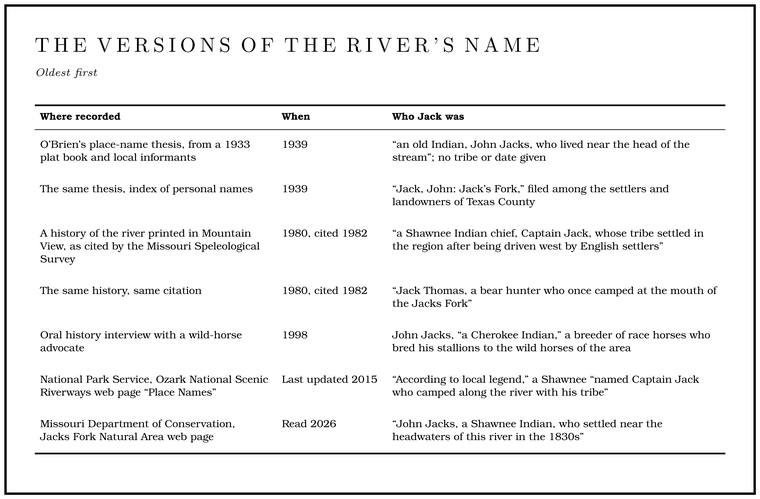
The river had its name by 1849, or by 1852 at the latestLewis 1980, PDF p. 11; Forte, Postal History, Texas County; O’Brien 1939, 67.. The earliest explanation found was written down in 1939, nearly ninety years later, and it puts Jack near the head of the river, in Texas County, the country of the Prong. A branch or arm of a creek, set down in 1860 as Southern usage. The North and South Prongs join to form the Jacks Fork (Chapter 18). Glossary →. No record from his own lifetime that names him has been found. That oldest telling gives him no tribe and no dateO’Brien 1939, 67., and the index that goes with it files him among the Texas County settlers and landowners rather than in its separate list of territorial figures and IndiansO’Brien 1939, 166, 175..
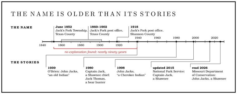
The later stories have more to them. The fullest telling of Captain Jack, from the 1980 history, begins on the Mississippi. The Shawnee and Delaware had been driven west by English settlers, and the Spanish, hoping to keep the English out of the country west of the river, encouraged them to settle in southeast Missouri. A Shawnee chief crossing the Mississippi on a ferry took a fancy to the ferryman’s hat, one like those the riverboat captains wore, and swapped him for it. The chief settled at last on the land between Little and Big Shawnee creeks, the pioneers called him Captain Jack, and the river became Captain Jack’s Fork of the Current River. The same history gives the other story. A bear hunter named Jack Thomas camped at the junction of the streams, and a panther got into his camp, ripped his gear and saddlebags apart and spooked his horses, and so the fork was named Jack’s Fork. Which story, if either, is true is hard to say, though the Indian one may have more substance, since Shawnee did live along the creeks that carry their nameLewis 1980, PDF p. 5 (“It is difficult to say which story, if either, is true. The Indian story may have more substance since Shawnee Indians did live in the Shawnee Field”; the field lies between the two creeks, PDF p. 74), the only source for both stories in this form; the judgment is the 1980 writer’s.. A cave survey report of 1982, retelling both, put the bear hunter’s camp at the mouth of the Jacks ForkMSS 1982, 1, citing Lewis 1980, whose “junction of the streams” could mean the mouth or the meeting of the prongs..
The race-horse story came out of the long fight over the wild horses of Shannon County (Chapter 11). Interviewed in 1998, a lawyer who had worked to keep the herd said its defenders had found “different documentation” about John Jacks, a Cherokee for whom the river was named. He was a breeder of race horses, by this account, who started straight-track racing and bred his stallions to the wild horses of the country, which helped show that horses had run loose there for a very long timeKennedy 1998, 10 (“We also had different documentation about John Jacks, who was a Cherokee Indian that the Jacks Fork River is named after. He was a breeder of race horses. He started straight track racing”; “So there have been wild horses around for a long, long time in that area”), the only source; the interview was recorded at Douglas R. Kennedy’s law office in Poplar Bluff (Kennedy 1998, title page). See Chapter 11..
The tribe and the decade appear only in these later tellings, and they disagree, Shawnee in some and Cherokee in another. Captain Jack first appears in writing in 1980, forty-one years after John JacksLewis 1980, PDF p. 5; O’Brien 1939, 67.. The old Indian of 1939 lived near the head of the stream in Texas County, while the chief of 1980 settled by the Shawnee creeks a little east of EminenceLewis 1980, PDF p. 5; Stevens 1991, 19., in the river’s last miles, and the bear hunter, in the 1982 reading, camped at the mouth itself.
The dates in the later tellings are awkward. The Shawnee and Delaware gave up their last Missouri claims in 1832, and Anderson’s Delaware were in Kansas by 1831Kappler 1904, Treaty with the Shawnee, etc., 1832; Stevens 1991, 19., so a Shawnee man who settled at the head of the Jacks Fork in the 1830s would have been staying on after most of his people had gone. Some did stay, as the Shawnee and Delaware whom Gillis traded with in the hills did, and more Shawnee may have passed throughStevens 1991, 19. the Ozarks after the Delaware left, since many had not given up their Ohio homelands until the early 1830s. No document places one at the headwaters. Nothing in the record settles whether Jack was Native, a white settler or hunter, a man of both worlds like Gillis or Kelley, or someone else entirely. Streams in this country were named for every kind of person. Alley Spring takes its name, by way of the post office of 1884, from John Alley, it is presumedPerry [1978], sec. 8; see Chapter 5 and Reach H., a farmer who lived about three miles east (an older account has him a pioneer who came before the Civil War and built a millO’Brien 1939, 2–3. on the river). Mahans Creek, spelled Mahon in the 1930s, was named for a family who lived at its headO’Brien 1939, 80..
The John Jacks tradition belongs to the river’s story as tradition, with its oldest form kept apart from the later additions, and who Jack was remains an open question (The Open Ledger). The likeliest places to find him are the land and agency papers of the 1830s and 1840s, the General Land Office field notes and Texas County land entries for the townships at the head of the river, the original slips of the 1930s place-name survey, kept with the State Historical Society of Missouri at Columbia, which may name the informantRamsay Place Names File, 1928–1945, State Historical Society of Missouri, collection C2366 (see O’Brien 1939 in the Bibliography); O’Brien 1939, 67, names three informants for the entry without saying which told the story. who told the John Jacks story, and the histories that the Shawnee, Delaware and Cherokee nations keep themselves.