The first American families came up the Jacks Fork in ones and twos during the 1820s and 1830s. They came by way of the Current River and settled where a spring, a Terrace. A level bench above a river, the remains of an older floodplain left high when the river cut down (Chapter 2). Glossary → above the floods and open woods for the stock lay close together. Few of them bought the ground they lived on. By 1840 the land office had recorded three entries in all of what became Shannon CountyStevens 1991, 43–44 (Table 2, after Clendenen 1973, 60)., and most families on the river held their fields by occupation and custom.
The households they made lasted a long time. A family lived on corn from a small fenced field, on hogs and cattle that ran loose in the woods, on game and furs, and on the trade of the nearest mill and storeStevens 1991, 28–30, 34.. Around those households grew a thin network of mills, schools, churches and post offices, each small, and each giving a neighborhood its name and a place to gather. About 1890 the railroads and the timber companiesStevens 1991, 72–75. arrived and changed most of it (Chapter 7). Some of it lasted much longer. The last Open range. The old rule that a farmer fenced his crops in and let his animals run on all unfenced land; also called free range. Shannon County kept it the longest in Missouri, until a state law of 1969 (Chapter 5). Glossary → in Missouri closed in Shannon County in 1969Rikoon and Albee 1998, 212, 220 n. 6..
Up the valleys
The southeastern Ozarks were settled from east to west, across the river valleysGibson 2000, 19, after Murphy 1982., and the Jacks Fork was reached by way of the Current, its parent stream. The newcomers moved into country that Delaware and Shawnee families had only just left (Chapter 4), and some of them probably knew the river first through the Indian trade. Across the southern Ozarks, squatters followed the departing eastern tribesStevens 1991, 28, after Morrow 1981. and took over the clearings and buildings they left behind.
In 1811 the American frontier stood about sixty miles west of the Mississippi, at the edge of the rough country now called the Courtois Hillsthe regional name is Sauer’s (Sauer 1920, 68)., the deeply cut land of the Current and Black rivers and their Branch. A small creek. The sense is American, on record from 1674 (Chapter 18). Glossary →. People came into that interior slowly, a family or a few families at a time, and it saw no period of fast growth, nothing like a boom, until after the Civil WarSauer 1920, 148 (the settling of the interior as “gradual and unobtrusive infiltration,” with no rapid growth except after the Civil War and “nothing that may be called a boom”)..
The people who came were overwhelmingly from the upland South. Before 1850, nearly all who moved into the southern Courtois Hills came by one of three routes: a central one from Kentucky and Tennessee, a northern one from Illinois and Indiana, and a southern one from Alabama and Arkansas. Most who traveled the northern and southern routes had been born somewhere else. Three-quarters of the adults who arrived in the 1840s were natives of Kentucky, Tennessee, Virginia or North Carolina. Tennesseans and Kentuckians made up about two-thirds of the population in 1850, and many of the Tennessee families came from the country between the Tennessee and Cumberland riversStevens 1991, 24, after Clendenen 1973.. Most were native-born Scotch-Irish uplanders, people of the scattered hill farmsHughes, Williams and Stevens 1992, [2] (a Park Service description). of Tennessee, Kentucky and North Carolina. The name goes back to the Lowland Scots who were settled in the north of Ireland in the 1600s and whose descendants crossed to America in large numbers in the next century and worked their way down the Appalachian valleys. Their home country, the upland South, was the most thinly peopled farm country east of the Great Plains, with the fewest villages and townsHughes, Williams and Stevens 1992, [2] (“the lowest population density of any rural area east of the Great Plains and the fewest villages towns and cities”)., and they brought that way of living with them.
Few came straight. A Howell County pioneer traced his family from Ireland to South Carolina, then to Alabama, Tennessee, Illinois and Arkansas before Missouri, “drifting with the stream courses.” Families moved together and settled together. Nearly two dozen Chiltons came to the southern Courtois Hills in all, many of them by the early 1840s and most from counties on the upper Tennessee RiverStevens 1991, 31–32, quoting Clendenen 1973, 28–29., and several became leading men of the river country. By one family account the head of the clan, Thomas Boggs Chilton, was born in Maryland in 1782, grew up in Tennessee, fought in the Creek War under Andrew Jackson and came to New Madrid County in 1816. In Shannon County he ran a sawmill at Owls Bend on the Current and rafted lumber down to Devall’s Bluff, in Arkansas, where the settlements of the timberless lowlands needed it, and he was remembered as one of the roughest and meanest men in the country. His sons Thomas J., Andrew, Joshua and Shadrach settled up the Jacks Fork from him, Thomas J. on the land where Eminence now standsLewis 1980, PDF p. 71, the only source for the family account (“Thomas Boggs was known as one of the roughest and meanest men in the country”).. A census taker went from house to house along the roads and trails, so the names that follow one another on his sheets are usually those of neighbors. The census taker in Shannon County in 1850 recorded heads of households in runs of shared surnames: Crabtree, Crabtree, Lewis, Summers, Summers, Summers, Lewis, McDonald, Lewis; and elsewhere in the county Suggs, Rogers, Thomas, Suggs, Chilton, Thomas, Chilton, Thompson, Chilton, Conway, ConwayStevens 1991, 32, after Clendenen 1973, 30. Neither source says where in the county those neighborhoods lay.. The same census counted nine enslaved people in Shannon County, against eighty-six in Ripley CountyStevens 1991, 30, citing the 1850 census., which then took in the lower Current and its larger plantations.
The first neighborhoods
By 1840 a few settlers lived at the mouth of the Jacks Fork, and in the 1850s someone built a small store there. Upstream, two pockets of small farms had formed (Map 5.1). The first ran from Shawnee and Little Shawnee creeks up to the site of present Eminence. The wide terraces near the mouths of the two creeks drew the most families. A Colonel Thomas Chilton farmed at the mouth of Shawnee Creek, the Fursman Spring Mill stood on Little Shawnee, and the Thomas and West families settled between the creeks and on the far bank of the river. Other homes stood on both sides of the river near the future town. Members of the Chilton family on these terraces ran large commercial farms and added copper miningStevens 1991, 31. to them.
The second pocket lay around Alley Spring. James McCormack, one of the earliest American settlers on the Jacks Fork, probably came there in the 1820sStevens 1991, 27. (Reach H).
The upper river and the Prong. A branch or arm of a creek, set down in 1860 as Southern usage. The North and South Prongs join to form the Jacks Fork (Chapter 18). Glossary → filled later, though by one account about a hundred families lived on the upper Jacks Fork by 1840. James Pickett was probably the first settler on that part of the river, and Jacob House, Samuel Rose, Ryle Williams and the Mahans were among the first to follow. A story from those years, told in Chapter 4, tells of a party of hunters from the Eleven Point country who came back to their camp on the upper river to find their camp keeper, an old man named William R. Smith, a veteran of the Revolution, killedLewis 1980, PDF p. 14, the only source; see Chapter 4.. A settler named Helm, pronounced locally and recorded as Hellum, lived by a spring in Barn Hollow before 1852. “Uncle Dick” Smith was living in the hollow when Isaac Winningham came to nearby Panther Hollow in 1852 or 1853Pottenger 1945, Howell file pp. 4, 46.. William H. Goldsberry, a Baptist preacher from North Carolina, settled in 1856Pottenger 1945, Howell file p. 41. on the site of present Mountain View, and John J. Campbell and John Goldsberry each took up land there around 1860Pottenger 1945, Howell file p. 15.. William PadgettPottenger 1945, Howell file p. 81., a Tennessean, owned land southwest of the future town before the Civil War. In Texas County, Reuben HarlowO’Brien 1939, 57. was remembered as one of the earliest settlers, and Jesse and Thomas Summer, early settlers at the townsiteO’Brien 1939, 130., gave their name to Summersville.
The river already had its name on county papers. In June 1852 Texas County created a Jack’s Fork Township out of part of Carroll Township, or by another record out of the part of Texas Township southwest of Spring Valley. Its first justices of the peace were Lamech Thorpe, A. J. Smith, Samuel Rose and an R. Harlow, probably Reuben, and James Pickett was one of its first judges of electionGoodspeed 1889, Texas County, “Townships” (the election at the house of J. Feur). That the R. Harlow was Reuben is a guess.. The Township. A survey square of six miles on a side, holding thirty-six sections; also a division of a county, such as Jack’s Fork Township (Chapter 5). Glossary → was renamed PierceO’Brien 1939, 67, 102., and a post office that kept the river’s name had opened in December 1849, or in 1860Lewis 1980, PDF p. 11; Forte, Postal History, Texas County; O’Brien 1939, 67. by another record (Chapter 4).
Counties and a courthouse in the woods
Three counties divide the Jacks Fork, and their lines still decide which courthouse a river landowner answers to.
Shannon County was created from part of Crawford County by an act of January 14, 1837Newberry Library, Atlas of Historical County Boundaries (Missouri chronology, Crawford County, January 14, 1837, citing Mo. Laws 1836–1837, 54–55); Gibson 2000, 18., organized as a separate county in 1841, and named for George Shannon, a member of the Lewis and ClarkO’Brien 1939, 119; Stevens 1991, 51. expedition. Shannon had been the youngest man of the party, a Pennsylvanian still in his teens when he joined in 1803. In the late summer of 1804 he went after two strayed pack horses, got ahead of the boats and was lost for sixteen days, living for most of them on grapes and a single rabbitMoulton 1987, entries of August 26 and September 11, 1804; Lewis 1980, PDF p. 69 (sixteen days; “wild grapes and one rabbit for 12 days”; Lewis makes him nineteen). before the expedition caught up with him. On a later trip up the Missouri, in 1807, he was shot in a fight with the Arikara and lost a leg, and he was known afterward as Peg Leg ShannonJackson 1978 (Ensign Nathaniel Pryor to William Clark, October 16, 1807, on the fight at the Arikara villages); Lewis 1980, PDF p. 69 (“better known as Peg Leg Shannon”).. He studied law in Kentucky, served in its legislature, moved to Missouri, and died at Palmyra in August 1836Jackson 1978 (biographical notes on the members of the party); Lewis 1980, PDF p. 69 (he died in Missouri in 1836). Page numbers in Moulton 1987 and Jackson 1978 were not checked., a few months before the county was created and given his name. It was larger then. By one account the first Shannon County took in the eastern third of present Texas County, the southern third of Dent, nearly all of Reynolds and a corner of Carter, though none of the country south of where U.S. 60Lewis 1980, PDF p. 69, the only source. now runs. In 1845 Reynolds County took its eastern partGibson 2000, 19; Stevens 1991, 51. along the ridge between the Current and the Black. The county seat, founded the year the county was organized and also called Eminence, stood on the Current RiverStevens 1991, 26, 33. well north of the Jacks ForkGibson 2000, 18–19.. By one account its site was fixed in April 1843, when three commissioners met at the house of Andrew McCain, where the court was then held, and chose a place on the Current near the middle of the countyLewis 1980, PDF p. 69 (Samuel Hyer of Crawford, West Mandling of Ripley and Joseph M. Stephenson), the only source. as it then lay.
The first Eminence was a seat of government and nothing else. Archaeologists from Southwest Missouri State University tested the site in 1980, and a University of Nebraska field school excavated it in 1983. They found the foundation remnants of a building about thirty-four feet by twenty-two, much like the 1839 courthouse that still stands at Arrow Rock, and a large depression with a compact clay floor that they identified as the jail. Charred floor planks and a charred beam lay where they had burned. Window glass, cut nails, whiteware and a few decorated dishes, bottle glass, door hardware and buttons turned up around the two buildings. No other buildings or activity areas of the period were found, nor any trace of a house, a store or a tavernNRHP, Old Eminence 1985, sec. 7., and no other county seat standing alone in the woods like this one is known in the eastern Ozarkssame, sec. 8 (“the only identified isolated political center in the Eastern Ozarks”).. Union soldiers who camped there in February 1863 found the two log buildings and nothing else, and joked that the lawyers had to travel five miles for their suppersStevens 1991, 58 (“only two log buildings, a courthouse and jail”), after Bradbury’s notes on the Army of Southeast Missouri.. Everything else a county seat usually held was scattered through the neighborhood. A mill and at least one house stood across the river, the post office was kept in the postmaster’s home a quarter mile away, and the Deatherage store, about four miles downstream, served families from as far as fifteen milesStevens 1991, 37.. A Union regimental history published in 1902 said of the place that it “was evidently not named for what it then wasElliott 1902, 34, as quoted in Brown 1969, 13 n. 11., but for what it expected to be.” The courthouse burned during the Civil WarNRHP, Old Eminence 1985, sec. 7; O’Brien 1939, 42–43. (Chapter 6).
Texas County was created by an act of February 17, 1843, as Ashley County, after the fur trader William Henry Ashley. An act of February 14, 1845O’Brien 1939, 132., renamed it for the Republic of Texas. Its first county court met at Ellsworth on April 21, 1845, and in June 1846 the court gave the name HoustonGoodspeed 1889, Texas County, “Establishment” (the court later sat at the house of David Lynch, one of the first judges, until September 1846). to the new county seat. Houston was incorporated in 1847O’Brien 1939, 62.. The Jacks Fork rises in itO’Brien 1939, 67..
Howell County was formed on March 2, 1857, out of Oregon and Ozark counties. Thomas Jefferson Howell, who represented Oregon County in the legislature, worked to organize it, and it was named for the early settlers of Howell Valley, where his father, Josiah Howell, settled about 1840; Josiah was considered the first permanent settlerPottenger 1945, Howell file pp. 1, 50–51. within the county’s present limits. Its seat is West PlainsPottenger 1945, Howell file p. 112.. Goldsberry Township, in the northeastPottenger 1945, Howell file pp. 4, 41, 81. corner of the county, drains to the upper river through Barn Hollow and Panther Hollow.
Lines on the land
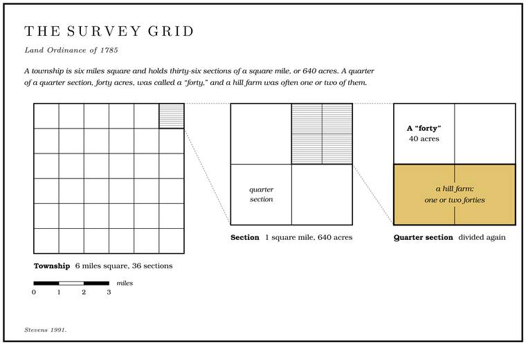
Federal surveyors measured the Jacks Fork country before most of it could be sold. A township plat around Alley Spring dates from 1821Zedeño and Basaldú 2003, 82; Finney 2006, 56., surveyors’ notes for much of the basin date from the 1830sJacobson and Primm 1994, 15–16., and the land near Eminence was surveyed in 1840Bridge 1930, 171.. They worked on the national grid laid down by the Land Ordinance of 1785, which required survey before sale and divided the land into uniform townships and Section. A square mile of 640 acres, one thirty-sixth of a township. A quarter section is 160 acres (Chapter 5). Glossary →Stevens 1991, 41.. A township is six miles square and holds thirty-six sections of a square mile, or 640 acres. A quarter of a quarter section, Forty. Forty acres, a quarter of a quarter section. A hill farm was often one or two forties (Chapter 5). Glossary → acres, was called a “forty,” and a hill farm was often one or two of themStevens 1991, 28.. The surveyors measured with a chain sixty-six feet long, eighty chains to the mile, and set a post at each section corner and at each half mile between. At every corner they marked two or more nearby trees as witnesses and wrote down the kind and size of each and its distance from the post. Along the line they noted the timber and the undergrowth, the lay of the land, the soil, and each stream they crossed.
Those field notes are the earliest close description of the valley, and they describe a different country. The eastern part of the basin was mostly mixed forest of hardwoods and evergreens. The western half was hardwood forest, which the surveyors usually called “thin.” In the southernmost part of the basin they found brush, oak savanna and barrens. A savanna is open woods, big trees standing apart over grass, and in the surveyors’ usage barrens were open, scrubby uplands with few trees of any size. Every acre of evergreen forestJacobson and Primm 1994, 15–18 (Table 3). they mapped had become hardwood by the 1970s. Older settlers on the upper river remembered the same openness. In Barn Hollow the valleys were said to have been “practically barren of timber during the early days,” and around Mountain View large timber was scarce, so that a person could see a long way over the hills and valleysPottenger 1945, Howell file p. 73.. A Howell County pioneer recalled that in 1844 the table lands “had very little timberSauer 1920, 54–55, quoting Monks 1907, 7–8. growing on them, but were not prairie,” with brush and post oak runners and a heavy turf of grass.
For decades almost nobody bought land from the government (Table 5.1).
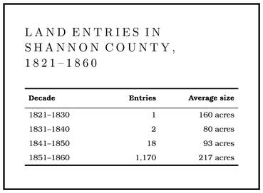
Many names on the early census never appear on a deedGibson 2000, 19, after Murphy 1982., a sign that squatting was common. A squatter held his cabin, his fences and his cleared ground only so long as nobody else bought the land under them, and in these hills few buyers came for decades. One of the first entries in the Jacks Fork country was bought for what lay under the ground. On April 8, 1841, the land office at Jackson issued a certificate for a quarter section east of Eminence to a James Thompson, who transferred it the same day to John Epps CowanBridge 1930, 171.. It held the diggings of Slater’s copper mine.
A change in federal law produced the jump of the 1850s. Since 1820 public land had sold for at least a dollar and a quarter an acre, in tracts of eighty acres or more, first at auction and then to anyoneStevens 1991, 41–42. who came to the land office afterward. Land that drew no bid at that price stayed on the market, and in the Courtois Hills most of it stayed there for decades. A pre-emption law of 1841 let a squatter buy his claim at the minimum price before it went to auction, though only once it was surveyedStevens 1991, 42.. The Graduation Act of 1854 went further. It lowered the price of public land according to how long it had gone unsold: a dollar an acre after ten years on the market, seventy-five cents after fifteen, fifty cents after twenty, twenty-five cents after twenty-five, and twelve and a half cents after thirty. A buyer could take no more than 320 acres and had to swear that he meant to settle and farm itStevens 1991, 42–43; Gibson 2000, 19..
Public land in the southeastern Ozarks had been on the market since the early 1820s, so nearly all of it qualified for the lowest price, and most buyers took the full 320 acres for forty dollarsGibson 2000, 19–20, quoting Murphy 1982, 71–72.. In the year ending June 30, 1858, the land office at Jackson alone sold 1,009,335 acresSauer 1920, 158. at twelve and a half cents and 85,999 acres at twenty-five cents, “largely in Shannon and other counties of the Courtois Hills.” An Ohio man hunting land in Dent County in 1856 found the rush already on: “Everyone seems anxious to enter all he can at the graduationStevens 1991, 44, quoting the diary of Henry Beeson Flanner, 1856 (Dent County)., and that out, they lay warrants and buy at $1.25.” The warrants were the bounty-land warrantsStevens 1991, 42 (the two military bounty acts). Congress had issued to veterans, which could be bought and sold and laid on any open tract. In Shannon County the number of entries rose from twenty-one before 1850 to 1,170 in the 1850s, and the average tract more than doubled. Families already on the land added to their holdings, and squatters bought the sitesStevens 1991, 44. they had lived on for years. Dr. Thomas Reed, Shannon County’s first doctor, who had come from Tennessee with his brother-in-law Thomas Chilton and settled on the Current in the 1830s, entered 700 to 800 acres under the act by 1856Stevens 1991, 44, after Little 1990..
Up the river in Texas County, in the township where Jesse and Thomas Summers took up land, the first entry was made by Julia Halbert on April 12, 1848, and the Summerses entered their land there on May 1. In the next township south, which takes in a stretch of the upper river, Greenberry Harlow entered land in 1853 and Elijah Lynch in 1858, and about 1858 a Jesse Eaton bought land on the Jacks Fork itselfGoodspeed 1889, Texas County, “Pioneer” (by township and range: the Summers and Halbert entries in T. 29 N., R. 7 W.; Harlow, Lynch and Eaton in T. 28 N., R. 7 W.). That the Eaton’s of 1864 was his is an inference; see Chapter 6., probably the Eaton’s where a Union patrol stopped in 1864 (Chapter 6).
Many of the new owners never saw the hills. In one township of neighboring Reynolds County, the censuses of 1860 and 1870 show that about nine in tenStevens 1991, 44, 46 (“more than 90 percent”); Gibson 2000, 20, quoting Murphy 1982, 71–72 (seven of sixty-seven buyers on the census). of the people who bought land between 1854 and 1859 were absentee owners. Many of the 320-acre tracts sold in Shannon County in 1859 and 1860 went to buyers from Massachusetts, New York and other northern and eastern states, among them agents of lumber and railroad companiesStevens 1991, 46; Gibson 2000, 20.. The railroad companies seem to have used Irish laborers from the St. Louis and Iron Mountain line, which then ran south to Pilot Knob, as buyers of record to get around the 320-acre limit, and an unusual number of Irish immigrants turn up among the landholders of Reynolds CountyStevens 1991, 46, after Murphy 1982, 71–72 (Murphy’s suggestion).. Speculators took up the rough hillsStevens 1991, 44., and the families who lived on the land stayed in the valleys and hollows. Outside money kept coming after the war. In 1883 the Western Land and Cattle Company, founded and incorporated in London two years before, bought about 28,000 acres in Texas County, much of it along the North Prong, and tried a hog ranch there, which disease ruined. By 1885 it had cleared 125 acres and built a four-room frame house, and it leased the cleared land to its Scottish manager, Charles E. PeterGoodspeed 1889, Texas County, “Natural Features” (the company founded in 1881; “the Peter ranch is on Steiner’s Fork of Jack’s Fork”)., whose name went on the ranch and on Peters CreekLewis 1980, PDF p. 9; see Reach A. (Reach A).
After the war the Homestead Act of 1862 offered free land to anyone who would live on it. A settler could claim 160 acres of surveyed public land and, after living on it and farming it for five years, receive the title for a small filing fee. Isaac Winningham, who had bought forty acres in Barn Hollow from Richard Smith, homesteaded 160 more in 1869Pottenger 1945, Howell file p. 4.. Northern homeseekers from Indiana, Illinois, Ohio, Pennsylvania and New England took up the open prairies of the plateau, while many tracts of the stony upland soils had been entered only latelySauer 1920, 157, 159–60. The terms of the Homestead Act of 1862 are general history..
Copper on Shawnee Creek
One of the first industries on the Jacks Fork was a copper mine. Hunters and trappers found copper in what became Shannon County early in the century. Word reached the French settlements on the Mississippi about 1837, and a group at Ste. Genevieve that included members of the Vallé family and Henry Janis sent a Cornish miner named Joseph Slater to work it. Slater arrived in 1837 or 1838, before the land had been surveyed, and bought the right to mine from a hunter named George Smith, who claimed the deposits by right of discovery. He built a cabin on Shawnee Creek, east of present Eminence, and nearby a boarding house, a store and a blacksmith shopBridge 1930, 170.. A St. Louis newspaper in 1840 called the workings “the celebrated mines,” and the surveyors who came through that year marked the mine and its buildings on their platsBridge 1930, 171..
Slater’s men took the ore from shallow pits where the Dolomite. Calcium magnesium carbonate rock, a close relative of limestone, formed from lime mud on the floor of a warm, shallow sea. Nearly every bluff on the Jacks Fork is dolomite (Chapter 1). Glossary → met the old volcanic rock (Chapter 1). A geologist who saw the workings in 1841Hodge. The working of the furnace (blast, slag) is general metallurgy., after they had stopped, found the diggings about ten feet deep on average, though he could get no sure account of the deepest, said to be eighteen. Slater smelted the ore on Shawnee Creek in a furnace of quartz rock about three feet high inside and a foot square. A twelve-foot overshot water wheel, turned by the weight of water poured into buckets on its rim, worked the bellows, and the fuel was charcoal. Charcoal burns far hotter than raw wood when air is forced through it, and the bellows kept a steady blast in the little stack until the ore melted, the copper ran together at the Bottom. The flat land along a river or creek, built of its deposits and open to its floods. In the 1920s the bottoms near Eminence averaged about a quarter of a mile wide (Chapter 2; Chapter 5). Glossary →, and the lighter waste rock floated off as slag. The little furnace wore out fast and had to be pulled out and rebuilt about once a week. Miners earned twenty to thirty dollars a month and laborers twelve to twenty-fiveBridge 1930, 170–71, quoting J. T. Hodge’s 1842 account., with board, and by one account cleaned ore brought $54 a tonLewis 1980, PDF p. 73, the only source.. Slater’s output was later put at 1,500 tons of ore. By one mining report about 160 tons of pig copper, the metal cast in bars, had been made at the Shawnee furnace before 1874 and shipped by flatboat to New Orleans, though other reports gave 75 tons and whether all of it was Slater’s is not clear. Estimates of the copper’s value ran from $50,000 to $100,000Bridge 1930, 171 (citing C. P. Williams’s 1877 report for the state survey and an 1874 mine report by J. V. C. Phillips)..
Slater lost the land. He had bought only a hunter’s claim, and in 1841 the quarter section itself passed by land-office certificate to Cowan. Slater went to court, and the case went to the Supreme Court and was decided against him. He left the country. Cowan sold the property to Alexander Ferguson of a Scottish firm, the Aberdeen Mining CompanyBridge 1930, 170–72., which worked the mine for a short time in the 1840s and shipped some of its ore across the Atlantic to the smelters at Swansea, in WalesLewis 1980, PDF p. 73.. In May 1848 Thomas Primrose of South Carolina bought the mine for the Current River Mining Company of New York, which sank a shaft more than a hundred feet deep. In the summer of 1853 the company sent a Captain Bawden to examine it. He reported a vein “of most promising character,” about sixty tons of surface ore that could be washed and readied for the furnace, and an outcrop he had seen matched only at the Cobre mines in Cuba. He described the Jacks Fork as “navigable with float boats and rafts of timber the whole year,” with steamboats coming regularly from New Orleans to Doniphan, sixty miles below, and four housesLewis 1980, PDF p. 72, quoting Bawden’s report to William Warne (Bawden puts the shaft at 200 feet). already standing at the mine. By one account the company quit the mine in 1857, and by another it had $30,000 invested there in 1860. In 1872 the property went to the Consolidated Land Company of Missouri, in 1876 to Charles Biser of St. Louis, who shipped a few carloads of ore, and then to the Current River Land and Cattle Company, and in 1892 a 99-year lease on it passed in time to a Slater Copper Company of WinonaLewis 1980, PDF p. 72, the only source (the 1892 lessee was F. M. Rogers)..
Slater’s long fight in the courts set people talking, and the story grew that he had found a rich deposit and hidden it. By one telling the shaft was covered over with sod and two pine trees were planted on the spot. People kept hunting for it, and a woman of ninetyLewis 1980, PDF pp. 72–73, the only source. who had watched her father and other men come up out of the shaft as a girl was taken back to look for the place and could not find it in the brush. The government reserved seven Shannon County townshipsSauer 1920, 162. in the hope of a copper district, and copper ore was still among the exports of Eminence in 1876Stevens 1991, 70.. The mines were reopened during the First World War, when metal prices rose, and all were idle again by 1922Bridge 1930, 15, 172–73..
How a hollow farm worked
Choosing the place. A Howell County pioneer remembered that in 1844 “The settlements were confinedSauer 1920, 156, quoting Monks 1907, 7. to the creeks and rivers, where were found plenty of water and springs. No place at that time was thought worth settling unless it had a spring upon it.” Along the Current the settlers chose the terraces above the Floodplain. The flat valley floor that a river builds and floods (Chapter 2). Glossary →, which put water close at hand, stood above the floods, sloped gently enough to plow, and backed onto open uplandStevens 1991, 27, quoting Clendenen 1973, 57–58 (“easy access to water, immunity from flooding, gently inclined, tillable slopes, and an unlimited upland for grazing and foraging stock”). where stock could graze and forage without limit. The best farms of all lay on the Slip-off slope. The long, gentle slope on the inside of a river loop, left as the river slid away from its earlier positions (Chapter 2). Glossary →, the long gentle ground on the inside of a bend across the river from a Bluff. A cliff along the river, usually on the outside of a bend, where the river has cut sideways into the hill. In this sense the word was first used in North America (Chapter 2; Chapter 18). Glossary → (Chapter 2), with fields on the lower slope and grass on the upperSauer 1920, 24 (“invariably the sites of the choicest farms”).. On the Current, people had lived on some of the same terraces for thousands of yearsStevens 1991, 27–28., and the Jacks Fork terraces have their own long record (Chapter 3).
Almost nobody lived on the ridges early. The chert-covered soils were steep and hard to plow, and water was scarce except at a few springs and Sinkhole. A hollow in the ground where rock below has dissolved or caved in, through which water drains underground; also called a sink, an American use (Chapter 2; Chapter 12). Glossary → ponds, sinks whose bottoms had sealed with clay so that they held rainwater. Birch TreeStevens 1991, 27, 33., in the uplands of southern Shannon County, grew up around a group of those ponds.
The farm itself. On the upper Current and its branches a typical farm ran forty to eighty acres, with a few acres fenced for crops. In 1820 the cultivated fields averaged about ten acres, and by 1840 nearly twenty. Inside the fences grew mostly corn. Families planted two or more fields at different elevationsStevens 1991, 28–29., the hill field in early spring and the bottom field in late spring. In a wet year the hill corn might survive. In a dry year the hill corn burned up and the bottom field could still make a crop. Gardens held potatoes and other vegetables, and some tobacco and cotton, and next year’s seed hung from the rafters in gourds.
Most of what a household used was made at home. Families made clothing from buckskin, wool and cotton, tanned cowhides for shoes and harness, boiled soap from lye and fat, and mixed pine tarGibson 2000, 21–22, after Murphy 1982. with animal fat for salve and axle grease. A family often kept a single heifer, which gave the milk and carried loads, and sometimes people tooGibson 2000, 21, after Murphy 1982.. They pressed sorghum cane for molasses. The cane was crushed between rollers turned by a horse or mule walking a circle, and the green juice was boiled down in a long shallow pan over a fire until it thickened. In 1909 Texas County led Missouri in sorghum syrup, with 43,510 gallons, and in the remote hills sorghum was still the common household sweeteningSauer 1920, 197–98..
Meat in the woods. Hogs were the staple. An English geologist who traveled the southeast Missouri Ozarks in the 1830s complained of “the same disgusting coffee, pork, bread, and butter three times a day, as long as they live.” He also noticed that nobody kept hay meadows. The stock lived on corn leaves and on the forest’s mast, the acorns and nuts that cover the hillsides in fall. Left to forage, the animals needed little tending, and the men had time to huntStevens 1991, 29, quoting George W. Featherstonhaugh (Featherstonhaugh 1844, 81, 85).. A Texas County settler remembered that in 1841 the deer ran in large herds and that black bears, panthers, wolves and wild turkeysGoodspeed 1889, Texas County, “Natural Features” (John T. Lynch’s recollection). were common. About 1915 one hill farmer sold $500 worth of hogs that had been fed twelve bushels of cornSauer 1920, 186 (“a typical case”). in all.
Furs for money. Settlers hunted more for hides than for meat. Bear oil, hides, pelts, feathers, ginseng and other herbs passed as currency and were traded at country stores for coffee, sugar, saltStevens 1991, 29–30; Gibson 2000, 22., gunpowder, tobacco, dye and whiskey. In Howell County, one pioneer wrote, “beeswax, peltry and fur skinsSauer 1920, 151 n., quoting Monks 1907, 8–11. almost constituted the currency of the country,” and taxes were commonly paid in skins. The pioneer described a tax collector’s horse “completely covered with fur skins so you could see no part of him but his head and hoofs and tail.” The account books of the Deatherage store in the 1850s show customers credited for pelts and rootsStevens 1991, 105.. As late as 1884Stevens 1991, 103. the trade of Eminence was in pelts, furs and roots.
The house. Neighbors raised log houses together. A favored plan was the Dog-trot. A house of two log rooms under one roof with an open hall between them, where tools and saddles were kept and the hunting dogs slept (Chapter 5). Glossary →, two log rooms under one roof with an open hall between them, where tools, saddles and firewood were kept and the hunting dogs sleptGibson 2000, 22, after Oakley 1970.. Another was the double-pen house, two rooms side by side with a door into each, giving the front a window, door, door, windowStevens 1991, 130; Gibson 2000, 22. pattern that is still the commonest old house form in the Ozarks. One old house on the lower river broke the pattern. Joshua Chilton’s house, added to over the years and torn down shortly before 1980, was remembered as a fine log cabin, and when it came down its original logs turned out to stand upright, set side by side in the French manner, instead of being laid one on another in the usual way. By one guess the Chiltons had moved into a cabin that Shawnee or Delaware familiesLewis 1980, PDF p. 71, the only source (“Legend told that it was a fine log cabin. It turned out to be made of logs standing upright”; the guess about its builders is Lewis’s)., who had learned the upright style from the French, built before them. In 1914 and 1915 the houses of the interior were still lowSauer 1920, 206. and many were still of logs, from crude cabins to timbers squared and fitted so closely they hardly needed chinking, with long built-in porches “of the old South.” Hickory chairs and walnut bedsteads were in common use, and a few households still carded their own wool and spun it into thread. Barns on the hill farms were poor sheds, since little hay was cut and the stock found its own shelter. Rail fences were almost universal, and corn went into log cribs or stood in the field. The spring served as the cellar. “Most cove farmers keep their butter and milk in the cavernous openings from which springs issue,” wrote a geographer who traveled the hills in those yearsSauer; his travels of 1914 and 1915, Sauer 1920, ix..
Neighbors. Hill families raised barns in a day and ended with a supper and a dance. They held logrollings to clear fields, quilting bees for a new wife or mother, and shivarees to test the hospitality of a new groom, and the men tested their aim by “barking” squirrelsGibson 2000, 22., stunning them with a bullet in the bark just below the head. Custom bound neighbors “to aid and assist in helping any person who met with any misfortune in the way of sickness, death or other causes.” Neighbors nursed the sick, made the coffins and buried the dead on the home place in a winding sheetGibson 2000, 23, quoting Monks 1907, 12, and after Murphy 1982..
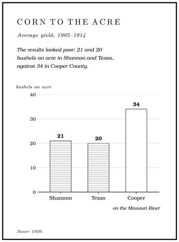
Making a living. Nobody on the river lived by farming alone. The early households herded, hunted, farmed and tradedStevens 1991, 28., and in the hills of the 1910s one man might still be a crop farmer, a stock raiser, a tie cutter, a miner and a teamster by turnsSauer 1920, 234 (“One man may be alternately crop farmer, stock raiser, tie cutter, miner, and teamster”).. Measured by the census, the results looked poor. In 1910 only ten percent of Shannon County was improved farmland, against thirty percentSauer 1920, 178. in Howell, and the county’s land was valued at $9.94 an acre, the third lowest in MissouriGibson 2000, 26, after Murphy 1982.. From 1905 to 1914 corn averaged twenty-one bushels an acre in Shannon County and twenty in Texas, against thirty-fourSauer 1920, 191–92. in Cooper County on the Missouri River. A hog from the oak forests of Shannon was worth $4.20 in 1909, and one from Cooper $7.60Sauer 1920, 186.. In 1896 Joshua Sholar, editor of the Eminence Current Wave, scolded that “The majority of farmers of Shannon County do not farm for a profit, while a great many more farm with a rifle and a pack of hounds.” He urged them to manure their fields, raise more wheat and corn, grind it at AlleyStevens 1991, 125, after Flanders 1979. and sell the meal or flour at Fishertown.
Much of what the hills produced never reached a market. In 1910 the farms of the southeastern Ozark counties produced about $7.2 million worth of goods, and only about $2 million of it was soldGibson 2000, 23 ($7,161,410 and $1,959,840, for the farms of the southeastern Ozark region in 1910, after Murphy 1982), 26–27 (the reading of such figures as a household strategy of many sources).. A family that ate from its garden, its stock, the woods and the river, and took wages when wages appeared, had many sources to fall back on when one failed. Families who had turned wholly to wages were the ones left without work when the timber companies moved on.
Fences around the corn
Fence the crops. The settlers brought from the upland South an old rule: a farmer fenced his crops inStevens 1991, 29. and let his animals run. Whatever lay outside a fence was open range, and an animal that wandered onto unfenced ground was where it had a right to be. A woman who farmed on the South Prong from the 1930s put the rule from the other side: “The thing that’s wrong with free rangeJacobson and Primm 1994, 46 (a woman who farmed on the South Prong from the 1930s). is you have to fence to keep things out. You don’t fence to keep them in.” Until the 1890s raising stock was the most profitable business in many hill counties. Cattle grazed the unclaimed public land, the habit of burning it in the fall “made grazing good even in the timber,” and some owners drove their cattle south to the Arkansas canebrakesSauer 1920, 160–61. for the winter. Hogs fattened on mast. As late as 1914 and 1915, across most of the hill country, whatever land was not under fence was free to anybody’s stockSauer 1920, ix (the travels), 185.. In the 1920s much of the rough land along the rivers near Eminence was still open range, where cattle brought in from the south and southwestBridge 1930, 25. spent the mild winters.
The system had its rules. Each owner had a mark, a pattern of notches or Hole. Any pool deep enough to swim or fish in, named or not, the basic unit of the river in local speech; also “hole of water” (Chapter 18). Glossary → cut in an animal’s ear, recorded at the courthouse, and stock was marked in early spring and then left alone, except for an occasional salting, until winter. Bells hung on the leaders of a herd so that a farmer could find his animals, and they could be heard nearly everywhere, even in the most isolated woods, on cattle, horses, sheep and turkeysSauer 1920, 186.. Hogs were managed the same way. A family turned out a sow or twoJacobson and Primm 1994, 46 (a woman born in the upper basin in 1935)., notched the ears of the litters, and gathered them in the fall, and as a woman born in the upper basin in 1935 explained it, “if they come with your sow, they were yours.” A woman who grew up on a 160-acre farm in the Shannon or Carter County hills remembered neighbors riding by to ask, “Have you seen my cattle lately?” A milk cow that wandered off with a herd might come in days later unmilkedGibson 2000, 35–36., and whoever found her milked her and sent her on.
People who lived on the upper Jacks Fork between the 1910s and the 1940s remembered the rangethe interviews published in Jacobson and Primm 1994, 12, 39–40 (Table 6 gives the narrators’ birth years and homes). well. A man born on an upper-basin farm in 1904 said the family would milk the cows “and just kick them out the gate,” and that out on the free range “there’d be as high as 50 bells. You could just hear cow bells.” A man who put his cattle’s salt out at the mouth of Johnny Hollow near Rymers said his cattle “ran from there to Alley.” A man who grew up on the Current near the mouth of the Jacks Fork said “It was nothing to see 40 or 50 headJacobson and Primm 1994, 54. of cattle in the river.” Hogs wore “big, deep ditches”Jacobson and Primm 1994, 46. in the banks where they went down to the creeks. When it came time to sell, families penned their hogs and fed them corn, because acorn-fed fat stayed soft, and a woman whose family came to the upper basin in 1911 remembered that acorn meat “had a wild taste” but would not put on weightJacobson and Primm 1994, 45 (a woman whose family came to the upper basin in 1911).. Horses ran loose too, and the wild horses near EminenceRikoon and Albee 1998, 212. are tied in local memory to the open range (Chapter 11).
Setting the woods afire. Burning went with the range. Native people and the early hunters had fired the grass to improve the grazing for game and to drive game toward the huntersSauer 1920, 53–54., and the settlers kept it up for pasture. In living memory the fires came in spring, when a fast fire through the woods took off the winter’s dead leaves and grass and let the new grass growJacobson and Primm 1994, 46 (burning “would take the litter off, stimulated the grass to grow”).. A man born at Alley Spring in 1907, who spent his life farming and running a portable sawmill, described the bluestem that came up after a burn as good grazing until it grew tall and toughJacobson and Primm 1994, 45 and Table 6, 39. and the stock would no longer eat it. Neighbors went out in bunches to rake a line around one man’s farmsame, 44–45 (the man who grew up on the Current near the mouth of the Jacks Fork). and burn around it, and then around the next farm close by, and families that did not care to burn the woods themselves still burned around their own places so that a fire coming from somewhere else would not take their fences and haysame, 46 (the man whose family came to the basin in 1932).. People on the upper river remembered it the same way:
- “We used to always burn every spring,” said the man born in 1904.
- Another gave the season as “Last of February, first of March.”
- A man who came to the upper basin in 1951 said “Easter Sunday was the big day for burning.”
- A woman who grew up on a North Prong farm remembered that her mother burned the ridges and “she’d go down the cricksame, 46. and burn all the leaves.”
- “Every spring you could depend on burningsame, 46. all over the country,” said a man whose family came to the basin in 1932.
Not everyone burned. Near Bay Creek, a sawyer remembered, people held back because “they didn’t want to spoil their hog feed.” The people who lived through it disagreed about what burning did. A man who had farmed the upper basin all his life saw no erosionsame, 46. from it, and remembered woods so open that “You could see a horse up there on that hill.” Another said “Yes they had erosionsame, 45., yes, yes, yes. We had a lot, we had big floods.” A third remembered woods that were “rocks and bare,” and ground rooted by hogs until “it looks like they’ve plowed.” Their accounts bear on the gravel in the river (Chapter 15) and on the fire history of the forest (Chapter 16).
The end of the range. A century of free grazing changed the woods. The bluestem the first settlers prized could not stand the close grazing, and where the grass fires let up, oak sproutsSauer 1920, 161, 185. moved in. When national forests were proposed for Missouri in the late 1920s and 1930s, many people in the Ozarks feared they would end spring burning and open grazingStevens 1991, 196–97.. On the national forest lands, the Forest Service’s fire prevention work soon cut the share burned each year from about a third to about one percentStevens 1991, 204..
Closing the range took longer. A Stock law. A local law that made each owner answer for his animals wherever they went, so that stock had to be fenced in. Stock laws closed the open range township by township (Chapter 5). Glossary → turned the old rule around and made each owner answer for his animals wherever they wentSauer 1920, 185 (“Stock law, which makes the owner responsible for all unconfined stock”)., so that the cattle had to be fenced in and the crops no longer had to be fenced against them. Missouri left the stock law to local vote. Under the law of the 1930s the county court called a stock-law election on a petition of the voters, and where a stock law carried, horses, mules, asses, cattle, swine, sheep and goats could no longer run at large, and a constable might take upMissouri Attorney General 1939 (a Butler County case under R.S. Mo. 1929, sec. 12805, in which a constable who threatened to take up loose stock after a void election was enjoined). stock found loose. In the Jacks Fork basin and its neighbors the range was voted closed township by township through the 1940s, 1950s and 1960s. As each township closed, farmers began fencing, clearing, seeding and fertilizingJacobson and Primm 1994, 47. pasture of their own. A woman who lived on the North Prong in Texas CountyJacobson and Primm 1994, 39 (Table 6: a farm on the North Prong of Jacks Fork); the North Prong lies wholly in Texas County (see Part Five, Reach A). remembered, “Two years after we were marriedsame, 45. they voted the stock law in.” Her family went to barbed wire, and she knew why many neighbors hated the change: they had more cattle than their own land could carry, and “Most people just had 80 acres.” Shannon County voters turned down every proposal to close the range. In 1969 the legislature prohibited local-option stock laws and made the closed range the rule for the whole state, so that an owner could no longer let his stock run outside his own fences and answered for the damageMatthews [1976] (“In 1969 the ‘open range’ law was changed by the Missouri legislature to a ‘closed range’ system”). if they got out. That ended open range, and Shannon was the last county in MissouriRikoon and Albee 1998, 212, 220 n. 6; Stevens 1991, 205. to give it up. By then the Jacks Fork was a national riverway. A man who ran cattle between Rymers and Alley said that the bottoms, once kept open by the stock, had “growed up and you can’t hardly walk throughJacobson and Primm 1994, 53. a lot of it,” and another said of the old farms, “since they bought thissame, 55., the Scenic River bought it, it’s closed up.”
Mills on the branches
Grinding at home. Corn had to be ground, and a family far from a mill did it by hand. In 1834 a traveling English geologist watched a family that “had no mill of any sort to go to” pound corn in a hollow scooped out of a large stump. A wooden pestle eight feet long hung over it from a curved pole sixteen feetStevens 1991, 33–34, quoting Featherstonhaugh 1844 (Stevens’s notes give pp. 73–74 and Clendenen 1973, 74). long with a heavy weight at the end, and a cross stick through the pestle served as the handle (Fig. 5.2). The weighted pole lifted the pestle after each blow, so the work went into the downstroke.
Water mills. As soon as a neighborhood could support one, someone dammed a Spring branch. The stream that runs from a spring to the river, such as the branch below Alley Spring (Reach H). Glossary → or a creek. Mill sites were plentiful. The big springs gave steady power, seldom failed in a drought or washed out in a flood, and usually gave more than a mill could useSauer 1920, 162 (the region “is unusually well supplied with mill sites,” and its springs “afforded splendid power for driving primitive water wheels”).. The earliest mills were probably “Norse” mills, a type common in hilly country, in which the water struck a small horizontal wheel at the foot of an upright shaft, and the shaft turned the upper millstone directly with no gears between. Bigger mills used an upright wheel, and where the fall was high enough an Overshot wheel. An upright water wheel fed at the top, turned by the weight of water in its buckets (Chapter 5). Glossary →, filled at the top so that the weight of the water turned it. The miller often ground for a fee or a share of the meal, for neighbors who used all their corn at homeStevens 1991, 34, after Clendenen 1973, 74. How the Norse and overshot wheels worked is general..
Before 1860 at least ten gristmills and six sawmills worked in the Current River valley, and at least three more on the Jacks Fork. The Fursman Spring Mill stood on Little Shawnee Creek east of Eminence, though by one account the spring took the Fursman name later, from a family who lived there during the DepressionLewis 1980, PDF p. 79 (the Fursmans “lived there during the Depression”; a cabin of 1861 stood “near what is now called the Fursman Spring”), the only source; see Reach J. (Reach J). The McCubbin Mill, whose site is given two waysLewis 1980, PDF p. 19 (on the spring branch in McCubbin Hollow) and PDF p. 24 (map: on the river a little below Belew Hollow); see Reach D. (Reach D), and the Stoops grist and sawmillStevens 1991, 34. stood farther west toward the headwaters. A Union column in November 1863 marched “by way of McCobbin’s Mill to Spring Valley,” probably the same mill (Chapter 6). The official counts run lower than the mills known from other records. The census of 1860 found two mills in all of Shannon CountyGibson 2000, 23, after Murphy 1982, 88; compare Stevens 1991, 71 (five water mills in Carter, Shannon and Ripley counties).. In 1874 there were again two by one count, one at Rocky Falls and one built about 1869 at the big spring then called Mammoth Spring and later Alley. Its water wheel turned under a rough shed, with a dam about a hundred feet below the spring. Charles Klepzig bought it in 1881, and George W. McCaskillPerry [1978], sec. 8 (an 1874 account). built the Roller mill. A mill that grinds grain between steel rollers. Alley Mill, finished in 1894, is one (Reach H). Glossary → that still stands there (Part Five, Reach H).
Other mills came and went. Nicholl’s Mill, in Eminence Township, belonged to a veteran of the War of 1812; it was known in 1874O’Brien 1939, 93 (citing the Missouri gazetteer of 1874, p. 600). and by 1939 had long since disappeared. Hiram Dent’s flour mill was running on Little Shawnee Creek in 1901O’Brien 1939, 37.. Up the river in Texas County a gristmill on the North Prong, at one time called Mahan’s Mill, was running before 1837Lewis 1980, PDF p. 9; see Reach A. (Reach A). By one account Reuben Harlow had a water-powered grist and sawmill on the upper river that sawed 60,000 feet of boards in 1860, his son Greenberry built the mill at Harlow Ford after the war (Reach C), and in 1880 the Campbell brothers ran a turbine-powered grist and flour mill on the Jacks Fork that ground 192,000 pounds of cornmeal in a year. Ben Meador kept a small mill below Rocky FordLewis 1980, PDF pp. 9, 11, 14, the only source (his figures appear to come from the census schedules of manufactures; Lewis does not say which prong); see Reaches A and C.. Farther south, Joe Fisher ran a sawmill near Sterling, at the head of Pine CreekPottenger 1945, Howell file pp. 36, 84, 102., in the early 1880s, and about 1884 a mill went up at Summersville, where George and James McCaskillPerry [1978], sec. 8. later built a roller mill. Steam came in after the war. The first steam mill in Shannon County, John Carpenter’s on the Current near Akers, dates from about 1868, and by 1880 the census counted three steam sawmills and one water-powered sawmillStevens 1991, 71. in the county.
More than a mill. A mill was a meeting place. Families came for meal and newsStevens 1991, 34., and at a busy mill like Alley farmers sometimes waited days for their turnPerry [1978], sec. 8.. Around the best mill sites grew a hamlet: a store, a blacksmith, perhaps a sawmill, a school and a post office, seldom more than eight housesStevens 1991, 32–33; Hughes, Williams and Stevens 1992, [2–3].. People were said to live at a hamlet, since most of the households that used its store, school and mill lived on scattered farms around it, many of them kin to one another. Even the people who kept the store or the mill raised crops and stock and worked the timberHughes, Williams and Stevens 1992, [2–3], quoting Robert Flanders (Flanders and Morrow 1985, 26: “The subtle difference between the two prepositions suggests association with the place rather than containment within it”). like their neighbors.
About 1915 water wheels in the interior were still sawing timber, grinding flour and meal and carding wool in much the same way as when the country was first settled. The old mills were going fast all the same, and gasoline engines and portable steam enginesSauer 1920, 215 (“fast disappearing”). were taking their place. Little of most of them survives, and by the late 1960s an abandoned building in the hills was treated as anyone’s to use or to burnBrown 1969, 16 n. 16 (“is fair game for any and all to use or burn as they see fit”)..
Stores, preaching and schooling
Stores. Country stores and peddlers reached the river country in the 1820s and 1830s. In the Ozarks of the 1830s settlers took a traveling English geologist for a peddler or a tailor, and he was surprised to find “Connecticut clocks” on cabin walls. The account books of the Deatherage store and another Current River storeStevens 1991, 104–5, citing Featherstonhaugh 1844, 91, the Deatherage account envelopes of 1856–57 and the F. B. Green store papers. in the 1850s list coffee, tobacco, sugar, salt, boots and shoes, gunpowder and whiskey most often, and the Deatherage store sold cloth and clothing besides.
Churches. Few organized churches existed before the Civil War. Itinerant preachers rode through, preached in someone’s house or held a meeting outdoors, and moved on. After the fall harvest families gathered at camp meetingsGibson 2000, 22., where preaching ran from early morning to late at night for days. After the war the revival churches spread, Methodist, Baptist and the Christian Church of Alexander Campbell’s followers, and in Shannon County they held a large majority, though some German immigrants belonged to the Christian Reformed church. Preachers often held services in the schoolhouses, and the school at Alley often served as the church of the mill hamlet. At Spring Valley, north of the upper river, the Methodists put up a meetinghouse in 1877 or 1878 for $160Goodspeed 1889, Texas County, “Ecclesiastical” (“a house of worship was erected at Spring Valley by a Mr. Hamilton, at a cost of $160,” in the conference year ending October 1878).. At Ink, on the Current, a visiting preacher’s meeting often turned into a revival that lasted a weekStevens 1991, 122–23. and drew most of the neighborhood. At Mountain View, Mount Olivet Church stands on the site of a log building in the old town, on William Goldsberry’s land, that served as both church and school; one woman remembered going to school there in 1867Pottenger 1945, Howell file p. 70.. Moore’s ChapelO’Brien 1939, 87., a Baptist church in Pierce Township of Texas County, was named for J. N. Moore, who built the first one. Munsell ChapelO’Brien 1939, 90. in Eminence Township, named for the preacher Levi Munsell, served for years as both chapel and school. By the late 1930s the Church of God was becoming the leading church in Shannon County. It had churches at Winona and West Eminence, and elsewhere it met in tents in the hill clearings, in schoolhouses and empty store buildings, and under Brush arbor. A shelter of upright poles roofed with leafy boughs, put up for a revival meeting (Chapter 19). Glossary →O’Brien 1939, 27 (“in tents in the hill clearings, in brush arbors, and in various school houses and vacant store buildings”); see also 19., open shelters of poles roofed over with leafy boughs. Baptisms took place in the river (Chapter 19).
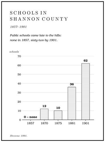
Schools. Before 1850 Missouri’s schools were mostly Subscription school. A school built and paid for by the families who used it, the usual kind in Missouri before 1850 (Chapter 5). Glossary →, built and paid for by the families who used them, and public schools came late to the hills. In 1857 the state counted no public schools in Shannon County, and in 1870 there were twelve. In 1875 the county superintendent, W. N. Deatherage, reported ten schools in the whole county, one frame building at Eminence and nine of logs. Children wrote with ink made from pokeberries and pens cut from goose quills, and school books had to be bought in Thomasville or Salem, forty and fifty miles from Eminence. By 1881 the county had thirty-six public schools, and by 1901 sixty-two, though in 1885 a Shannon County term lasted only twenty-five daysStevens 1991, 110–12.. Eminence organized its public school in 1876, and the school moved from building to building until 1910, when a $10,000 schoolhouse went up on the hill, paid for mostly by the Missouri Lumber and Mining Company so that it could take the children of the mill town at West EminenceLewis 1980, PDF p. 68. as well (Chapter 7).
A schoolhouse often went through several names. In Barn Hollow on the upper river the old school was built of hewed pine logs and named for Samuel K. GillPottenger 1945, Howell file pp. 22, 40., a Union veteran from Illinois who settled there about 1872. In 1890 it was moved to two acres given by Isaac Winningham, and it became Winningham School, also called Dryden School after a nearby farmer. In 1892 or 1893 “the larger girls, wishing the school to have a non-personal name,” renamed it Columbia. Other school names of the river country record their founders and their settings. Little Shawnee SchoolO’Brien 1939, 76., District 37, stood near the Jacks Fork. Harlow SchoolO’Brien 1939, 57., District 1, near Mountain View, honored Reuben Harlow. Possum Trot School in Carroll Township of Texas County carried a name common for schools in remote districtsO’Brien 1939, 108 (“A common name for schools in remote districts”). (Chapter 18).
Attendance was uneven. A woman from the Little Shawnee neighborhood remembered traveling two or three miles to school, staying home in bad weather and being kept out to help harvest the corn, so that by late fall she got “to go a little at a timeStevens 1991, 113. and none of us learned too much.” Teachers were poorly paid; about 1913, in the poorest districts of several Ozark counties, Texas County among them, some earned twenty-five or even twenty dollarsSauer 1920, 208. a month. Most of the one-room schools along the rivers appear to have closed in the early 1950s, when the number of pupils had dwindled, and by 1969 the few children left rode buses to Eminence, Salem or Van BurenBrown 1969, 64–65.. A few of the schoolhouses still stand. One of them, the Storys Creek SchoolStevens 1991, 116, 121–22., was moved to Alley, where it stands near the mill.
Post offices and the names on the map
For a scattered neighborhood a post office was the sure link with the outside world. It was usually a corner of a store or a farmhouse, kept by whoever would take the job, and it came and went with its keepers. To open one, the would-be postmaster wrote to the Post Office Department proposing a name, and sent a form placing the spot by its distance from the nearest offices and streams. A name already in use in the state was turned back. Once approved in Washington, the name became the name of the place on later maps. The Jacks Fork offices trace the settling of the river (Table 5.2). Among the earliest was one that took the river’s own name on the headwaters, in December 1849 by one record and in 1860 by another. The trade towns and the lower river followed in the 1870s and 1880s, and a burst of small offices came with the timber boom about 1910.
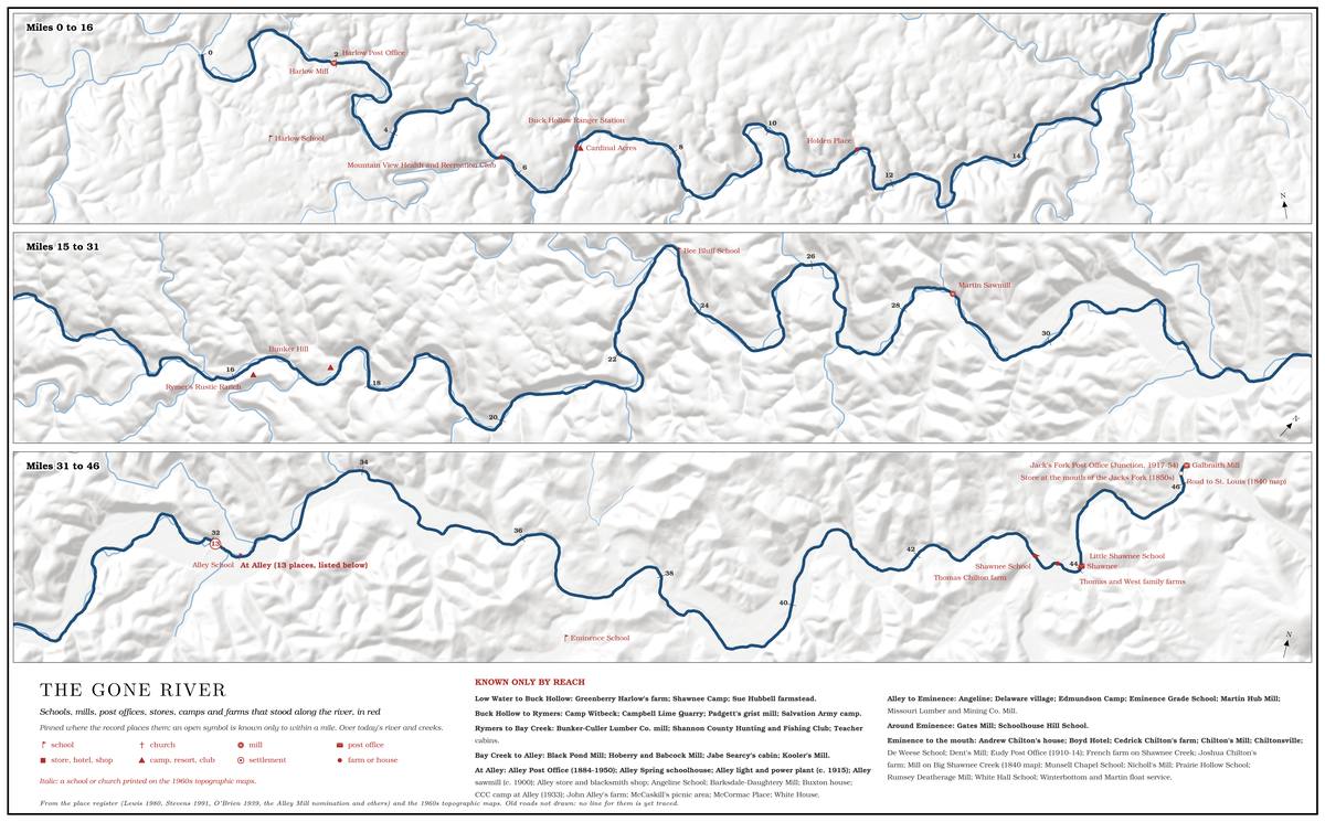
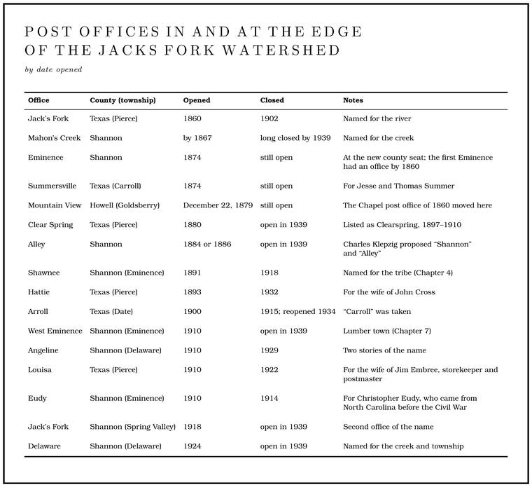
The names carry their own stories. When the office at Arroll opened, the name Carroll was proposed, but the Post Office Department found it already in use, so the applicants “clipped off the C.” AngelineO’Brien 1939, 3. was named either by a settler for a woman in his family or, by another account, by E. B. Grandin of the Missouri Lumber and Mining Company for Mrs. Angeline Grandin. Alley was probably named for John Alley, a fifty-one-year-old farmer who lived three miles east of the spring, and the reasons given for choosing his name all seem to be apocryphalPerry [1978], sec. 8 (the name was “presumed” to be his, and the reasons given “appear to be apocryphal”).. Delaware Creek came firstO’Brien 1939, 36., then the township and last the post office.
Three towns
The households of the hollows needed a few places where they could sell a hog, buy coffee and cloth, pay taxes and get the mail. In the nineteenth century three towns served the Jacks Fork, each on a different stretch of the river.
Eminence. After the war the people of Shannon County gave up the burned county seat on the Current and in 1868 moved the governmentStevens 1991, 63; O’Brien 1939, 43, gives 1870 for the town’s founding. to the wide valley of the lower Jacks Fork, keeping the old name. By one account the county court, Judges Alfred Deatherage, Thomas J. Chilton and William Mahan, met at Mahan’s house in February 1868 and decided to move the seat to what had become the middle of the county. William S. Chilton, sent to find a site, had trouble finding land with a clear title until his brother Thomas J. Chilton gave it. According to one old resident, the giver, Thomas Joshua Chilton, owned a large plantation, and he set aside fifty acresO’Brien 1939, 43. for public streets and alleys running up the hill north of town. The court sold $6,000 of county bonds, at 82 cents on the dollar, and let the contract to William Orchard and T. B. Dunvas of Thomasville for a two-story frame courthouse thirty feet square, finished in 1869. It burned on New Year’s Eve of 1871Lewis 1980, PDF p. 64, the only source., and another two-story frame courthouse replaced it. In 1896 the county clerk’s separate office was filled with Pine knot. The base of a pine limb where it grows into the trunk, so full of resin that it outlasts the rest of a dead tree and burns hot and bright. Pine knots lit the gigging boats, burning in a fire box or metal basket called a firejack in the middle of the boat (Chapter 19). Glossary → and burned, and the courthouse beside it was set afire too but did not burn. Its brick successor, finished in 1899, burned on the night of May 23, 1938Lewis 1980, PDF p. 68.. The new town grew unevenlyStevens 1991, 103.. By 1876 it had about 250 people, four general stores, two hotels, two saloons, three churches, two schools, a weekly newspaper, and a forty-mile Stage. The height of the water surface above a gauge’s datum, the reading a gauge records. A stage differs from the depth of the water. At Eminence the datum stands 616.18 feet above sea level (Chapter 14). Glossary → line to the railroad at Salem. Its exports that year were copper ore, “general farm produce”Stevens 1991, 70. and furs. Mail came twice a week in 1876, three times a week by 1883 and daily by 1889Stevens 1991, 104.. The census taker found eighteen people living in the town in the summer of 1870, the families of a sawyer from Ohio, a real-estate man and a Christian preacher from Maryland who had come by way of Indiana and Illinois. By 1880 the census counted 89, among them that preacher, by then the county’s representative, an innkeeper, a druggist, three lawyers, a blacksmith, a wagon maker, a schoolteacher, a newspaper editor and a saloon keeperLewis 1980, PDF pp. 64, 69, from the census of 1870 and 1880 (the families of Daniel Dye, the Longs and James Creager; in 1880 Creager, “Clergyman and Representative”).. The town counted 140 people in 1884, 300 in 1889 and 200 in 1898, and its leaders were advertising silver oreStevens 1991, 103. from the hills. In 1920 it had 325Bridge 1930, 23..
The name gathered stories. Neighbors joked that the first wagon bearing material for the courthouse broke down at the foot of the hill where it was to be built, and that the townspeople, too lazy to mend it, settled in the hollow. The people of the town rejected the story with some heat, as nothing but envy. The grandson of the man who drove that first wagonload, in the muddy winter of 1867, said the wagon did break down but had nothing to do with the name. In his telling, the Breakdown. The falling of slabs from a cave’s ceiling and walls along their joints once a passage drains and the rock bears its full weight. Breakdown made much of Jam Up Cave’s river entrance (Chapter 13). Glossary → decided where the courthouse stood. The same driver hauled lumber for the courthouse with ox teams from a mill on the Eleven Point, and he was paid a dollar apiece to clear fourteen pinesLewis 1980, PDF p. 64 (W. M. Freeman, the driver of O’Brien’s story). off the lot. Another explanation tied the name to the bold hill north of town and the long view from its top. The driver’s daughterO’Brien 1939, 43 (the story “indignantly rejected, by natives of the town, as inspired by mere envy and uncharitableness”; the grandson is John Freeman, the driver W. M. Freeman and his daughter Mrs. Cora Williams; the hill and its view from A. J. Hawkins). was sure the name had moved with the county seat from the Current, where the first courthouse stood on a bluff. Another explanation has the first seat named for Eminence, Kentucky, the home of the man who surveyed the countyLewis 1980, PDF p. 69, the only source.. A story of a different kind belongs to 1881. A few days after the Blue Cut train robbery near Independence that September, the story goes, Jesse James and his gang put up at the Boyd Hotel in Eminence, rested their horses and had one shod, while the sheriff, George ChiltonLewis 1980, PDF p. 68, the only source. The Blue Cut robbery, near Glendale in Jackson County, was on September 7, 1881., kept the townspeople away from them. The town’s newspaper has a naming story of its own. In 1874 Jake Wingo, a lawyer’s son, moved to Eminence to start a paper, and by the story told in town his wagon broke down while he was fording the Current on the way in. His wife waited in the wagon while he mended the gear, and watching the rough water pour over the Shoal. A fast, shallow, rocky stretch between pools; a riffle. Suckers crowd onto the shoals in spring, and the old saying is that “the dogwoods bloom when the suckers are shoaling” (Chapter 18; Chapter 19). Glossary →, she decided the paper should be called the Current WaveLewis 1980, PDF p. 68, the only source (Lewis puts the ford above Round Spring).. Eminence stayed hard to reach. In 1939, wrote a student who collected the county’s place names that yearO’Brien 1939, iv., it “cannot be reached by any common carrier, but transportation can be arranged with a bread truck driver or perhaps the rural mail carrier.”
Summersville. North of the upper river, Summersville grew where Jesse and Thomas Summer had settled, and it had a post office by 1874O’Brien 1939, 130.. A mill went up there about 1884, and by the early 1890s George and James McCaskill had built a roller millPerry [1978], sec. 8. in town, shortly before George bought the run-down mill at Alley.
Mountain View. South of the upper river, Mountain View began as two rival stores. About 1878, possibly somewhat earlierPottenger 1945, Howell file p. 15., John J. and James Campbell opened one half a mile east of the present town. About 1880 John Goldsberry opened another across the road to the west. Bitter competition followed, and the west-side settlement was nicknamed “Possum Trot.” The Chapel post office, opened in 1860, was moved there in 1879Pottenger 1945, Howell file p. 19., and the office took the name Mountain View on December 22 of that year, with John C. Campbell as postmaster. The Current River Railroad laid out the present town in 1888, and Frank Pollock gave the right-of-way. Old-timers explained the name by the small risePottenger 1945, Howell file p. 73. where the old town stood. The railroad, built east from Willow Springs in 1887–89 to reach the pine of the lower Current, cut a trip that had taken one or two weeks by wagon to four hours by trainStevens 1991, 75, 104. (Chapter 7).
Giraffe-stone houses
On the back roads of Texas and Shannon counties stand houses faced with irregular slabs of orange, red, yellow and white sandstone outlined by raised, rounded bands of mortar. They are called Giraffe-stone house. A house faced with irregular slabs of orange, red, yellow and white Roubidoux sandstone outlined by raised bands of mortar, popular since about 1900 (Chapter 5). Glossary →, and they have been popular since about 1900 because they were cheap to build and lasted (Fig. 5.3). The stone is the Roubidoux sandstone that caps the ridges of the higher Ozarks (Chapter 1). It splits into slabs about four inches thick that need no sawing. A retired stonemason has described how it was done. Masons stacked the slabs as a facing around a wooden frame, sometimes laid directly against the posts, and drew the Joint. A crack along which rock has split without moving. In the riverways the main sets run north-south and east-northeast (Chapter 1). Glossary → into a raised “ribbon” of mortar with a special tool that scraped away the excess. The early mortar was homemade, from Limestone. Calcium carbonate rock formed from lime mud and shells on a sea floor. Most of the limestone laid down here later became dolomite (Chapter 1). Glossary → baked until it crumbled and then slaked with water and mixed with sand. Baking drives the carbon dioxide out of limestone and leaves quicklime, which seizes water so hard that the pile bubbles and turns hot, and once the lime has cooled and been mixed with sand it slowly takes carbon dioxide back from the air and sets hard. Masons named the rock for the places they quarried it. Both the stone and the houses are plentiful in Dent, Crawford, Texas and ShannonSchaper n.d., with the account of the stonemason Ed Krshul (the slaked lime “would bubble, it would actually get hot”). The chemistry of lime mortar is general. counties.
What the century left
By 1880 people had been farming the Jacks Fork valleys for half a century or more, and the pattern of the century was about to break (Table 5.3).
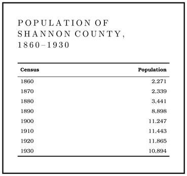
The first decades show the hill pattern. Shannon County grew only about 2.4 percent2,284 in 1860 to 2,339 in 1870 (Stevens 1991, 51, 64, 96; Stevens rounds it to 2.3 percent). between 1860 and 1870. In those years its cleared land fell from 1.5 to 1.3 percent of the county and its cattle herd was cut in halfStevens 1991, 64., losses of the war (Chapter 6). In 1880 improved land still made up only about 2.3 percentStevens 1991, 72. of the county. Then the numbers rose. The population grew forty-seven percentStevens 1991, 69. in the 1870s and more than doubled in the 1880sStevens 1991, 96 (Table 3)., and between 1890 and 1900 the number of farms nearly doubled, from 680 to 1,311Stevens 1991, 96.. Most of the newcomers came for the pine, the railroads and the mills (Chapter 7).
In the 1920s, after the big mills had come and gone, fewer than ten people lived to the square mile in the country around Eminence, a large share of them on farms in the river and creek bottoms. Most descended from the pioneers who had come from Kentucky and Tennessee early in the nineteenth century, and farms that had stayed in one family for several generationsBridge 1930, 23 (“descendants of the pioneers who emigrated to Missouri from Kentucky and Tennessee early in the nineteenth century”). were common. They kept the names on the hollows, springs and schoolhouses, the stock trails and the burned-over woods, and an old understanding of the land that a traveling geographer set down in 1914 and 1915Sauer 1920, ix.: “Whatever land is not farmed is considered semipublic property.” That understanding mattered when the government came to buy the river (Chapter 10).