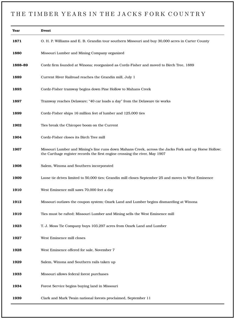
In the 1890s a little steam locomotive built in Lima, Ohio, began running down Pine Hollow toward Mahans Creek, hauling log cars for the Cordz-Fisher Lumber and Mining Company of Birch Tree. People in Shannon County called the engine Euphemia. Its engineer, an Irishman named Hugh Sullivan, was said to pull the throttle out as far as it would go at the start of each run and leave it there until the run was over. When Euphemia crossed Pine Hollow Creek near the Delaware schoolhouse, the teacher gave up on lessons and let the children stand on their desks to watch it pass. One of the children remembered the great ricks of Pine knot. The base of a pine limb where it grows into the trunk, so full of resin that it outlasts the rest of a dead tree and burns hot and bright. Pine knots lit the gigging boats, burning in a fire box or metal basket called a firejack in the middle of the boat (Chapter 19). Glossary →Rader 2017, ch. 8 (the child was Oscar Harper). stacked along the track, where the trainmen stopped to refuel.
Around 1900 a Shannon County newspaper editor, Joshua SholarStevens 1991, 138, after Flanders 1979., saw where it was going. “The celebrated yellow pine of the Ozarks, of which we are so proud, will soon be a thing of the past,” he wrote, and with it would go “the deer and the turkey, the rifle and the hounds.” Within thirty years the big pine was gone from the Jacks Fork country. Lumber companies from outside had bought the hills, laid track up the hollows, built and abandoned whole towns, and left behind Cutover. Land from which the timber has been cut. The lumber companies left much of the Jacks Fork country cutover by about 1920 (Chapter 7). Glossary → land that few people wanted. Game had nearly gone too (see The cutover, below).
The pine woods
The surveyors of the 1820s found mixed pine and hardwood forest over the eastern halfJacobson and Primm 1994, 15–18. The shortleaf pine’s range and bark are general. of the Jacks Fork basin (Chapter 5). The pine was shortleaf, the one pine native to Missouri, a tree of dry ridges and south-facing slopes whose thick, plated bark lets a grown tree ride out a ground fire. It grew big. A man whose grandfather left the upper basin in 1913 said there had been “pines here that were 4 and 5 foot through.” A man born at Alley Spring in 1907 remembered that “between Alley and Summersville, that was all big pine. There wasn’t hardly any oak at all.” A woman whose father cut virgin pine in the Jacks Fork and Eleven Point basins remembered what he told her about those woods: “there was nothing underneath it and you could see so far, see the deer.” Frequent ground fires kept the floor open (Chapter 16).
For most of the nineteenth century the pine was worth little to the people who lived among it, because it could not be got out. The Current, fed by its big springs, ran steady through the year and seldom frozeBrown 1969, 34 n. 6, after Hill 1949., and logs could be floated down it. The Jacks Fork was too shallow and too flood-prone for log drivesJacobson and Primm 1994, 44., and in the back country a farm twenty-five to forty-five milesSauer 1920, 222. from a railroad could hardly ship anything at all. The difference a floatable river made shows in Texas County, where the Jacks Fork rises. On the Big Piney, which runs north to the Gasconade and the Missouri, ten sawmills were at work by 1840, and logs were rafted down to St. LouisGoodspeed 1889, Texas County, “Natural Features.”. Before the Civil War the woods of Shannon County were used for little but Homestead. Public land claimed under the Homestead Act of 1862, which gave 160 acres to a settler who lived on it and farmed it for five years (Chapter 5). Glossary → and for the charcoalLewis 1980, PDF p. 58. that fired the copper furnace on Shawnee Creek (Chapter 5). The farm towns going up on the treeless plains to the west needed lumber badly. What the Jacks Fork pine lacked was a railroad.
The companies
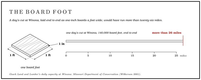
The money came from Pennsylvania, where the old pineries were being cut out. In the late 1860sLewis 1980, PDF pp. 56, 58 (“By 1900, the Grandin Mills were the largest in the world”); Brown 1969, 36–37, gives Grandin “more than two thousand” at the close (see West Eminence, below). a Pittsburgh lumberman, O. H. P. Williams, wrote to the county recorders of several southern Missouri counties asking about land, and the recorder of Ripley County answered. In 1871Brown 1969, 30–36, after Hill 1949. Williams and his son-in-law, E. B. Grandin, came out to look. By one account they took the Iron Mountain railroad from St. Louis to Ironton, went by wagon through Iron and Reynolds counties as far as Eminence, and came back by way of Piedmont, and Williams bought 30,000 acres of timberland in Carter County. The Grandin family’s money is said to have come out of the Pennsylvania oil fields. On September 3, 1880, Williams, J. L. Grandin, H. H. Cummings, J. M. Clapp and a young Pennsylvania mill man, John Barber White, organized the Missouri Lumber and Mining Company, with White as its manager. White bought land off the delinquent tax rolls for twelve and a half to twenty-five cents an acre, often through buyers no one in the neighborhood knewNPS 1960, 51–52 (“dummy” names)., and the company went on buying at a rate of fifteen to twenty thousand acres a yearNPS 1960, 52.. Its first mill, White’s Mill, started in December 1880 east of the Current and could cut six million board feet a year (a Board foot. A piece of wood a foot square and an inch thick, the unit in which lumber and standing timber are both measured (Chapter 7). Glossary → is a piece of wood a foot square and an inch thick, the unit in which lumber and standing timber are both measured), but it stood ten miles from a railroad, and ox teams had to haul its rough lumber to a planing mill at Mill Spring on the Iron Mountain line. When talks with the Iron Mountain railroad for a Branch. A small creek. The sense is American, on record from 1674 (Chapter 18). Glossary → line broke downBrown 1969, 32–33., the company closed it, in 1884.
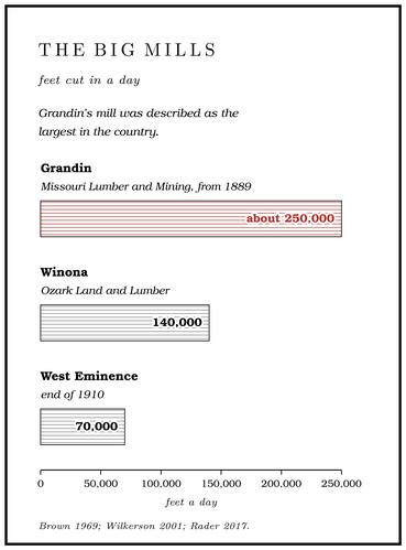
The company waited for a railroad. The Kansas City, Fort Scott and Memphis agreed to build a branch, the Current River Railroad, east from Willow Springs through Mountain View, Birch Tree and WinonaPottenger 1945, Howell file (“Current River Railroad”); Rader 2017, ch. 8., if the company would build a mill big enough to fill the cars, one that could cut 100,000 board feet a day. The branch reached the new mill site in Carter County in late June 1888Stevens 1991, 76 and n. 31 (citing the Jefferson City Tribune, June 20, 1888, among other sources). (one account gives July 1, 1889Brown 1969, 33.), and by one account six million board feet of lumber stood stackedBrown 1969, 33 (Brown ties the stacked lumber to his arrival date, July 1, 1889). and waiting when it came. The new mill went up at a natural pond called Tolliver’s Pond, or Lakewood, and cost by one account a quarter of a million dollars. The mill town took the name of the largest stockholder, Grandin. Its mill was described as the largest in the country, and by 1900, after two more mills were added in 1892, by one account as the largest in the world. Logs waited in a natural pond of three and a half acres, which held half a million board feet and kept them clean and easy to move, and two band saws and a circular saw cut about 250,000 feet of logs a day. A pine log thirty inches through and sixteen feet long scaled about 660 board feet, so a day’s cut came to something like 380 logs of that size. The boards dried in a yard of fifty acres. Kansas, Nebraska and Oklahoma took three-quarters or more of the lumber, and most of the rest went to Illinois, Indiana and Ohio. Estimates of what the company sawed in a year run from fifty to seventy millionBrown 1969, 35 and n. 8 (the log-scale example), after Hill 1949; the count of about 380 logs is reckoned from those figures. board feet, and by one account more than seventy-five million by 1900, when Grandin had swollen to more than three thousand people.
Two other big companies built along the same railroad in Shannon County. The four Cordz brothers, Danish immigrants who had come to the United States in 1878 and worked in the lumber business in Mississippi and then in the North Fork valley of Douglas and Howell counties, founded a firm at Winona in 1888. The next year, with O. W. Fisher as a partner, it became the Cordz-Fisher Lumber and Mining Company and moved ten miles westStevens 1991, 89. to Birch TreeStevens 1991, 89.. It cut about 300 million board feet of lumber before it closed in 1904Stevens 1991, 141–42, after Murphy 1982.. The Ozark Land and Lumber Company built at Winona, a town named by lumbermen from Winona, MinnesotaO’Brien 1939, “Winona.”. It began as the Ozark Lumber Company of Kansas City, whose company town across the tracks from Winona was named Fishertown for its secretary, Joseph Fisher, and in the 1890s it merged with the Hershey Lumber Company of Muscatine, Iowa, which had been milling at SargentStevens 1991, 89. in Texas County. Its mill could cut 140,000 board feet a day, and its stacked lumber covered thirty acresWilkerson 2001, PDF 34.. A day’s cut at Winona, laid end to end as one-inch boards a foot wide, would have run more than twenty-six miles. In 1897 the three companies set up a Joint. A crack along which rock has split without moving. In the riverways the main sets run north-south and east-northeast (Chapter 1). Glossary → selling agency in Kansas City, which marketed 133 million board feet in 1899 and, with two Louisiana firms added, 260 million in 1907Stevens 1991, 89–90..
Birch Tree, Winona and Grandin were the leading lumber camps of the rough hillsSauer 1920, 180. of Shannon, Reynolds and Carter counties. In 1870 all the mills of the southeastern Ozarks together sawed about 3.9 million board feet, and by 1909 each of the big operations sawed more than 60 millionGibson 2000, 24, after Murphy 1982.. In 1912 Shannon County shipped 21,020,000 feetSauer 1920, 181 (shipments of 1912). of lumber, most of it pine. Across the southeastern Ozarks the number of sawmills rose from 20 in 1870 to 187 in 1900Gibson 2000, 24, after Murphy 1982., and Shannon County’s population more than doubled in the 1880s (Chapter 5).
Euphemia and the tramways
The first logging railroad into the Jacks Fork drainage came up Mahans Creek from Birch Tree. In February 1893Rader 2017, ch. 8, citing the Current Wave. the Current Wave reported that Cordz-Fisher would build a tramline from its mill to the pine north of town. The company had begun by buying small parcels of pine north of the tracks, and in the mid-1890s it bought 25,000 acres more to the southStevens 1991, 89.. The track ran north down Pine Hollow to Mahans Creek, at first on rails of white oak instead of steel, and the crews blasted through rock at the sharpest turns. A Tram, tramway. A light logging railroad laid up a hollow, such as Cordz-Fisher’s line down Pine Hollow (Chapter 7). Glossary → was built cheaply, to last only as long as the timber it reachedBrown 1969, 34–35 (of the Missouri Lumber and Mining tramways).. People called the narrow-gauge branch lines Tram, tramway. A light logging railroad laid up a hollow, such as Cordz-Fisher’s line down Pine Hollow (Chapter 7). Glossary → or “sheney lines.” Ozark Land and Lumber’s Grade. The slope at which a river carries its load without cutting down or building up (Chapter 2). Glossary → cost about $600 a mile to build, and the rails, bolts and splices were rented from the main-line railroad at $100 a mile a year. Where a tram had to cross a stream, it sometimes forded it on a “sheney bridge,” a bed of rock laid on the stream floor with the track spiked down on top, like a Low-water bridge, low-water crossing. A road crossing built low across a stream, a ford with a floor, often a concrete slab with culvert pipes beneath it, which water overtops in a rise (Chapter 8; Chapter 18). Glossary →, so that the train ran through the water. Wrecks were common, from rock slides, poor track and stock on the line, and between 1903 and 1907 the company at Grandin paid out $2,306.60 for livestock killed on its tracks. Spurs went up the side hollows, one of them by one account into Larkin Hollow and over the hill along Bee RidgeLewis 1980, PDF p. 56, the only source; Lewis lists the camps as Dry Camp, Nine Row, Store Camp, Oklahoma, Puerto Rico and Cuba, all among Rader’s, and dates the Pine Hollow line about 1894., and when a hollow was cut out the rails were pulled up and laid again in the next one. By 1897 the main line reached the Jim Rader farm near the Delaware schoolhouse, and Euphemia was pulling the loaded cars back up the hollow to Birch Tree. By one account Cordz-Fisher began with a single small Shay, a geared engine built for steep, crooked track, fired with pine knots, and got the larger Euphemia later, and Euphemia probably went in the end to the mill at West Eminence and ran there as Engine Number Nine. The company’s engines and those of Ozark Land and Lumber burned wood, and the Missouri Lumber and Mining engines on the main line at Grandin burned coal. Until 1907 the log cars were built of pine, and after that of oakLewis 1980, PDF pp. 56, 58, the only source (Euphemia “was evidently sold to the mill at West Eminence”). What a Shay is, is general.. Birch Tree boomed. Cordz-Fisher employed more than four hundred men, ran two company stores, a waterworks, an electric plant and a telephone system, and in 1899, running day and night, shipped more than 16 million feet of pine lumber and 125,000 railroad ties.
The company housed its crews in camps along the tramway. Some of the men lived first in tents, and later in shotgun shacks that could be loaded on flatcars and moved to the next tract. The camps were named Log, Dry, Nine Row, Store, Spring, Oklahoma, Pine Hollow and Delaware, and in 1898, when the war with Spain was in the news, Puerto Rico and Cuba. Delaware, the largest, had a boardinghouse, a company store, a company doctor and a baseball team. The local people called the newcomers from Wisconsin and other lumber states “Furriner. The hill word for an outsider, such as the lumbermen who came from Wisconsin and other lumber states (Chapter 7). Glossary →.” Ties ran a close second to pine at Cordz-Fisher. In 1897 a local man reported that the tramway was shipping “40 car loads a day from the big tie works in Delaware Township. A survey square of six miles on a side, holding thirty-six sections; also a division of a county, such as Jack’s Fork Township (Chapter 5). Glossary →.”
Rails to Horse Hollow
Missouri Lumber and Mining cut out the country around Grandin first. Its workforce grew from 1,000 in 1900 to 1,500 in 1905. By 1903 it had cut over 213,017 of the 324,017 acres it had bought since 1888, and its buying had moved north into Shannon County, where the Frisco railroad, which since 1901Stevens 1991, 90. had owned the system the Current River line belonged to, offered it a lower freight rate on lumber shipped from the northwest of the county. In 1907, its most profitable year, the company laid a standard-gauge line north from a point on the Current River Railroad about two miles west of Winona, later called Winona Junction. The track ran down Mahans Creek to its mouth, crossed the Jacks Fork, followed the river Bottom. The flat land along a river or creek, built of its deposits and open to its floods. In the 1920s the bottoms near Eminence averaged about a quarter of a mile wide (Chapter 2; Chapter 5). Glossary → west along the north bank to the mouth of Horse Hollow, and climbed the hollow to a logging camp named AngelineStevens 1991, 90, after Murphy 1982 and Hill 1949., which had its own post officeRader 2017, ch. 8. (Map 7.1). From there more than seventy miles of tram track eventually reached up the hollows and ridges north of the river. By one account the lines went on across the divide to the Current, which they crossed on a trestle near the mouth of Boyds Creek and again at Pulltight Spring, with camps named by number, Camp Five in Harrison Hollow and Camp Six farther on, spurs down Spring Valley to Round Spring and to the company’s Mine No. 15, and another up the valley toward Ink that stopped short for want of a right-of-way. Businessmen in Eminence hoped the line would go on north to meet the railroad at SalemLewis 1980, PDF p. 56 and the map at PDF p. 57, the only source., and it never did. By one account a track also ran on up the river into Alley Hollow in 1907 and was later torn outLewis 1980, PDF pp. 52 (“In 1907 a tram was built up the river and into Alley Hollow”), 56 (“The line up Alley Hollow was torn out and the line went into Horse Hollow”), the only source; see Reach I. (Reach I). On May 24, 1907, a party of Carthage fishermen floating the Jacks Fork from a point about three miles above Eminence wrote in their club register that they had caught sixty bassStevens 1991, 152; Hall 1969, 204, prints what appears to be the same register entry, undated, with sixty-nine bass. and had “Saw first engine cross Jack’s Fork.”
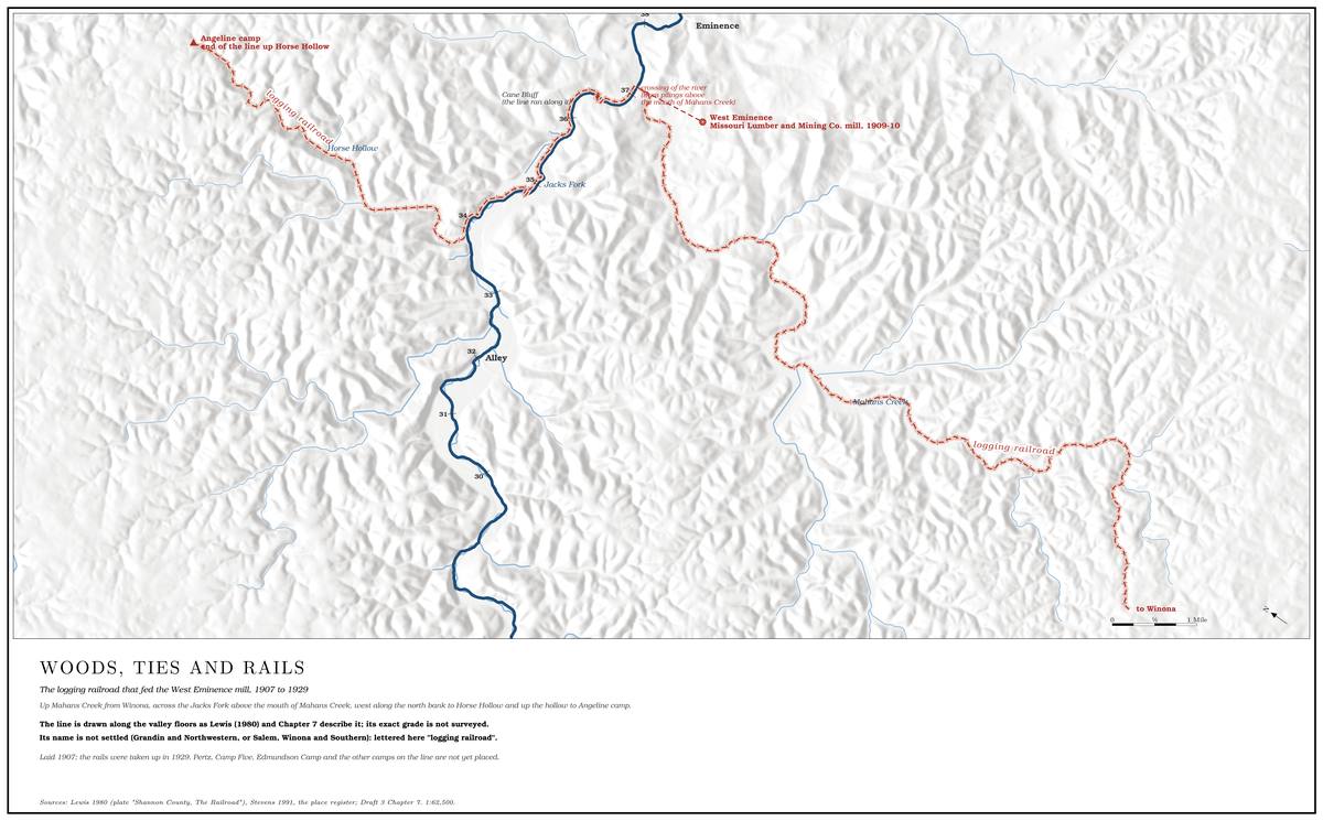
The company ran the line as a separate railroad corporation, the Salem, Winona and Southern, incorporated in 1908ICC 1912.. It was one of the Southern “Tap line. A short railroad that a lumber company built from its mill to a main line and incorporated as a common carrier, so as to share in the freight charges. The Salem, Winona and Southern was one (Chapter 7). Glossary →.” A lumber company that built a short railroad from its mill to a main line could incorporate it as a common carrier, open to any shipper, and the main-line railroad would then hand it a share of the freight charge on every car of lumber that came off it. The share went, in the end, to the lumber company that owned the tap line, and in 1910–12 the Interstate Commerce Commission examined the tap lines, this one among them, to decide whether those shares were rebates by another namegeneral history of the Southern tap lines and of the Interstate Commerce Commission’s tap-line investigation of 1910–12.. The lumber company owned about nineteen miles of track from Winona Junction to Horse Hollow and leased the thirteen miles to West Eminence to the railroad for $12,000 a year. The railroad operated the rest of the line as well, and it reached Winona over about two and a half miles of Frisco track. The logs went to the mill behind the lumber company’s own enginesICC 1912., and the tap line hauled none of them. The tap line owned no track, right-of-way or equipment of its own. It leased from the lumber company two locomotives, two coaches, a caboose, two boxcars and fifty flatcars, and its capital stock was $150,000. In the fiscal year 1910 it carried 53,101 tons of forest products for the lumber company and 3,006 tons for everyone else, and the record before the commission admitted that it had been incorporated to secure a share of the rates from the Frisco. On lumber delivered at Winona the Frisco allowed it from one to four cents a hundred pounds. Its passengers paid $5,302.49 that year, and it took in $822.86 for carrying the mail. In 1912 the commission found that lines like it were really part of the mills they served and ordered the allowances to them stopped or cut down, and for this one it held that anything beyond a small share of the rateICC 1912 (23 I.C.C. 277 and 549), read in a transcribed abstract of the two reports; page numbers within them not seen. The abstract gives the division the commission would allow as “1-1 cents per 100 pounds,” an evident misprint, so the text says only “a small share.” would be unlawful. In May 1914 the Supreme Court held that the tap lines were common carriers and could share in the rates, though the commission could still cut down any share that amounted to a rebate to the mill’s ownersTap Line Cases 1914 (decided May 25, 1914; opinion by Justice Day).. By one account the Salem, Winona and Southern was first chartered as the Grandin and NorthwesternStevens 1991, 90, after Hill 1949, 210, the only source found. Railroad Company, though no charter under that name has been found (The Open Ledger).
The Salem, Winona and Southern carried more than logs. From 1909 it had a loading Chute. A narrow, fast slot of water through a shoal or past an obstacle. A smooth V of water pointing downstream marks the deepest path through it (Chapter 20). Glossary →, stock pens and a flag station on the Jim Rader farm at Delaware, and Mahans Creek farmers could ship livestock from the creek straight to Springfield, St. Louis and Kansas City. Until the Current River Railroad came through, in 1888see the railroad’s date above (Stevens 1991, 76; Brown 1969, 33, gives July 1, 1889). (1889 by another account), they had driven stock more than fifty miles over the hills to the railroad at Salem, and after that to Birch Tree or Winona. A passenger train ran once a day each way between Horse Hollow and Winona, and another between West Eminence and Winona, and riders could flag it down anywhere along the line. In 1912 the Current Wave called it the “most accommodating railroad in the state,” running special excursions to fairs, ball games and speakings. The fares were high for a country where a day’s wage was a dollar and a half, though: in 1909 a round trip to Winona cost $1.20. Locals said the initials stood for “Start, Wobble and Stop.” Sparks from the engines set fire to the grass and brush along the right-of-way and burned rail fences, the trains killed livestock and hounds, and the railroad laid part of its track on the public road up Mahans Creek, so the farmers had to build a new road. The work was dangerous too. Euphemia jumped the track three times in 1899, and a collision with log cars in 1904Rader 2017, ch. 8, citing the Current Wave. killed one man and cost another a leg.
West Eminence
At first the logs rode the rails all the way back to Grandin, more than sixty miles. That was costly. A brief recession at the end of 1907 cut lumber prices and orders, and by then the Grandin mills were running only four days a weekNPS 1960, 52.. The company moved the mill to the timber. The whistle at Grandin blew for the last time on the Saturday night of September 25, 1909, and the mill ran until half past nine that night sawing sunken logsLewis 1980, PDF p. 58. raised from the bottom of the millpond. In the fall of 1909 the mill was taken apart and rebuilt a mile west of Eminence, a short way up Mahans Creek, and the company built a new town around it, West Eminence. Many of Grandin’s buildingsStevens 1991, 90. went with it, and the company pulled the windows and doorsNPS 1960, 52. out of the houses it left behind. At Grandin more than a thousand men lost their jobs, and a town of more than two thousand shrank within months to a fraction of its sizeNPS 1960, 52.. The high school closed, the grade school shrank to one room, and no congregation was left large enough to keep a regular pastorNPS 1960, 52 (the Grandin editor, as quoted there).. Before the newspaper moved away to DoniphanBrown 1969, 36–37., its editor wrote that “the sawmill has proved to be the advance guard of civilization and progress; with the passing of the sawmills, people have turned to the soil.”
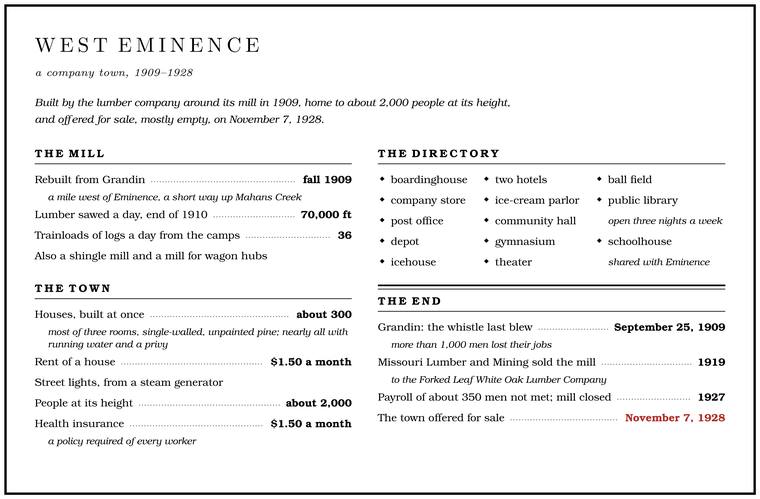
The mill, built in 1909 and 1910, had a sawmill, a planer, dry kilns, drying sheds, a depot, a loading dock and a millpond. Logs were taken out of the pond, scaled for their board feet and sawed, and the boards were graded and sent either to the dry kilns or to the drying sheds. Once most of the moisture was out, they went through the planer and were ready to shipLewis 1980, PDF p. 58.. By the end of 1910 the West Eminence mill was sawing 70,000 feet of lumber a day, and keeping it running took thirty-six trainloads of logs a day from the camps in the woods. The company added a shingle mill and a mill for wagon hubs. Workers and their families lived in tents until the houses were ready. The company built about three hundred houses at once, four hundred by another count, most of them three-room, single-walled houses of unpainted pine that rented for $1.50 a month, nearly all with running water and a privy. A steam generator lit the streets. The company built a boardinghouse for single men, a large store whose clerks walked the town each morning taking grocery orders and delivered them in the afternoon, a post office, opened on January 20, 1910, a depot, an icehouse, two hotels, the Ladies Boarding House and the BeaneryLewis 1980, PDF p. 61., an ice-cream parlor, a community hall, a gymnasium, a theater for vaudeville and movies, a ball field, a public library open three nights a week and a schoolhouse that Eminence shared. At its height the town held about 2,000 peopleO’Brien 1939, “West Eminence.”. Every worker had to carry a health insurance policy at $1.50 a month. The company kept local ministers on retainers, apparently expecting them to preach sobriety, self-restraint and resistance to union organizers. The mill whistleRader 2017, ch. 8 (the retainers from company papers; that the company expected sermons on sobriety, self-restraint and resistance to unions is Rader’s reading). blew at 5:30 every morning but Sunday to wake the town, again at 7:00 to start the shift, and at 6:00 in the evening to end it, and families up Mahans Creek would likely have heard it on their farms. When word came of the armistice in November 1918, the train whistle and all the mill whistles began to blow at four in the afternoon, and at nine that night some of the boys set off a bunch of dynamite on Schoolhouse Hill. A rumor went around that one man in town was a German spy, the story goes, and he took the chance to leave the country for goodLewis 1980, PDF p. 61, the only source..
Workers were usually paid in cash once a monthGibson 2000, 25, after Murphy 1982., but wages came partly in Scrip. Company coupons paid as part of wages, good for rent and goods at the company’s stores. Missouri outlawed the coupon system in 1912 (Chapter 7). Glossary →, coupons good for rent, groceries and other goods from the company. The scrip soon passed from hand to hand in Shannon County as moneyRader 2017, ch. 8.. Goods bought with coupons cost inflated prices, abuses were common enough that Missouri outlawed the coupon system in 1912, and there was no unionGibson 2000, 25, after Murphy 1982.. The one attempt in the region to organize mill workers, at the Cordz-Fisher mill in Birch Tree in 1903Rader 2017, ch. 8, n. 10., failed.
Taking the pine
The big companies cut the pine and left most else standing. Crews took pines twelve inches or more across at the stump, and in the first years around Grandin they cut many that measured forty-five inchesBrown 1969, 34.. They sawed them into logs of twelve or sixteen feet and skidded them with mules, or loaded them on wagons drawn by oxen, horses or mules, to the nearest tram line, where they were loaded by handRader 2017, ch. 8 (twelve-foot logs); Brown 1969, 34 (12- or 16-foot lengths). onto the log cars. Steep slopes were often passed overJacobson and Primm 1994, 1–2, 38 (also pp. 41–42).. A man born at Alley Spring in 1907 said the cutters went down to trees about twelve inches through. The man whose grandfather left the upper basin in 1913 said that by then “they had just about finished cutting the native timber off… They didn’t leave anything,” and that the oak that came up afterward was “half post oak and half white oak.” Driving loaded log wagons down the steep hollows frightened even the teamsters. “We have had a good many drivers quit… afraid to bring their loads off the hills,” a company man wrote in 1907. Within about a decade Missouri Lumber and Mining cut more than 150,000 acresRader 2017, ch. 8. of shortleaf pine in northern Shannon County.
People who owned pine came into money all at once. Land that had been worth almost nothing brought company agents to the door offering hundreds of dollars for the timber rights. Jim Rader of Delaware received more than $1,500Rader 2017, ch. 8. for his. Not everyone got a fair price. In 1906, when a group of landowners on Mahans Creek held out for more, Missouri Lumber and Mining sent two men to spend “a couple of days” visiting them, “to a good effect,” a company official reported. “Some of them reduced their prices by as much as $100.”
After the pine came the hardwoods. Oak went for railroad ties, flooring, wagon hubs and barrel staves, hickory for tool handles, and walnutBrown 1969, 34; Sauer 1920, 182. wherever it could be found. Small portable mills cut pine at great distances from the railroadsSauer 1920, 181. and took the smaller pineStevens 1991, 91. the big crews had left. Along the Jacks Fork itself small sawmills worked the side creeks into the 1920s, two of them on Bay Creek and one at the mouth of Fish Trap Hollow, and from 1912 to 1916 a steam sawmill ran at AlleyLewis 1980, PDF pp. 40, 44, 53; see Reaches F–I. (Part Five, Reaches F–I). J. S. Bunker, who began in small lumber works at Mountain View and Summersville, went on to found a large pine company of his ownStevens 1991, 142 (“Another large corporate pine lumber operation”). The word means something else at Grandma Rocks (Reach G)., Bunker-Culler, which began cutting on the creeks of the upper CurrentStevens 1991, 142. in 1909. The many small operators probably did as much as the big corporationsStevens 1991, 91 (Stevens’s judgment). to exhaust the timber of the Current valley and the uplands around it. By the 1930s families on poor hill farms were “Timber scrapping. Cutting and selling immature trees for whatever they would bring, as families on poor hill farms did in the 1930s (Chapter 7). Glossary →,” cutting and selling immature trees for whatever they would bring. The hills had a word in those years, “Grandmaing. A hill word of the 1930s for stealing timber from public land or from absent owners and saying it came from “grandma’s” land (Chapter 7). Glossary →,” for stealing timber from public land or from land owned by nonresidents and saying it had come from “grandma’s” land.
Ties
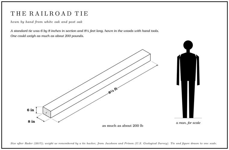
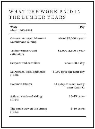
By the 1910s ties were the most important hardwood product of the Ozarks. The railroads spreading across the prairies to the north and west needed them by the million, and an untreated oak tie lasted only some years in the roadbed before it rotted and had to be replaced. White oak and post oak from the Ozark hills supplied them, and in 1912 Ripley County, on the lower Current, shipped 808,000Sauer 1920, 183; Stevens 1991, 149.. A tie was hewn in the woods with hand tools: a crosscut saw to cut the log to length, wooden mauls to split it, and a broadaxe to hew the faces flat. A standard tie measured six by eight inches and eight and a half feet long, and a man who hacked ties on a creek west of the Jacks Fork remembered ties that weighed as much as two hundred poundsJacobson and Primm 1994, 52–53.. Estimates of the pace vary: a pair of skilled hackers could make about ten ties a day by one account and thirtyStevens 1991, 143, after Murphy 1982. by another. In 1914 a tie brought twenty-five to forty-five cents at a railroad siding, and the tree it came from was worth “rarely more than ten cents and in many cases only five” on the stump. The difference paid for the hewing and the hauling, and for the commission of the contractorSauer 1920, 182–83 (“Ties are the most important hardwood product of the Ozarks”). who bought the ties. On the upper Current the Smalley Tie and Timber Company of Van Buren, which Missouri Lumber and Mining backed, paid the lumber company five cents for each white oak tie and three centsStevens 1991, 143, after Hill 1949, 191–92. How long an untreated tie lasted is general. for ties of other wood. The hacking was also dangerous. Alford Eddings cut off three of his toes hacking ties in the fall of 1917.
Farmers hewed ties in winter, sawmills cut them from logs too small for lumber, and professional Tie hacker. A man who hewed ties in the woods for a living, moving on when the tie timber ran out. Farmers hewed ties too, and tie hacking outlasted the pine by decades (Chapter 7). Glossary → lived in shacks in the woods and moved on when the tie timber ran out, seldom staying in one place more than a few years. The farmers looked down on them, and they had a name for being a lawlessSauer 1920, 182–83. lot. Tie works grew up along the railroads. Besides the big tie works at Delaware in the 1890s, BuckhartRader 2017, ch. 8., a stop on the Salem, Winona and Southern up Mahans Creek, had another in the 1910s. At Winona, gangs of Black laborers were brought in for the heavy and dangerous work of loading ties onto railroad cars. No Black familiesRader 2017, ch. 11. lived permanently in Shannon County at the time, and it was claimed of Missouri Lumber and Mining at Grandin that it never employed Black, Italian or Hungarian workers, though by 1907 Black men were hired for temporary jobs such as loading ties on the tram roadsNPS 1960, 52..
Tie hacking outlasted the pine by decades. Of the older people of Shannon and Carter counties who told their families’ histories in the late 1990s, nearly all had worked in the timberGibson 2000, 49 (the Park Service’s interviews). or had a relative who did, and most of those had hacked ties. Upper-basin people remembered brothers hewing tiesJacobson and Primm 1994, 41–44. in the 1930s and ties cut in the 1930s and 1940s “immediately upstream from the North and South Prongs.” A man whose family came to the upper basin in 1932Jacobson and Primm 1994, 41–42 (and Table 6, 40). remembered two kinds of trees in the woods of his youth, “great big, ‘wolf’ trees” and younger timber, and that what people cut with their crosscut sawRader 2017, ch. 13 (Eddings was Rader’s grandfather).s was the younger stuff “that got big enough to make a tie.” A tie cutter of the 1930s worked trees spotted with red paint for a buyer in Winona, and in the 1940s one family cut “a load of ties maybe twice a week” and hauled them to the railroad at Sargeant. A man who cut ties above the Forks, the. The North and South Prongs and their junction, where the Jacks Fork begins; also called the Prongs (Chapter 18). Glossary →same, 42. summed up the rule of those years: “If it wouldn’t make a tie, they wouldn’t cut it.” After Prohibition ended in 1933, white oak found a second market as staves for the barrels in which bourbonRader 2017, ch. 13. whiskey was aged.
Floating the ties
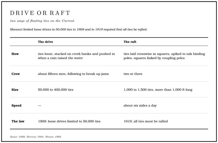
Hauling ties by wagon tore up the roads. Floating them made tie cutting pay at long distances from the railroad, and on the Current River floating was the usual way. In a drive, the ties went loose. Hackers stacked them on the banks of small creeks and, when a rain raised the water, pushed them in as fast as they could, so that they would reach a bigger stream before the creek fell againSauer 1920, 183.. A crew of about fifteen men followed them down the river, breaking up jams. Drives on the Current often started near Montauk and picked up ties all the way down, and they held from 50,000 to 400,000 ties. A Flash flood. A sudden, fast rise of water after heavy rain, fed by quick runoff from steep slopes (Chapter 14). Glossary → made a loose drive dangerous to the crews and to everything along the banks, so the Smalley company usually ran its drives in the fall, but they could get out of hand even without a flood. In the fall of 1902 the weight of the ties piled against the catch boom at Chicopee, just below Van BurenStevens 1991, 76 (“the point just south of Van Buren where the Current River Railroad crossed the Current River”); Klinger and Kandare 1987, 37–39 (“Chickopee below Van Buren”); Brown 1969, 34, has “Chicopee opposite Van Buren.”, broke it, and 5,000 tiesStevens 1991, 143. went downriver. The crews tried to stop them at a tram bridge near Grandin, and many got past it and went on to DoniphanStevens 1991, 143, 149.. In a raft, the ties were laid crosswise in squares of thirty to fiftyBrown 1969, 36. and spiked to oak binding poles with forty-penny nails, and the squares were linked with coupling poles loose enough to bend around the river’s turns. A crew of two or three could take a raft of a thousand or fifteen hundred ties, more than a thousand feet long, down the river at about six miles a day. The man at the front steered. When the front square dropped into a rapid, the man at the back snubbedBrown 1969, 36–37. hard with his pole, and both poled across the Pool. A deep, slow stretch of river between riffles (Chapter 16). Glossary → below (Fig. 7.1). A loaded raft was heavy enough to make its own way through much of what it met, but one that struck an obstruction could pile up, and the whole batch of tiesBrown 1969, 37. could be lost. Missouri limited loose drives to 50,000 ties in 1909 and in 1919Jacobson and Primm 1994, 28; Stevens 1991, 149. required that all ties be rafted.
The Smalley company dominated the trade on the upper Current, sending its crews upriver in a small paddle boat to bring the ties down. Around 1920 it shipped about 200,000 ties a yearStevens 1991, 143–45.. At the loading chutes at Van Buren and Chicopee, Black crews from SpringfieldGibson 2000, 50. loaded the ties onto an endless chainStevens 1991, 146 (fig. 32). that pulled them up out of the river and onto the railroad cars, and other men worked the river for the “dead heads,” ties that had soaked up water and sunk. A man who lived on the Current near the mouth of the Jacks Fork in the 1920s remembered that “every 2 or 3 days there would be a tie raft come around.”
Whether ties floated on the Jacks Fork depends on which stretch of the river is meant. People who grew up in the upper basin remembered little or no timber going down the Jacks Fork, because the river was too shallow and too flood-prone, and timber from their country went out by wagon road and tramwayJacobson and Primm 1994, 44 (the Geological Survey’s interviews).. The lower river was different. Timber families remembered men riding ties down the river to be landed at West Eminence or at ChicopeeGibson 2000, 49–50 (the Park Service’s interviews of the late 1990s)., and companies and individuals along both the Current and the Jacks ForkBrown 1969, 36. floated ties to Chicopee. Two places on the river are remembered for it. In the tie-cutting days there was a tie yard at the mouth of Big Shawnee CreekLewis 1980, PDF p. 79; see Reach J., near the river’s mouth (Reach J). Upstream, at the Flat Hole above Bay Creek, between Bee Hollow and Turkey Roost Hollow, ties are said to have gone into the river down a chute from a tie yard above the pool, and its slow, flat waterLewis 1980, PDF p. 40 (“The Flat Hole is between Bee Hollow and Turkey Roost Hollow … There was a tie yard above the hole. Here they dropped ties into the river down a chute. It took along time to get through the slow, flat water hole”), the only source; see Reach F. Lewis’s other Flat Hole, below Cane Bluff, is “a flat, small, rock bottomed hole” with no tie story (Lewis 1980, PDF p. 54; see Reach I). took a long time to get through (Reach F).
Wages and the boom on the creeks
The timber boom put cash into hollows that had run largely on barter (Table 7.1). Managers and skilled men were usually brought in from outside, and local men took most of the common labor. A millworker at West Eminence earned $1.50 for a ten-hour dayRader 2017, ch. 8., and foremen, sawyers and other skilled men earned a little more.
The farm families around the camps and mill towns found new customers. Jim Rader sold pork to the company store at West Eminence, and his brother Sam sold wagonloads of watermelons in Eminence and West Eminence. Some farm women sold eggs, milk and vegetables from camp to camp. Mary Randolph, who lived at the mouth of Pine Hollow, sold produce to timber families and was said to have buried her savings, $800, in a fruit jar in the corner of her garden, until in 1900 she used it to help build the finest house in the neighborhood. Delaware Township’s population grew by almost 70 percent in the 1890s. By 1900 nearly every Forty. Forty acres, a quarter of a quarter section. A hill farm was often one or two forties (Chapter 5). Glossary → along the creek bottom and up the side hollows had a house, a corn patch and perhaps a garden, and between 1890 and 1910 the number of farms in the township nearly doubled. With cheap pine lumber at hand, families gave up log houses for “sawmill houses”Rader 2017, ch. 8. of vertical pine boards nailed to a sill and a top plate, with battens over the cracks and newspaper pasted on the inside walls against the cold.
The end of the mills
The boom closed down in Stage. The height of the water surface above a gauge’s datum, the reading a gauge records. A stage differs from the depth of the water. At Eminence the datum stands 616.18 feet above sea level (Chapter 14). Glossary →, and the men who ran it moved on to the pine of the Deep South and the Pacific Northwest, to companies in Louisiana and to a Grandin Coast Lumber Company in Washington StateStevens 1991, 142, after Hill 1949 and Murphy 1982.. Cordz-Fisher shut its Birch Tree mill in 1904Rader 2017, ch. 13.. Ozark Land and Lumber began taking apart its Winona mill in 1912, and in 1923 the T. J. Moss Tie Company bought 103,297 acresStevens 1991, 141–42, after Murphy 1982. from it. By 1919, when Missouri Lumber and Mining sold the West Eminence mill to the Forked Leaf White Oak Lumber Company and left the Ozarks, it had cut nearly all its pine north of the Jacks Fork, and only a few acres of pine stood anywhere in Shannon County. In the early 1920s the new owners extended the railroad up the river into Troublesome Hollow, and by one account the mill passed in the end to the Ferguson Lumber CompanyLewis 1980, PDF pp. 56, 58, the only source.. In the poor lumber market of 1924, the Current Wave reported, not a mill in the county was sawing logs. In 1927 the Forked Leaf company could not meet its payroll of about 350 men at West Eminence, and the mill closedLynott 1981, 59–60; Bridge 1930, 25 (the last of the district’s mills to close, “the mill at West Eminence in 1927”).. Soon afterward fire destroyed the company store. The town was offered for sale on November 7, 1928O’Brien 1939, “West Eminence.”, by then mostly empty except for the hulk of the mill, and the county bought part of the company’s land for a new poor farm. By one account the county farm had moved to West Eminence in 1927, the year the mill closed, and it ran until 1948, when the coming of the old-age pensionLewis 1980, PDF p. 61 (“The County Farm was moved to West Eminence in 1927”; “With the advent of the ‘old-age pension’ the farm closed in 1948”), the only source; PDF p. 75 has it moved “when the mill shut down.” Rader 2017, ch. 13, puts the county’s purchase after the town was offered for sale. closed it. In 1929Rader 2017, ch. 13. the Salem, Winona and Southern took up its railsBridge 1930, 27 (the line “discontinued when the sawmill at West Eminence closed in 1927 and the rails have been torn up”). along Mahans Creek. The places along the line, from the crossing at the mouth of Mahans Creek to Horse Hollow, are described in Reach I.
Cutting never stopped altogether. Local sawmills went on working, and T. J. Moss Tie became the largest owner of cutover landRader 2017, ch. 13. in Shannon County, holding oak for ties.
The cutover
The companies kept the land only as long as it held timber. Holding cutover land cost an estimated ten cents an acreNPS 1960, 52–53. a year in taxes, and the companies asked the legislature, without success, to excuse them from taxes on land they were no longer working. Missouri Lumber and Mining ran experimental and demonstration farms, trying cattle and fruit, and sought a state experiment station for Grandin, which went to Mountain View instead. It offered its cut land as farms, sometimes on the installment planNPS 1960, 53., advertising 65,000 acres in 1898 as the “finest fruitland in the state” and urging a trade journal to promote its holdings as the “Land of the big red apple.” Peaches and tomatoesRader 2017, ch. 13. did well enough on the flatter uplands around Birch Tree and in Howell County, but the thin, cherty soils of the hollows could not support farming of that kind, and much of the cutover was sold in pieces as small as forty acres, abandoned for taxes, or grazed as Open range. The old rule that a farmer fenced his crops in and let his animals run on all unfenced land; also called free range. Shannon County kept it the longest in Missouri, until a state law of 1969 (Chapter 5). Glossary → by whoever ran stock on it.
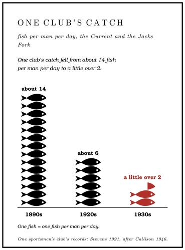
The range and the spring burning that went with it were old customs (Chapter 5), and the cutover gave both more room. Fire killed the pine seedlings on cutover land and burned away the litter, and the pine could not come back. A geologist mapping the country around Eminence in the 1920sBridge 1930, 25 (Josiah Bridge), as quoted in Jacobson and Primm 1994, 31. called the lumbering there “most wasteful” and wrote that the rougher land had “been burned over repeatedly and the present second growth is an almost worthless variety of scrub oak.” Blackjack oak, broom sedge and cheat grass spread where pine and bluestem had grown, and walnuts, hickory nuts, hazelnuts, wild grapes, blackberries and wild honeyRader 2017, ch. 13. grew scarcer. By 1914 hunters rarely met a deer, in 1920 the state closed the deer seasonRader 2017, ch. 13. altogether, and by the end of the decade game animals and fur bearersBrown 1969, 39. had almost disappeared. One sportsmen’s club that fished the Current and the Jacks Fork recorded about fourteen fish per man per day in the 1890s, about six in the 1920s and a little over twoStevens 1991, 155 (table 4), after Callison 1946. in the 1930s (Chapter 9). The gravel that followed the cutting and burning into the rivers is the subject of Chapter 15. By one judgment the lumber companies left a more bitter memory along the Current and the Jacks Fork than the Civil War didBrown 1969, 37 (the legacy “was far more bitter than that left by the Civil War”; Brown’s judgment)., and in 1977 a Shannon County man said the sameRader 2017, ch. 13 (G. L. Davis)..
The government buys the hills
By the early 1930s much of the cutover was in desperate shape, and so were many of the people on it. Through the 1930s about two-thirds of the people of the region had no adequate local source of income. In the Clark National Forest area between 25 and 30 percent of all families were on relief in 1938, and in four communities of the region 60 to 90 percentNPS 1960, 54. of the families lived on work relief, direct relief or pensions. A citizens’ association formed in 1929 to push for national forests in Missouri, and in 1933USDA Forest Service, “Stop 9 Panorama.” the legislature passed the act that let the federal government buy land in the state. The state limited the government’s purchases in any one county, at first 25,000 acres, and in 1934 the limit was raised to 100,000. Not everyone in Shannon County wanted the limits lifted. State Senator David Bales of Shannon County opposed it because public land would shrink the tax base, and others feared that a federal forest would end the open range and the spring burning. State Senator L. N. Searcy of Eminence led the drive that removed the limits altogetherStevens 1991, 197, after Murphy 1982..
The Forest Service began buying land in 1934, and by the end of 1935 about a fifthStevens 1991, 197, after Murphy 1982. of Shannon County lay inside its purchase boundaries. On September 11, 1939, President Franklin Roosevelt proclaimed the Clark and Mark Twain national forests from the purchase units in Missouri, and the two were merged as the Mark Twain National Forest in 1976USDA Forest Service, “Archaeology and Cultural Resources.”. Many owners sold because the cutover acreage had little if any valueNPS 1960, 54. to them. The Forest Service and the Civilian Conservation Corps, whose camps in the region included one at WinonaStevens 1991, 197., built roads, lookout towers and telephone lines, fought fires and planted treesStevens 1991, 197., and about 5,000 menGibson 2000, 93–94, after Murphy 1982. in the region found work with the Forest Service. A forest job was steady and paid better than most, and it carried some standingNPS 1960, 54, after Kauffman 1939. in the hills. The fears about burning came true (Chapter 5).
The national forest touched little of the Jacks Fork watershed itself, which now holds only about 4,000 acres of it. The Missouri Department of Conservation bought far more. It holds about 40,000 acres in the watershed, the largest share of it in AngelineWilkerson 2001, PDF 38–39. Conservation Area, which carries the name of the old logging camp. The shortleaf pine has crept back onto the ridges since the 1930s (Chapter 16), and a second round of timber cutting from the mid-1950s into the early 1970sJacobson and Primm 1994, 27. worked the second growth. Shannon County held a little under 11,000 people in 1930 and about 7,100Stevens 1991, 203–5. in 1960.