On the Jacks Fork the height of the water sets most of what a float will be: which stretch is worth putting in on, what kind of boat suits it, how long the trip takes and how much of it is spent wading. The same seven miles from the Prongs to Highway 17 can pass in a few hours of fast water in April and take most of an August day of dragging a boat over gravel. How people came to float the river, from the Johnboat. A long, narrow, flat-bottomed, square-ended boat, poled, paddled or motored. It was the guide boat of the Eminence outfitters and is still the fishing and gigging boat of the river. The word is in print from 1894 (Chapter 9; Chapter 18). Glossary → guides of Eminence to the canoe boomsee Chapter 9. of the 1970s, is the subject of Chapter 9.
Two kinds of float water
Paddlers Grade. The slope at which a river carries its load without cutting down or building up (Chapter 2). Glossary → moving water on a scale of six classes. Class I, Class II. The two gentlest grades on the paddlers’ six-class scale for moving water: riffles and small waves, and plain rapids with clear channels. The whole Jacks Fork is Class I and II (Chapter 20). Glossary →Windy’s Floats 2026; Dufur 2013, 23 (“the river is floatable from Alley Spring down year-round”). is moving water with Riffle. A fast, shallow, rocky stretch between pools. The riffles are the gardens of the riverbed: in July a square meter of riffle produced more than six times as much as a square meter of pool (Chapter 16). Glossary → and small waves and little in the way, and Class II has plain rapids with clear channels that a beginner can read from the boat, with now and then a rock or a bend to steer around. Classes III to VIthe International Scale of River Difficulty, given as general explanation. run from rapids that call for real skill to water that is close to unrunnable. The whole Jacks Fork is Class I and IIMDC 2003 (“Difficulty: I and II”)., the gentle end of the scale.
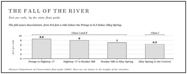
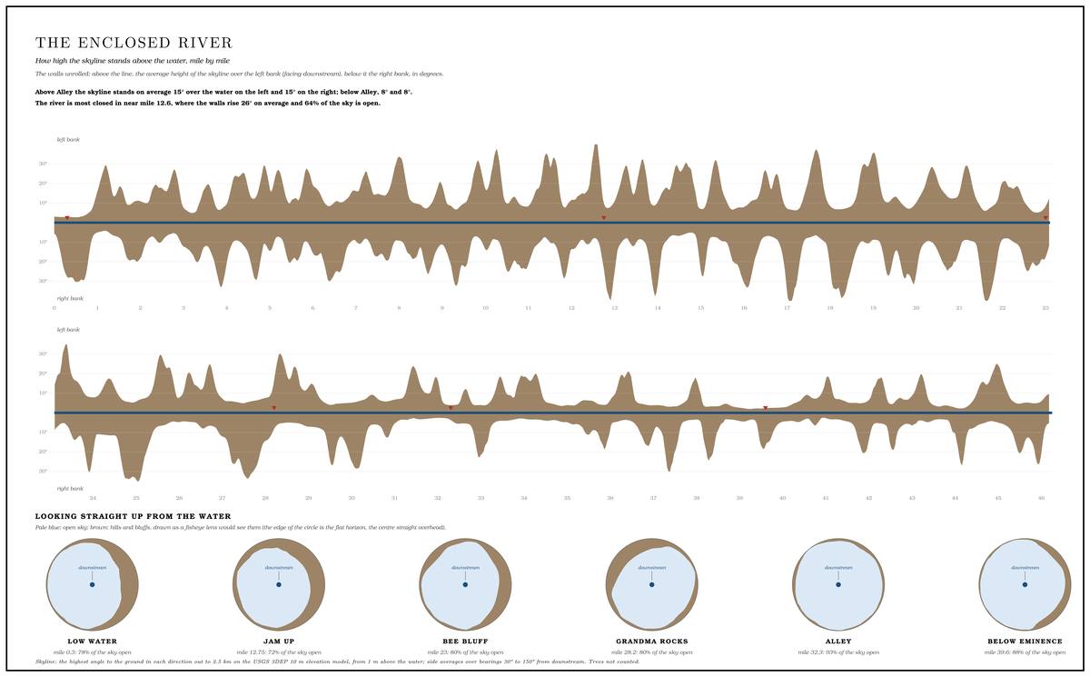
Measured along its bed, the river falls about 9 feet a milethe river profile measured on the 2021–23 riverbed survey (Heimann, Atkinson and High 2025; Map 12); see Chapter 2. The float guide gives 8.6 feet a mile from the Prongs to Highway 17, 8 to Bunker Hill, 7 to Alley Spring and 6.3 from Alley to the Current (general gradient 7.3), averages over its own stretches that agree with the measured fall to within about a foot a mile. from the Prongs to Highway 17, 8 on to Muck Forty Hole, 7 from there to just below Alley Spring, 6 on to Eminence and 5 from Eminence to the Current (Chapter 2). Over the seven miles to Highway 17 that comes to about sixty feetcomputed from the measured fall over the 6.98 miles from the junction to the Highway 17 bridge. of fall. The long Pool. A deep, slow stretch of river between riffles (Chapter 16). Glossary → lie nearly flat, and most of the fall comes in the riffles between them, so a boat moves in bursts. In its upper course the valley is close to a canyon, with no bottomland fields for its first twenty-five floatable milesMDC 2003 (“Its deep valley is nearly a canyon, with no bottomland fields for the first 25 floatable miles”)., and the channel swings from one bend to the next against the foot of a Bluff. A cliff along the river, usually on the outside of a bend, where the river has cut sideways into the hill. In this sense the word was first used in North America (Chapter 2; Chapter 18). Glossary →. At Low Water. The local name for the Highway Y bridge over the South Prong, the access beside it and the county’s low-water crossing where the prongs meet, and so for the head of the river (Chapter 8; Chapter 18). Glossary → in spring the stream, about thirty feet wide, squeezes in places into a frothing riffle no more than six feet across, with the gravel Bottom. The flat land along a river or creek, built of its deposits and open to its floods. In the 1920s the bottoms near Eminence averaged about a quarter of a mile wide (Chapter 2; Chapter 5). Glossary → only inches under the canoe, and as Missouri floats go the upper river is small, steep, fast and unusually clearDufur 2013, 18–19 (“The 30-foot wide stream has narrowed into a frothing riffle only 6 feet wide”; “scant inches above the gravel bottom”; “steeper, faster, tighter, smaller, and clearer than most river runs in Missouri”; a spring float, made when “The river is low”).. In April and May the stretch above Alley runs as Class II waterWindy’s Floats 2026..
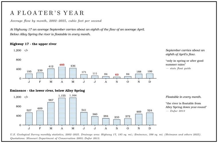
The upper river rises and falls with the rain. Above Alley the only large spring is Blue Springsee Chapter 12. (Chapter 12), and with nothing much to keep the river up between storms, the flow at Highway 17 in an average September is about an eighth of the flow in an average April, roughly 63 cubic feet a second against 485see Chapter 14, Table 14.1 (Highway 17, 2002–2025: April 485, September 63 cubic feet a second). (Chapter 14). Trips with loaded canoes above Alley are best kept to spring or to the weeks after good summer rainsMDC 2003 (“Trips with loaded canoes above Alley Spring are recommended only in spring or after good summer rains”).. In mid-to-late summer the water between Buck Hollow and Bay Creek usually runs low, which makes for harder floats and fewer peopleMDC 2026 (“water levels are traditionally lower from Buck Hollow to Bay Creek accesses, providing more challenging float trips, but also less river traffic”).. A Park Service folder of 1977 told floaters that the upper stretches of both rivers were “often more fun to float during late winter and springNPS 1977, “Floating the River” (general panel, of the upper stretches of both rivers). because in summer’s low water, portages have to be made around exposed Gravel bar. A bank of chert gravel and sand, usually on the inside of a bend, bare at low water (Chapter 15; Chapter 18). Glossary →.” Of the Jacks Fork above Alley in particular, the same folder said it “can be floated year-round if you have learned to ‘read’ the water currents and are prepared to sacrifice some aluminum from your canoe to the underlying rocks,” with springNPS 1977, Buck Hollow panel. the best time.
People who grew up on the upper river float it in summer too. A Mountain View resident who grew up at Arroll and has floated the stretch from the Prongs to Highway 17 many times names June through September as the best months and does not hold with the idea that the river above Blue Spring is worth floating only after a rain. The same floater counts the Prongs to Highway 17 the prettiest stretch on the river, and a harder float than Alley Spring to Two RiversJacks Fork Oral History, record SV-20 (raised at Arroll; on the best months, the prettiest stretch and the harder of Low Water to Highway 17 and Alley Spring to Two Rivers; disagreeing that “Above Blue Spring, the river is only worth floating after a rain”)..
Below Alley Spring the river changes character. Alley adds more water than the whole river above itsee Chapter 12. carries in a dry season (Chapter 12), and from there to the Current the Jacks Fork is Class I, wider and gentler, and floatable in every month. For a first-timer the same Mountain View floater would choose Alley Spring to EminenceJacks Fork Oral History, record SV-20.. A magazine writer who floated the upper Current in 1963Sports Illustrated 1963 (a float from Akers to Round Spring on the Current, with no byline shown: “So to my friends it is the prima inter pares of floaters’ rivers, though Jack’s Fork and the Eleven Point are not without their partisans”). said that among the writer’s friends the Current was first among equals of floaters’ rivers, “though Jack’s Fork and the Eleven Point are not without their partisans.”
Boats
The canoe has been the standard boat on the river since the 1960s, and in the counts of 1997 it made up nearly nine craft in ten (Chapter 9). It Draw. A valley, in the usage of the Eleven Point side of the divide in Howell County (Chapter 18). Glossary → little water, turns quickly in a tight bend and is light enough to drag over a Shoal. A fast, shallow, rocky stretch between pools; a riffle. Suckers crowd onto the shoals in spring, and the old saying is that “the dogwoods bloom when the suckers are shoaling” (Chapter 18; Chapter 19). Glossary →general explanation., which suits a riffle-and-pool river. The johnboat, long and flat-bottomed, has stayed the fishing boatNPS 1977, “Floating the River” (“long, flat-bottom boats that may be more suitable than canoes for fishing”)., and in the late 1990s most local people still did not fish from canoesGibson 2000, 39 (“Most local people did not and still do not fish from canoes”).. In the early 1980s about nine in ten floaters on the Riverways rented their boats locallysee Chapter 9 (Table 9.2 and the early-1980s studies). (Chapter 9). An Eminence Outfitter. A business that rents boats to floaters and runs their shuttles (Chapter 20). Glossary →’s fleet in 2026 ran to seventeen-foot canoes, twelve-foot single and fifteen-foot tandem sit-on-top kayaks (boats with the seat molded into the top of the hull), twelve-foot rafts for six people, inner tubes and tubes made to carry a cooler, and the business is authorized by the Park Service to rent johnboatsWindy’s Floats 2026. as well. Concessioners at Alley Spring and Two Riverssee Chapter 11. rent canoes and tubes inside the park (Chapter 11). The Mountain View floater from Arroll usually goes in a kayak, in normal water, and makes a few stopsJacks Fork Oral History, record SV-20. along the way.
By the early 2000s the wooden johnboat was all but gone from Ozark streams, and most float fishermen went in canoes or in aluminum johnboatsMcLaughlin 2001 (“The wooden john boats are all but gone from Ozark streams”; “Today, most float fishermen use canoes or aluminum john boats”), of Ozark streams generally. See Chapter 9. (Chapter 9). The aluminum johnboat, with a jet motor, a bank of lights and a rail across the bow, is also the giggers’ boatsee Chapter 19 (Turner 2014)., out on the river after dark in the fall and winter (Chapter 19).
The 1977 folder taught two paddle strokes, the “draw” and the “pry,” for steering around obstructions and keeping a boat parallel with the current. In a draw the paddler reaches out to the side and pulls the blade in toward the hull, which pulls that end of the boat toward the paddle, and in a pry the paddler sets the blade against the hull and levers it outwardthe two strokes, given as general explanation., which pushes that end away. The folder also named the beginner’s mistake in rough water: “‘barreling’ through, stroking furiously and using the paddle as a rudder.” When a passage looked too hazardous, its advice was to “step out and walk the canoe or boat through, or portage around,” and rangers held canoe demonstrations for beginners. Experienced floaters, the folder suggested, should think about trips of more than a dayNPS 1977, “Floating the River.”.
Putting in and getting back
The public accesses are few on the upper river and closer together below Alley (Table 20.1), for reasons of road and historysee Chapter 9. set out in Chapter 9. Most of the park’s backcountry sites are reached down gravel roads, and some of those roads are too rough for a car with low clearanceNPS 2026 (backcountry) (“down gravel roads”; “some roads are unsuitable for vehicles with low clearance”)..
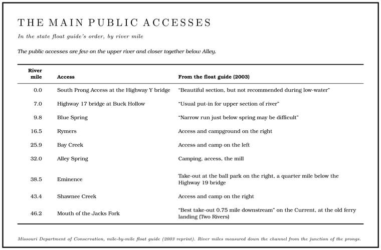
Other places along the river serve as accesses, among them the Backcountry campsite. One of the park’s designated camping places along the river away from the developed campgrounds. On the Jacks Fork they are at Blue Spring, Baptizing Hole, Bachers, Rymers, Bay Creek and Shawnee Creek (Chapter 11; Part Six). Glossary →see Chapter 11 and Reach D. near Blue Spring and below it (Chapter 11; Reach D). The Low Watersee Chapter 8. name and its crossings are described in Chapter 8. At Eminence the state keeps a public landing on the riverfront by agreement with its owner, the Joshua T. Chilton Memorial LandingMDC, Joshua T. Chilton Memorial Landing (Eminence); see Reach J. (Reach J). Access rules are in Part Six.
At high water some floaters start above the Highway Y bridge. Dixon Crossing, on the lower South Prong, was one place to begin until its owners closed it. “It’s possible to start at Dixon Crossing,” the Mountain View resident who grew up at Arroll says, “but most people start at The Forks,” the junction of the Prong. A branch or arm of a creek, set down in 1860 as Southern usage. The North and South Prongs join to form the Jacks Fork (Chapter 18). Glossary →, now called the ProngsJacks Fork Oral History, record SV-20 (“It’s possible to start at Dixon Crossing, but most people start at The Forks (Now it’s called the Prongs)”; of Dixon Crossing, “The new owners don’t let anyone enjoy it anymore”); see Chapter 8 and Reach B.. Another Mountain View resident, who moved there in 1979, also named the ProngsJacks Fork Oral History, record SV-05. as the place where high-water floats began. The land along the prongs is private.
Every float needs a way back to the vehicle. In 1977 the Park Service described the two choices that still hold: rental agencies took the rented canoes to the Put-in, take-out. The places where a float begins and ends (Chapter 20). Glossary → and picked them up with the floaters “at a scheduled time and place,” and floaters with their own canoes had to park “vehicles at both ends of the planned trip”NPS 1977, “Floating the River.” or arrange a Shuttle. The trip that brings vehicles from the put-in to the take-out, so floaters can get back (Chapter 20). Glossary → with an agency. With two vehicles, a party leaves one at the Put-in, take-out. The places where a float begins and ends (Chapter 20). Glossary →, rides in the other to the put-in with the boats, and at the end of the day drives back up for the first. On one two-day float a local outfitter shuttled the floaters’ own truck down to Bay CreekDufur 2013, 23 (published April 2013; the float itself is undated). while they were on the river. In 2026 an Eminence outfitter offered shuttles for private boats but noted that its insurance “does not allow us to move your vehicle,” so the arrangement had to be worked out ahead of time, and it asked its floaters to be off the river by 6 p.m. Sunday through Friday and 7 p.m. on Saturday.
The usual floats
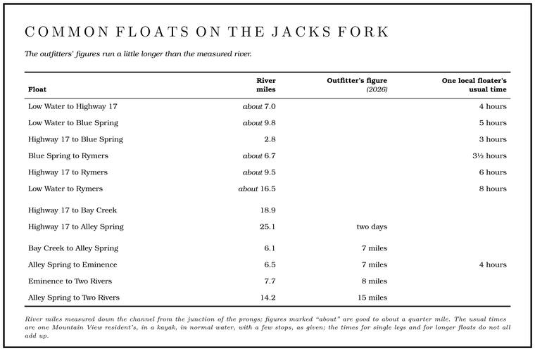
Every access pairs with the next one down, and a handful of pairings are the floats people make most often (Table 20.2).
On the upper river, the Park Service in 1977 called Buck Hollow “the favored access for a long, fast one-day Float trip. A trip down the river by boat, from a few hours to several days, with a way back arranged at the end (Chapter 20). Glossary → or a lazy, two-day trip to Alley Spring,” and an Eminence outfitter still sells “17 Bridge to Alley Spring” as a two-dayWindy’s Floats 2026. trip. Highway 17 to Bay Creek, about nineteen miles, makes a leisurely two-day float in springDufur 2013, 18 (“leisurely two-day canoe float”; his figure is “a distance of 18 miles”); measured along the river centerline, Highway 17 to Bay Creek is 18.9 miles.. The same outfitter rates the fishing on the Jacks Fork excellent and the twenty-five miles from the 17 Bridge to the Highway 106 bridge at Alley the best of it, and for want of accesses counts the upper river the most primitiveWindy’s Floats 2026 (“Fishing on the Jacks Fork is excellent. The 25 miles of river from 17 Bridge to Hwy 106 Bridge at Alley Spring, is best”; the sentence follows the one on fishing, so “best” probably means the fishing; “Due to lack of access, it is the most primitive of rivers in this region,” said of the upper river, the Prongs to Alley Spring); measured, 25.1 miles. in that part of the Ozarks. The canyon below Blue Spring is reckoned a premier spring float stream for smallmouth bass, sunfish and Goggle-eye. The river’s name for the shadow bass, a sunfish, and in the state’s rules for the rock bass and its kin. The name was in use by 1840 (Chapter 16; Chapter 18; Part Six). Glossary →MDC, Jacks Fork Natural Area (“one of the premiere spring time Ozark float streams,” for smallmouth bass, sunfishes and goggle-eye). (Chapter 16). Blue Spring to Rymers carries a boat through the Jacks Fork Natural Area, three miles of canyon with no road into itDufur 2013, 20 (“accessible only by canoe”)., and past Jam Up Cavesee Chapter 13 and Reach E. (Chapter 13; Reach E). The Mountain View floater finds Blue Spring to Rymers prettier than Rymers to Bay CreekJacks Fork Oral History, record SV-20..
Below Alley the outfitters’ standard listWindy’s Floats 2026. takes over: Alley Spring to Eminence, Eminence to Two Rivers, the two together, and Bay Creek to Alley or to Eminence. One Eminence outfitter in 2026 advertised twenty different trips on the Jacks Fork “depending on the water levels.” Bay Creek to Alley joins the bottom of the upper river to the top of the lower, and its last miles can be its slowest, since the few miles just above Alley Spring are especially wide and shallow and may have to be walked in low waterMDC 2003 (“the few miles immediately above Alley Spring are especially wide and shallow and may have to be walked in low water”)..
Old miles and new
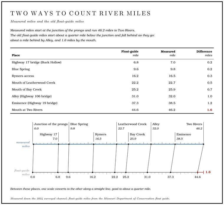
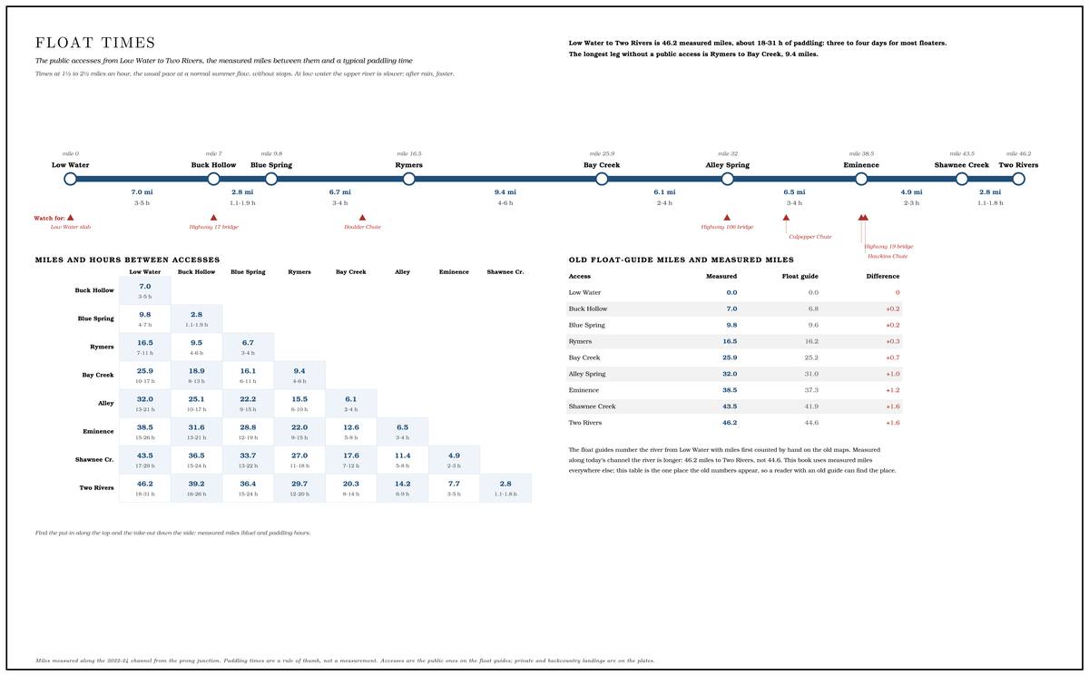
The standard float distances on the Jacks Fork come from the state’s mile-by-mile guide, which counts mile 0.0 at the South Prong access and reaches the Current at mile 44.6. Outfitters give their own, generally longer, figures. Measured along the surveyed channel, the river from the junction of the prongs to the Current is 46.21 miles long, and the old figures fall further behind the farther downstream they go: by Eminence the guide is about a mile and a quarter short, and by the mouth more than a mile and a half.
How long a float takes
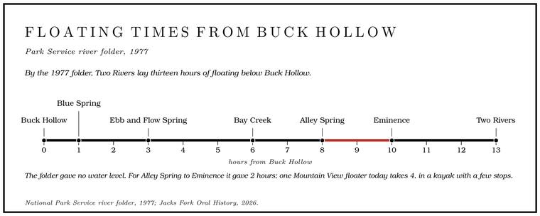
The 1977 folder gave average floating times from Buck Hollow: one hour to Blue Spring, three to Ebb and Flow Spring, six to Bay Creek, eight to Alley Spring, ten to Eminence and thirteen to Two Rivers. Those figures work out to roughly three miles an hour, and the folder did not say what water level it assumed. On the one stretch where the two can be compared, the Mountain View floater’s four hours from Alley to Eminence, a pace of about a mile and a half an hour, are twice the folder’s two. On a July 2013 float that began about a mile above the mouth of Alley Spring’s Branch. A small creek. The sense is American, on record from 1674 (Chapter 18). Glossary →, an Arkansas outdoors editor and his party took five hours, with stops for swimming and lunch, over what they reckoned at seven miles, about the same pace. The Mountain View floater allows for a few stops, thinks that “most people float too fast and miss the best of it,” is unsure whether the rental companies’ float times are about right, and finds the upper river getting harder to float because of gravel (Chapter 15).
Reading the water
In a riffle-and-pool river the decisions come in short stretches. A pool may run a quarter mile with the current barely moving, and then the water speeds up at the tail of the pool and runs through a riffle in a few seconds. Most of what a floater has to decide happens there. (How riffles, pools and barssee Chapters 2 and 15. form is explained in Chapters 2 and 15.)
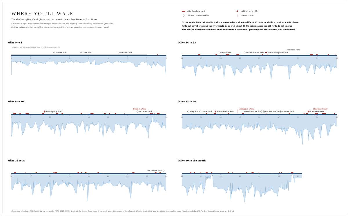
Chute. A narrow, fast slot of water through a shoal or past an obstacle. A smooth V of water pointing downstream marks the deepest path through it (Chapter 20). Glossary →. The 1977 folder put the basic lesson plainly. White water in a riffle means “rocks lie dangerously close to the surfaceNPS 1977, “Floating the River.” and you are about to enter a ‘chute.’” The way through is “the smooth water shaped like a ‘V’ pointing downstream,” which marks the deepest path between the rocks, and “the water in the chutes runs faster.” The V forms where the current funnels between two rocks or ledges and the water pours through the gap in a smooth tongue. A V that points upstream, with its tip toward the boat, usually means a rockgeneral explanation of reading moving water. just under the surface at the point.
Eddies. Below a rock, a gravel point or the end of a bar the current leaves a pocket of slack water that turns slowly back upstream along the bank. That Eddy. Slack water behind a rock, a gravel point or the end of a bar, turning slowly back upstream along the bank. In the 1930s speech of the Black River, an eddy was a still stretch between rapids (Chapter 18; Chapter 20). Glossary → is the place to stop, to bail, to wait for the rest of a party or to look over the next riffle before running it. The line between the eddy and the main current, where the two run in opposite directions, can catch the bow of a boat entering or leaving it and spin it, so a paddler crosses that line with the boat angled a little upstream and with some speed. A smooth hump of water piled against the upstream face of a rock, a pillowgeneral explanation of reading moving water., shows where the current strikes it.
Bends. On a bend the current swings to the outsidesee Chapter 2. and piles against the bank or the foot of a bluff. The deep water is there, and so are the undercut banks and the trees that fall from them. At low water the inside of a bend is often a shallow gravel bar, so the only channel deep enough for a boat may run straight along the outside, where the wood collects.
Wood. The folder’s warning was “Watch for rootwads!”, the exposed roots and trunks of fallen trees. “Water rushes under and through them; they can be disastrous for any craft that gets caught in the way.” Water passes through a tangle of roots and limbs, and a boat or a person carried into it does not, so the current can pingeneral explanation. either against the wood. The folder told floaters on tubes and air mattresses to be especially wary. Rootwads are “most common in the spring flooding season when trees lose their footing in the soggy banks,” and the folder advised asking a ranger where they had been seen. A floater who sees wood ahead early, watches whether the current runs into it and picks a line well above it has time to choose, and where the line is doubtful the folder’s advice to step out and walkNPS 1977, “Floating the River.” applies. A tree can come down in a single high water, so a bend that was clear one season may not be clear the next. Hazards and safetysee Part Six. are taken up in full in Part Six.
Hard places. The narrow run just below Blue Spring can be difficultMDC 2003, mile 9.6 (“Narrow run just below spring may be difficult”); see Reach D. (Reach D), and the last few miles above AlleyMDC 2003. may have to be walked in low water. Above Highway 17, the Mountain View floater who grew up at Arroll names the shoal at Panther Hollow as the hardest spot on the riverJacks Fork Oral History, record SV-20 (“the shoal at Panther Hollow”); see Reach C. to get through (Reach C).
Dragging. At low water the upper river has to be walked in places. The 1977 folder said there were “only a few thin shoalsNPS 1977, Buck Hollow panel. where you will have to step out and lead your canoe” between Highway 17 and Alley in spring, and that in summer “portages have to be made around exposed gravel bars.” Dorrance’s party dragged a loaded skiff over the shoals of the upper river in a drought summer, probably 1934see Chapter 9. (Chapter 9).
When to go
The winters are mild enough that the Riverways are in use almost the year aroundNPS 1977, “Floating the River” (“Mild winters allow almost year-round use of the Riverways”).. The three Geological Survey Gauge. A station of the Geological Survey that records the river’s stage, from which its flow is figured. The Jacks Fork has gauges at Highway 17, Alley and Eminence (Chapter 14). Glossary → on the Jacks Fork, at Highway 17, at Alley above the Spring branch. The stream that runs from a spring to the river, such as the branch below Alley Spring (Reach H). Glossary → and at Eminence, post their readings through the daysee Chapter 14. (Chapter 14). The gauge at Highway 17 is the one that matters most for the upper river. A rule of thumb for floating the upper Jacks Fork calls for 2 feet or more on the local gaugeDufur 2013, 23 (“Look for 2 feet or more on the local gage to float the upper Jacks Fork River”), the only source; the gauge is not named., most likely the one at the Highway 17 bridge. The reading measures the water’s height above the gauge’s own zero point, which is a different thing from its depthsee Chapter 14. (Chapter 14). The Eminence gauge carries Alley Spring’s watersee Chapter 14. and can read well when the upper river is too low to float (Chapter 14).
Floaters watch which way a reading is moving. A river at a good level and falling after a rain makes for a good float; the same reading climbing fast after a night of rain may be the front of a flood. Floods on the upper Jacks Fork rise quickly, and because weather moves east with the river, a storm over the prongs can raise the water under a floater who has seen no rain at allsee Chapter 14. (Chapter 14). At about 4 feet the Highway 17 gauge reaches what the National Weather Service calls Action stage. The lowest of the Weather Service’s flood categories, a gauge reading at about bankfull, when the river is near the top of its banks. At Eminence it is 6.4 feet (Chapter 14). Glossary →, about bankfullsee Chapter 14, Table 14.4.. Closures at high watersee Chapter 14 and Part Six. are covered in Part Six. Rain also raises the bacteriasee Chapter 17. in the river for a time afterward (Chapter 17).
Nights on the gravel
Many floaters spend the night on the river. The gravel bars that make the riffles also make the campsites, broad and open and often across from a bluff. Floods rework a bar often enough to keep most of it baregeneral explanation; see Chapter 15., and the state counts bars of this kind, which it calls gravel washes, as one of the natural communities of the Jacks Fork Natural Area, alongside its Dolomite. Calcium magnesium carbonate rock, a close relative of limestone, formed from lime mud on the floor of a warm, shallow sea. Nearly every bluff on the Jacks Fork is dolomite (Chapter 1). Glossary → cliffs and Glade. An opening where bedrock lies at or near the surface and the soil is too thin and dry for trees, usually on a south-facing slope (Chapter 16). Glossary → and its forestsMDC, Jacks Fork Natural Area (“gravel wash, dolomite cliff and glade,” forest and woodland and cave communities).. The immense gravel bar just below Jam Up Cave is a popular primitive camping siteDufur 2013, 23 (photo caption, “the immense gravel bar located just downriver from Jam Up Cave” as “a popular primitive camping site”).. An Eminence outfitter promises its overnight floaters nights spent sleeping “on gravel or sand bars”Windy’s Floats 2026. under “the brilliant Ozark stars.”
In the canyon above Alley a bar for the night should stand well above the river if there is any chance of sudden rainMDC 2003 (“camp well above river level if there is any chance of sudden rain”).. A narrow valley with no Floodplain. The flat valley floor that a river builds and floods (Chapter 2). Glossary → leaves rising water no room to spread, so the same flood stands higher against the wallsgeneral explanation; see Chapter 14. than it would in an open bottom, and a bar a few feet above the water at supper can be under it by morning. The 1977 folder said the same (“Pick campsites well above river level”NPS 1977, safety panel and “Floating the River.”), noted that “Flash flood. A sudden, fast rise of water after heavy rain, fed by quick runoff from steep slopes (Chapter 14). Glossary → warnings will be issued when possible,” and added a courtesy that still holds: “choose a campsite that can’t be seen from cabins or other structures along the river.” Where camping on the bars is allowedsee Part Six. and under what limits is set out in Part Six, and the park’s developed and backcountry campgroundssee Chapter 11. are described in Chapter 11.
Some people reach their camps by land. A Mountain View native remembered camping at RymersJacks Fork Oral History, record SV-06. as a child, riding in an uncle’s Jeep “across neighbors fields to get there.”
One June camp on the upper river lay on a gravel bar under a towering wall of gray dolomite, with boulders the size of cars, fallen from the bluff, resting in deep green water across the river and a riffle gurgling below the bar. A conservation writer who spent the night there and described it in 2026 heard bullfrogs, a green frog and trilling toads from the wet spots on the bar and from a warm sloughBullard 2026, 18 (Loring Bullard, in the state’s conservation magazine; the campsite is not named and the year of the night is not given). behind it, and later a barred owl and a screech owlBullard 2026, 20.. Night-sky darkness is graded on a nine-step scale that the amateur astronomer John Bortle published in 2001, where one is the darkest sky on earth and nine the sky over a city center. At class two the Milky Way is bright enough to show structure and clouds show only as black gapsBortle 2001; the scale is given as general explanation. among the stars. He rated the sky over that bar a little over two, saw the Milky Way stretch from horizon to horizon after midnight, and knew of few places in MissouriBullard 2026, 20 (“There are few places in Missouri with a Bortle rating as low as this stretch of the Jacks Fork”). with so dark a sky. Besides red headlamps, satellitesBullard 2026, 19. and passing planes, the only artificial light he noted was “the faint skyglow from Mountain View, a small city about 5 miles to the southwest.” The Mountain View floater who grew up at Arroll has floated the Jacks Fork at nightJacks Fork Oral History, record SV-20 (agree, “I’ve floated the Jacks Fork at night”)..
Leaving it as found
An Eminence outfitter offers every boater a trash bag and asks floaters to pack outWindy’s Floats 2026. what they pack in, and a volunteer stream teamsee Chapter 9. works on the upper river (Chapter 9). The rulessee Part Six. that govern the river itself, from motors and fishing limits to camping, caves and closures, change from year to year and are collected, with their dates, in Part Six.