On a hot July afternoon below Steel Bridge, a floater drifting close under the Bluff. A cliff along the river, usually on the outside of a bend, where the river has cut sideways into the hill. In this sense the word was first used in North America (Chapter 2; Chapter 18). Glossary → will now and then pass through a pocket of air so cold it raises goose bumps. Look up, and there is usually a dark opening somewhere in the rock: a slot at the waterline, a low arch with a fan of fallen rock spilling toward the river, a Hole. Any pool deep enough to swim or fish in, named or not, the basic unit of the river in local speech; also “hole of water” (Chapter 18). Glossary → high on the cliff where only the vultures go. The cold air is coming out of the hill.
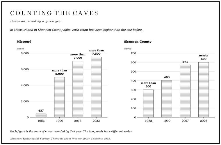
The Jacks Fork runs through cave country. About ten miles of its banks are bluff 50 feet tall or more, eight of those miles above Alley, and the tallest faces stand 280 to 350 feetmeasured on the flood-mapping terrain (Heimann, Atkinson and High 2025; Map 13); see Chapter 2. over the water (Chapter 2; Map 13). Missouri has more than 7,500 known cavesColatskie 2023., and Shannon County, which holds most of the river, has nearly 600 of them, a number only Perry CountyMSS, “Shannon County.” beats. When cavers working for the Missouri Speleological Survey and the National Park Service went over the Jacks Fork valley in the early 1980s, they wrote up fifty-seven caves and Rock shelter. An overhang wider than it is deep, with no passage behind it. Many held the camps of the first people (Chapter 3; Chapter 13). Glossary → and named a few moreMSS 1982, contents and reports (fifty-four reports with text, three with a map only, and six caves named without a report). they had heard of or glimpsed. Most are small. Across Missouri, fewer than 3 percentWeaver 2008, 127. of known caves run longer than a mile, and on the upper Jacks Fork a cave of a few hundred feet counts as ordinaryMSS 1982, 34 (“an average length cave for the upper Jacks Forks Valley”)..
A cave, in the cavers’ working sense, is an opening that runs deeper into the hill than it is wide. A rock shelter is the reverse, an overhang wider than it is deepWeaver 2008, 6., with no passage behind it. The Jacks Fork has plenty of both, and the line between them is often a matter of a few yards of crawlway.
Rock that dissolves in the rain
The caves exist because the bedrock dissolves. The hills along the upper river are built of Dolomite. Calcium magnesium carbonate rock, a close relative of limestone, formed from lime mud on the floor of a warm, shallow sea. Nearly every bluff on the Jacks Fork is dolomite (Chapter 1). Glossary →, a close cousin of Limestone. Calcium carbonate rock formed from lime mud and shells on a sea floor. Most of the limestone laid down here later became dolomite (Chapter 1). Glossary → made of calcium and magnesium carbonate, which gives way to acid a little more slowly than limestone does. Rain falling through the air picks up a little carbon dioxide, and it picks up a great deal more as it soaks through leaf litter and soil, where roots and rot keep the ground air rich in the gas. The water becomes a very weak carbonic acidNPS, speleothems (Ozark); Weaver 2008, 125.. When that acid meets dolomite, it turns the carbonate of the rock into bicarbonate, which stays dissolvedThornberry-Ehrlich 2016, 13. in the water and travels off with it. The rock leaves in solution, molecule by molecule, and none of it has to be worn away. Against dolomite that is enough, given time (Chapter 12).
Southern Missouri gets about forty-five inches of rainThornberry-Ehrlich 2016, 13. a year, and a good share of it soaks into the ground instead of running off. That water travels through the rock along its cracks: the vertical Joint. A crack along which rock has split without moving. In the riverways the main sets run north-south and east-northeast (Chapter 1). Glossary → that split the bedrock into blocks, and the bedding planesWeaver 2008, 126., the seams between one layer of rock and the next. Wherever water moves, it eats a little of the rock and widens its own path. A hairline crack becomes a tube the width of a pencil, then a pipe, then a passage a person could crawl through. Water that stands still soon takes up all the rock it can hold and stops dissolving, so the work goes fastest where the water keeps moving, and the steep fall from the Ozark uplandsThornberry-Ehrlich 2016, 13–14 (dissolving water soon reaches saturation; a steep hydraulic gradient between the uplands and the valley floors keeps it moving). down to the valley floors keeps it moving. The process is slow beyond any human patience, and it never stops. Missouri has been called a “cave factory,” because the region may now be in the most intense episode of cave making in its entire geologic history.
Geologists have argued about how and where this happens. Into the twentieth century the textbook view was that caves are carved above the Water table. The level below which every crack and pore in the ground is full of water (Chapter 12; Chapter 13). Glossary →, the level below which every crack and pore in the rock is full of water, by streams running through open passages. In 1930, in a long paper on the origin of limestone cavernsDavis 1930., the geographer William Morris DavisWeaver 2008, 110–111. proposed the opposite, that caves are dissolved below the water table in rock that is full of slowly moving water, and only later drained and opened to the air. J Harlen Bretz of the University of Chicago came to the Missouri Ozarks in 1947 to test the idea, crawled through cave after cave, and came away convinced that Davis was right. His Caves of Missouri, published by the state geological survey at Rolla in 1956Bretz 1956., became a classic. He is remembered as a great teacher with a fine sense of humor. His parents had given him no first name, so he added a J in front of Harlen, and since it stood for nothing he wanted no period after it. “Throughout all my life,” he said, “I have fought typists and printers to leave off that damned period.”
Both kinds of cave are now known to form. Some passages grow below the water table beneath a layer of sandstone, where groundwater under pressure is held against the underside of the layer and dissolves the rock just below it. Others, the more common kind, grow above a sandstone layerThornberry-Ehrlich 2016, 13–15., where water seeping downward reaches the sandstone, cannot get through it, and runs along its top. Cavers call a passage dissolved in water-filled rock phreatic, and one shaped by a stream running through it in open air vadose, and a single cave can be both. Jam Up Cave probably beganMSS 1982, 35 (report of the 1960s: “considerable vadose alteration of the original cave, which must have been phreatic”). as a phreatic cave and has since been much reworked by the stream that runs through it (Reach E). In the Ozarks the dissolving began high in the rock column, in the Jefferson City Dolomite that caps the uplands, and worked deeper over hundreds of thousands of yearsThornberry-Ehrlich 2016, 15. as the land was worn down. Cave making in the region has been going on for tens of millions of years. Many of the caves that are dry and open today drained and filled with air somewhere between a few hundred thousand and perhaps two million years agoWeaver 2008, 125–126..
The level where caves form
On the upper river the caves keep turning up at the same level in the rock. One entrance sits about twenty feet below the base of the RoubidouxMSS 1982, 4. Formation, and another passage lies less than fifty feet below itMSS 1982, 10.. Several caves sit right at the contactMSS 1982, 34, 49. between the Roubidoux and the Gasconade Dolomite beneath it, the line in the rock where one formation ends and the next begins.
The reason is the sandstone. The lowest beds of the Roubidoux are sandstone, which barely dissolves, and the top of the Gasconade is dolomite, which does. Groundwater moving through the hills is held against the underside of that sandstone and spreads sideways along it, dissolving the top of the Gasconade just beneath. The sandstone becomes the ceilingMSS 1982, 4, 29, 34; Thornberry-Ehrlich 2016, 14–15., and the passage follows the contact along the bedding, sometimes for long distances. In Bunker Hill Cave, between Rymers and Bay Creek, a two-foot layer of sandstone shows in the fallen rock at the climb into the biggest room, and sandstone turns up again at the far end of the cave, the source of the sand in its stream. Along the way the stream runs over scalloped bedrock and a floor of sandy gravel that often becomes pure white crystalline sand, and the passage loops back and forth in a way more typical of the caves of Pulaski CountyMSS 1982, 21–22 (“a meandering characteristic more typical of Pulaski County caves than Shannon County caves”). than of Shannon County.
Near Blue Spring the contact lies about 900 feet above sea level. Seventy to eighty feet below it, a three-foot bed of fossil algal mounds called the cryptozoon reef forms the floor of a cave entrance just above the waterline, where the ledge juts out into the river (Chapter 1). The reef is a marker bed, a layer that can be recognized from bluff to bluff, and because the top of the Gasconade usually lies seventy to eighty feet above itMSS 1982, 13., the reef shows where the contact ought to be even in a bluff where the contact itself is hidden.
Deeper in the rock lies a thicker and more important lid, the Gunter Sandstone at the base of the Gasconade. The most complex cave networksThornberry-Ehrlich 2016, 14–15. in the region formed beneath it. Alley Spring comes out of one of these. Divers have mapped more than 3,000 feetThornberry-Ehrlich 2016, 12. of flooded passage behind the spring Pool. A deep, slow stretch of river between riffles (Chapter 16). Glossary →, down to at least 155 feet below the surfaceMDC, Alley Spring Natural Area.. Water held under the Gunter is under pressure from the higher ground around it, and where the sandstone has been broken through, that pressure drives the water up out of a lower cave passageThornberry-Ehrlich 2016, 13 (fig. 8: “hydrostatic pressure from a confined aquifer forces the water from depth up to the surface”), 18. and into the pool (Reach H).
Plumbing left high and dry
As the Jacks Fork cut its valley deeper, the water table in the hills fell with it, since groundwater drains toward the lowest outlet it can reach, and on the upper river that outlet is the river. Passages that had once been full of water were left dry and open, high in the bluffsWeaver 2008, 125–126., while new passages kept growing below at the level where the water stood. So a single bluff can hold a dry cave near its top and a spring at its foot. The dry caves are old plumbing, and the springs are the plumbing in use.
Blue Spring shows both at once. The spring itself comes out of a cave at the base of the bluff, from a Rise pool. A spring pool fed from beneath, where the water wells up from a lower cave passage, as at Blue Spring (Chapter 12; Chapter 13). Glossary →, where the water wells up from below, probably twenty feet deep or moreMSS 1982, 16.. Just upstream in the same bluff is Hospital Cave, probably an older outlet of the same system. As the water found a deeper way out, the old outlet was abandoned to the air, and its dry passages probably give a fair idea of what lies behind the springMSS 1982, 34 (“Hospital Cave originally developed as an outlet for the ancestral Blue Spring system”; “The cave offers a good look at what may be found if Blue Spring were penetrated”). itself (Reach D).
Water also leaves its signature on the walls. Fast water flowing over soluble rock carves it into Scallop. A shallow, spoon-shaped hollow carved in a cave wall by fast water. Smaller scallops mark faster flow, and the steep end of each faces upstream (Chapter 13). Glossary →, shallow spoon-shaped hollows that overlap like the scales of a fish. Each one starts where a small Eddy. Slack water behind a rock, a gravel point or the end of a bar, turning slowly back upstream along the bank. In the 1930s speech of the Black River, an eddy was a still stretch between rapids (Chapter 18; Chapter 20). Glossary → in the current lingers against the rock and dissolves a little more there than around it. Their size tells how fast the water was moving, with smaller scallops marking faster flow, and their shape tells which way it went, since the steep end of each scallop faces upstream. About 110 feet into Moss Spring Cave, between Rymers and Bay Creek, the scallops in the floor are so sharp that kneepads and gloves are needed to keep from being cut, and the party that mapped the cave in 1981 named that stretch the Meat GrinderMSS 1982, 44 (“About 110 feet into the cave the scallops in the floor are so sharp that kneepads and gloves are needed to avoid getting cut”)..
The river can also break into a cave from the outside. One cave in a bluff above the Jacks Fork was a pocket packed with clayMSS 1982, 56. until the river, cutting down, reached it and opened it. Floodwater has since flushed out much of the clay and left silt in its place. Other caves near river level fill with every big rise. One has a cracked silt floorMSS 1982, 11 (“often flooded by the river judging from the cracked, silt floor”). that shows how often the river floods it, and another is frequently backfloodedMSS 1982, 13., the rising river pushing in at its mouth and filling it from the front.
How caves fall apart
Once a passage is drained, it begins to come apart. Underwater, the rock of a ceiling is partly held up by the water around it. Drained, each slab carries its full weight, and slabs crack loose along the joints and fall, a process cavers call Breakdown. The falling of slabs from a cave’s ceiling and walls along their joints once a passage drains and the rock bears its full weight. Breakdown made much of Jam Up Cave’s river entrance (Chapter 13). Glossary →. Jam Up Cave’s enormous river entrance owes most of its size to it, and great blocksMSS 1982, 34. still lie across the opening (Reach E). Ceiling falls have happened at Jam Up in recent yearsNPS 2026 (Jam Up).. In many of the small caves along the Jacks Fork, the blocks on the floor probably never fell at all. They were loosened where they lie, weathered apart in placeMSS 1982, 13..
Breakdown can carry a cave all the way to daylight. A passage near the surface loses its roof a slab at a time until a Section. A square mile of 640 acres, one thirty-sixth of a township. A quarter section is 160 acres (Chapter 5). Glossary → caves in, leaving a Sinkhole. A hollow in the ground where rock below has dissolved or caved in, through which water drains underground; also called a sink, an American use (Chapter 2; Chapter 12). Glossary →, a natural bridge, or a short tunnel open at both ends. In the riverways, sinkholes in the lower Roubidoux have collapsed through its basal sandstoneThornberry-Ehrlich 2016, 19. into caves in the Gasconade below. In one shelter the back wall is a heap of broken rock that has slid down along a joint and is still unstable. The movement will probably go on until it opens a hole to the surface, and then an arch will stand there with the joint forming its far side, as so many natural bridges and arches doMSS 1982, 61 (the shelter is “a good example of 1 way in which natural bridges or arches form in the Ozarks”; “a natural bridge will exist as do so many in the Jacks Fork drainage”). in the Jacks Fork drainage. Jam Up, strictly speaking, is a Natural tunnel. A cave open at both ends. Jam Up is a natural tunnel (Chapter 13; Reach E). Glossary →MDC, Jacks Fork Natural Area., a cave open at both ends (Reach E).
Caves also steal water. A cave growing beneath a creek can open a way through the creek bed, so that the creek drops underground and leaves its old channel dry. Cavers call this Stream piracy. The capture of a creek’s water by a cave growing beneath its bed. Jam Up Creek was captured this way by Jam Up Cave (Chapter 13). Glossary →. Jam Up Creek, which heads in Mountain ViewUSGS NHD; Imes and Fredrick 2002., was captured in this way by the cave beneath it, and its flow was diverted undergroundMSS 1982, 35 (report of the 1960s: “Jam Up Creek was captured by the lower cave, diverting the stream flow underground”).. In wet weather the creek runs into Jam Up Cave and comes out again at the river entranceMSS 1982, 34–36; Johnson 2007, 27–29. (Reach E). The water that sinks in the creek’s bed below Mountain View never comes back to the Jacks Fork at all. It turns up at Big SpringImes and Fredrick 2002. on the Current (Chapter 12). At Blue Spring a sinkhole that opened over the old spring system captured a whole hollow, and the cleft it left cut a pinnacle of rock loose from the bluff, which cavers call the rock islandMSS 1982, 28. (Reach D). Bear Cave, on the stretch between Low Water and Steel Bridge, probably pirates waterMSS 1982, 4. from a neighboring hollow.
Stone that grows
A cave that has been drained does not stay bare. Water still seeps down through the rock overhead, carrying dissolved calcite, and when a drop reaches the open air of a cave, it gives off some of its carbon dioxide, the way a bottle of soda fizzes when the cap comes off. With less carbon dioxide in it, the water can no longer hold all of its calciteNPS, speleothems (Ozark)., and a thin film of crystal is left behind on the ceiling, the wall or the floor. Cavers call the results Speleothem. Any mineral formation in a cave, such as a stalactite or flowstone (Chapter 13). Glossary →, or just formations. Pure calcite is white. Iron, manganese and the tanninsThornberry-Ehrlich 2016, 16. of rotting leaves, carried down in the water, stain it red, orange, brown, gray or black.
Every Stalactite, stalagmite. A stalactite hangs from a cave ceiling, built from dripping water. A stalagmite builds up from the floor where the drip lands (Chapter 13). Glossary → begins as a Soda straw. A hollow calcite tube the width of a drop of water, hanging from a cave ceiling. Every stalactite begins as one (Chapter 13). Glossary →, a hollow tube of calcite exactly the width of a drop of water, hanging from the ceiling. Water runs down the inside and adds a ring at the tip. When the tube clogs, water runs down the outside instead, and the straw thickens into the familiar icicle shape. Where the drip hits the floor it builds a Stalactite, stalagmite. A stalactite hangs from a cave ceiling, built from dripping water. A stalagmite builds up from the floor where the drip lands (Chapter 13). Glossary → up toward it, and if the two meet they make a column. Water running down a sloping ceiling leaves a line of calcite that grows into a thin, folded drapery, sometimes banded like bacon. Water flowing across a floor or wall lays down Flowstone. Calcite laid down in layers by water flowing across a cave floor or wall (Chapter 13). Glossary →NPS, speleothems (caves program). in layers. In shallow pools, calcite builds Rimstone. Calcite dams built around the edges of shallow cave pools (Chapter 13). Glossary → dams around the edges, and grains of sand kept turning under dripping water become coated, layer after layer, into cave pearls. Helictite. A cave formation that twists off in any direction, fed by water seeping through tiny internal canals (Chapter 13). Glossary → twist off in any direction at all, fed by water seeping through tiny internal canalsNPS, speleothems (Great Basin); NPS, speleothems (caves program). too fine for gravity to matter.
The Jacks Fork’s caves hold their share. Hospital Cave has an upper level with soda straws. Simpson Hole Cave, below Steel Bridge, had soda straws and draperies when cavers went through it in 2007. Moss Spring Cave has rimstone dams, a natural arch, a six-foot waterfall, and a shelf twenty-five by Forty. Forty acres, a quarter of a quarter section. A hill farm was often one or two forties (Chapter 5). Glossary → feetMSS 1982, 44. set with small stalagmites. In one small cave elsewhere on the river, the floor pools that once held cave pearls have dried, and by the early 1980s the pearls were mostly crushed or otherwise disturbedMSS 1982, 26.. The caves of the Riverways region as a whole hold helictites, aragonite crystals, cave pearls, massive flowstone, boxwork, golden calcite and unusually long soda strawsWeaver 2008, 138.. Some of the park’s caves also hold spathites, which are uncommon in caves outside the park: tubular stalactites built up as a stack of delicate, overlapping cones shaped like petalsThornberry-Ehrlich 2016, 17 (“not common to caves outside the park”)..
How fast formations grow depends on how much water is moving and on the rainfall and the temperature outsideNPS, speleothems (Ozark)., and the rates vary from cave to cave and from century to century. In human terms they barely grow at all. Formation is extremely slow, and damage done to it can stay in sight for generationsNPS 2024 (caves and karst) (“extremely slow, and physical damage may remain in evidence for generations”).. A broken stalactite does not heal, and the oil left by a hand can keep new calcite from forming on that spot. Formations also keep a record of the past. An earthquake can snap a stalactite or topple a stalagmite, and dating such breaks can give the dates of old earthquakes. Formations in Round Spring CaveThornberry-Ehrlich 2016, 17. on the Current are being studied for exactly that.
Ozark folk belief gave formations a reputation of their own. Stalactites and stalagmites were held to be somehow deadlier than any other stones, and even a slight blow from a piece of “drip rock”Weaver 2008, 119, quoting the folklorist Vance Randolph, Ozark Superstitions (1947): “an odd belief that stalactites and stalagmites are somehow deadlier than any other stones, and that even a slight blow from a piece of ‘drip rock’ is generally fatal.” was generally thought fatal. Others were less nervous. Between about 1885 and 1925, when cave picnics and dances were popular all over the Ozarks, visitors routinely broke off formations to take home. In the hot months somebody would lay a dance floor back inside a cave, out of the heatWeaver [n.d.] (“In the hot summer months, somebody would build a dance floor back inside of a cave”).. Stalactites ended up on mantels and in rock gardens, and stalagmites were even set up as tombstonesWeaver 2008, 80–81.. As early as 1898 a writer on Ozark cavesWeaver 2008, 82, quoting Luella Owen, Cave Regions of the Ozarks and Black Hills (1898). complained that most of them had “been deprived of great quantities of their beautiful adornment by visitors.”
Caves that breathe
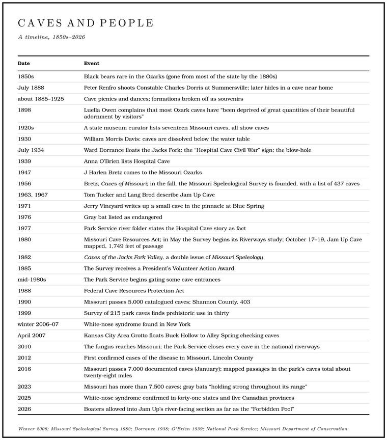
Floating down from Mountain View one July, probably in 1934Dorrance 1938 gives no year; see Chapter 9., Ward Dorrance met a man “a-muleback”Dorrance 1938, 31. somewhere between Blue Spring and Jam Up. The man tied his jenny to a tree and led the floaters up a hill to what he called a blow-hole: “an aperture twenty-four inches across in the rock of a hill, the ‘skylight,’ evidently, of a cave.” The air pouring out of it was cold enough to bend the Branch. A small creek. The sense is American, on record from 1674 (Chapter 18). Glossary → around it and whip the leaves.
Dorrance had guessed right. Away from its entrances, an Ozark cave holds a nearly steady temperature the year around, somewhere between about 56 and 60 degreesWeaver 2008, 31. Fahrenheit. That is close to the average temperature of the whole year outside, because the rock deep in a hill, insulated by everything above it, settles at the year’s average and holds it through summer and winter alike. On a summer day the air in the cave is colder and heavier than the air outside. If a cave has openings at different heights, the cold air drains out of the lower ones like water from a tipped jug, and warm air is drawn in at the top to replace it. In winter the flow reverses, and the cave breathes in at the Bottom. The flat land along a river or creek, built of its deposits and open to its floods. In the 1920s the bottoms near Eminence averaged about a quarter of a mile wide (Chapter 2; Chapter 5). Glossary → and out at the top, where its warmer, moist air can show as a plume of vapor on a cold morning.
The breath of a cave can give it away. In summer a cascade of cool air plunges down the hollowMSS 1982, 18 (“In summer a cascade of cool air plunges down the hollow, alerting one to the cave’s presence”). from Bunker Hill Cave and gives the cave away. In Hospital Cave a steady wind blows through a squeeze about a hundred feet in. Jerry Vineyard felt that wind around 1971 and suspected a big cave system lay beyond it, and Scott House, who mapped the cave a decade later, felt it and thought the same, until the mapping showed an average cave for the river, 375 feet long with three entrancesMSS 1982, 32 (“I, like Vineyard, noted a strong blast of air and surmised, as he had, that there may be a large cave system here. I was wrong.”), 34..
The caves and the springs
Spring outlets of any size are cave openings that discharge groundwaterWeaver 2008, 6.. The big springs of the Ozarks are the outlets of cave systems that collect water from wide areas of country and bring it out at the foot of a valley. Some of the oldest caves in the region are probably the deep, water-filled conduitsWeaver 2008, 125. that feed those springs, still in the Stage. The height of the water surface above a gauge’s datum, the reading a gauge records. A stage differs from the depth of the water. At Eminence the datum stands 616.18 feet above sea level (Chapter 14). Glossary → of growth that the dry caves in the bluffs passed through long ago.
Both of the Jacks Fork’s great springs come out of caves. Blue Spring, one of the larger springs in the Current River basin, rises in a pool inside a caveMSS 1982, 16. at the base of its bluff (Reach D). Alley Spring, one of the largest springs in Missouri, sends out water from its flooded cave at a rate given as 81 million gallons a dayThornberry-Ehrlich 2016, 17; NPS 1977. A local history of 1980 gives 80 million (Lewis 1980, PDF p. 53). and, from the Gauge. A station of the Geological Survey that records the river’s stage, from which its flow is figured. The Jacks Fork has gauges at Highway 17, Alley and Eminence (Chapter 14). Glossary → records, about 87 millionsee Chapter 12 (135 cubic feet a second, the mean of the gauge record). (Chapter 12). Rain that falls into sinkholes around Summersville, about fifteen miles to the northwest, travels through cave passages under the hills and comes out at Alley. Under the Alley Spring Natural Area those passages hold some of the richest cave lifeMDC, Alley Spring Natural Area. known in the state (Reach H).
The connection runs both ways. Whatever goes into a sinkhole or a cave goes into the groundwater, and from there into a spring or a well. For generations sinkholes and caves in the riverways country were used as dumps and as outlets for septic systemsThornberry-Ehrlich 2016, 39–42., and the water carried the results downhill under the ground (Chapter 17).
Life in the dark
More than 1,100 kinds of animals have been recorded in Missouri’s caves, among them mammals, birds, fish, amphibians and reptiles as well as a great many smaller creatures. A cave is three different places for them. The entrance zone, out to the dripline where rain falls from the overhang, is still half outdoors. Just inside it is the Twilight zone. The part of a cave inside the entrance, where some daylight reaches and the air still swings with the weather. Outside it the entrance zone runs out to the dripline, where rain falls from the overhang, and deeper in lies the dark zone, with no light at all and nearly steady temperature and humidity (Chapter 13). Glossary →, where some daylight reaches and the air still swings with the weather. Deeper is the dark zoneColatskie 2023., where there is no light at all and temperature and humidity hardly change.
The animals sort themselves roughly into three groups. Some only visit, sheltering in the cave but feeding outside: bats, wood rats, the eastern phoebesMSS 1982, 11. that build their mud-and-moss nests on ledges in shelter mouths, and the vultures that roost in high openings. Some can live either in caves or in cool, damp places outside, such as cave crickets, many salamanders and the small flies that cluster on cave ceilings. A few live only underground. Biologists call these Troglobite. An animal that lives only underground, usually pale and eyeless, with long feelers (Chapter 13). Glossary →. They are usually pale and eyeless, with long feelers and slow lives. In total darkness, color and eyesight do an animal no good, and over many generations cave animals lose them and rely on touch and smell instead, while a slow life suits a place where food comes seldom. They live on what water and visitors bring in from outside: leaves, flood trash, bat droppings and the dung of wood rats. With no sunlight in the dark zone, no green plants grow there, so every animal in it depends in the end on food carried in from the surface.
The Jacks Fork’s caves have their full share of the visitors and the part-time residents. Wood rat nests turn up in cave after cave, along with cave crickets, two kinds of spider in one cave, a brown recluse in another, hibernating bats, and heliomyzid fliesMSS 1982, 11, 18, 49, 51, 56, 58. on the walls. Cavers in Jam Up Cave in the 1960s saw cave salamanders and a long-tailed salamanderMSS 1982, 35.. Moss Spring Cave is notable for the beauty of its many formations and the variety of its life. In 1981 it held big brown bats, the small bats then called eastern pipistrelles, a frog, cave crickets, salamanders and amphipodsMSS 1982, 44 (“notable for the beauty of its many formations and its diversity of life”)., small shrimplike crustaceans that live in cave streams.
The cave salamander is the one a careful visitor is most likely to notice, a bright orange salamander, usually spotted with black, that lives mostly in the twilight zone and climbs cave walls with its wet body, using its long tailMDC, “Cave Salamander.” to brace itself on formations. The grotto salamander is stranger. Its larvae have working eyes, darker skin and broad tail fins, and they sometimes live in small streams and springs outside caves. The adults are pale tan or pink, with small eyes partly or fully covered by their eyelids, and they live in total darkness in caves with streams running through them. A larva may take two or three years to turn into an adult, sometimes as long as six, and an adult lives at least nine years in the wild. The larvae will occasionally eat bat guano, and the species is most abundant in caves with many bats, probably because of the insects that the guano Draw. A valley, in the usage of the Eleven Point side of the divide in Howell County (Chapter 18). Glossary →. The grotto salamander lives nowhere outside the OzarksMDC, “Grotto Salamander” (the northern grotto salamander, Eurycea nerea, and the southern, E. spelaea, “separated as distinct species based on genetic analysis”)., and on genetic evidence it is now divided into two species, a northern and a southern grotto salamander.
The rarest life is in the water. In the mid-1930s Dorrance saw three blind fish in the pool of Blue Spring’s cave, probably southern cavefish, which were recorded at one site in the Jacks Fork basin in 1992Dorrance 1938, 29; Wilkerson 2001, 27. (Reach D). What was once called the southern cavefish has since been split into several species that look nearly alike, and the cavefish of the Missouri Ozarks’ Salem Plateau, the country the Jacks Fork drains, is now called the Salem Plateau cavefish. It is a small fish, an inch and a half to two and a half inches long, with a long, flattened head and no eyes, and it has so little pigment that the blood under its skin makes it look pinkish white. It eats tiny crustaceans, small crayfish and the larvae of water insects, and its slow metabolism lets it go a long time between meals. It is believed to spawn when the water is high, from February through April, and the female carries her eggs, as many as fifty, in her gill chamber for four or five months until they hatch. A cavefish probably lives more than ten yearsMDC, “Salem Plateau Cavefish” (Typhlichthys eigenmanni; the department’s field guide gives the range as the underground waters of the central and southern Ozarks and the lifespan as unknown but “believed to be longer than 10 years”). That the Jacks Fork’s cavefish are this species is inferred from that range..
The Salem cave crayfishWilkerson 2001., a pale crayfish that lives underground and turns up at the mouths of large springs near the limit of daylight, has been recorded in the watershed and is ranked as imperiled across its whole range. That range lies entirely in Missouri, in a broad band of the eastern Ozarks from Camden and Crawford counties south to Oregon and Ripley, and includes the Current and Eleven Point drainages. The crayfish is blind and a translucent white, two and a quarter to nearly four inches long, with long, narrow pincers and very long feelers. An animal with so small a range, living in water that comes down from the surface, can be badly hurt by a single accident, and in 1981 one fertilizer spill that seeped into the ground killed thousandsMDC, “Salem Cave Crayfish” (it “occurs within our borders and nowhere else in the world”; the spill “seeped into the ground and wiped out thousands of these animals”; the field guide does not say where). of them. Under the Alley Spring Natural Area at least seven troglobites live in the cave passages, including the grotto salamander, and Branson Cave there is one of the most biologically diverse cavesMDC, Alley Spring Natural Area (“one of the most biologically diverse caves known in Missouri”). known in Missouri.
The bats. The cave animal with the most at stake on the Jacks Fork is the gray bat. Missouri holds about a fifth of the whole species, and the latest statewide count came to 541,518MDC 2026 (bats), 52 (table 18, current gray bat count, from the department’s statewide bat database, 2022). gray bats. Gray bats depend on caves the year around, using warm caves that trap heat for their summer nurseries and cold caves that trap cold air for the winter. A cave traps warm air where its ceiling rises into domes higher than its entrances, since warm air rises and has no way out, and the packed bodies of the mothers add their own heat. It traps cold air where its passages run downward from the entrance, since cold air sinks and settles. The bats are choosy about it: across the species’ entire range, 98 percent of gray bats hibernate in just fifteen caves, packed into colonies that can number in the hundreds of thousands. In summer they hunt over water, following rivers and streams out to their feeding grounds and catching insects on the wing, including the Asiatic oak weevils that swarm in the forested cliffs along rivers. The species has been recorded in the Jacks Fork watershedWilkerson 2001..
Gray bats were listed as endangered in 1976, after their numbers fell sharply, mainly because people disturbed their roosts. They are extremely sensitive. Even someone walking carefully through a cave with a light can send them into the air, and a single disturbance can wreck a colony’s breeding for the year. Protecting their caves has worked. The species is still listed as endangered but is recovering wellMDC, “Gray Myotis (Gray Bat)” (“a single disturbance can wreck a colony’s reproduction for the year”)., and by 2023 it was holding strong throughout its rangeColatskie 2023..
The endangered Indiana batNPS 2023 (caves). also uses caves in the riverways. It was on the first federal list of endangered species, published in March 196732 Fed. Reg. 4001.. In winter it needs a cave that holds steady at about 40 degrees and stays damp, and there hundreds of bats pack into a few square feet of ceiling. In summer it leaves the caves for the woods along streams, where it roosts under loose bark on trees such as shagbark hickoryMDC, “Indiana Myotis” (“cool caves with stable temperatures of around 40F and relative humidity of 66–95 percent”).. That summer habit carried the bat’s protection out of the caves and into the timber. At the end of the 1990s the Indiana bat was the subject of a quarrel over timber salesGibson 2000, 86–87 (“the current controversy over the Indiana bat, an endangered species found in caves in the ONSR area”), the only source for the timber man’s account. in the Ozarks, and a local timber man described it from the woods’ side. “They found a few bats in the bat caves,” he said, and while the government studied whether cutting timber harmed the bat, “they shut all these sales down.” He wondered why the boats did not count against the bat as well: “the caves are right next to the rivers.”
The small bats once called eastern pipistrelles are now called tricolored bats, for the three colors banded along each hair. They hibernate alone or in pairs rather than in colonies, and in damp caves they are often found beaded with dewMDC, “Tricolored Bat.”. All of these bats live on insects, and by one estimate of 2011, losing North America’s bats would cost the nation’s agriculture more than $3.7 billion a yearBoyles and others 2011. in crop and forest pests.
Bears. Before settlement black bears were common in the Ozarks, and bones from Missouri caves show that they routinely wintered in caves, often in groups. They were rare by the 1850s and gone from most of the state by the 1880s, but they left their name behind. Forty-three Missouri caves have “Bear” as the first word of their names, plain Bear Cave being the most common of them, and Shannon County has eleven “bear” caves, more than any other county. The Bear Cave on the stretch between Low Water and Steel Bridge is one of the larger caves in the valley, about 550 feet long, with a stream passage that runs back to a pool where the ceiling meets the waterMSS 1982, 2, 4.. Black bears have since come back into the southern Missouri Ozarks from ArkansasWeaver 2008, 25–29..
Older bones lie deeper. Caves in the riverways country have yielded remains of animals from the last ice age, among them the giant short-faced bear, probably the most dangerous bear Missouri ever hadWeaver [n.d.] (“probably the most vicious and dangerous bear that we had living in Missouri”)., jaguar, a stilt-legged deer, the dire wolf and a giant armadillo. The dire wolf came from Powder Mill Creek CaveThornberry-Ehrlich 2016, 28–29. on the Current River side of Shannon County.
What people did with caves
Before settlement. People were using Ozark caves and rock shelters for thousands of years before the first settlers arrived. A dry shelter in a bluff above a river offered a ready camp, out of the rain and the wind and close to water and game. Caves were also sources of Chert. A hard, fine-grained form of silica that forms in nodules and beds inside dolomite and stays behind when the dolomite dissolves. Most Ozark people call it flint. It makes up the river’s gravel and was the stone of the first people’s tools (Chapter 1; Chapter 3). Glossary → for tools, of clay for pottery, and of water, and some held burials. About a third of Missouri’s known rock-art sitesWeaver 2008, 6–9. are on the walls of caves and shelters. By the late 1990s, 215 caves on fourteen tracts across the park’s main Karst. Country shaped by dissolving rock, with caves, springs, sinkholes and losing streams. About 99 percent of the national riverways is karst (Chapter 1; Chapter 12). Glossary → formations had been examined for signs of people, and thirty of them showed prehistoric use and nineZedeño and Basaldú 2003, 13, after Price and Hastings 1999, 19–22. historic use (Chapter 3). Dry cave deposits can preserve things that rot away anywhere else, because with no water and little moving air the molds and bacteria of decay can barely work. At Arnold Research Cave in central Missouri they kept shoes woven from plant fiber for about nine thousand yearsWeaver 2008, 8..
Those deposits are what looters dig into. Deep holes in the entrance room of Bear Cave are probably the work of amateur archaeologistsMSS 1982, 4 (“deep holes, probably a result of amateur archaeologists”).. A cave floor builds up in layers, the oldest at the bottom, and what a site can tell depends on which layer each thing lay in and what lay beside it. Digging the floor for arrowheads churns the layers together, so that the record of when people were there and what they did is gone, and the damage cannot be repaired. Disturbing a human burial in Missouri, marked or unmarked, is a felonyRSMo 194.410..
Farm and home. For the families who settled the hollows, a cave with a spring in it was a cellar, a cooler and a water supply. Rural electricity reached parts of the Ozarks only in the early 1950sWeaver 2008, 31., and until then the steady cold of a cave did the work of a refrigerator. Milk, butter and cheese set in a trough of cold spring water kept far longer than they would in the house. Families walled up cave entrances to keep out animals, hung doors in the walls, and built small dams inside caves or across their mouths to hold back the spring stream. Caves were still being turned into Springhouse. A small building over or beside a spring, where cream, milk, butter and meat were kept cool (Chapter 12). Glossary → and water supplies as late as the 1950s. More than two hundred Ozark caves still show the evidence: crumbling dams, walled entrances, pipes, troughs, shelving and old water tanks. Shannon and Texas counties are both on the list. Caves also kept potatoes and apples through the winter. Shannon County has a Potato Cave, and Texas County has two Sweet Potato CavesWeaver 2008, 31–35..
Just inside the mouth of Blue Spring’s cave are the broken remains of a concrete dam, by one account dated 1938Lewis 1980, PDF p. 23, the only source (“A concrete wall across the entrance is dated 1938”); see Reach D., whose purpose is unknownMSS 1982, 16 (“the purpose of which is unknown”)., and by 2007 an old retaining wallJohnson 2007, 24. had fallen into the rise pool. No record yet says who built them or why (The Open Ledger). Dams like it were a common way to pool a cave spring for water or cooling.
War, stills and treasure. During the Civil War, caves in the riverways country were dug for saltpeter to make gunpowder, used to hide county records, and used as refugesThornberry-Ehrlich 2016, 3., and some stories of those years have attached themselves to Jacks Fork caves (see “The stories,” below, and Chapter 6). Saltpeter, potassium nitrate, is the part of gunpowder that feeds the burning, and the dry earth of an old cave floor, enriched over centuries by the droppings of bats and wood rats, holds nitrates. Diggers carried the cave dirt out and soaked it in hoppers, ran the water through wood ashes, which turn the nitrates into saltpeter, and boiled the liquor downgeneral (the old leaching method of making saltpeter from cave earth). until crystals formed. Across the Ozarks making saltpeter and gunpowder this way was a cottage industryWeaver [n.d.] (“gunpowder manufacturing and saltpeter mining was a cottage industry in our Ozarks”).. A cave with a spring in it was also an ideal place for a still: cold water, steady temperature, shade and privacy. More than forty caves in Missouri, spread over twenty-three counties, have a surviving story or physical trace of brewing or moonshining, three of them in Shannon CountyWeaver 2008, 45.. In one Jacks Fork cave lies the base of an old copper kettle, rusted through, quite possibly the remnant of a still. Moonshining was very active along the Jacks ForkMSS 1982, 49 (“quite possibly the remnant of a onetime moonshine operation”; such operations “were very active along the Jacks Fork before, during, and after the prohibition period”). before, during and after Prohibition, the years from 1920 to 1933 when making and selling liquor was against federal law.
Ozark caves attract treasure stories, and more than one Missouri cave is named for them. The stories usually involve Spanish gold, Civil War loot or a lost silver mine, a hidden room and a map, and by the legends Jesse James hid out in nearly every cave in the stateWeaver [n.d.] (“the legends down there you would think that Jesse James hid out in every cave in Missouri”).. Camped on the Current near Van BurenDorrance 1938, 43–45, the only source (told at the campfire of Leo Anderson, a Current River man; the cave of the story is on the Current and is not named here). in the mid-1930s, Dorrance listened to the hill people’s treasure talk, of buckskin maps, Pine knot. The base of a pine limb where it grows into the trunk, so full of resin that it outlasts the rest of a dead tree and burns hot and bright. Pine knots lit the gigging boats, burning in a fire box or metal basket called a firejack in the middle of the boat (Chapter 19). Glossary → buried in significant positions and arrows scratched on walls. To hear some of the hillmen tell it, there was no cave “in which Frenchman or Spaniard, Confederate or Yankee, or simple train robber, did not bury treasure.” One of the stories he heard was about the people who cannot dig it. Old Jake Hepburn, the story went, came to the mouth of a cave hunting gold, and at once the wind blew, the day grew dark and the earth trembled under him. He caught his mare and left, decided on reflection that it had been a plain, ordinary earthquake, and went back, and before he could get out of the saddle he was driven off the same way. The teller finished: “Yessir, Leo, I reckon they’se folks that hadn’t better go foolin’ around with no treasure diggins.”
The bedrock of the Ozarks does not hold veins of gold or silver, and no one has ever found treasure in a Missouri cave. The digging, though, has done real harm, wrecking archaeological deposits and fossils and leaving spoil pilesWeaver 2008, 70–75, 138 (a statewide count of caves named for treasure). behind.
Visitors. Before 2010 most of the park’s caves were open to anyone who could reach them, and people used them hard. By 1981 many people went into the front rooms of Bunker Hill Cave, and at least one vandal with green spray paintMSS 1982, 22. had already reached the back. That same year the squeeze in Hospital Cave’s passage was already polished by the passage of many bodiesMSS 1982, 32.. By 2007 its floor was packed hard by foot traffic, and the dripstone there had turned brownerJohnson 2007, 23–24. than it was four years before. Simpson Hole Cave held the remains of a campfire and some broken formations that year, and the cavers who went through it then thought it visited heavily enough to need a gateJohnson 2007, 22–23 (“highly visited”; the party suggested a gate). (Reach D). Volunteers from the Springfield Plateau Grotto and the Cave Research Foundation have since reattached at least seventy-eight broken formations in Shannon County caves and filled in looters’ holes, and restoration work has been done in up to thirteen caves. The Park Service began putting gates on some entrances in the mid-1980sThornberry-Ehrlich 2016, 39–42.. A well-built cave gate is a grid of steel bars spaced so that bats can fly through it and people cannot.
The stories
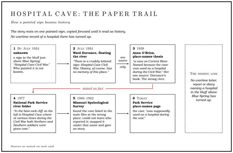
Hospital Cave. The best-known cave story on the Jacks Fork is a Civil War story, and its paper trail is short enough to follow to the end. On his float of the mid-1930s Dorrance passed a “yawning hole in the bluff”Dorrance 1938, 29. just above Blue Spring and wrote: “There is a crudely lettered sign: Hospital Cave Civil War. History, of course, has no memory of this place.” Then he imagined wounded soldiers by candlelight anyway.
Five years later Anna O’Brien, a University of Missouri graduate student collecting the place names of five south-central Missouri counties, listed Hospital Cave as “a cave on Current River. Named becauseO’Brien 1939, 62. the cave was used as a hospital during the Civil War.” Her one source was Dorrance’s book, the same passage in which he had said history had no record of the place, and she put the cave on the wrong river. By 1977 the Park Service’s river folder stated the story as fact: “In the bare-rock cliff on the leftNPS 1977. is Hospital Cave where at various times during the Civil War both Northern and Southern soldiers were given care.” The Park Service’s place-names page now says the cave “was supposedly used as a hospital during the war.”
The cavers of 1980 to 1982 found Hospital Cave listed in the state cave files at the wrong place, up a hollow in rock much less likely to hold caves, and could not learn who had reported itMSS 1982, 32.. They mapped it under that name and gave no story for it. Nobody has yet established who painted the sign or what they had heard (The Open Ledger). No wartime letter, report or diary naming a hospital in the bluff above Blue Spring has turned up, though wartime hospitals did exist in the region, among them the courthouse at Old Eminence on the Current in February 1863Eddleman 2022. (Chapter 6).
Meeting House Cave. Downstream between Jam Up and Rymers, Meeting House Cave opens with one of the largest entrances on the river and about 220 feet of passageJohnson 2007, 30–31. behind it (Reach E). The 1977 Park Service folder gave its story as legend from the start: “According to legendNPS 1977., this cave was used as a hideout by both sides during the war.” By another account it was a meeting place in the troubled daysLewis 1980, PDF p. 30 (“was used as a meeting place during the troubled days of the War Between the States”). of the War Between the States, and the name is generally said to come from the Civil War periodNPS 2015 (place names) (“takes its name from the Civil War period”).. Elsewhere in Missouri, Union and Confederate forces did sometimes use a cave entrance as a meeting pointWeaver [n.d.] (“Sometimes the Union and Confederate forces would use a cave entrance as a rendezvous point”).. In older American usage a meeting house was also a house of worshipMerriam-Webster, “meetinghouse.”, and the name may remember a church gathering as well as a war councilthe name is not among the Civil War names O’Brien collected in Shannon County (O’Brien 1939, 155–156), and the cave survey of 1980 to 1982 does not mention the cave. (The Open Ledger).
Peter Renfro. The cave story with the best documents behind it belongs to Peter Renfro, whose name is also spelled Renfrow, a man from near Summersville. On July 18, 1888, about six in the evening, at Summersville, he shot and killed Constable Charles D. DorrisState v. Renfrow 1892 (“on the eighteenth day of July, 1888, in the town of Summerville, Texas county, Missouri, about six o’clock in the afternoon”); the Missouri Memorial roll gives the same date and hour. Eddleman 2026 gives July 25.. The accounts agree on the killing, on a cave near home where Renfro hid out, on a break from the Springfield jail, on his capture in 1898MSS 1982, 49; Weaver 2008, 52; Eddleman 2026., and on a governor’s mercy at the end. They disagree on many of the dates in between (The Open Ledger).
In the fullest telling, drawn from the newspapers of the time, Renfro and his brother Will confronted John Hughes, a witness in a lawsuit against Will. Dorris arrested Will, and Peter, drunk, drew a pistol and shot the constable over the left eye. Dorris died within the hour. Renfro gave himself up five days later and was moved to the Springfield jail on a change of venueon the term, standard legal usage., which sends a trial to another county when a fair jury is unlikely at home. With his trial set for late 1889, he broke out with other prisoners and went to ground in a cave near home. Its mouth was on the face of a cliff, reportedly reachable only from aboveEddleman 2026; Weaver 2008, 52.. He kept a Winchester, two revolvers and a dog, and friends brought him food. After about a year two of his cousins and a deputy sheriff dropped on him from above while he slept at the cave mouth, and he was back in Springfield on August 6, 1891.
He was convicted and sentenced to hang, and on October 10, 1892, the Missouri Supreme Court upheld the convictionState v. Renfrow 1892. The Missouri Memorial roll puts the affirmance in November 1892.. Stays pushed the date back to February 7, 1893, and in late January 1893Eddleman 2026, a broadcast history drawn from the newspapers of the time. he escaped again in a mass break from the Springfield jail. That summer the Current WaveEddleman 2026, citing the Current Wave, June 29, 1893. ran a story on his cave hideout, and a newspaper account of 1893 described the hideout but would not say where it wasWeaver 2008, 53.. In February 1898 a deputy U.S. marshal arrested Renfro at the old Doniphan club house in northern Ripley CountyEddleman 2026; Weaver 2008, 53., where he had married and settled, though a Michigan paper that month placed the capture in Lawrence County, ArkansasAnn Arbor Argus 1898..
Back in Springfield he was sentenced to death a second time. A petition went around southern Missouri asking for mercy, and the evidence suggested drink and Temper. Material mixed into clay to keep a pot from cracking. Here it was sand, crushed limestone or crushed mussel shell, and the choice helps date a sherd, a broken piece of pottery (Chapter 3). Glossary → rather than a plan. In May 1898 Governor Lon V. Stephens commuted the sentence, to life by one accountWeaver 2008, 53 (May 12, 1898); MSS 1982, 49. and to twenty-five years by another. By the second account Governor Alexander Dockery cut the term to end in May 1905 after another petition, and that summer the Springfield paper reported Renfro at an Independence Day barbecue and wished him a useful, settled life. He is buried near SummersvilleEddleman 2026 (May 17, 1898)..
At least two caves carry his name. Peter Renfro Cave is about 220 feet long and very hard to find, even in winter, and the rusted kettle lies in it. The government topographic map shows the cave in the wrong place, a local resident once said the “real” Peter Renfro Cave was on a different hillside, and Renfro had so many caves to choose from that he probably used severalMSS 1982, 24, 46, 49 (“very difficult to find, even in the winter”).. A second, Peter CaveMSS 1982, 49., is reportedly named after him as well.
Mapping the caves
For most of Missouri’s history nobody had any idea how many caves the state held. A state museum curator in the 1920s compiled one of the first lists and came up with seventeen, all of them show cavesWeaver 2008, 109.. In the fall of 1956 three men, Oscar Hawksley, a biology professor at Warrensburg, Frank Dahlgren, a St. Louis metalworker, and Jerry Vineyard, then a geology graduate student at the University of Missouri, came home from a national caving convention in Nashville and founded the Missouri Speleological Survey to locate, record, explore, map and study the caves of Missouri. They started with a list of 437 known caves. The Survey arranged with the state geological survey at Rolla to keep its maps and reports in a permanent repository, and over the next fifty years its members added more than 120 caves a year to the state’s files. In 1985Weaver 2008, 110–117. the Survey received a President’s Volunteer Action Award at the White House for that work.
Vineyard, born in 1935 near Dixon, had grown up in the hills of Pulaski County. In 1957 he was one of four compilers of the state survey’s Catalogue of the Caves of MissouriVineyard and others 1957., and he spent forty years with the state’s geologists at Rolla, retiring as assistant state geologist. With a federal hydrologist, Gerald Feder, he wrote Springs of Missouri, first published in 1974Vineyard and Feder 1982 (revised edition of Springs of Missouri)., and he remained a caver, with a particular interest in the cave survey, until he died in 2017Vineyard obituary 2017.. Hawksley, the biology professor, also wrote the float guide Missouri Ozark Waterwayssee Chapter 9. (Chapter 9).
Mapping a cave is slow, wet, careful work. A survey team moves through the cave from one station to the next, measuring the distance between them with a tape and the direction and slope with a compass and clinometer, while one member sketches the walls, floor and ceiling at each station. Back home the numbers are reduced to a line plot and the sketches drawn up over it into a finished map. Cavers name what they find, often for what they see or for what happened to them there. One party in 1975 named a cave for a place in The Lord of the RingsMSS 1982, 26., and the name was later dropped as “not appropriate.”
In May 1980 the Survey began a study of the caves of the Ozark National Scenic Riverways for the National Park Service, directed by R. Scott House. By 1982 its teams had found nearly a hundred cavesMSS 1982, 1. in Texas, Shannon and Carter counties that had never been catalogued. The Jacks Fork results filled a double issue of the Survey’s journal, Missouri Speleology, titled Caves of the Jacks Fork Valley and edited by William R. Eddleman. In the early 1980s the Survey and the Cave Research FoundationWeaver 2008, 116. also inventoried caves on other government lands across the state.
The work was done mostly in winter, when the leaves are down and a cave mouth can be seen across a hollow. Cavers from the Southeast Missouri Grotto were already mapping caves in the Leatherwood Creek valley in December 1979MSS 1982, 23, 39, 48.. On December 29, 1980, House, Eddleman and Mike Wetzel worked the caves around Buck Hollow and Blue Spring, and they dated their reports New Year’s DayMSS 1982, 15, 18–19.. Robert L. Taylor, Chris King and Mike Younkin spent October 17 to 19, 1980, mapping Jam Up Cave and measured 1,749 feetMSS 1982, 36 (map). of passage. Other names recur on the maps: Joel Laws, Jerry Wagner, Leonard Butts, George Katich. The issue gathered older reports too. Tom Tucker and Lang Brod had described Jam Up in April 1963 and August 1967MSS 1982, 34–37., and Vineyard had written up a small cave in the pinnacle at Blue Spring in March 1971MSS 1982, 28..
Some of the reports have the dry humor of people who have crawled a long way for very little. One small cave was “barely worth the effort.” Of a cave with a waterfall near its stream, a surveyor wrote, “Some people feel that the waterfallMSS 1982, 51–52. feeds the cave stream but I believe that the stream feeds the waterfall.” Getting into some of the caves took real nerve. At one bluff cave reached by a vertical climb of fifteen or twenty feet, only one member of a party of four made it up, and he got back down “by leaping into the limbs of a treeMSS 1982, 43–44. and sliding down the trunk.”
Some leads came from the Park Service. In 1975 a park employee, Loyd RainboltMSS 1982, 26, 51., steered cavers to one well-hidden cave, and a room in another cave was later named for him. The valley of Leatherwood Creek, which comes in below Rymers, yielded about twenty caves and shelters to the survey. Its owner had posted the land, and the Survey printed the request plainly: nobody should visitMSS 1982, 1, and the Leatherwood Creek reports, 24–61.. The issue closes with the society’s motto in capital letters, “CONSERVE MISSOURI’S CAVES.”
A generation later the caves were still being checked. In April 2007 a party from the Kansas City Area Grotto, nine people in four canoes and a kayak, floated twenty-four miles from Buck Hollow to Alley Spring in three days with a list of caves from Scott HouseJohnson 2007, 20., then working for the Park Service. They looked for each cave, recorded where it was, photographed it, and noted the animals in it and the damage people had done. By 2016 the mapped passages in the park’s caves added up to about twenty-eight milesThornberry-Ehrlich 2016, 12..
Counting the caves
Every count of caves on the Jacks Fork and in Shannon County is a count of what had been found and recorded by a certain date, and the numbers rise as cavers keep searching. A partial catalogue of 1952 gave names and locations for 210 caves in all of Missouri. The catalogue of 1957 counted 686 caves in fifty-seven counties, with 25 in Shannon County, 26 in Texas County and 3 in HowellVineyard and others 1957, introduction and table 1.. In 1982 Shannon County had “over 300”MSS 1982, 1. known caves. In 1990, the year Missouri passed 5,000 catalogued caves, the county had 403Thomson 1990., by April 2007 it had 571Weaver 2008, 138., and it now has nearly 600MSS, “Shannon County.”. Missouri passed 7,000 documented caves in January 2016MSS 2016. and had more than 7,500Colatskie 2023. by 2023. The caves identified inside the national riverways are given as more than 300NPS 2023 (caves). and as more than 400. At the higher figure the riverways hold more caves than any other unit of the National Park System, sixty of them with permanent streams and sevenThornberry-Ehrlich 2016, 12. with lakes. The state’s natural heritage records list twenty-three cavesWilkerson 2001, from the Missouri Natural Heritage Database. in the Jacks Fork watershed itself.
The closure
In the winter of 2006 to 2007Colatskie 2023., hibernating bats in New York were found dying with a white fuzz on their muzzles and wings. The fuzz is a fungus, Pseudogymnoascus destructans, that grows in the cold, damp air of the caves and mines where bats hibernate. A hibernating bat lets its body cool nearly to the temperature of the cave and slows its heart and breathing, and in that state the fat it put on in the fall can carry it to spring. The fungus wakes the bats again and again through the winter, each waking means warming the body back up, and every warming burns fat they need to last until spring. Whole colonies starve. The disease, called White-nose syndrome. A fungal disease that wakes hibernating bats again and again until they starve. The fungus reached Missouri in 2010, and the park closed its caves that year (Chapter 13). Glossary →, has killed millions of bats, and by the end of 2025 it had been confirmed in forty-one states and five Canadian provincesUSGS 2025.. It is about 90 percent fatal to the bats that catch it. It does not affect people, but people can carry the sporesNPS 2023 (caves). from cave to cave on boots, clothing and gear.
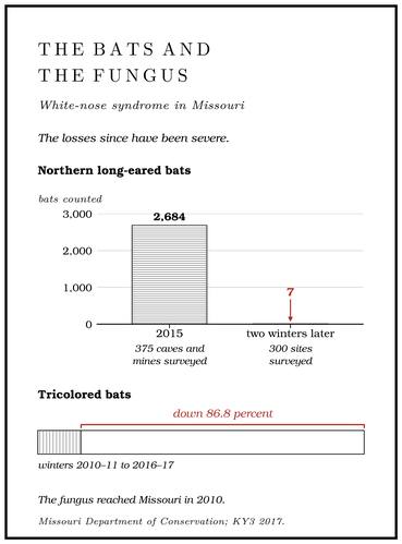
The fungus reached Missouri in the spring of 2010. In April it was found on a little brown bat in a privately owned cave in Pike County. In May researchers found it on five gray bats and a northern long-eared bat netted outside a public cave in Shannon County, though none of them was yet sick. The first confirmed cases of the disease in Missouri came in 2012, in Lincoln CountySt. Louis Public Radio 2012; MDC 2011., north of St. Louis: a little brown bat from one public cave and two tricolored bats from another, confirmed by the federal wildlife health laboratory at Madison, WisconsinMDC 2012 (bats).. The losses since have been severe. Missouri’s tricolored bats declined by 86.8 percentMDC, “Tricolored Bat.” between the winters of 2010–11 and 2016–17. Surveys of 375 Missouri caves and mines in 2015 counted 2,684 northern long-eared bats, and a survey of 300 sites two winters later found sevenKY3 2017..
The Park Service did not wait for the disease to arrive. In 2010 it closed every caveNPS 2023 (caves); Thornberry-Ehrlich 2016, 39–42. in the national riverways to visitors, “all caves along the Current and Jacks Fork Rivers,” whether gated or not. Apart from Jam Up, the exceptions are on the Current: the guided lantern tours of Round Spring Cave, led by park staff, Big Spring Cave, which is open, and Cave Spring, open as far as the shade lineNPS 2025 (compendium), § 1.5(a)(1). inside its mouth. Devils Well, a karst window where the roof of a cavern fell in over an underground lakeNPS 2024 (caves and karst). about 400 feet long and up to 200 feet deep, one of the largest cave lakesThornberry-Ehrlich 2016, 12 (after Vana-Miller 2007). in the country, is seen from a platform reached by a stairwayNPS 2018 (Devils Well), which gives the lake as much as 80 feet deep. and is not entered (Part Six).
The 1977 river folder had sent floaters to Jam Up to see “a falls and pool inside the cave.” Jam Up is partly open again. As of 2026 the Park Service allows visitors arriving by boat into the river-facing sectionNPS 2026 (Jam Up). of the cave as far as the pool at the foot of its underground waterfall, the “Forbidden Pool,” and asks them to go no farther (Reach E).
What a cave can do to a person
Caves are hard on people. The temperature barely changes, the water in a cave stream is as cold as the rock, and wet clothes draw heat from the body far faster than dry ones, so a wet, chilled caver can slide into hypothermia in what feels like a cool room. Beyond the twilight zone the darkness is total, and a party that loses its lights is in serious trouble, which is why experienced cavers carry at least three dependable sources of lightWeaver 2008, 127. apiece. Floors are slick with mud and littered with breakdown, passages pinch down to crawls, and reaching many entrances on the Jacks Fork means a climb up a crumbling bluff or a scree slope. Caves near river level and caves that take in creeks flood quickly in heavy rain. Large logs clutter the Jam Up Creek entrance of Jam Up Cave, and cavers in 1963 could see that it floods during heavy rainsMSS 1982, 35 (Tucker, April 1963: “Many large logs clutter this entrance, and it obviously floods during heavy rains”)..
The law, and the silence about locations
About seventy percent of Missouri’s documented caves are on private land. Among cavers it is the caver’s own responsibility to find out who owns a cave and to get permissionMSS, “Privately Owned Lands.” before going in.
On park land the closure carries the force of federal regulation, and violating a park closure is itself an offense36 C.F.R. § 1.5(f).. Missouri’s Cave Resources Act of 1980Weaver 2008, 116. protects caves on any land. Breaking, carving or marking a cave’s walls or formations without the owner’s written permission is a class A misdemeanor, and so is breaking into or tampering with a cave gateRSMo 569.135., whether or not the person goes in. Using a cave or spring to dispose of sewage, trash or chemicals is a separate offenseRSMo 569.137.. The federal Cave Resources Protection Act of 1988 covers significant caves on federal land. Damaging one, removing anything from it, or entering it intending to do either can bring up to a year in prison for a first offense and three years16 U.S.C. § 4306. for a second.
The same federal act bars agencies from releasing the specific location16 U.S.C. § 4304. of a significant cave unless doing so would further its protection without putting it at risk. Saying little about where caves are is an old custom. In 1893 a newspaper accountWeaver 2008, 53. described Peter Renfro’s hideout and kept its location to itself. The Speleological Survey keeps its maps and location files with the state geological survey, and it published its 1982 survey of the Jacks Fork with a request that nobody visitMSS 1982, 1. the valley where it had found the most caves. When the first confirmed cases of white-nose syndrome turned up in Lincoln County in 2012, the names and locations of the two caves were withheldSt. Louis Public Radio 2012..