In a drought summer of the 1930s a Chicago woman who had just bought a farm in Texas CountyLyon 1941, ch. 10. was taken to see the Jacks Fork, “crystal-clear, ice-cold,” a mile from the house, and told the tradition of the hills: “If you take a drink of water from Jack’s Forks, you will always come back to the Ozarks no matter how far you roam.” Marguerite Lyon took a big gulp and laughed, sure she would never see the place again. She had been an advertising copywriter in Chicago, and she and her husband, Robert, a salesman, had paid $1,000 for the farm after a scare about their jobs over Labor Day of 1935. They stayed. Robert served as the local justice of the peace, the couple started a jelly business with fruit from the neighborhood that grew into a small factory in Mountain View, and Marge Lyon wrote a book about their life in the hills, Take to the Hills (1941). A reviewer in the Mountain View Standard did not care for the way it drew the neighborsMcConnell, “Marge Lyon” (the review by Verna Springer in the Mountain View Standard; Lyon died in 1965), the only source for these details..
For most of its history the Jacks Fork was a working river. It watered the stock, turned the mills, carried the ties and stopped the mail. Between the coming of the railroad and the creation of the national riverways it also became a place people traveled to for its own sake, from St. Louis, Kansas City, Springfield and Chicago. First came sportsmen with hired guides and boats built on the bank. Then came the camps and clubs, the state park at Alley, the writers, the Eminence Outfitter. A business that rents boats to floaters and runs their shuttles (Chapter 20). Glossary →, and finally the aluminum canoe, which put the river within reach of anyone with a weekend and a few dollars. By the time the riverways were created in 1964 (Chapter 10), the river had sorted itself into two parts, and the line between them fell at Alley Spring.
Boats built on the bank
The craft that made the Jacks Fork a fishing river was the Johnboat. A long, narrow, flat-bottomed, square-ended boat, poled, paddled or motored. It was the guide boat of the Eminence outfitters and is still the fishing and gigging boat of the river. The word is in print from 1894 (Chapter 9; Chapter 18). Glossary →. It was built of light planking, sixteen to twenty-four feet long, narrow and flat-bottomed, with sides that leaned out a little and not much freeboard, the height of the side above the water. Both ends were blunt, and the Bottom. The flat land along a river or creek, built of its deposits and open to its floods. In the 1920s the bottoms near Eminence averaged about a quarter of a mile wide (Chapter 2; Chapter 5). Glossary → curved up toward them, so that only the middle of the boat sat hard on the water. A boatman in the stern with a single paddle could swing a boat built that way easily in the current, and its flat bottom drew so little water that it cleared the Shoal. A fast, shallow, rocky stretch between pools; a riffle. Suckers crowd onto the shoals in spring, and the old saying is that “the dogwoods bloom when the suckers are shoaling” (Chapter 18; Chapter 19). Glossary → of a small river. It handled easily as long as it ran with the current. Turned crosswise, it met the full push of the watergeneral. on its long, low side, and it swampedHall 1969, 66 (“built of light planking,” “narrow and flat-bottomed, with slightly canted sides and not much freeboard. Bow and stern are blunt, and the bottom at both ends tapers upward so that the boat can be swung easily in the current by a boatman operating with a single paddle from the stern”); Hall had floated the two rivers for some thirty years when he wrote (Hall 1969, 71, 118). (Fig. 9.1).
Settlers had poled and paddled such boats to neighbors and millsBrown 1969, 46. long before anyone floated for pleasure, and they gigged fish from them at night by the light of pine-knot firesNPS 1977, Jacks Fork stop 3. (Chapter 19). When the sportsmen came, the skill was already on the river. In the early years of the century a party bound for a float set out by wagon over roads that barely existed for the head of the river, carrying enough seasoned pine lumber for one or two boats, with a tent, tools, tackle, guns and a few supplies such as flour and bacon. At the bank the best carpenters in the party built the boats while the others set up camp. A new plank boat leaks at every seam, so it was sunk in the river for a couple of daysHall 1969, 115–16 (“over the almost nonexistent roads for the head of the river,” “enough seasoned pine lumber to build one or two boats,” “the best carpenters fell to the task of boat-building while the rest set up camp,” “sunk in the river for a couple of days to swell up so they would be watertight”)., until the dry boards drank up water, swelledgeneral. and pressed tight against each other, and the party fished and hunted squirrels while it waited. Then it floated downstream for a week or more, camping on Gravel bar. A bank of chert gravel and sand, usually on the inside of a bend, bare at low water (Chapter 15; Chapter 18). Glossary →, and at the end the boats were shipped home, taken apartWehmer 2024. or left behindStevens 1991, 192..
The tackle matched the boats. A fisherman tied ten feet of stout line to a sixteen-foot cane pole and on the end of it a red-and-white plug about eight inches long, hung with “a dozen or so gangs of triple hooks and a propeller at each end.” Everyone called it a Dowagiac, whatever its maker, after the Michigan townDowagiac, Michigan, home of the Heddon tackle company, whose wooden “Dowagiac” plugs were sold from the early 1900s (general). whose factory made the best-known plugs of the kind. The angler heaved it at the bank on either side as the boat drifted down the middle of the river. The fish had never seen such a thing, and doublesHall 1969, 116. on a single cast were common.
Wooden johnboats carried most guided parties on the Current until about 1950. They were cheap to build, and parties often bought boats from one outfitter and abandoned them downstream, which led to feuds between outfitters on the Current. When an outfitter at Van Buren put the abandoned boats to use and refused to pay the upriver builder for them, guides from upriver took to knocking Hole. Any pool deep enough to swim or fish in, named or not, the basic unit of the river in local speech; also “hole of water” (Chapter 18). Glossary →Stevens 1991, 192. in the boats left there. The johnboat outlasted the guiding trade, though only just. In 1977 a Park Service folder listed johnboats, “long, flat-bottom boats,” some with motors, among the craft for rent on the Riverways and suggested them for fishingNPS 1977.. By 1997 johnboats made up about one percentMDC 2001, PDF 86. of the craft on the Jacks Fork. In the 1970s the park revived Current River boatbuilding with local craftsmen and made it one of its craft demonstrationsNPS 1977., and it kept several Eminence guide boats of the 1950s and 1960sStauffer 2002..
Sportsmen and the railroad
The railroad that made the Jacks Fork a sportsman’s river was built for timber (Chapter 7). The Current River Branch. A small creek. The sense is American, on record from 1674 (Chapter 18). Glossary → of the Kansas City, Fort Scott and Memphis ran east from Willow Springs through Mountain View, Birch Tree and WinonaStevens 1991, 75; Pottenger 1945, Howell file (“Current River Railroad”). and reached the Grandin mill near the Current in 1888Stevens 1991, 76 (late June 1888), 151; Brown 1969, 33, gives July 1, 1889.. In 1888 four officialsHall 1969, 203. of the railroad founded the Carter County Fishing and Shooting Club and built a clubhouse with lumber from the Grandin mill on a Bluff. A cliff along the river, usually on the outside of a bend, where the river has cut sideways into the hill. In this sense the word was first used in North America (Chapter 2; Chapter 18). Glossary → six to eight miles below Van BurenStevens 1991, 151.. Boats could be hauled by rail to a dozen points upstreamHall 1969, 203 (“a dozen upstream points on both Current and Jacks Fork to which boats could be hauled by rail and from which they could float downstream again to the clubhouse”). on the Current and the Jacks Fork and floated back down to the clubhouse. Parties bound for the Jacks Fork left the train at Birch Tree or Winona and went overland by wagonStevens 1991, 152. to the water. One of the earliest entries in the club’s register reads: “Left train at Birch TreeHall 1969, 204. Tuesday p. m., Aug. 22nd and entered Current River at Mouth of Jacks Fork the morning of 24th. Floated to Club House arriving Sunday evening the 27th.”
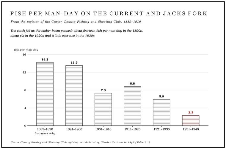
The register recorded catches for every year from 1889 to 1940Hall 1969, 204., and the club’s members wrote down more than fish. On May 24, 1907Stevens 1991, 152, quoting the Carter County club register., a party from Carthage put in on the Jacks Fork about three miles above Eminence with the river “about 18 inches high,” caught sixty bassStevens 1991, 152; Hall 1969, 204, prints what appears to be the same entry, undated, with sixty-nine bass and “River high.”, a Jack salmon. The Ozark name for the walleye, a fish not collected in the Jacks Fork since 1980 (Chapter 9; Chapter 16). Glossary → (the Ozark name for a walleyeHall 1969, 204.) and a shad, and “had a fine time and good ride with Andy Pitman (guide) in gasoline boat.” The same entry records the first locomotive crossing the river on the new logging railroad (Chapter 7). In 1946Callison 1946, as tabulated in Hall 1969, 204, and Stevens 1991, 155 (table 4). the register’s catches were worked out as fish per man-day, and the figures are the nearest thing to a fish count on the two rivers before modern sampling (Table 9.1). A man-day is one man fishing for one day, so a party of four on the water for a week fished twenty-eight man-days. At the rate of 1889–1890 such a party would have brought in about four hundred fish, and at the rate of the 1930s about sixty-fivearithmetic from Table 9.1 (twenty-eight man-days at 14.2 and at 2.3)..
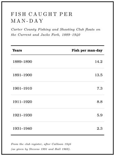
The catch fell as the timber boom passed. The cutting came first. Then the Cutover. Land from which the timber has been cut. The lumber companies left much of the Jacks Fork country cutover by about 1920 (Chapter 7). Glossary → hills were burned year after yearCallison 1946, as quoted in Hall 1969, 205 (“The hills were burned annually in a futile attempt to turn them into farmlands; over-grazing and the plow assisted in laying the land bare to erosion. Millions of tons of Ozark topsoil, and later the underlying gravel, swept down the hillsides and into the streams”). in the hope of turning them into farms, stock overgrazed them, and the plow helped lay the land bare. With the cover gone, rain carried the topsoil down the slopes and into the creeks, and after the soil the gravel beneath it. “The good old days were good, all right,” a conservation writer concluded in 1946Charles Callison, in the Missouri Conservationist., “but it didn’t take man long to spoil them.” The years from about 1920 to 1935 were probably a low point for the natural resourcesHall 1969, 104 (“a low point in the history of natural resources in the Current River country”). of the Current River country. In November 1936 Missouri’s voters passed Amendment No. 4, an initiative petition that the Conservation Federation of Missouri had carried, and wrote into the constitution a Conservation Commission of four members appointed by the governor and kept apart from party politics, to run the state’s fish, game and forestsMissouri Constitution, art. IV, sec. 40(a). on license moneyMissouri State Archives, RG 103, agency history (Amendment No. 4 passed by initiative petition in November 1936; the commission a four-person board appointed by the governor; the department “non-political,” funded by hunting, fishing and trapping licenses and, from 1976, a sales tax).. How the gravel changed the river is taken up in Chapter 15.
The upper Jacks Fork got a club of its own in 1912Stevens 1991, 151–52., when a Springfield group incorporated the Shannon County Hunting and Fishing Club. Its charter promised to bring together “gentlemen in commercial, manufacturing and professional pursuits throughout Southern Missouri.” The members built ten cabins on the river above Rymers, near Ebb and Flow SpringNPS, “Rymers Ranch History”; Stevens 1991, 151 (“built cabins on the Jacks Fork”).. In the early 1920s a Birch Tree dentist, H. Kirkendall, spoke for the club in letters to the governor proposing a state park along the Jacks Fork itself, as much as 45,000 to 60,000 acres, that would take in AlleyStevens 1991, 178.. The state chose the springStevens 1991, 179. instead, and the idea of a park that followed the river came back Forty. Forty acres, a quarter of a quarter section. A hill farm was often one or two forties (Chapter 5). Glossary → years later (Chapter 10). The club outlasted the other early clubs and still existed in the 1980s. Most of its cabins were standing in 1991Stevens 1991, 152 and n. 20.. One, photographed in 1990, burned the next yearStevens 1991, 154 (fig. 36)., and the rest have since fallen in or been taken downNPS, “Rymers Ranch History.”.
The bridge at Buck Hollow, in use by early 1915 (Chapter 8), opened the upper river to the same trade. In June 1915Wehmer 2024, quoting the Mountain View Standard, June 1915. the Mountain View Standard reported that six local men had floated from Buck Hollow down the Jacks Fork and the Current to Van Buren, “returning on the train.” They caught “all the fish they could eat and brought thirty pounds home. Pet Padgett landed the largest bass, a five-pounder, and Will Arthur got so excited he caught two good bass at one time.” Frank McGrath, “as usual, succeeded in getting overboard, but this time was generous enough to take boat and all over with him,” and the party fished out everything but “a fine diamond ring, a $5 pair of shoes, a tent fly, and a bundle of bedding,” all of them Joe Starkey’s. “Somebody thought to take a gallon of lubricating oil for Arthur’s reel, and consequently were able to hear themselves think.”
Camps on the upper river
The resort era on the upper river began at Buck Hollow. Charles Whitbeck had run a large hunting and fishing camp in the Adirondacks before he and his wife, Willie, came to the Ozarks. The camp’s opening is given as 1920, and in 1921 Willie A. WhitbeckNPS 2013, 24, 26. bought the land on the south bank just below the bridge. In the newspapers of the day the name was spelled Witbeck. By August 1922 the West Plains Semi-Weekly Quill called Camp Witbeck, “four and one-half miles north of Mountain ViewWehmer 2024, quoting the West Plains Semi-Weekly Quill, August 1922. on Jack’s Fork River,” “fast becoming one of the most popular playgrounds of the southern Ozarks,” with “many visitors from distant cities” and its cabins and tents “full throughout the season.” The Whitbecks advertised in the local papers and in Kansas City and St. LouisWehmer 2024..
The cabins stood in a single row about twenty feet apart on a narrow Terrace. A level bench above a river, the remains of an older floodplain left high when the river cut down (Chapter 2). Glossary → above the river, just above the Hundred-year flood. A flood with a 1 percent chance of being equaled or exceeded in any given year. A 500-year flood has a 0.2 percent chance. The names describe odds, and a 500-year flood can come twice in a decade (Chapter 14). Glossary → line, so that each one looked out on the water. A hundred-year flood is one with about one chance in a hundredthe definition of the hundred-year flood (general; see Chapter 14). of being reached or passed in any given year (Chapter 14). Stone steps led down to a grassy lower terrace on the bank, and across the river a Dolomite. Calcium magnesium carbonate rock, a close relative of limestone, formed from lime mud on the floor of a warm, shallow sea. Nearly every bluff on the Jacks Fork is dolomite (Chapter 1). Glossary → bluffNPS 2013, 59. rose from a swimming hole that gave the camp its jumping rockWehmer 2024.. At least seven cabinsNPS 2013, 7, 33, 35, 48. and their outbuildings went up in the 1920s and 1930s. In September 1929 the rural mail carriers of Howell, Texas and Wright counties held their annual picnic and business meeting there. The story goes that Mrs. Whitbeck once saw a Mountain View auctioneer arguing with her husband and, believing he meant him harm, shot the auctioneer, who sued the couple for ten thousand dollarsWehmer 2024, the only source found.. The camp ran through the Depression and closed only when Charles Whitbeck died in 1940, at seventy. He is buried in the Mountain View City CemeteryWehmer 2024..
In 1941 his widow sold the camp to the Beckman family, who renamed it Cardinal Acres. It passed to Dr. Charles R. Hawker and in 1948 to Jo Eickhoff and her cousin Joe SchmittWehmer 2024. by one local account … *Life … 1950*: Wehmer 2024, the only source found; the Park Service’s 2013 landscape inventory (NPS 2013) does not mention it. of Chicago. In 1950, by one local account, Cardinal Acres appeared in Life magazine, and business surged. Later the cabins were owned separately or rented months aheadWehmer 2024.. The last private owner, Vernon C. Campbell, ran a lime quarry nearby and owned several hundred acres around the bridge. Most of the cabins were razed between 1966 and 1969, and on October 15, 1969, Campbell sold 600 acres to the United States for $83,000. In 2013 two cabins and two privies still stood among stone foundations and retaining walls, with daffodils and irises from the resort years blooming in the second-growth woods, and the 5.4-acre site was the largest complex of cabins and cabin ruinsNPS 2013, 7, 22, 24, 26, 59, 63–65. the government owns anywhere in the Riverways (Reach D).
Mountain View had a second camp at Buck Hollow from 1929Wehmer 2024.. The year before, a group of the town’s business and professional men had bought land at Radcliff Ford to build a clubhouse and bungalowsWehmer 2024, quoting the Mountain View Standard, October 10, 1928. for an outing club (Chapter 8).
Downstream at the place still called Rymers, Marian Rymer of Birch Tree managed Rymer’s Rustic Ranch in the 1920s and 1930s. A study of the county’s place names made in 1939 credited the ranch to E. H. Rhymer and his daughterO’Brien 1939, Shannon County, “Rhymer’s Ranch” and “Jam-Up Hollow.”, and Marian may have been the daughter. By one account the ranch, a few cabins at first, was already a popular resort in the early 1900s and ran down after a second generationLewis 1980, PDF p. 30 (“Rymer’s Ranch was a popular resort in the early 1900’s”), the only source; see Reach E. of Rymers inherited it. Guests fished, took boats on the river, rode horseback and danced to music. The same study called it “a large farm modeled after the dude ranches of the West,” and one of its attractions was a narrow valley, Jam-Up Hollow, that “can only be reached by horseback.” Marian Rymer catered to a small circle of St. Louis friendsStevens 1991, 191., though she advertised to the public, and local people worked there. A man born in 1916 who logged timber in the upper basin, and his wife, both worked at the ranchJacobson and Primm 1994, 39 (table 6). in the 1930s. She is remembered on the river as the “lady who greeted us as we went to river.” By 1977 a Park Service folder put the Rymers access “at the site of an old resort.”
A short float below Rymers is the one camp of that era that still operates. In 1929 E. T. Behrens, a retired newspaper editor and cigar maker from Sedalia, came to Shannon County after his doctor gave him six months to live. He was sixty-three. He settled where a small settlement called Bunker Hill had stood, called the place “paradise,” and built a fishing camp of a few cabins. The 1938 state highway map showed “Bunker Hill Ranch”O’Brien 1939, Shannon County. as a tourist resort. Behrens lived eighteen more years, and in 1947, at eighty-one and failing, he deeded the camp to the Missouri State Teachers Association and died a month later. The association brought in electricity, improved the road and added cabins, a dining hall, a recreation hall, a one-room schoolhouse and a small chapel. For more than sixty years it was a members’ retreat, remembered along the river as “a teachers camp”Jacks Fork Oral History, record SV-05. or the “teacher cabins,” and a Park Service river folder of 1977 asked floaters to “respect the private property rightsNPS 1977, stop 7. of the Missouri State Teachers Association.” A Mountain View writer told in 1976 of friends staying at “Bunker Hill, a teacher’s resort on Jacks Fork,” who fished a mile or a mile and a half down the river at “a big hole of water by a big rock cliff” and brought back bass of three and a half and four poundsOzark Riverways 1976, PDF pp. 29–30 (Noval Cantrell’s column; the trip undated), the only source.. In 2013 the property passed to a nonprofit, Friends of Bunker Hill, which opened it to the public. It sits on 2,080 mostly undeveloped acres inside the park boundary, and in 2018 it still served family-style meals three times a dayOstmann 2018. (Reach F).
At the foot of the upper river, Alley Spring had been a gathering place since the 1890s. George McCaskill, who built the mill there in 1893–94, laid out a picnic groundPerry [1978], sec. 8, 2. by the millpond for boating, dancing and ball games, and people came from around the county for the Fourth of July. In 1912 a Kansas City company bought Alley meaning to promote it as a “pleasure resort,” and that August an estimated five hundred Odd Fellows came by chartered train to West Eminence and walked or rode the last four milesStevens 1991, 157, 161. to the picnic ground. The state bought the spring, mill and 427 acres in 1924Perry [1978], sec. 8; Stevens 1991, 179. for one of Missouri’s first state parks (Chapter 10). By 1927 it had a swimming beach and beach houseStevens 1991, 182. on the Spring branch. The stream that runs from a spring to the river, such as the branch below Alley Spring (Reach H). Glossary →. The Civilian Conservation Corps, the New Deal programgeneral. that put young men in camps to work on forests and parks, arrived in 1933, and in its later years as a state park Alley drew as many as a quarter of a millionPerry [1978], sec. 8, 2–3. visitors a year (Reach H). By the 1930s the foot of the upper river had a public park with a beach, a campground and a highway, and the canyon above it had a handful of private camps and almost no roads.
A poet in a twelve-foot boat
In early July of a drought summer, probably 1934Dorrance 1938, 1, 6, 25. The book gives no year; its datelines, “A Saturday, 9 June” on the Black River and “Mountain View, 7 July,” fit 1934 and fit 1928 as well, and the drought fits the 1930s better., two men arrived in Mountain View meaning to float the Jacks Fork. Ward Allison Dorrance, born in Jefferson City in 1904, taught at the University of MissouriWhitaker 2025.. His friend George, “six feet three,” is never given a surname. They had just come off the Black River. Dorrance’s book of the trip, Three Ozark Streams: Log of the Moccasin and the Wilma, appeared in 1937 and went into a second editionDorrance 1938, xi–xii. the next year. Its eleven pages on the Jacks Fork are the fullest early account of floating the river (Fig. 9.2).
He wrote it as an antidote. In his foreword he mocked the booster guidebooks of the day, with their lists of every spot “which you must avoidDorrance 1938, xiii.: the lodge with ‘Dancing Sat. Nite,’ the cavern lighted by electricity.” In Mountain View an old man offered to build them a boat if they would wait a week, but the proprietor of the meat market had one for sale, and they bought her. The Wilma was nothing like a johnboat. “She is twelve feet long, deep and wide, with inward-sloping sides. She has a keel.” A keel is a fin along the bottom that holds a boat to a straight course in open water, and on a shoaly river it sits lower than the rest of the hull, catches on the rocks and makes the boat slow to turngeneral.. She was painted white with black and yellow trim, and her builder had been born and raised on the MississippiDorrance 1938, 25..
Nobody could tell them whether the river could be floated. The answers were “baffling, no two alike,” and after the first day Dorrance wished they had listened to the old man who said only, “I hain’t a-sayin’. Mebbe ye kin . . .” In drought the upper river was, as the people along it said, “shoals and Pot-hole. A 1930s word for a still pool under a bluff, between shoals (Chapter 18). Glossary →, jest shoals and pot-holes.” A pot-hole was a still Pool. A deep, slow stretch of river between riffles (Chapter 16). Glossary → under a bluff, with Virginia creeper trailing down to a bed of cow lilies, and below it came a shoal that turned at right anglesDorrance 1938, 26. through jagged rock. Loaded with a fortnight’s suppliesDorrance 1938, 28–29., the boat could not be lightened, and they dragged her over stones that were “slippery being moist” and that “act as rollers, being round.” That evening they camped on a gravel bar. “There is no dirt hereDorrance 1938, 26. on the bar of the river,” Dorrance wrote. “There are no men.”
The book’s best-known lines come from those first days. “In spite of its awkward frontier nameDorrance 1938, 28., this is the poet’s river. . . . The river is personal, trusting, chatty. It romps but like a Mozart quintet . . .” Nearly eighty years later the state’s conservation magazine opened a float story by calling the upper Jacks Fork “the Mozart of rivers.” Below Blue Spring the water changed: “The Fork jumps outDorrance 1938, 29. like a trout stream now, deep and clear and indigo,” and “from here there are long, full-lipped ways between the shoals.” They passed the Hospital Cave sign, the spring’s blind fishDorrance 1938, 29. and a cave that blew cold airDorrance 1938, 31. from a hillside (Chapter 13), and climbed into a great cave Dorrance called “Jimjam,” which is Jam Up.
He liked the people he met, though he called them “natives” and spelled their speech by ear. A ridge family too embarrassed to name a price for a chicken, and short of changeDorrance 1938, 28., told him to pay the wife’s father down the river. Who, and where? “Aw, jest give it to the first feller ye meet with a peeled head!” A landowner who rode up “a-muleback”Dorrance 1938, 31. offered them the run of his thousand acres: “If anybuddy tries to run ye off, tell ’em yo’re boss here!” As the valley widened toward Alley the pools grew “wider, deeper, longer,” and they saw “women washing clothes in the river, men ‘grabblin’’ for a wounded bass in the rocks of the shore,” feeling for it with their handswhat grabbling is (general). under the ledges, and a granny driving geese down a lane.
At Alley they stood astonished at the spring and the mill, “an honest block,” with the spring stream thundering down its Chute. A narrow, fast slot of water through a shoal or past an obstacle. A smooth V of water pointing downstream marks the deepest path through it (Chapter 20). Glossary →. They camped a mile below and left “nowhere so much as a match,” and a morning or two later, not quite knowing where they were, they were swept out onto the Current, “a river so clean, so fullDorrance 1938, 35., so broad, so swift that it has forced four races to name it Current.” On the Current they found outing parties along the banks near Van Buren and a Concession. A business under contract with the Park Service to serve visitors inside the park, such as the canoe rentals at Alley Spring and Two Rivers. The canoe-rental permits became concessions in 1973 (Chapter 10; Chapter 11). Glossary → at Big SpringDorrance 1938, 41, 43–44.. The Jacks Fork above Alley had shown them almost nobody. At the end they trailered the Wilma back to Mountain View, their “point of departure,” and to the Commercial, an inn with a pepper-box tower under honeysuckle, for a supper of cold chicken and biscuits.
Dorrance exaggerated freely, and his Jam Up mouth is “two hundred feet high,” more than doubleDufur 2013, 21 (about eighty feet). its real size. He also saw the upper river in drought and before the crowds and wrote down what he saw: deep pools under bluffs in a dry year, rippled gravel bars between them, and solitude.
Guides from Eminence
The professional guide trade came to the Jacks Fork from Eminence. David Bales, who published a weekly paper in Eminence before he went to the state legislature, had fished the Current and the Jacks Fork since the early years of the century, and his son Walter opened a grocery and general storeHall 1969, 115–16. in town. In 1926Stevens 1991, 193, the only source. the elder Bales headed the advertising committee for the Outdoor Life Exposition in St. Louis, which Missouri business and sporting interests put on to promote the Ozarks for recreation, and where the Missouri Ozarks Chamber of Commerce showed a display on the “Big Springs Country.” In 1928 Walter Bales began guiding johnboat floats from the store. The business grew into the Bales Boating and Mercantile Company, with a dozen good fishing boats, a stock of tentsHall 1969, 117. and camp gear and a crew of young rivermen he trained as guides. His “deluxe Float trip. A trip down the river by boat, from a few hours to several days, with a way back arranged at the end (Chapter 20). Glossary →” were popular with city business leaders and their political alliesStevens 1991, 192 (“urban business leaders and their political allies”).. “We’ll start from our boat landingHall 1969, 117.,” Bales would tell his clerks, “and you have the truck meet us at the mouth of Mill Creek to haul the boats home.”
A floater who made his first trip with a Bales outfit in the late 1920sLeonard Hall, some thirty years before he wrote (Hall 1969, 118). remembered Bales as the only merchant he knew “into whose store you could walk at eight o’clock on any Thursday morning during the bass season and say ‘Let’s go fishing’ and know you wouldn’t be turned down.” In the early days the guides were told “to bring in the legal limits for their sportsmen by any means short of dynamiting the stream,” and if the fisherman was an amateur, the guide caught the fish for himHall 1969, 117 (“his guide caught the fish for him”).. In the 1930s Bales put away his bait-casting rods and took up fly fishing, and with a single hook he could let most of his catch go unharmed. A fly on a single hook usually catches a bass in the lip and comes out cleanly, where a plug hung with gangs of treble hooks can tear its mouth and gillsgeneral.. His guides came to believe that a fish left in the stream was worth as muchHall 1969, 118 (the guides learned “that a fish in the stream has a value equal to or greater than one in the livebox or on the stringer”). as one in the livebox or on the stringer, or more.
Other outfitters grew out of his. Garland Winterbottom, one of Bales’s top commissary guides, started his own float service in Eminence, and Walter MartinHall 1969, 117; Stevens 1991, 192., another Bales trainee, carried it on after Winterbottom died. A guided float ran as a small flotilla. The fishing boats carried the sportsmen and their guides, and the commissary boat carried the tents, the camp gear and the food, with a guide who made camp and cooked. By the late 1950s Eminence was the headquarters for fishermen and other visitors to the two rivers, and several outfitters there could equip a party of any size with fishing and commissary boatsHall 1969, 70–71 (Eminence “headquarters for fishermen and recreationists,” where outfitters could supply “fishing and commissary boats, guides who not only run the boats but make camp and cook, tents and other camp gear, and food”)., guides, tents and food. Walter Bales was later killed in a highway accident, and his widow and their daughter ShannonHall 1969, 119. kept the business going.
A Shannon County boy born in 1932 ran boats for the Bales company as a teenager, about 1949 or 1950, and remembered the work half a century later. A guide had to hold a state license. He was paid eight dollars a day and his room and board, or ten if he brought his own outboard, and room meant a tent and board meant meals cooked over a campfire. The old wooden johnboats were heavy and “made like a barge,” not built for outboard motors, and a guide who used a motor hung it on a block of wood fastened to the stern. One man built most of the Bales boats. The customers came from all over, and the boy’s first float was with the president of the International Shoe Company of St. Louisthe company’s home (general).. Between trips he drove fishermen’s cars around to the Put-in, take-out. The places where a float begins and ends (Chapter 20). Glossary →, and he kept at it part-time even after he came home from the Navy. The river he guided on, as he remembered it, carried more water and ran faster, down a stair-step of pools and chutesDix 1998, 4–6 (a published oral history; he named his first customer as Al Fair, the company’s president, and dated the work “’49 or ’50”), the only source. that have since flattened out (Chapter 15).
In 1931 Otto Ernest Rayburn, a former schoolteacher and Ozark booster who did as much as anyone to make Ozark folklore popularafter Vance Randolph’s remark that Rayburn “did more to arouse popular interest in Ozark folklore than all of the professors put together,” as the Society of Ozarkian Hillcrofters quotes it., wrote to a friend in Eminence who owned a garage. He had never been to that part of the Ozarks, but he came, and started a little magazine, The Arcadian, in connection with the Eminence newspaper. The Depression and his partner’s poor health ended it in 1932, after about a year, and Rayburn moved on to Galena and then to TexasMcConnell, “Rayburn” (he “hadn’t been to the area”; the Arcadian ended “after just about a year”); Society of Ozarkian Hillcrofters, “Our History” (“In 1931, he started another magazine, The Arcadian, from Eminence, Missouri”); Rayburn Papers, biographical note (teacher, newspaper publisher, bookseller and promoter of tourism; died 1960)..
The upper river in 1957
Leonard Hall, born at Seneca in 1899, wrote an outdoor column for the St. Louis Post-Dispatch from 1943 and in 1945 settled for good at Possum Trot Farm near Caledonia, in Washington Countygeneral.. In June 1957, after five years of drought and then a wet spring, he and his wife, VirginiaHall Papers, biographical sketch (born October 30, 1899, at Seneca; columnist for the St. Louis Post-Dispatch from 1943 and the St. Louis Globe-Democrat from 1959 to 1980; married Virginia Watson in 1941; settled at Possum Trot Farm in 1945)., whom he called Ginnie, put a seventeen-foot aluminum canoeHall 1969, 65–67. in at “the Forks, the. The North and South Prongs and their junction, where the Jacks Fork begins; also called the Prongs (Chapter 18). Glossary → of the creek,” the head of the Jacks Fork, where the gravel road from Buck Hollow reached the stream “at a little Low-water bridge, low-water crossing. A road crossing built low across a stream, a ford with a floor, often a concrete slab with culvert pipes beneath it, which water overtops in a rise (Chapter 8; Chapter 18). Glossary →.” The stream there was so small “that I could have easily jumped across” it. The Forks were “a full day’s run above the bridge at Buck Hollow on Highway 17, which is the normal starting point for float trips,” and Hall thought the chance to float that stretch came “no more than once in a dozen years or so.” “Just one road touches this part of Jacks Fork valley,” he wrote, “and the chances are you will spend the entire day without seeing so much as a native fisherman along the bank.”
The upper river’s season was short. The Jacks Fork above Alley is a small stream, fed by rain and by springs too smallsee Chapters 12 and 14. to hold it up for long, so it can be floated only in seasons of more than normal rainfallHall 1969, 65 (“Since Jacks Fork is so small, it is possible to float only during seasons of more than normal rainfall. Even then one must catch the stream as it is dropping after a rise”; “Toward the latter part of June, floating on Jacks Fork is generally at an end”)., and even then the floater has to catch it as it drops after a rise (Chapter 14). By late June floating there was generally over, and in some years the headwaters could not be run at all. When the water was up, though, Hall thought that “nothing else in Missouri can equal it as canoe water.” To him the upper Jacks Fork was the closest thing to Wilderness. Federal land designated by law to be kept without roads or development. About 4,000 acres around Jam Up Cave were studied for it in 1981 and judged unsuitable (Chapter 10). Glossary → in the Current River country, because the valley held almost no farmland and few roadsHall 1969, 64. had reached it. The bluffs and pools up there might well have names, he wrote, but “the names would be known only to the local people.”
At a chute that dropped about five feet in a quarter mile they let the canoe down on a rope, wading or walking the edge while the current carried the boat ahead of them, then ran the last of it, sighted “the high Buck Hollow bridge” at dusk and unloaded at Cardinal AcresHall 1969, 72, 76., “a pleasant cottage camp located just below Buck Hollow.” As they came ashore, two aluminum canoesHall 1969, 76–77. came around the bend, each paddled by a couple with a pair of children sitting on top of the duffel in life jackets. They had put in at Buck Hollow, had turned over once already, and were bound for Bunker Hill, a day’s float below. They made it, Hall heard later, “with two more spills but no damage to themselves.” The guided johnboat party was giving way to the family in a rented or borrowed canoe.
The aluminum years
After the Second World War, and especially in the 1960s and 1970s, the Ozark float trip changed from a sport for the well-off in nearly wild country into a cheap family outing. Better roads and cars opened nearly every floatable stream (Chapter 8). Fiberglass and then aluminum boats and canoes replaced the heavy wooden johnboat. An aluminum canoe was light enough for two people to liftgeneral. onto a car, and a scrape on a shoal left only a dent. Two books helped spread the word: Hall’s Stars Upstream (1958Brown 1969, 37 n. 12; Hall 1969, title page.) and Oscar Hawksley’s Missouri Ozark Waterways, a guide to thirty-seven float streams that the state Conservation Commission published in 1965 and revised in 1972. The revised edition sold for a dollar. It called the Jacks Fork “one of the wildest and most scenic of the Missouri Ozark streams,” its valley “nearly a canyon, with no bottomland fields for the first 25 floatable miles,” and told floaters with loaded canoes to try the river above Alley only in spring or after good summer rainsHawksley 1965, cover, title page, 98 (the revised edition of 1972, the copy held; the 1965 wording cannot be told apart from it).. Canoe-rental businesses sprang up to serve floaters from Kansas City, St. Louis, Springfield, Tulsa, Little Rock and Memphis, and it became common to see vans pull up at a Put-in, take-out. The places where a float begins and ends (Chapter 20). Glossary → towing trailers stacked with a dozen canoes. Guides were seldom hired any more, and a newcomer who brought one would have felt out of placeRafferty 1985, 42 (the float trip changed “from a semiwilderness sport for the more fortunate to a relatively low-cost family sporting activity”).. In 1963 a party on the upper Current rented seventeen-foot aluminum canoes from a tavern keeper between Salem and Eminence for five dollars a day“Not So Gently Down the Stream,” 1963.. Some of the early renters pulled root wads and drift out of the channel to save their canoes, by the account of a former johnboat guide, who wondered laterDix 1998, 6, the only source. whether that had helped change the river. In 1976 the Eminence calendar listed a Jacks Fork canoe race on May 15Ozark Riverways 1976, PDF pp. 21–24..
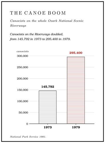
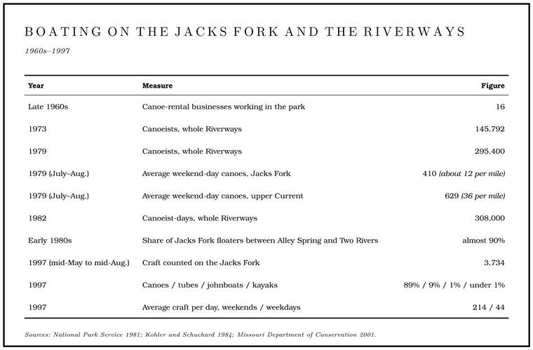
The national park arrived in the middle of the boom and sped it up. In the park’s early years canoeist-days grew by more than 40 percent a year, and in the late 1960s sixteen canoe-rental businesses worked in the park under special permits. A canoeist-day is one person on the river for one daygeneral., so a couple on a two-day float counts four. Canoeists on the Riverways numbered 145,792 in 1973 and 295,400NPS 1981, 18. in 1979, most of them in rented canoes, and in 1982 they put in 308,000Kohler and Schuchard 1984, 114. canoeist-days. The question of who could rent canoes on a federal river led to years of argument and lawsuitsRagsdale 2017, 46–48. between the Park Service and the canoe renters (Chapter 10). The superintendent who came to the park in 1976 remembered that the trouble began with a little under 1,800 commercial canoes, that at one time more than 3,000 were working the rivers, and that after ten years of litigation the number permitted settled at about 2,400Sullivan 1998, 21 (“a little under 1,800 commercial canoes”; “At one time there were more than 3,000 operating”; “I think we ended up with something like 2,400 permitted canoes”); his years at the park, Sullivan 1998, 6–7.. In 1981 a canoe concession, restaurant, store and motel called Harvey’s was operating at Alley Spring under a Term estate. A right of private use that ran for a fixed term after the government bought the land, as Harvey’s at Alley held (Chapter 11). Glossary →NPS 1981, 81–82., a right of private use that ran for a fixed term after the government bought the land.
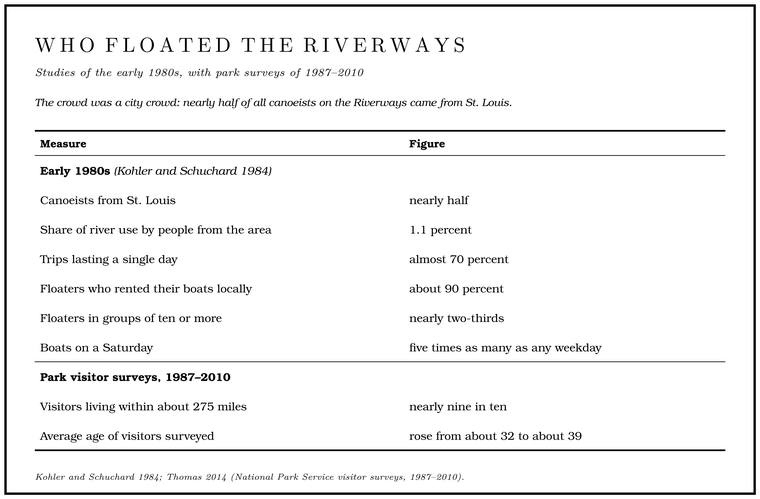
The crowd was a city crowd. In the early 1980s nearly half of all canoeists on the Riverways came from St. Louis, and people from the area accounted for only 1.1 percent of river use. Twenty years before, as a writer on the two rivers put it in 1984Steve Kohler (Kohler and Schuchard 1984)., “almost every boat contained at least one Ozark riverman as a guide.” Almost 70 percent of trips lasted a single day, about 90 percent of floaters rented their boats locally, nearly two-thirds traveled in groups of ten or more, and Saturday brought five timesKohler and Schuchard 1984, 114 (Kohler’s text, after studies of the early 1980s). as many boats as any weekday. On some summer weekendsKohler and Schuchard 1984, viii., the same writer found, a visitor looking for wilderness “may well wonder if he hasn’t found a canoe parking lot rather than a free-flowing stream.” A Park Service river folder of 1977 advised floaters that the rental agencies would Shuttle. The trip that brings vehicles from the put-in to the take-out, so floaters can get back (Chapter 20). Glossary →NPS 1977. them and their canoes, and it warned anyone running the upper river to be “prepared to sacrifice some aluminum from your canoe to the underlying rocks.”
People who had grown up on the upper river measured the change partly by the boats. A woman who had played along the river as a child in the 1920s and 1930s remembered in the early 1990s, “You see there was no canoe floatingJacobson and Primm 1994, 58., just the john boats. I’ve seen the canoes coming down and even the canoes can’t float over the rapids; they have to get out and guide them along.” A longtime resident said the fish were far fewerJacobson and Primm 1994, 61. “because we got so many people anymore.” A Current River trapper and former fishing guide said in 1998 that there were “a lot of otters over here on Jacks Fork,” and that many people said there wasn’t “near the fish on Jacks Fork as there was,” though he blamed the crowds on the riverSteen 1998, 11. more than the otters.
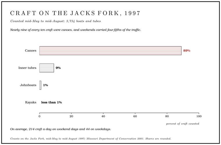
By the late 1990s the canoe owned the river. Between mid-May and mid-August 1997 counters on the Jacks Fork tallied 3,734MDC 2001, PDF 86, 153, after a 1998 Southern Illinois University river-use study. boats and tubes. About 89 percent were canoes, 9 percent inner tubes, 1 percent johnboats, and kayaks less than 1 percent. Weekends carried four-fifths of the traffic, an average of 214 craft a day against 44 on weekdays (Table 9.2). The crowd was a regional one. Visitors to the park were questioned at intervals from 1987 to 2010Thomas 2014, 11, 16–17, 22–25, 39–46 (the 2010 mean age may be pooled across districts), who credits the low cost of a trip and the “pervasive local availability of rental float crafts.”, in 2010 in the Jacks Fork district at Alley Spring, Two Rivers and Powder Mill, and across the park nearly nine in ten lived within about 275 miles. Most were casual visitors who came about once a year, probably because a trip cost little and rental boats were to be had all around the park. Over those two decades the same crowd grew older, and the average age of the visitors questioned rose from about 32 to about 39.
Two rivers in one
The Jacks Fork took its share of the traffic, and it took it almost entirely below Alley. In July and August 1979 the river carried an average of 410 canoes on a weekend day, about twelve to the mile, against thirty-sixNPS 1981, 29 (table 3). to the mile on the upper Current. In the early 1980s almost 90 percent of the floaters on the Jacks Fork were on the fourteen milesKohler and Schuchard 1984, 114 (their distance is fifteen miles); measured along the river centerline, Alley Spring to Two Rivers is 14.2 miles. between Alley Spring and Two Rivers. In 1981 the Jacks Fork and the lower Current were still wilder and less developed than the upper CurrentNPS 1981, 29 (the upper Current “offers high density canoeing, with faster water, more services”; the Jacks Fork and lower Current “are of a more primitive natural character, with less frequent development”)., and the upper Jacks Fork drew floaters mainly in the spring high waterNPS 1981, 60. and in summer was often too lowNPS 1981, 6. for canoes at all. The canoe-use zones drawn in 1985 split the river at Alley: Zone 9 from the Prongs to Alley Spring and Zone 10 from Alley to Two Rivers, reckoned at 24.5 and 14.9MDC 2001, PDF 86. miles; measured along the channel they are about 32 and 14measured along the river centerline traced for the maps in this book (the junction of the prongs to the Highway 106 bridge, 32.03; the bridge to the mouth, 14.18).. In 2010 the park’s interviewers stood at Alley Spring, Two Rivers and Powder MillThomas 2014, 11 (table 2)., and none at Buck Hollow, Blue Spring, Rymers or Bay Creek.
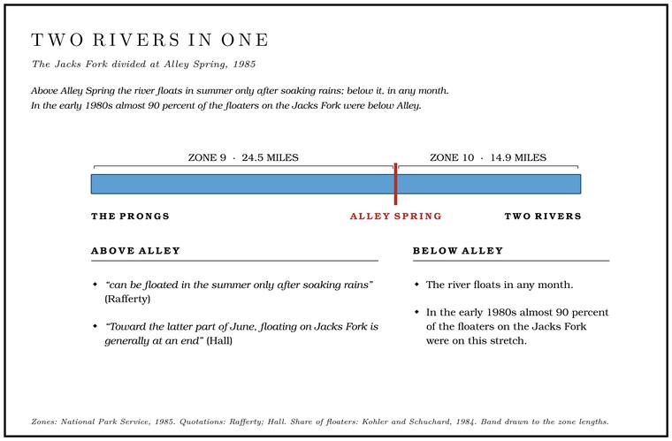
The division rests on water. Above Alley the Jacks Fork is a rain river (Chapters 12 and 14). Dorrance dragged a loaded skiff over its shoals in the mid-1930s, Hall found its season over by late June in 1957, and through the 1980s the Section. A square mile of 640 acres, one thirty-sixth of a township. A quarter section is 160 acres (Chapter 5). Glossary → above Alley Spring could be floated in summer only after soaking rains, though in the low-water months it kept many pools where people could fish and swim in privacyRafferty 1985, 68 (“can be floated in the summer only after soaking rains”; “many pools in that stretch of the river where fishing and swimming may be enjoyed in privacy during the low-water period”).. Alley Spring changes that. In a dry August the spring can nearly triple the riverMugel, Richards and Schumacher 2009, 28 (table 2); see Chapter 12. (Chapter 12), and below it the river floats in any month. Roads widened the gap. Below Alley, Highway 106 and the town of Eminence sit beside the river, and a rented canoe can be put in and picked up within a few hours. Above Alley, the canyon from Highway 17 to Bay Creek has few roads and long gaps between public accesses.
History widened it further. The lower river’s trade grew out of the Eminence guides, the state park at Alley and the canoe liveries, all built to serve visitors. The upper river’s camps were few and small, and most belonged to people from the region: Mountain View businessmen at Radcliff Ford, a Birch Tree woman at Rymers, Springfield men at the club cabins, a Sedaliasources under “Camps on the upper river” above. editor and then the state’s teachers at Bunker Hill. The swimming hole at the Highway 17 bridge is remembered mostly by people who grew up nearbyJacks Fork Oral History, records SV-06, SV-20. (Chapter 19).
The upper river still floats differently. A volunteer stream team, the Upper Jacks Fork River Rats, monitors its water and has hauled tons of trash out of the canyon, and the state manages its smallmouth bass under special rules (Part Six). On a spring float from Buck Hollow to Bay Creek, written up in the state’s conservation magazine in April 2013the article does not date the float; it was a spring trip made before the April 2013 issue, probably in 2012., the usual sights of a float trip were missing: overpasses, roads, power lines, crowded gravel-bar camps and the drone of outboard motorsDufur 2013, 20–23 (“overpasses, roads, power lines, countless gravel bar camps, and the drone from outboard motors”).. Dorrance had found the same water empty in the mid-1930s. The people who came for the river in the century since have changed it, through their fishing, their cabins and their numbers, and in the end by persuading the nation to protect it. How that protection was won, and what it cost the people who lived along the river, is the subject of Chapter 10.
| Date | Event |
|---|---|
| 1888 | Carter County Fishing and Shooting Club founded by Kansas City, Fort Scott and Memphis officials |
| 1888 | Current River Railroad completed through Mountain View, Birch Tree and Winona to Grandin |
| 1890s | McCaskill’s picnic ground at Alley Draw. A valley, in the usage of the Eleven Point side of the divide in Howell County (Chapter 18). Glossary → crowds for boating, dancing and ball games |
| 1907 | Carthage party floats from above Eminence with a guide in a gasoline boat |
| 1912 | Shannon County Hunting and Fishing Club incorporated; Odd Fellows’ excursion to Alley |
| by 1914 | Buck Hollow bridge (Highway 17) completed |
| 1915 | Mountain View party floats from Buck Hollow to Van Buren and returns by train |
| 1920–21 | Camp Witbeck opens at Buck Hollow |
| 1922–24 | Kirkendall proposes a park along the Jacks Fork; the state buys Alley Spring instead (1924) |
| 1928 | Walter Bales begins guiding from Eminence; Mountain View men’s club buys land at Radcliff Ford (camp working by 1929) |
| 1920s–30s | Rymer’s Rustic Ranch operates at Rymers (by one account a resort from the early 1900s) |
| 1929 | E. T. Behrens builds his fishing camp at Bunker Hill |
| 1931–32 | Otto Ernest Rayburn publishes The Arcadian at Eminence |
| 1933 | Civilian Conservation Corps. The New Deal program that put young men in camps to work on forests and parks. Its camp at Alley, set up in 1933, rebuilt the mill dam and built much of the old state park (Chapter 9; Reach H). Glossary → at Alley Spring |
| Probably 1934 | Ward Dorrance floats from Mountain View to the Current |
| 1935 | Marguerite and Robert Lyon buy their farm near Mountain View |
| 1936 | Missouri voters create the Conservation Commission (November) |
| 1937 | Three Ozark Streams published |
| 1941 | Camp Witbeck sold and renamed Cardinal Acres |
| 1947 | Bunker Hill deeded to the Missouri State Teachers Association |
| About 1949–50 | A Shannon County teenager guides for the Bales Boating Company at $8 a day |
| 1950 | Cardinal Acres featured in Life magazine, by one local account |
| 1957 | Leonard Hall floats from the Forks; families in aluminum canoes bound for Bunker Hill |
| 1958 | Stars Upstream published |
| 1964 | Ozark National Scenic Riverways created |
| 1965 | Missouri Ozark Waterways published by the Conservation Commission |
| 1969 | Cardinal Acres land sold to the United States |
| 1973–1979 | Canoeists on the Riverways double, from 145,792 to 295,400 |
| 1985 | Canoe-use zones split the Jacks Fork at Alley Spring |
| 1997 | Canoes make up 89 percent of craft on the Jacks Fork |
| 2013 | Bunker Hill passes to Friends of Bunker Hill and opens to the public |