Mountain View sits on sandstone. The flat brown slabs that weather out of the fields around town belong to the RoubidouxWeary and others 2014, GIS data (bedrock at Mountain View), and 16 (Roubidoux sandstone weathering light brown to reddish brown; tabular float). Formation, a layer of sand, lime and Chert. A hard, fine-grained form of silica that forms in nodules and beds inside dolomite and stays behind when the dolomite dissolves. Most Ozark people call it flint. It makes up the river’s gravel and was the stone of the first people’s tools (Chapter 1; Chapter 3). Glossary → laid down along a tropical shoreline more than 470 million years agoThornberry-Ehrlich 2016, PDF 102 (Roubidoux, 485–470 million years).. About five miles north-northwest of town the two Prong. A branch or arm of a creek, set down in 1860 as Southern usage. The North and South Prongs join to form the Jacks Fork (Chapter 18). Glossary → of the Jacks Fork come together, and the river begins its run to the Current River in the same rock. Within about a mileWeary and others 2013, GIS data; Weary and others 2014, GIS data, laid against the river centerline. it has cut down through the Bottom. The flat land along a river or creek, built of its deposits and open to its floods. In the 1920s the bottoms near Eminence averaged about a quarter of a mile wide (Chapter 2; Chapter 5). Glossary → of the Roubidoux into the gray Dolomite. Calcium magnesium carbonate rock, a close relative of limestone, formed from lime mud on the floor of a warm, shallow sea. Nearly every bluff on the Jacks Fork is dolomite (Chapter 1). Glossary → beneath. Forty-six milesriver centerline traced from USGS terrain and hydrography (Heimann and others 2025; USGS NHD). later, at its mouth, it flows past Knob. The old Missouri name for a hill of hard volcanic rock, such as those near Eminence and the mouth (Chapter 1). Glossary → of volcanic rock that are about a billion years olderWeary and others 2014, 4, 19. than anything in the Bluff. A cliff along the river, usually on the outside of a bend, where the river has cut sideways into the hill. In this sense the word was first used in North America (Chapter 2; Chapter 18). Glossary → upstream.
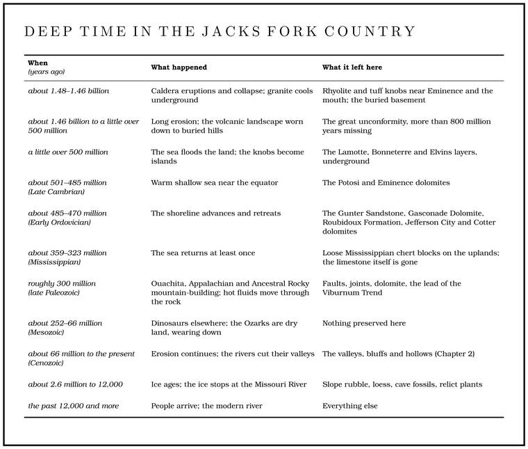
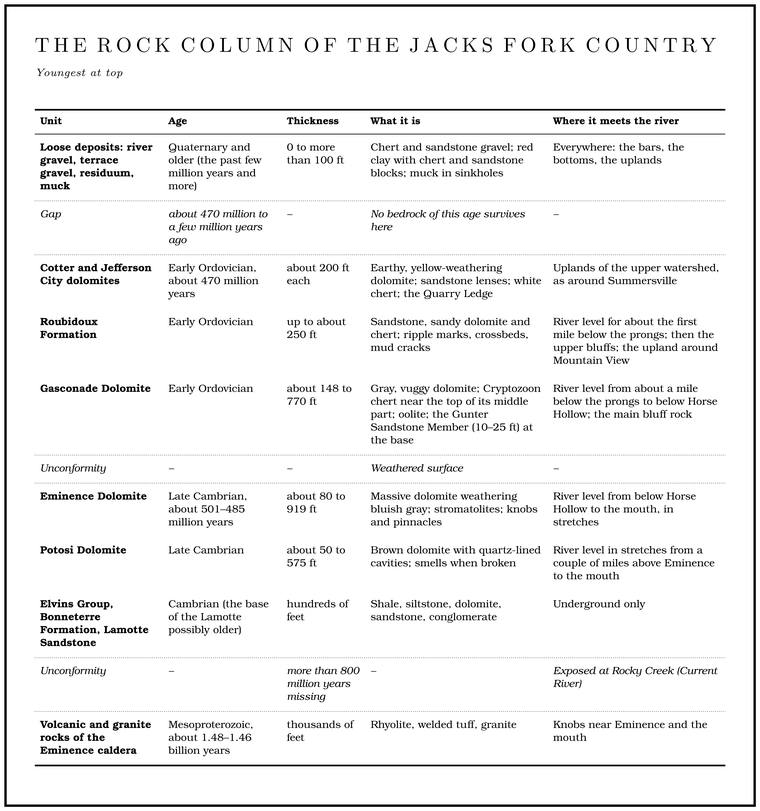
The river runs downhill faster than the rock layers do. The layers lie almost flat, while the river drops about 7 feet a mile on averagethe river profile measured on the 2021–23 riverbed survey (Heimann, Atkinson and High 2025; Map 12), about 330 feet in 46 miles; see Chapter 2. The 9.5 feet a mile often quoted for the Jacks Fork is the basin slope used in flood estimates (Wilson 2001, 2; see Chapter 14). (Chapter 2), so each mile downstream puts the water a little lower in the stack and among a little older rock. A float from the prongs to the mouth passes down through the rock record of the Jacks Fork country, from the Roubidoux to the Potosi Dolomite, with the volcanic basement rising beside the river at the end. Read from the bottom up, the record holds a volcano, a long gap, a warm sea, a shoreline, and then another long stretch of time that left almost nothing behind but chert.
Three clocks
The age of the rock and the age of the river are separate questions, and so is a third, the age of the channel a floater knows.
The first clock is the rock itself. The bluffs, ledges and boulders along the river are sedimentary rock from the Cambrian and Ordovician periods, roughly 500 to 470 million years old. Beneath them lies a basement of volcanic rock and Granite. A coarse-grained rock made of magma that cooled slowly underground. Granite near Big Spring has been dated at about 1.46 billion years (Chapter 1). Glossary → close to a billion years older still. Up to 1,800 feetThornberry-Ehrlich 2016, 3. of the younger sedimentary rock has been mapped in and around the national riverways, a pile about five times the height of the tallest bluff1,800 feet against the 350-foot face across from Grandma Rocks; see Chapter 2. on the river.
The second clock is the landscape: the high, rolling plateau, the steep hollows and the deep, winding valley cut into it. That clock started much later, once rivers began cutting down into the plateau, and it is still running (Chapter 2).
The third clock is the channel, the particular bends, Hole. Any pool deep enough to swim or fish in, named or not, the basic unit of the river in local speech; also “hole of water” (Chapter 18). Glossary → and Gravel bar. A bank of chert gravel and sand, usually on the inside of a bend, bare at low water (Chapter 15; Chapter 18). Glossary → of any given summer. It is measured in years and decades. Some of the low Floodplain. The flat valley floor that a river builds and floods (Chapter 2). Glossary → surfaces along the river are only a few decades oldThornberry-Ehrlich 2016, 12., and the holes and bars move with every big flood (Chapter 15).
A Jacks Fork bluff is a cliff of very old rock that the river has exposed only recently, as geologists count time. Nobody has put a date on the river as a river, and the rock in its bluffs was already hundreds of millions of years old when the valley began to form.
Reading the age of a rock
Geologists put ages on rock in several ways, and each method checks the others.
The oldest method is order. Sediment settles in layers, each on top of the last, so unless something has overturned the pile, the lowest layer is the oldest. Geologists call this superposition. A layer that contains broken pieces of some other rock is younger than that other rock. A crack that cuts across several layers is younger than all of them. Rules this plain give the sequence of events without a single number.
Fossils narrow the sequence. Living things change over time, and some changed quickly enough that a particular species marks a thin slice of time wherever it turns up. The most useful fossils in the Ozark dolomites are Conodont. A tiny, tooth-like fossil of an eel-shaped sea animal. Conodont species changed fast, which makes them the most useful fossils for dating the Ozark dolomites (Chapter 1). Glossary →, tiny tooth-like parts of an eel-shaped sea animal, most of them smaller than a grain of rice. They are abundant and they evolved fast. They are also made of calcium phosphate, the mineral of teeth and bone, so a block of dolomite can be dissolved away in weak acidgeneral explanation of relative dating and of how conodonts are recovered from carbonate rock. in the laboratory and the conodonts picked out of what is left. Conodonts are how geologists pinned down the age of the RoubidouxRepetski, Loch and Ethington 1998, as cited in Weary and others 2013, metadata. Formation in and near the national riverways.
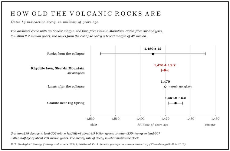
Numbers in years come from radioactive decay. Some kinds of atoms are unstable and break down into other kinds at a steady rate that heat, pressure and the passing seasons do not change. The rate is given as a half-life, the time it takes half of any amount to change. After one half-life half of the original atoms are left, after two a quarter, after three an eighth, so the share still unchanged works as a clock. Uranium-238 decays to lead-206 with a half-life of about 4.5 billion years. Uranium-235 decays to lead-207 with a half-life of about 704 million. When a volcanic rock cools, small crystals of the mineral zircon take in uranium and shut out lead, so any lead found inside a zircon crystal later was made there by decay, and the ratio of lead to uranium gives the time since the crystal formed. Each zircon carries both kinds of uranium, so it holds two clocksUSGS, Geologic Time; the two uranium decay chains as a cross-check are general knowledge of uranium-lead dating. running at different speeds, and a date is trusted when the two agree. The answers come with an honest margin. A Rhyolite. A volcanic rock at least 72 percent silica, the rock of the knobs near Eminence and the mouth. Much of the rhyolite here is tuff (Chapter 1). Glossary → lava from Shut-In Mountain, near Rocky FallsThornberry-Ehrlich 2016, 27, 32. southeast of Eminence, has been dated at 1,470.4 million years, plus or minus 2.7 million, from six separate analysesWeary and others 2014, 19. of its crystals. The margin is less than a fifth of one percent2.7 ÷ 1,470.4. of the age.
The dolomites of the bluffs cannot be dated that way. They formed from sediment on a sea floor, and their minerals did not start a clock when they formed. Their ages come from their fossils and from their position between rocks that can be datedUSGS, Geologic Time; Thornberry-Ehrlich 2016, 32.. A dolomite that lies on top of a dated lava is younger than the lava. At Rocky Falls the beds of Eminence Dolomite rest against the rhyolite of Shut-In MountainThornberry-Ehrlich 2016, 27 (fig. 20), 32., so they must be younger than its 1.47 billion years, and the fossils in them narrow their age to the Late CambrianWeary and others 2014, 17., about a billion years later. The mountain’s name carries an old Ozark word. Where a stream running in soft dolomite meets a ridge of the hard volcanic rock, it squeezes through a narrow, rocky gorge, and people in the hills have long called such a place a Shut-in. A narrow, rocky gorge where a stream cuts through hard rock (Chapter 2). Glossary →Sauer 1920, 11 (“These places, at which streams cross igneous barriers, are called ‘shut-ins’”). That Shut-In Mountain carries the word is the plain reading of its name; no record of the naming has been found. (Chapter 2). Rocky Creek drops over the rhyolite at the fallsThornberry-Ehrlich 2016, 27 (fig. 20, Rocky Falls “over rhyolite of Shut-In Mountain”)..
Conodonts also record heat. As they are buried and warmed over millions of years they darken, slowly and for good, from pale amber toward brown and black, and geologists Grade. The slope at which a river carries its load without cutting down or building up (Chapter 2). Glossary → the change on a color scale. The conodonts in the Lower Ordovician rocks of the southern Missouri Ozarks score only 1 to 1.5 on that scale, the pale end, which means the rocks were never heated past somewhere between 50 and 90 degrees Celsius, about 120 to 190 degrees Fahrenheitconverted.. Heat in the earth rises steadily with depth, so a low top temperature means shallow burial. The rock that once lay on top of these layers can never have been more than about 5,000 to 9,000 feetWeary and others 2014, 6; Thornberry-Ehrlich 2016, 58. thick.
The mappers
Most of what is known about the rock under the Jacks Fork was learned by people walking the hollows with a hammer and a map, and many of the names they chose came from somewhere else in Missouri.
The Roubidoux Formation and the Gasconade Dolomite were named in 1892 by the geologist Frank Nason, for Roubidoux Creek in Texas and Pulaski counties and for the Gasconade RiverUSGS Geolex, “Roubidoux” and “Gasconade.” in central Missouri, where the layers are well exposed. The Jefferson City Dolomite takes its name from bluffs along the Missouri River near the capital, and the Potosi Dolomite from the old lead town of Potosi in Washington County, both from work published by Arthur Winslow in 1894USGS Geolex, “Jefferson City” and “Potosi.”. The Gunter Sandstone takes its name from Gunter Spring, now Ha Ha Tonka Spring in Camden County, and from an abandoned post office in Miller CountyUSGS Geolex, “Gunter.”. Of the formations along the river, only one was named for a place on it. In 1911 the geologist Edward Ulrich named the Eminence Dolomite for exposures at EminenceUSGS Geolex, “Eminence.”, Shannon County. The town had been named for its high groundThornberry-Ehrlich 2016, 3., and the rock under that high ground was then named for the town.
The same paper of 1911 reached much further. In it Ulrich proposed a whole new system of geologic time, the Ozarkian, carved out of the upper Cambrian and the lower Ordovician, the span of the rock along most of the Jacks Forksee “Down through the rock” below., and named for the Ozark uplift, where, with the valley of the Appalachians, he counted some 8,000 feet of Limestone. Calcium carbonate rock formed from lime mud and shells on a sea floor. Most of the limestone laid down here later became dolomite (Chapter 1). Glossary → that belonged to it. He thought the Ozarkian, with the Canadian system proposed beside it, the crowning work of his career. Other geologists never took to the Ozarkian, and its rocks were handed backRuedemann 1946 (on Ulrich’s Revision of the Paleozoic Systems, Geological Society of America Bulletin 22, 1911: the Ozarkian and Canadian “the crowning achievement of his career”; the 8,000 feet “of limestone in the Ozark uplift and the Appalachian Valley” from R. S. Bassler’s account printed there; the growing “tendency to recognize the Canadian as valid and to abandon the Ozarkian”). to the Cambrian and to the Canadian, a name some American age lists still useUSGS Geolex, “Eminence” (ages given as Late Cambrian and as Canadian). for the Early Ordovician.
Few geologists had walked the Jacks Fork country before the 1920s. The men of the state’s first geological surveys, George C. Swallow, Benjamin F. Shumard and Garland C. Broadhead, never mentioned Shannon County in their reports and do not seem to have visited it. Those who did come were after copper (Chapter 5). One saw the Slater mine on Shawnee Creek in 1841, after its first working had stopped, and published a short account of it the next year. In 1875–76 C. P. Williams, head of the new school of mines at Rolla and state geologist by virtue of that post, visited the same mine, mapped its workings, drew maps of Round and Alley springs, and put the Porphyry. The old Missouri name for rhyolite, from the scattered crystals in its fine-grained body (Chapter 1). Glossary → in the Archean, the name then used for the oldest rocks of all. A short federal notice of Missouri’s copper deposits followed in 1905, written by Ulrich and H. Foster Bain, and in 1920–21 two investigators spent a few weeks in the region and wrote a report on the copper that was never publishedBridge 1930, 15–16 (the three “make no mention of Shannon Co.” and the area “does not appear to have been visited by these early workers”; Hodge describes the Slater mine “as it appeared shortly after the original mining operations had been discontinued”; Williams “First Director of the Missouri School of Mines and Metallurgy, and ex officio, State Geologist of Missouri,” his report in the Industrial Report for 1875–76, published 1877, with “a map of the surface workings of the Slater Mine, and also maps of Round and Alley Springs”; Williams “assigned the igneous rocks to the Archean”; the 1920–21 copper report by Bowles and Davidson, an unpublished thesis at the Missouri School of Mines). The 1841 visitor is Hodge (see Chapter 5). The given names of Swallow, Shumard, Broadhead and Bain are general knowledge; the name then used for the oldest rocks: general..
Between 1922 and 1928 Josiah Bridge, an Ohio-born paleontologist then in his thirtiescomputed from 1890., mapped the Eminence and Cardareva quadrangles, which take in Eminence and part of the Current River country, at a scale of about a mile to the inch. The work began with copper. The old mines near Eminence had been reopened during the First World War, and the survey was undertaken largely to meet the demand for better knowledge of the deposits. It grew into a study of the whole rock column. In 1923Bridge 1930, 15–17. Bridge’s field assistant, E. T. Campbell, traced most of the contact between the Gasconade and the Roubidoux across the western and southern parts of the Eminence quadrangle, the Jacks Fork side of the map. A contact, in a geologist’s sense, is the line where one formation meets the next, and on a map it is the line between two colors. Bridge’s report, published by the Missouri Bureau of Geology and MinesBridge 1930, title page. in 1930Weary and others 2014, 2, 21., gave names to layers that later geologists renamed or folded into other units. Part of what is now the middle Gasconade Dolomite was his Van Buren FormationWeary and others 2014, 16.. The year the report came out, Bridge moved to Washington as a paleontologist for the U.S. Geological Survey, and he worked there until his death in 1953Find a Grave, memorial 74999934 (a transcribed funeral notice: born at Norwood, Ohio; degrees from Cincinnati, 1916, Chicago, 1918, and Princeton, 1929; moved to Washington in 1930; a paleontologist with the Geological Survey for over twenty years; died at 62); BnF, “Josiah Bridge” (1890–1953)..
In the 1920s the porphyry outcrops of the region were read as a block raised by faulting. With a single exception near Van Buren, they fall inside a rectangle about fourteen by eighteen miles, its sides running northeast and northwest, and edges that straight and parallel suggested Fault. A break in the rock along which one side has moved. The faults that mark the Eminence caldera run northeast and northwest (Chapter 1). Glossary →, perhaps as old as PrecambrianBridge 1930, 135–36. time. The volcanic rocks near the mouth were recognized as the remains of a collapsed volcano in the late 1970s, when the Missouri geologists Geza and Eva Kisvarsanyi described the Eminence Caldera. The basin left when an eruption empties the magma chamber beneath a volcano and the ground above it collapses. The Eminence caldera, about a billion and a half years old, lies around the meeting of the Jacks Fork and the Current (Chapter 1). Glossary →, in papers of 1977 and 1984Weary and others 2014, 4, 23.. The faults that now mark the caldera run northeast and northwestThornberry-Ehrlich 2016, 32., the same directions as the sides of the old rectangle. The two had escaped from Hungary together in December 1956, after Soviet troops crushed the revolutiongeneral history. there, and reached the United States in January 1957. Eva Kisvarsanyi took her geology degrees at the University of Missouri and spent thirty-four years with the Missouri Geological Survey, from 1959 to 1993, retiring as its assistant director with more than a hundred papers, maps and booksKisvarsányi n.d., her own account (leaving Hungary with her husband, Géza Kisvarsányi, on December 1, 1956; arrival January 16, 1957; B.S. 1958 and M.S. 1960, University of Missouri; research geologist to section chief to assistant director). on the state’s Precambrian rocks to her name.
Detailed modern mapping came later still. From the 1990s into the 2010s the U.S. Geological Survey, with support from the National Park Service, mapped the riverways quadrangle by quadrangle at a scale of about 2½ inches to the mile. Each of these quadrangles is a block of country about eight and a half miles from north to south and seventhe size of a 7.5-minute quadrangle at this latitude, computed. from east to west. Eminence was mapped in 1999 and Alley Spring in 2012. The Jam Up Cave and Pine Crest quadrangles of the upper river were mapped in the field in 2005 and 2006 as part of a study of the Karst. Country shaped by dissolving rock, with caves, springs, sinkholes and losing streams. About 99 percent of the national riverways is karst (Chapter 1; Chapter 12). Glossary →Weary and others 2013, metadata., and the maps came out in 2013Weary and others 2014, 2 (table 1).. The geologists traced contacts on foot and fixed them by GPS, logged drill holes and well records, and drove most of the roads in the region looking at outcrops and at the loose rock lying on the ground, which geologists call float. In 2014 almost fifteen yearsWeary and others 2014, 3. of that work came together in a single geologic map of the upper Current and Eleven Point basins, and in 2016 the Park Service published a geologic inventory of the riverways built on it.
Outcrops are scarce in this country. Soil, red clay and chert rubble cover more than 95 percentWeary and others 2014, 7. of the ground in the Current and Eleven Point basins, and most of it is forested. Where the bedrock does not show, the float tells what lies beneath, because chert and sandstone survive the weathering that dissolves the dolomite around them, and the pieces lying on a slope come from the bed under them or from beds just uphill. On the uplands of the upper Jacks Fork no outcrop of the Jefferson City Dolomite was found at all. It was mapped from its soil, which is yellowish and silty, and from its sandstone fragments, which are less flatWeary and others 2013, metadata (attribute table); Weary and others 2014, 16. than those of the Roubidoux below it. The top of the Roubidoux was placed from its known thickness and from the change in soil colorWeary and others 2013, metadata..
The volcano under Eminence
The oldest rock in the Jacks Fork country formed about 1.48 billion years ago, long before any plant or animal lived on land, when nearly all life on Earth was too small to see.
Across what is now southern Missouri the crust was stretched, and an enormous amount of thick, silica-rich magma rose toward the surface. Rhyolite, the rock this magma makes, is at least 72 percent silicaThornberry-Ehrlich 2016, 29 (table 2), which also gives rhyolite magma as the most viscous and most explosive., the stuffThornberry-Ehrlich 2016, 29, 32, 53. of quartz and window glass. Magma that rich in silica is stiff, and the gas dissolved in it, mostly steam, cannot work its way out a little at a time. As the magma rises and the weight on it drops, the gas comes out of solution all at once and tears the magma apart into froth and ash. Much of the rhyolite here is Tuff. Rock made of volcanic ash. Where the ash was still hot when it came to rest, the grains welded together into hard rock (Chapter 1). Glossary →, made from that ash. Some of it fell from the sky, and some poured across the ground as ash flows, dense clouds of hot ash and gas that run downhill at highway speedgeneral explanation of explosive eruptions. and more. Where the ash was still hot when it came to rest, the grains welded together into hard rock. In Missouri rhyolite has long been called porphyrySauer 1920, 10., for the scattered crystals set in its fine-grained body.
One of the volcanic centers lay around where the Jacks Fork now meets the Current. Geologists call it the Eminence caldera, and the town of Eminence stands inside the western part of its outlineThornberry-Ehrlich 2016, 30–31 (fig. 21).. A caldera, from the Spanish word for a cauldron, is what remains when an eruption empties the magma chamber beneath a volcano so fast that the ground above it has nothing left to stand on. The roof collapses, and a broad basin forms where a mountain might have stood. The eruption throws out sheets of hot ash that race across the land, and then the ground falls in. Yellowstone sits on a caldera of the same kind, and a caldera eruption made the basin that holds Crater LakeThornberry-Ehrlich 2016, 32. in Oregon.
The Eminence caldera did all of that, and its rocks still show it. The lower set of volcanic layers, erupted before and during the collapse, is probably 7 to 8 kilometers thick, four to five miles, and holds at least 360 cubic kilometers of rock, about 86 cubic miles. Spread evenly over the whole Jacks Fork watershed, that much rock would bury it about a thousand feet deep86 cubic miles over the 445-square-mile watershed (Chapter 2), computed.. When the floor of the caldera sank, those layers were rotated until they stood at 65 to 90 degrees, tipped on edge like books leaning on a shelf. After the collapse, lavas spread across the floor of the basin. Those upper layers, about 1,000 feet thick, still lie nearly flat on top of the tilted ones.
Between the two sets lies a fine, layered ash called the tuff of Mule MountainWeary and others 2014, 4.. It holds small pellets called Accretionary lapilli. Small pellets of volcanic ash, formed when rain falls through a drifting ash cloud and rolls the ash into balls. They lie in the tuff of Mule Mountain in the Eminence caldera and record water in an eruption plume (Chapter 1). Glossary →, which form when rain falls through a drifting cloud of ash and rolls the ash into balls, or when moisture in an eruption columnWeary and others 2014, 19. gathers the ash together. The pellets are a record of water in a volcanic plume a billion and a half years ago.
Magma that never reached the surface cooled slowly underground into granite. Slow cooling gives crystals time to growgeneral., so granite is coarse, with grains that can be seen by eye, while the lava and ash that cooled in the open are fine-grained. Granite near Big Spring on the Current has been dated at 1,461.8 millionWeary and others 2014, 18. years, give or take 5.5 million. Rocks from the collapse are dated at 1,480 million, plus or minus a broad 42 million, and the lavas that came after it at 1,470 millionWeary and others 2014, 4.. Volcanic activity went on in the region for about a hundred million yearsThornberry-Ehrlich 2016, 53..
The Eminence caldera was one center in a larger belt of volcanoes and granite that includes the St. Francois Mountains, about 45 miles northeastmeasured from Eminence to Taum Sauk Mountain. of Eminence, where Missouri’s highest point stands. Detailed dating in the St. Francois Mountains shows nearly continuous volcanic and granite-forming activity over thirty million years, between about 1.48 and 1.45 billion years ago, and a later, smaller round of intrusions between about 1.34 and 1.27du Bray and others 2021 (“essentially continuous”). billion years ago. Why the crust melted so thoroughly at that time and place is still argued. One reading ties it to a rift opening as an ancient supercontinentThornberry-Ehrlich 2016, 53. began to break up. Another puts the Eminence caldera in a pull-apart zone. Where a long fault on which the crust slides sideways jogsWeary and others 2014, 4 (a transtensional setting “created by a left step in a left-lateral strike-slip fault system”). from one line to another, the block caught in the jog is stretched and drops, and magma can rise into the gap. A third reading points to a broad stretching of the continent’s interiordu Bray and others 2021., far from its edge.
Where the old rock shows
The volcanic rocks do not reach the surface along most of the Jacks Fork. They survive as more than fifty knobs that stick up through the younger rock, all of them in the Current River basinWeary and others 2014, 4.. Rhyolite is much harder than the dolomite around it. The knobs have probably been high points for more than 500 million years, and they still show from the air, with more bare rock and thinner woodsThornberry-Ehrlich 2016, 32, 56 (fig. 30). than the dolomite hills around them. Knob is the old popular name in Missouri for a hill of this hard rock. The porphyry breaks along its Joint. A crack along which rock has split without moving. In the riverways the main sets run north-south and east-northeast (Chapter 1). Glossary → into small, sharp-cornered blocks that weather very slowly and, being angular, do not roll far downhill, so jagged masses of rock stick out on the porphyry knobs, while granite weathers into rounded boulders that tumble into the creek bedsSauer 1920, 10–11 (“the popular name ‘knob’”; porphyry blocks “small and very angular” that “weather very slowly” and “do not roll down slope”; on the porphyry knobs “jagged rock masses protrude conspicuously”; granite boulders “lodged in the beds of adjacent streams”). below.
A few belong to the Jacks Fork’s own neighborhood. Near the mouth, knobs of welded tuff of the Coot Mountain units rise within a few hundred yards of the riverWeary and others 2014, GIS data.. A knob of the lower Coot Mountain unit, dark maroon, stands beside Missouri Route 106Weary and others 2014, 20. about a mile and a quarter east of Eminence. A single outcrop east of Storys CreekWeary and others 2014, 18., which enters the river just above Eminence, gave its name to a whole rock unit, the rhyolite of Storys Creek. Coot Mountain itself, on the Current, is made of the tilted tuffs of the lower sequence, and so is Jerktail MountainWeary and others 2014, 20; Thornberry-Ehrlich 2016, 30–31 (fig. 21).. Another rhyolite knob rises on the south bank of the Current about a mile above the confluenceWeary and others 2014, 19..
Other old volcanoes lie wholly out of sight. Deep drill holes near Hurricane Creek, in Shannon and Oregon counties south of the river, have found a ridge of volcanic rock running northwest on the buried basement surface, cut off from the caldera’s own volcanic rocks by buried granite. It may be a separate volcanic center, or it may be an outlying pieceWeary and others 2014, 4–5, the only source; the authors give both readings. of the Eminence caldera.
A billion years missing
After the eruptions ended, the land wore down for a very long time, and nothing that survives was laid down here. The evidence is in how the old rocks sit. Along the buried surface of the basement, volcanic rocks that formed in the open air now lie at the same level as granites that cooled at depths of more than 5,000 to 6,000 feet. For the two to end up side by side, the ground over the granite had to rise and lose a mile or more of rock before the sea came in and buried them both.
Geologists call a buried erosion surface like that an Unconformity. A buried erosion surface, a gap in the rock record. Beneath the Jacks Fork the Great Unconformity, between the volcanic basement and the first sea-laid rocks, marks more than 800 million missing years (Chapter 1). Glossary →, a page torn out of the record. This one, where the first sea-laid rocks rest on a far older basement, runs under much of the continent, and at the bottom of the Grand Canyon, where the same kind of contact is laid bare, it has long been called the Great Unconformitygeneral geology; the name long used for the surface at the base of the Cambrian where it is exposed in the Grand Canyon.. Beneath the Jacks Fork country the missing time is more than 800 million yearsWeary and others 2014, 5.. During that time a supercontinent, Rodinia, was assembled between about 1.34 billion and 1 billion years ago, and the basement of this country lay within a few hundred kilometers of the collision along the continent’s southern edge. Some of the faultsWeary and others 2014, 5. in the old volcanic rocks probably date from those movements. On Rocky Creek, a Current River tributary about nine miles east-southeast of Eminence, thick beds of dark-gray Eminence Dolomite lie directly against a knob of pale rhyolite. The contact between them is a seam a person can span with one handThornberry-Ehrlich 2016, 56., and about 980 millionThornberry-Ehrlich 2016, 58 (fig. 32). years of time is missing across it, nearly twice as much time as has passed since the dolomite on top was laid down.
The surface that the sea eventually drowned was not flat. It had hills and knobs, with as much as 1,600 feet of reliefWeary and others 2014, 4. over short distances, and those hills are still down there under the younger rock. Where erosion has cut deep enough, as at Coot Mountain and the Route 106 knob, the old hills are being dug out of their covering again, the way they have been in the St. Francois MountainsSauer 1920, 10, on the crystalline core of the St. Francois region, which erosion “is re-excavating this buried mountain mass.”.
The sea comes in
More than 500 million years ago the sea rose over the worn-down basement, and for tens of millions of years a warm, shallow sea covered what is now southern Missouri. The supercontinent was breaking apart by then, and as the pieces drifted away from one another the ocean spread over the low interiorWeary and others 2014, 5 (breakup of Rodinia, about 760 to 530 million years ago; marine sediment under an epicontinental sea). of North America. The continent then lay near the equator. Open ocean lay only a few hundred kilometers to the south, around what is now central ArkansasThornberry-Ehrlich 2016, 56., where a new ocean basinWeary and others 2014, 5. was opening off the edge of the continent. Closer by, to the southeast, another rift began to split the continent and failed. Its buried floor, the Reelfoot riftWeary and others 2014, 5 (a rift that “ultimately failed”)., lies under the lowlands of the Mississippi.
Warm, clear, shallow water makes limeThornberry-Ehrlich 2016, 27 (carbonate rocks indicate shallow, often equatorial seas); the rest is general explanation.. Shellfish, algae and microbes take it out of the water to build their shells and mats, and in the warmest shallows it settles out by itself as a fine mud. Buried under more of the same and pressed and cemented for millions of years, that mud and shell debris became limestone, and most of it here later became dolomite.
The old volcanic knobs stood up out of the water as islands. The first sand to wash around them, at the base of the Lamotte Sandstone, includes beds of rubble shed from the knobs, with boulders several feet acrossWeary and others 2014, 17.. As the sea deepened and the islands drowned, layer after layer of sediment piled up around them. The layers are thinner close to the knobs and thicker away from them, and they still slope away from the old island hills, in places as steeply as 38 degrees. Part of the slope was there from the start, where sediment settled on the flanks of an island, and part came later, because the thicker pile away from the knob packed down more under its own weightWeary and others 2014, 8 (“differential compaction and (or) non-horizontal primary deposition”). than the thin skin on top of it. At Rocky FallsThornberry-Ehrlich 2016, 27 (fig. 20), 28. on Rocky Creek, east of Eminence, the beds of Eminence Dolomite can be seen dipping away from a knob of rhyolite that was an island when they were laid down.
The lowest of these sea-floor layers, the Lamotte Sandstone, the Bonneterre Formation and the shaly Elvins Group, lie deep underground along the Jacks Fork and are known there only from drill holes. Two Cambrian dolomites come to the surface.
The Potosi Dolomite is the oldest rock the Jacks Fork touches, in the last miles of its course. It is a brownish dolomite, massive and thick-bedded, full of small cavities lined with quartz crystals and with lumpy masses of chalcedony. A freshly broken piece of the brown dolomite gives off what the geologists who described it called a “fetid odor.” It ranges from about 50 to 575 feetWeary and others 2014, 17. thick in the Current River basin.
The Eminence Dolomite lies on the Potosi. It is light gray and massive, weathering to a bluish gray with a pitted surface, and it tends to stand out as small knobs and pinnacles. It is about 80 feet thick close to the old volcanic islands and as much as about 919 feet thick away from them. Many of its beds are Stromatolite. A mound or column of rock built layer on layer by mats of microbes in shallow water. Many beds of the Eminence Dolomite are stromatolites (Chapter 1). Glossary →Weary and others 2014, 17., mounds built up by mats of microbes in shallow water. A mat trapped fine sediment, the microbes grew up through it toward the light, and the mat trapped more, layer on layer, until it had built a low mound or column of laminated rock. Stromatolites are among the oldest traces of life on Earth, and in the Cambrian sea they were still building reefs. The upper part of the Eminence is one of the two main levelsWeary and others 2014, 8. in the riverways where caves form (Chapter 13).
Sea creatures more complex than microbes were spreading through the world’s oceans by then, in the burst of new animal groups known as the Cambrian explosionThornberry-Ehrlich 2016, 56–57., when animals with shells, jointed legs and eyes appear in the rock record within a few tens of millions of yearsgeneral.. Trilobites, snails and other mollusks left their remains in the Cambrian rocks of the riverways. Here and there sandstone layers in the EminenceThornberry-Ehrlich 2016, 57. record times when the sea drew back and beach-like conditions returned near shore, and the volcanic islands may have supplied some of the sand.
The Ordovician shoreline
About 485 million years ago the Cambrian Period gave way to the Ordovician. The sea stayed, but it rose and fell again and again, and the rocks of the next fifteen million years record a shoreline moving back and forth across southern Missouri. When the sea deepened, lime mud settled and the rock that came of it is dolomite. When it shallowedgeneral explanation of the alternating dolomite and sandstone., the beach and its sand moved out over the old sea floor, and the rock is sandstone. North America was drifting slowly north, away from the equator.
At the start of the Ordovician the top of the Eminence Dolomite was exposed to the air and weathered into an uneven surface. Then sand washed in over it, in quick cyclesThornberry-Ehrlich 2016, 58. as the sea rose and fell. That sand became the Gunter Sandstone. The sandstone at the base of the Gasconade, 10 to 25 feet thick. Water held against its underside dissolves the dolomite beneath, and the most complex caves of the riverways lie below it (Chapter 1). Glossary →, 10 to 25 feetWeary and others 2014, 16. thick, the bottom member of the next formation. It matters far more than its thickness suggests. Sandstone barely dissolves, and where water is held against the underside of a sandstone layer, it dissolves the dolomite beneath. Below the Gunter lie the most complex cave networks in the riverways, and the flooded cave behind Alley SpringThornberry-Ehrlich 2016, 13–15. lies at that level, where the Gunter has been broken through (Chapter 13; Reach H). Where the Gunter is exposed on a hillside, its resistance to erosion makes benches, small waterfallsThornberry-Ehrlich 2016, 25., and streams that run along on top of it.
Above the Gunter lies the Gasconade Dolomite. The main rock of the Jacks Fork’s bluffs, a light-gray Early Ordovician dolomite with much chert, about 148 to 770 feet thick. The river runs on it for most of its length, and most of the riverways’ caves are in its upper part (Chapter 1). Glossary →, between about 148 and 770 feet thick. It is thinnest next to the volcanic knobs and runs about 500 feetWeary and others 2013, metadata. thick in the quadrangles of the upper river. The Gasconade is the main rock of the Jacks Fork’s bluffs, and the river runs on it for most of its length. Geologists divide it into three informal parts. The lowest is the Gunter. The middle part is light-gray dolomite with a good deal of chert in nodules, stringers and beds. Some of that chert is porcelain-smooth, some is speckled with tiny round grains, and some is made of fossil stromatolites. A bed of oolite, rock made of grains that grew in concentric layers as waves rolled them back and forth on a shallow bottom, runs through the middle part, and in the 1920s it marked the top of a Van Buren Formation since folded into the Gasconade. At the very top of the middle part runs a persistent bed of white chert 2 to 10 feet thick, the Cryptozoon chert. The upper part of the Gasconade is light-gray, coarse dolomite full of small cavities, which geologists call vuggyWeary and others 2014, 16.. Its weathered surfaces are pitted. Most of the cavesThornberry-Ehrlich 2016, 13. in the riverways are in the upper Gasconade.
Next comes the Roubidoux Formation. The sandstone, sandy dolomite and chert above the Gasconade, laid down along a shoreline more than 470 million years ago. It makes the upper bluffs of the upper river and much of the upland around Mountain View (Chapter 1). Glossary →, up to about 250 feet thick, the rock of the upper bluffs along the upper river and of much of the upland around Mountain View. It is a mix of sandstone, sandy dolomite and chert. The sandstone is white to pale orange and weathers light brown to reddish brown, and its sandstone layers are almost pure quartzThornberry-Ehrlich 2016, 27 (orthoquartzite layers)., the other minerals of the original sand having dissolved or washed away. Many of its layers carry ripple marks and crossbedding, the slanting laminations left by sand moving under water, and some show mud cracksThornberry-Ehrlich 2016, 58., where the bottom dried out in the sun when the sea dropped. Some of its chert holds the same tiny round grainsWeary and others 2014, 16; Thornberry-Ehrlich 2016, PDF 102. as the oolite, a sign of wave-washed water near a shore. The Roubidoux records a coast, with rivers, beaches and shallows close by. Its sandstone breaks into flat, tabular slabsWeary and others 2014, 16. that weather out and lie on the surface long after the dolomite around them has dissolved.
On top of the Roubidoux lies the Jefferson City Dolomite. A light-brown, earthy Early Ordovician dolomite above the Roubidoux. With the Cotter above it, it is the youngest bedrock of the watershed, on the uplands around Summersville (Chapter 1). Glossary →, about 200 feetWeary and others 2014, 16. thick on average, a light-brown, earthy dolomite that weathers to a powdery pale yellow, with lenses of sandstone and beds and nodules of white chert. A conspicuous brown, pitted ledge 25 to 40 feet above its base, known to geologists as the Quarry Ledge, marks its lower boundary where the contact itself cannot be seen. Inside the national riverways the Jefferson City appears only on the uplands along the upper Jacks ForkThornberry-Ehrlich 2016, PDF 102.. On the uplands north of the river around SummersvilleWeary and others 2014, GIS data., the Jefferson City and the Cotter Dolomite above it are mapped together. They are the youngest bedrock in the Jacks Fork country, about 470 million years old.
Life in the Ordovician sea
Fossils are scattered thinly through the bluffs. The Gasconade, the Roubidoux and the Eminence have all yielded fossils inside the national riverways: stromatolites, coiled snails, brachiopods (shelled animals that look like clams but are not related to them), trilobites, conodonts, the broken stems of sea lilies called crinoids, and cephalopods, relatives of the modern squid and octopus that lived inside shells. One Roubidoux snail, Lecanospira, found as occasional molds and impressions, coils flat like a watch spring. Two species of nautiloid cephalopods and three speciesThornberry-Ehrlich 2016, 28 and PDF 102. of the small, cap-shelled mollusks called monoplacophorans were described to science for the first time from specimens found in the riverways. Three more nautiloids, two trilobites and a snailThornberry-Ehrlich 2016, 28 (“named from specimens potentially found within the park”). may have been as well, from specimens whose find spots are less certain.
Earlier, in 1930, Edward Ulrich and Josiah Bridge named three new species of Cambrian snails from chert of the Eminence Dolomite on a hill north of the Jacks Fork about a mile and a half northwest of Eminence. One of them, Taeniospira eminencensis, became the type species of a new genus, and its holotype, the specimen on which the name rests, went to the U.S. National MuseumBridge 1930, 189–90, 195–96, and plate 18. in Washington.
Lecanospira turns up in a zone of chert 60 to 70 feet above the base of the Roubidoux, just over one of its sandstone beds. Aside from that zone and a thin fossil bed just above the basal sandstone, fossils are extremely rare in the Roubidoux. The same Lecanospira fauna turns up along the Appalachians from Alabama to New York, and again in northern Scotland and ScandinaviaBridge 1930, 123–24, the only source..
The river’s marker bed
Along the upper Jacks Fork the most useful line in the rock is the top of the Gasconade, where the dolomite gives way to the sandstone at the base of the Roubidoux. It is also one of the hardest to see. The contact itself is rarely exposed, because the thin basal sandstone is so often buried under loose rockWeary and others 2014, 16; Bridge 1930, 123. fallen from above. Geologists find it by working up from the white Cryptozoon chert. That bed is hard, white and persistent, and it holds its place in the stack from one bluff to the next. The distance from the chert up to the base of the Roubidoux is given as about 70 feet and as 80 to 100 feetBridge 1930, 123 (the reef “commonly” about 70 feet below the contact); Weary and others 2014, 16 (80 to 100 feet, from averaged measurements). Missouri Speleological Survey 1982, 13, gives 70 to 80 feet at Blue Spring.. In the field the chert bed is the marker, and the contact is drawn a set distance above it. The method is old. In the 1920s the base of the Roubidoux was mapped from the reef across much of the western and southern Eminence quadrangle. Where groundwater has dissolved the dolomite between the two, the interval shrinks, and in the east of that map blocksBridge 1930, 123; see also 166. of Roubidoux sandstone lie mixed with blocks from the reef.
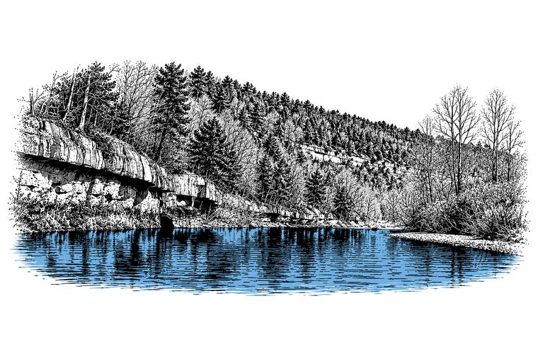
The name Cryptozoon, “hidden animal,” was given in the nineteenth century to fossils that were later recognized as stromatolitesThornberry-Ehrlich 2016, 27 (the Cryptozoon chert as the remains of “fossil algae”).. The Cryptozoon chert is a bed of those microbial mounds, turned to chert, and in places it stands out of the bluffs as a ledge. Near Blue Spring the bed is a massive reef about three feet thick, and a ledge of it juts into the riverMSS 1982, 13. at the waterline (Reach D). Field observations of the chert run along the river for about eight miles, from just above Rymers to a couple of miles above Bay CreekWeary and others 2013, GIS data (field observations of Cryptozoon chert)..
The contact shows plainly in the shape of the bluffs. Along much of the upper river the Gasconade makes the lower cliffs, and the Roubidoux makes the upper slopes. The two weather differently. The dolomite holds a sheer face, while the sandstone, sandy dolomite and chert above it break into ledges and overhangs, and slabs of sandstone wedged loose by frost and tree rootsThornberry-Ehrlich 2016, 25 (fig. 19). tumble down the slope (Chapter 2). Downstream from Jam Up Cave the contact runs about 100 feet above the river near the top of a cliff, and in 2007 a light-colored scarWeary and others 2014, cover caption; Thornberry-Ehrlich 2016, 25 (fig. 19, the same photograph, taken in March 2007, with “a relatively fresh rockfall ‘scar’”). there marked where rock had recently fallen. Upstream, the contact shows not far above the Highway 17 bridgeMSS 1982, 37 (“was observed not far above the Highway 17 bridge over the Jacks Fork”). at Steel Bridge. When the road cut for State Highway 17 was made on the north bank of the river there in the 1920s, the fresh cut gave the best Section. A square mile of 640 acres, one thirty-sixth of a township. A quarter section is 160 acres (Chapter 5). Glossary → of the Roubidoux in the vicinity. The hilltop stood about 230 feet above the river along the highway, the Roubidoux was 160 to 170 feet thick, its basal sandstone lay about an eighth of a mile north of the bridge, and below it about 58 feet of GasconadeBridge 1930, 120–21. showed down to the water. Far downstream the same contact can be seen beside Highway 106, about three-quarters of a mile west of Alley SpringThornberry-Ehrlich 2016, 15 (1.2 km, 0.73 mile)..
The contact matters underground as well. The base of the Roubidoux holds water against the dolomite beneath it, and on the upper river caves turn up again and again just below itMSS 1982, 4, 10, 34, 49. (Chapter 13). Most of the Sinkhole. A hollow in the ground where rock below has dissolved or caved in, through which water drains underground; also called a sink, an American use (Chapter 2; Chapter 12). Glossary → in the riverways country form in the Roubidoux and the Jefferson CityWeary and others 2014, 8., where sandstone layers collapse into hollows dissolved in the dolomite below them (Chapter 2).
Down through the rock
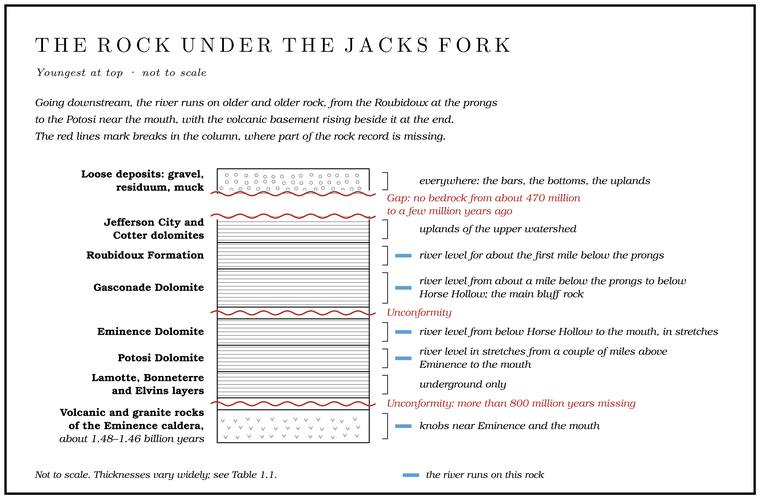
Mile by mile, the course of the Jacks Fork is a descent through the rock column.
The river leaves the Roubidoux a little past mile 1 and runs on the Gasconade for about the next 34 miles, to about mile 35, past Steel Bridge, Blue Spring, Jam Up, Rymers and Bay Creek, while the Roubidoux climbs higher and higher in the bluffs above it. The rock layers stay almost level. Geologists show this with structure contours, lines that trace the elevation of a single bedrock layer the way topographic contours trace the ground, so that a layer lying dead flat would have no contour lines at all. Along the upper river the mapped layer stays within about a hundred feetWeary and others 2013, GIS data (structure contours). of the same elevation for more than twenty miles. Over the same distance the river, falling 7 to 9 feet to the mile, drops about 180 feetthe river profile measured on the 2021–23 riverbed survey (Heimann, Atkinson and High 2025; Map 12), summed by stretch from mile 1 to mile 24. (Chapter 2). In most of the region the layers tilt no more than two or three degrees, and their gentle lean is to the south and southeast. On the upper river the water tends to flow in the direction of that tiltWeary and others 2014, 8 (dips under 2 degrees predominate, the regional trend toward the south) and cover caption; Thornberry-Ehrlich 2016, 28 (a regional average of 3 degrees to the southeast). Along the Jacks Fork valley the dip is “imperceptible” (MSS 1982, 37)..
The Gunter Sandstone at the base of the Gasconade does not show along the river until the neighborhood of Alley SpringMSS 1982, 37 (the Gunter “was not seen until in the vicinity of Alley Spring”)., and a mile or two below Horse Hollow the river cuts through it into the Eminence Dolomite. From there to the mouth the river runs on the two Cambrian dolomites, the Eminence and, in stretches from a couple of miles above Eminence down to the Current, the older PotosiWeary and others 2013 and 2014, GIS data, laid against the river centerline (Roubidoux to mile 1.15, Gasconade to about mile 35.4).. Near the mouth the volcanic knobs of the caldera rise beside it. In order downstream, the four formations of the Jacks Fork’s bed are the Roubidoux, the Gasconade, the Eminence and the PotosiThornberry-Ehrlich 2016, 11. (Part Five).
What dolomite is
Nearly every bluff on the Jacks Fork is dolomite. Dolomite is a close relative of limestone. Limestone is calcium carbonate, the same material as seashells and chalk, with almost no magnesium in it. Dolomite is calcium magnesium carbonateThornberry-Ehrlich 2016, 27., with magnesium in place of roughly half the calcium. Both begin the same way, as lime mud and shell debris on the floor of a warm, shallow sea. The rock becomes dolomite when water rich in magnesium soaks through it and makes the exchange, atom by atomgeneral., while the rock stays solid.
When that exchange happened under the Jacks Fork is still debated. Some of the dolomite probably formed early, while the sediment was fresh on or near the sea floor, and someWeary and others 2014, 5–6. much later. One reading puts the weight on the later event. Toward the end of the Paleozoic Era, roughly 300 million years ago, hot, mineral-laden water rose through the rock of southern Missouri. It left the lead and zinc ores of the Viburnum Trend, north of the riverways, part of the largest lead-mining district in the worldWeary and others 2014, 1–2., and on that reading it turned limestone that remained in the riverways into the dolomiteThornberry-Ehrlich 2016, 59, which puts the weight on the later event. seen today. The water was probably driven out of deep basins to the souththe usual explanation of ores of this kind (Mississippi Valley-type), given here as probable; the late Paleozoic timing is from Thornberry-Ehrlich 2016, 32, 59. as the Ouachita Mountains rose. The ore lies deep underground in the Bonneterre Formation, some of it draped over buried knobs of the old volcanic basement and some along faultsWeary and others 2014, 11–12 (the Fletcher and Sweetwater mines)..
Nothing shows of it at the surface, and it was found late, by drilling. At the Fletcher mine, in the southern part of the Viburnum Trend, the discovery hole went down in 1958 and the mill started in 1967. Ore at the Sweetwater mine, the southernmost in the trend, was found in 1962 and mined from 1968, and its underground workings lie inside the area that feeds springs of the Current River. Ore of the same kind lies under the basin of Blair Creek, a Current River tributary, where companies drilled it in the 1960s and kept the results to themselvesWeary and others 2014, 11–12 (the Sweetwater workings lie “within the subsurface recharge area for springs that feed the Current River,” after Feder and Barks 1972, Maxwell 1974 and Aley and Aley 1987; the Blair Creek drilling results “are proprietary”)..
The hills had their own ideas about buried metal long before the drills came. Lost silver mines are a favorite story all over the Missouri Ozarks. In the usual telling, men from Hernando de Soto’s expedition of the 1540s found a rich vein in a cave, worked it, sealed the cave and fell to killing one another on the way back, and a prospector with a degree in geology is said to have spent years hunting Shannon County for such a mine. Missouri has no native silver. Its silver comes locked inside galena, the heavy, bright gray lead ore, or in the Viburnum Trend inside the zinc ore, and a geologist of the state survey has suggested that the legends began with lumps of galena that looked like silver to whoever picked them up. Such a lump might really have held a little silver, though only smeltingSheeley 2024 (the legend as usually told; the Missouri Geological Survey’s Cheryl Seeger on silver held in galena and, in the Viburnum Trend, in sphalerite, and on galena as the likely root of the legends, given as her own view). The Shannon County prospector is named there, without dates, and is told here as a story. would have shown it.
Three of dolomite’s habits shape the river. First, it dissolves. Rainwater picks up carbon dioxide from the air and much more from the soil and becomes a weak carbonic acidThornberry-Ehrlich 2016, 13., and over long spans of time that acid eats dolomite away along its cracks and bedding planes. That is the origin of the caves, springs, sinkholes and Losing stream. A creek that gives up its flow to the bedrock and runs dry for long stretches. Jam Up Creek, Pine Hollow and Johnny Hollow are the officially listed losing streams of the watershed (Chapter 12). Glossary → of the Jacks Fork country, and of a river that keeps running clear through a dry August (Chapters 12 and 13). About 99 percentThornberry-Ehrlich 2016, 12. of the national riverways is karst, the name for country shaped by dissolving rock. Second, dolomite stands up. It is strong enough to hold a vertical face for a very long time, so the river can undercut a bluff and leave a cliff behind. Third, it makes Glade. An opening where bedrock lies at or near the surface and the soil is too thin and dry for trees, usually on a south-facing slope (Chapter 16). Glossary →. Where dolomite lies bare on a sunny slope, it carries thin soil and plants built for drought, and the open glades of the riverways come at the contactsThornberry-Ehrlich 2016, 6. between formations, between the Eminence and the Gasconade and between the Gasconade and the Roubidoux.
Chert, the rock that stays
Chert is the rock that stays behind when dolomite dissolves. It is silica, the same substance as quartz, in a form so fine-grained that it looks glassy or waxy. Most people in the Ozarks call it flint. It formed inside the dolomite as nodules, lenses and beds, from silica gathered within the sediment, and in places it replaced stromatolites and oolite grain for grain, keeping their shapes. It is very hard, and its crystals are too small to see even under an ordinary lens, and because they run every which way, the rock has no grain to split along. A blow spreads through it in a smooth, curved, shell-shaped breakgeneral description of the fracture of chert. that leaves a very sharp edge. Almost nothing in Ozark rain or groundwater dissolves it.
That last property explains the ground underfoot. When dolomite dissolves, the chert inside it is left behind, along with the sand and clay. Over millions of years the hills have lost a great thickness of rock, and the insoluble leftovers have piled up as a blanket of red or reddish-orange sandy clay full of chert, from small chips to boulders six feet across. Geologists call this blanket Residuum. The blanket of red or reddish-orange sandy clay full of chert left on the uplands as dolomite dissolves, typically about 40 feet thick in the riverways (Chapter 1; Chapter 2). Glossary →. In the riverways it is typically about 40 feet thick, about the height of a four-story building, and in places more than 100. Most of it came from the Roubidoux, and it is the greatest of all the loose deposits by volume. Being rich in clay, it is stickyThornberry-Ehrlich 2016, 23..
A geographer surveying the Missouri Ozarks in 1920 judged that the region probably held more chert than any other area of its sizeSauer 1920, 16, who judged the region to hold “probably more chert, or flint, as it is called, than any other similar area.”, and that over nine-tenths of the surface it “covers the roads, chokes the stream beds, and in many places all but obliterates the soil.” He placed Shannon County in the Courtois flint hillsSauer 1920, 190 (“in the heart of the Courtois flint hills”)., his name for the rugged hill country of the Current and Black rivers (Chapter 2).
Chert makes the Jacks Fork a gravel river. Nearly every pebble on a Jacks Fork gravel bar is chert or sandstone from the rock column above, broken, rolled and rounded on its way downhill (Chapters 2 and 15). Chert was also the stone the river’s first people chipped into dart pointsThornberry-Ehrlich 2016, 3. and tools (Chapter 3).
The state has honored the stuff. In 1967 the General Assembly made mozarkite, a chert of many colors that takes a high polish, the official state rock. It is found mainly in west-central Missouri, as boulders weathered out on hillsides and in road cuts, and it comes from the Cotter DolomiteMissouri Geological Survey 2015., which with the Jefferson City caps the uplands of the upper watershed, as around Summersvillesee “Down through the rock” above, table..
Faults and cracks
The rock under the Jacks Fork is broken by faults, fractures along which the rock on one side has moved against the rock on the other, and they run through the basement and up into the dolomites. Rock can move along a fault in three main ways. Where the crust is pulled apart, one side drops. Where it is squeezed, one side rides up over the other. Where two blocks slide past each other sideways, the layers on the two sides stay at the same height but no longer line up, and geologists call that a strike-slipThornberry-Ehrlich 2016, 33 (fig. 23). fault. The mapping of the 1920s found no faults around EminenceBridge 1930, 136 (“no faults have been observed in the Eminence area”). at all. Most are hidden under soil and gravel, and the later mappers traced them by finding layers out of place from one hillside or drill hole to the next, and by bands of crushed rock and smeared surfacesWeary and others 2014, 3. in the outcrops they could see, even in loose blocks of sandstoneThornberry-Ehrlich 2016, 33.. Along the large fault zones the rock is broken into angular rubble, much of its carbonate dissolved and replaced by silicaThornberry-Ehrlich 2016, 34 (“intensely silicified and brecciated with almost complete carbonate dissolution”)..
The faults fall into three age groups. The oldest were active only in the Mesoproterozoic and deform only the old volcanic and granite rocks. A second group moved at least once before the Ordovician layers were laid down. The third and youngest group moved at one or more times during the last 540 million years and probably earlier as well, and some of that movement probably came during the mountain-building of the late Paleozoic. Two directions dominate, northeast and northwest, and the pattern in the younger rock follows the grain of the basementWeary and others 2014, 8–9; Thornberry-Ehrlich 2016, 33. beneath it.
Several of the faults on the upper river carry the names of its hollows. Three short faults running north and northwest, the Fly Blow Hollow, Buck Hollow and Belew Hollow faults, were mapped between two longer ones, the Teresita fault on the southwest and the Houston fault on the northeast, and the three merge toward the southeast, where they either die outWeary and others 2014, 10. in the Ordovician rock or move it too little to map. On the geologic maps the Belew Hollow fault crosses and recrosses the winding river between about miles 3.6 and 6.5, above Steel Bridge, the Buck Hollow fault crosses it around Blue Spring, and the Fly Blow Hollow fault crosses just below Jam Up.
The Houston fault is the longest of them. It breaks the beds of the Gasconade in a road cut on U.S. 63 at the north edge of Houston, and farther northwest the ground on its southwest side has dropped far enough to set the Gasconade beside the Roubidoux. From Houston it has been traced southeast for about 41 milesWeary and others 2014, 10 (a “down-to-the southwest structure”; about 66 km)., to and past the Jacks Fork, which it crosses a couple of miles below Rymers. Farther downstream the inferred trace of the Low Wassie fault crosses the river just below Bay Creek. It belongs to a line of faults that geologists have read as a strike-slip zone, and drill samples from it show horizontal scratchesWeary and others 2014, 10–11. on the fault surfaces, the marks left when one block ground sideways past the other. The Hartshorn fault, which crosses about a mile above AlleyWeary and others 2013 and 2014, GIS data (faults), laid against the river centerline (the Belew Hollow fault at about miles 3.6, 3.9, 6.0 and 6.5; the Buck Hollow fault from about 9.5 to 10.8; the Fly Blow Hollow fault at about 13.6)., runs east into the western part of the old caldera. Along it, as along several others, the side that is up in one place is down in another, a reversal known as scissoringWeary and others 2014, 10–11. that also points to sideways movement. A fault named for Possum Trot Hollow crosses the river above EminenceThornberry-Ehrlich 2016, PDF 97 (geologic map, Jacks Fork to Two Rivers)..
The rock also carries joints, cracks along which it has split without moving. In the riverways the main joint sets run north-south and east-northeast. They probably opened when the crust buckled during the building of the OuachitaThornberry-Ehrlich 2016, 33–34. Mountains to the south, about 300 million years ago. Water moving through the rock widens some joints, but in the riverways most joints break only one or a few beds before they stop, so they rarely link up into a path straight down through the stack, and they play a smaller partWeary and others 2014, 8. in guiding caves than the bedding planes between the layers (Chapter 13). The fault zones too are paths for groundwater, and in the past they were paths for the hot fluidsThornberry-Ehrlich 2016, 34. that left lead ore behind.
The faults of the Jacks Fork country have been nearly still in historic times. Earthquakes recorded in the region from 1964 through 2003 were small and scattered, between Magnitude. The rank hydrologists give a spring by its average flow, in steps of ten. A first-magnitude spring averages at least 100 cubic feet a second, and a second-magnitude spring between 10 and 100 (Chapter 12). Glossary → 2.5 and 5.1, centered within about seven milesWeary and others 2014, 11 (0 to 12 km). of the surface, and usually felt only locally. The great New MadridThornberry-Ehrlich 2016, 33. earthquakes of 1811 and 1812, among the largest ever recorded in North America, happened on faults far to the southeast, along the buried Reelfoot riftWeary and others 2014, 5; the New Madrid seismic zone lies along the buried rift.. By one account Alley Spring stopped for twelve hours in 1811, the year the New Madrid shaking beganthe first great shock came on December 16, 1811 (general)., and fell five feetLewis 1980, PDF p. 53, the only source; see Reach H. (Reach H). Old earthquakes can leave a record underground as well. A hard shake can snap Stalactite, stalagmite. A stalactite hangs from a cave ceiling, built from dripping water. A stalagmite builds up from the floor where the drip lands (Chapter 13). Glossary → and knock over Stalactite, stalagmite. A stalactite hangs from a cave ceiling, built from dripping water. A stalagmite builds up from the floor where the drip lands (Chapter 13). Glossary →, and broken formations in the caves of the riverways have been studiedThornberry-Ehrlich 2016, 16 (speleothems in a park cave studied for when earthquakes occurred, after Tinsley 2014). to find out when past earthquakes struck.
The missing record
The top of the bedrock under the Jacks Fork is the Jefferson City and Cotter dolomites, about 470 million years old. Above that there is no bedrock at all. Everything from the middle of the Ordovician Period to the loose gravel of the last few million years is missing.
Missing means one of two things. Rock was laid down and later worn away, or nothing was laid down at all.
The sea came back. On hilltops and slopes across this part of the Ozarks lie jumbled blocks of chert that do not belong to any of the local layers. They lie in oval patches from a few dozen to a few hundred yards across, and not always on the highest hills. The pattern suggests that the blocks settled into old sinkholes and were let down, little by little, as the rock beneath them dissolved. They contain fossils: pieces of bryozoans, which were small colonial animals, the stems of crinoids, the molds of brachiopods, and in one block, from the Birch Tree quadrangle south of the river, the mold of a trilobite. Identified in 1998, the fossils belong to the Mississippian Period, about 359 to 323 million years ago, more than a hundred million years after the Jefferson City Dolomite formed. They come from at least two chert-rich limestone formations, the same age as the Burlington and KeokukWeary and others 2014, 6–7 (table 2: identifications by the Carnegie Museum of Natural History and the Maryland Geological Survey; “let-down residual blocks”; the paleosinkhole reading after Bridge 1930). limestones of the upper Mississippi Valley, that once covered the central Salem Plateau and have since been stripped away, leaving only their chert. On the Jam Up Cave and Pine Crest quadrangles of the upper Jacks Fork, cobbles of what appears to be reworked Mississippian chertWeary and others 2013, metadata. and sandstone, with the molds of crinoids and snails, turn up in the loose deposits.
Sometime in the Mississippian a sea covered this country again and left limestone over it, and that limestone was later eroded almost completely away. The pale conodonts set the limit: whatever lay on top of the Ordovician rocks here was never more than about 5,000 to 9,000 feetWeary and others 2014, 6. thick in all.
Mountains rose to the south. In the late Paleozoic, roughly 300 million years ago, the continents were colliding to form the supercontinent Pangaea. The Ouachita Mountains were pushed up about 124 miles south of the riverways, the Appalachians rose in the east, and the Ancestral Rocky Mountains were forming in the west. The squeeze fractured the rocks of the Ozarks, moved them along faults, and drove the hot fluidsThornberry-Ehrlich 2016, 58–59. that left lead and dolomite behind. What those events left here was fractures and minerals.
And then, for a very long time, erosion. At the dawn of the Mesozoic Era, about 252 million years ago, all the continents were joined in Pangaea. Within a few tens of millions of years they began to pull apart, opening the Atlantic Ocean and the Gulf of Mexico. During the Cretaceous Period the sea rose high enough to split North America in two along the Western Interior Seaway, and the crust between the southern Appalachians and the Ouachitas sank into a low trough, the Mississippi Embayment. The sea in the embayment reached to near Cape Girardeau, about a hundred miles east of Eminencemeasured., but it never came back over the Jacks Fork country. No rocksThornberry-Ehrlich 2016, 59. of Mesozoic age have been mapped in the riverways. The area has been dry land, exposed to the weather, since at least the CretaceousWeary and others 2014, 4., and weathering, erosion and the cutting of rivers have gone on through the 66 million years of the Cenozoic Era since then.
The dinosaur question
No dinosaur fossil has ever been found in the Jacks Fork country, and there is no rock of the right age here for one to be found in. Dinosaurs lived from about 230 million to 66 million years ago, in the Mesozoic Era. Every bedrock layer along the river is more than 200 million years older than the first dinosaur. The fossils in the bluffs are sea creatures that lived long before any animal with a backbone walked on land.
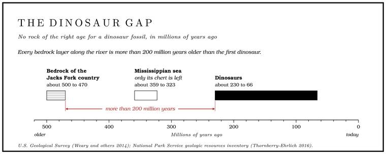
Dinosaurs may still have walked here. During the age of dinosaurs this was dry land, and land animals presumably lived on it. A bone becomes a fossil only if it is buried quickly under sediment that keeps piling up, in a delta, a swamp or a sea, and stays buried for tens of millions of years. Land that is wearing away is the opposite of that. Anything that died on the Mesozoic Ozarks was eventually washed downhill or broken down, and the record that might have shown what lived here is the part that is missing.
Missouri’s best-known dinosaur site shows where that kind of record did survive. In 1942 the Chronister family, near Glen Allen in Bollinger County, west of Cape Girardeau and about 80 miles east of Eminencemeasured., turned up large bones while digging a well, which they abandoned for lack of water. A boy named Ole Chronister led Daniel R. Stewart of the Missouri Geological Survey, who was studying clay deposits in the area, to the site, and Stewart found more bones nine feet down in the clay of the well. In 1943 Lula Chronister sold most of the bones to the Smithsonian Institution for $50. They belonged to a Late Cretaceous plant-eater that lived along the eastern shore of the Western Interior Seaway, now classed as a duck-billed dinosaur with more than a thousand teeth. Stewart and the paleontologist C. W. Gilmore announced it in 1945, and it has gone through several scientific names since. It became Missouri’s state dinosaur in 2004, and in 2022Missouri Geological Survey 2022. the legislature changed its official name to Parrosaurus missouriensis. In 2021 an adult specimen was excavated at the site and taken to the Field MuseumMissouri Secretary of State, “State Dinosaur.” in Chicago. The bones lay in clay of Late Cretaceous age, preserved in a corner of Missouri where sediment of that age piled up and survived.
The Jacks Fork country holds fossils from both ends of its missing record. In the bluffs are the Ordovician sea creatures. In the caves of the riverways are the bones of Ice Age animals, all of them from the last major glaciation or laterThornberry-Ehrlich 2016, 29., protected underground from the erosion that destroyed everything older on the surface (Chapter 13). Many were collected between the 1950s and 1980 by Oscar Hawksley, the Warrensburg biology professor who helped foundWeaver 2008, 110. the Missouri Speleological Survey, and are kept in the vertebrate paleontology collection of the Illinois State MuseumThornberry-Ehrlich 2016, 28.. Collecting fossils on park land is prohibited by federal regulation36 C.F.R. § 2.1. (Part Six).
The Ice Age, at a distance
The last episode of deep time began about 2.6 million years ago with the Pleistocene Epoch, the ice ages. Ice sheets spread across northern North America and drew back many times. The ice reached the Missouri RiverThornberry-Ehrlich 2016, 25, 59. at its farthest but never came near the Jacks Fork.
The cold reached the Ozarks anyway, speeding the weathering of the slopes and spreading wind-blown siltThornberry-Ehrlich 2016, 26, 59–60. over the hills (Chapter 2). Through the ice ages the Ozarks were a refugeThornberry-Ehrlich 2016, 7. for plants and animals pushed out of colder country. When the climate warmed, many of the northern plants died out across the south of their range and held on only where the ground stayed cool and dampMDC, “Cliffs.”. On cool, north-facing cliffs in the Jacks Fork Natural Area grows harebell, one of the plants counted as relictsMDC, Jacks Fork Natural Area; MDC, “Cliffs.” of a colder Missouri. Others on moist Ozark cliffs include red-berried elderberry and northern bedstrawMDC, “Cliffs.” (Chapter 16).
By about 12,000 years agoThornberry-Ehrlich 2016, 59. the ice ages were over. People had already come to the Ozarks (Chapter 3).
Deep time in order