The campground at Two Rivers sits on a bench of fine sediment some twenty-five or thirty feet above the CurrentMandel 2016, 4., a short walk from the place where the Jacks Fork ends. There is fresh water on two sides, Chert. A hard, fine-grained form of silica that forms in nodules and beds inside dolomite and stays behind when the dolomite dissolves. Most Ozark people call it flint. It makes up the river’s gravel and was the stone of the first people’s tools (Chapter 1; Chapter 3). Glossary → in the Gravel bar. A bank of chert gravel and sand, usually on the inside of a bend, bare at low water (Chapter 15; Chapter 18). Glossary → below, and a long view up both valleys.
People were camping on that bench long before anyone mowed it. Under the grass, as much as five feet downMandel 2016, 17. in places, lie the flakes of stone they knocked off their tools. The oldest of them were dropped near the end of the last Ice Age. The newest belong to the centuries around a thousand years agoMandel 2016, 3, 9.. Through all that time the bench seems to have served mostly as a seasonal or short-term field camp, a place where people stopped to deal with what they had hunted and gathered and to resharpen their worn tools before moving on, and it served that way for more than 13,000 yearsMandel 2016, 17 (the bench “appears to have functioned primarily as a seasonal or short-term field camp for more than 13,000 years”; the flaking done there was mostly the reduction of late-stage preforms and the resharpening of dulled tools)..
In 1977 the Park Service’s folder for floaters told visitors that the agency was “searching for evidence of early man’s habitation here.” The search had barely begun. Within ten years, archaeologists had walked plowed fields, campgrounds and gravel roads from Montauk to GooseneckPrice, Price and Saucier 1987, 18 (table 1-1)., photographed more than ten thousand artifactsPrice, Price and Saucier 1987, 37 (10,188). in private collections, and dug test excavations at ten sitesPrice, Price and Saucier 1987, 20.. By 2005 the park’s files held 480 recorded archaeological sitesFinney 2006, 1 (data as of September 2005)., and nearly everything known about them had been learned since the park was formedFinney 2006, 63 (“Virtually all knowledge of the OZAR archeological resources has been gathered since the park’s formation”)..
Most of that evidence comes from the Current, and the story of the first people has to be told for the two rivers together, because that is how it comes. The Jacks Fork has its own chapters within it, at Alley Spring, at the Shawnee Creek site below Eminence and at Two Rivers. For most of the river’s length, its ancient past has been recorded in site files and scarcely studied.
Before the archaeologists
Nineteenth-century archaeology passed these hills by. The diggers of that century went after the big mounds and earthworks of the Mississippi Bottom. The flat land along a river or creek, built of its deposits and open to its floods. In the 1920s the bottoms near Eminence averaged about a quarter of a mile wide (Chapter 2; Chapter 5). Glossary →, and when the Bureau of American Ethnology sent field agents into nine Missouri counties in 1882 and 1883, they reached the edge of the Ozarks but recorded nothing in the country of the two rivers. The bureau’s catalog of reported mounds, published in 1891Finney 2006, 40 (the Bureau of American Ethnology’s field agents under Cyrus Thomas “did not, however, survey sites in OZAR”; the 1891 compendium has “no mention of mounds in Missouri counties within OZAR”)., lists none in the counties the riverways now cover.
An early count of ancient sites in Shannon County came in 1908, when the historian Louis Houck listed 81 of them in his history of Missouri, with 189 more in Carter County. His figures came from two men, Lewis M. Bean and D. L. Hoffman, who spent two years gathering reports of some 28,000 mounds across the state. Nearly all of the Shannon County sites were “mounds,” with a large concentration along the Jacks Fork. Most were probably natural prairie mounds, also called mima mounds, low hummocks of soil that dot some Ozark uplands, which the people who reported them took for burial mounds. Burial mounds built by Indians are rare in the park. The lists do include a burial vault, rock cairns and a cache of artifacts. Texas County, by the same kind of reckoning, was credited with 793 mounds, and Dent County with 257Finney 2006, 40–41 and n. 3, after Houck 1908, 78–85 (the chapter “Extent of Pre-Historic Remains”)..
In 1918 and 1919 the archaeologist Gerard Fowke went through the caves of the central Ozarks for the Smithsonian’s Bureau of American Ethnology, looking for traces of early people, and in the caves he saw along the Current, Bat Cave and Big Creek CaveHansford and Logan 1933, 22 (his “Report on Cave Explorations in the Ozark Region of Central-Southern Missouri. 1918–1919”); Fowke 1922, letter of transmittal dated February 17, 1920, and the Current River section; Finney 2006, 41. Finney dates the work to 1921, which cannot be right, since the manuscript was transmitted for publication in February 1920. among them, he found none. Fowke was a Kentuckian, born Charles Mitchell Smith in 1855, who had once gone seven hundred miles down the Amur RiverHansford and Logan 1933, 20 (born June 25, 1855, in Mason County, Kentucky; died March 5, 1933, at Madison, Indiana). in Siberia looking for evidence that the first Americans came from Asia. His report, published in 1922, gave plain reasons for the empty caves on the Current. One was so hard to reach that nobody was likely ever to have lived in it. Another, a camping place for hunters and fishermen, took water whenever the creek or the river roseFowke 1922, Current River section (one cave “very difficult of access” and so “probably never inhabited”; another “often used as a temporary camping place by hunters and fishermen,” with water entering “whenever there is a freshet in either the creek or the river”).. He also chased a rumor. People told of a great dry cavern called the Mammoth Cave, but those who lived where it was supposed to be had never heard of it, and some thought the cave meant might lie farther off, perhaps on Jack’s Fork. He could not find itFowke 1922, Mammoth Cave entry (“it may be on Jack’s Fork”), the only source; the cave is in no catalog and is not placed.. Much of what was known in the decades that followed came from local collectors who walked plowed fields after rain and kept what they found. In 1940 James L. Lowe, a high-school teacher in Van Buren, surveyed the banks of the Current with help from the town’s Boy Scouts and reported 36 sites, and in all he is credited with recording 94 in Carter County and three in ShannonFinney 2006, 41–42.. A. A. Seamon of Alley recorded at least nine sites in Shannon County in the 1940sFinney 2006, 42., and he was the first to report the Shawnee Creek siteFinney 2006, 70; Lynott 1981, 113., which later produced the most important house on the river. Other collectors in Eminence and along the Current built large collections over many years and later shared what they knewFinney 2006, 42. with the archaeologists.
When Carl Chapman of the University of Missouri wrote the archaeological Section. A square mile of 640 acres, one thirty-sixth of a township. A quarter section is 160 acres (Chapter 5). Glossary → of the Park Service’s proposal for an Ozark national monument in 1960, he could count 45 known sites in the area, which included the Eleven Point valley. Nearly all had been reported by members of the state’s amateur archaeological societyFinney 2006, 40, 43, 63.. His large volumes of 1975 and 1980, the standard account of the state’s prehistory for a generation, said little about the Jacks Fork and the Current, because almost no professional work had been done on either river before 1971. Some took the silence to mean that the eastern Ozarks had been a cultural backwater in prehistory. The idea went back to the digging in Ozark caves and Rock shelter. An overhang wider than it is deep, with no passage behind it. Many held the camps of the first people (Chapter 3; Chapter 13). Glossary → early in the twentieth century, and it lasted until the mid-1980sFinney 2006, 43 (“some individuals took this absence as meaning the eastern Ozarks were a cultural backwater in prehistory”; the view dated from the cave and rock-shelter excavations of the early twentieth century and “was not extinguished until a 1984 publication by James Brown”)..
The park changed that. In 1971 a University of Missouri crew dug eleven test trenches on both sides of the Jacks Fork at Alley Spring, ahead of a planned parking lot and campground, in the first archaeology contractedFinney 2006, 44. inside the riverways. From 1979 Mark Lynott of the Park Service’s Midwest Archeological Center and James PriceFinney 2006, 44, 60., later the park’s own archaeologist, worked the two valleys together for many years. Between 1981 and 1985 a five-year inventory by Southwest Missouri State University’s Center for Archaeological ResearchFinney 2006, 44. surveyed field tracts, photographed collections and tested sites. A private firm excavated at Two Rivers in 1986 and again in 1987 and 1988Klinger and Kandare 1987, 1; Klinger and others 1989, abstract; NRHP, Two Rivers 1991, sec. 7., and a team from the University of Kansas and Missouri State University returned there in 2016Mandel 2016, 2..
Almost all of that work was done because something was about to be built. A federal agency has to take account of archaeological sites before it disturbs the ground54 U.S.C. § 306108 (section 106 of the National Historic Preservation Act of 1966)., which in practice means looking for them first, and since 1974 that kind of work, called Cultural resource management. Archaeology done because a federal agency must take account of sites before it disturbs the ground. Since 1974 it has made up the great bulk of the archaeology in the park (Chapter 3). Glossary →, has made up the great bulk of the archaeology in the parkFinney 2006, 11 (“Since 1974, cultural resource management (CRM) projects account for the vast majority of archeological research in the project area”).. Crews went where the Park Service planned a toilet, a road, a sewer line, a campground or a boat ramp, and the record of what has been found follows those plans.
How anyone knows
Nobody who lived on these rivers before the 1700s left writing. Everything known about them comes from things that last: stone, fired clay, charcoal, burned bone and nutshell, and the layers of the ground that hold them.
Stone tools carry the most information, because stone does not rot and toolmakers changed their styles over time. A spear point made near the end of the Ice Age looks different from a dart point of four thousand years ago, and both look different from the small arrowheads of a thousand years ago. The base of a point, where it was bound to its shaft, changed most from one period to the next. A point might be left as a plain lance shape, given a stem, or notched at the corners, the sides or the baseFinney 2006, 18 (five basic shapes, reflecting differences in hafting)., and each fashion had its time. Archaeologists use those shapes the way geologists use index fossils. A point found here is compared with points of the same shape from dated sites elsewhere, and given that age. The named periods built up this way are aids to memoryO’Brien and Wood 1998, 3 (“We view period designations and related terms almost as mnemonic devices, and when viewed as such rather than as entities that have reality, they are useful constructs”)., useful so long as nobody takes them for things that once existed in their own right.
Pottery came much later. Wet clay shrinks as it dries and again as it is fired, and a pot of clay alone tends to crack. A potter therefore mixed something into it, called Temper. Material mixed into clay to keep a pot from cracking. Here it was sand, crushed limestone or crushed mussel shell, and the choice helps date a sherd, a broken piece of pottery (Chapter 3). Glossary →, to open the clay and hold it together. In the Ozarks the choices were sand, crushed Limestone. Calcium carbonate rock formed from lime mud and shells on a sea floor. Most of the limestone laid down here later became dolomite (Chapter 1). Glossary → and crushed Mussel. A freshwater clam that lives half-buried in the riverbed and filters its food from the water. Mussels on the Jacks Fork fell sharply between the surveys of 1982 and 2017–19 (Chapter 16). Glossary → shell, and the choice changed from place to place and century to century. Limestone makes clay easy to work, swells and shrinks with heat at about the same rate as the clay around it, and gives a strong pot; in bending tests, bars of limestone-tempered clay take more force to break than bars tempered with crushed Granite. A coarse-grained rock made of magma that cooled slowly underground. Granite near Big Spring has been dated at about 1.46 billion years (Chapter 1). Glossary → or crushed fired clay. Its weakness shows after a hot firing. Heated far enough, limestone turns to quicklime, and as the pot cools the lime takes on water, swells and pops flakes out of the wallO’Brien and Wood 1998, 206 (lime spalling: heated calcite becomes calcium oxide, which takes on water as it cools and expands).. Shell has the same chemistry and the same trouble. Mississippian. In prehistory, the period from about A.D. 900 to after 1400 in radiocarbon years, of shell-tempered pottery, small arrow points and farmsteads on terraces. In geology, the period of about 359 to 323 million years ago, when the sea returned to the region at least once (Chapter 1; Chapter 3). Glossary → potters seem to have burned it first, at a heat low enough to leave it as flat platelets, so that it would crush easily, and those platelets lie flat in the clay and turn cracks aside before they can spread. Shell-tempered walls were porous, and a slip of fine clayO’Brien and Wood 1998, 250. over the surface sealed them. A broken pot under a magnifying glass can say roughly when it was made and whose ways its maker followed.
Charcoal gives a radiocarbon date. Living things take up carbon from the air, and a small, steady share of it is radioactive carbon, made high in the atmosphere by cosmic rays. After death no more comes in, and what is there decays at a fixed rate, half of it in about 5,730 years and half of the rest in the next 5,730. The amount left in a piece of charcoal measures how long ago the wood stopped growing. Every date comes with a margin, written as plus or minus so many years, and by the usual convention there are about two chances in three that the true age falls within that margin and about nineteen in twenty that it falls within twice the margin. A charcoal date belongs to the charcoal, and it carries over to the sherds or points beside it only if they went into the ground at the same timeO’Brien and Wood 1998, 10–11 (one standard deviation gives a 67 percent chance, two a 95 percent chance).. The amount of radioactive carbon in the air has not always been the same, though, so a radiocarbon age is not quite a calendar age. When radiocarbon dates were checked against wood whose age was known from its tree rings, they were sometimes off by five hundred years or more, and for parts of the oldest periods the corrected date differs from the uncorrected one by a millennium or more. Correction tables built from tree rings now turn one kind of year into the other, but not every report says whether its dates have been correctedO’Brien and Wood 1998, 11 (“Note that we say radiocarbon years, not calendar years”; “Archaeologists are supposed to tell you whether they are reporting corrected radiocarbon dates and how they were corrected. Some do, and some don’t”)., or how. The newer corrections add about two thousand yearsFinney 2006, 14. to the ages of the first hunters.
Fired clay can be dated another way, by Thermoluminescence. Dating fired pottery by the faint glow it gives off when reheated, which measures the energy gathered since it was last fired. Optically stimulated luminescence works on the same principle for buried sediment (Chapter 3). Glossary →. Clay and its temper are always being struck by weak natural radiation, and a little of that energy is caught and held in flaws in the crystals of their minerals. Firing a pot to several hundred degrees empties those traps, and the clock starts again at zero. Reheating a sherd in the laboratory releases the energy gathered since, as a faint glow, and the amount of light measures the time since the pot was fired. Those dates are calendar datesO’Brien and Wood 1998, 11–12.. A hearth can be dated by the direction of the earth’s magnetic field. Magnetic north wanders slowly over the centuries, and when a hearth’s clay cools after a hot fire, the tiny grains of iron mineral in it take on and keep a magnetism lined up with the way the field pointed at the time. Matching that direction against a regional record of where the field pointed, century by century, gives a date. The field’s wandering path can cross itself, so the same direction can fit two different times, and then the method gives two possible answersNRHP, Shawnee Creek 1989, sec. 8, cont. p. 1 (the hearth dates were read “on the southwestern curve”)..
The ground matters as much as the objects. A point lying on a gravel bar has been rolled downstream by floods and can say little more than its age. The same point sealed in silt on a Terrace. A level bench above a river, the remains of an older floodplain left high when the river cut down (Chapter 2). Glossary →, with charcoal beside it, can say when people were there and what they were doing. For that reason archaeologists on these rivers have worked beside geologists, and the shape of the valley comes up again below.
One more source has been essential, and it carries a cost. For generations, people along both rivers picked up arrowheads in plowed fields. Much of what is known about the earliest and latest periods here comes from those private collections, which researchers in the 1980s photographed piece by piece with the owners’ helpPrice, Price and Saucier 1987, 37.. Many fields once plowed have since grown up in brush or fescue, so the collections are the only record of what lay on their surface. The same collecting has also taken a great deal that can never be recovered, which comes up again below.
The long sequence
Archaeologists divide the human past here into periods named for ways of life: Paleoindian. The earliest period of people in the region, about 9250 to 7500 B.C. in radiocarbon years, known here from a few fluted points (Chapter 3). Glossary →, Archaic, Woodland and Mississippian. Authorities Draw. A valley, in the usage of the Eleven Point side of the divide in Howell County (Chapter 18). Glossary → the boundaries differently, and dates from different laboratories and methods do not always line up. Table 3.1 follows one standard set of boundaries for Missouri, given in radiocarbon years written as B.C. and A.D. The order matters more than the exact numbers, and so does how long each stretch lasted.
| Period | Dates (radiocarbon years) | What marks it on the two rivers |
|---|---|---|
| Paleoindian | about 9250–7500 B.C. | A few Fluted point. A spear point with a channel, or flute, chipped up the middle of each face, made by Paleoindian hunters (Chapter 3). Glossary →, most from the surface; fluted pieces excavated at Two Rivers and Alley Mill |
| Dalton. The late Paleoindian way of life of about 8950 to 7900 B.C. in radiocarbon years, known by serrated Dalton points and adzes. A buried Dalton base camp lies at Alley Mill (Chapter 3). Glossary → (late Paleoindian) | about 8950–7900 B.C. | Serrated Dalton points and adzesDempsey 2012, 56.; a buried Dalton camp at Alley Mill; Dalton material at Two Rivers and AkersZedeño and Basaldú 2003, 18. |
| Early Archaic | about 7500–5000 B.C. | Many point styles; seasonal camps on terraces |
| Middle Archaic | about 5000–3000 B.C. | A long warm, dry spell; camps on the terraces near the water; side-notched and stemmed points |
| Late Archaic | about 3000–600 B.C. | Many more sites, larger and denser; stemmed dart points of chert, quartzite and Rhyolite. A volcanic rock at least 72 percent silica, the rock of the knobs near Eminence and the mouth. Much of the rhyolite here is tuff (Chapter 1). Glossary →; mussels |
| Early Woodland | about 600–250 B.C. | The first pottery, rare here: a few sand-tempered sherdsO’Brien and Wood 1998, 186; Price, Price and Saucier 1987, 44. |
| Middle Woodland | about 250 B.C.–A.D. 450 | A handful of sites; stone cairns on the upper Current |
| Late Woodland | about A.D. 450–900 | Limestone-tempered, cord-marked pottery on the Jacks Fork and upper Current; the bow and arrow |
| Early Mississippian | about A.D. 900–1200 | Shell-tempered pottery made in the valleys from as early as the 600s or 700s; small arrow points; farmsteads and hamlets on terraces; the Shawnee Creek house |
| Middle Mississippian | about A.D. 1200–1400 | The eastern Ozark valleys emptied between about 1200 and 1300; fortified towns in the lowlandsO’Brien and Wood 1998, 331–34. to the southeast |
| Late Mississippian | after about A.D. 1400 | A few late arrow points left by hunting parties; no settlements |
The first hunters
At the end of the last glaciation, spruce and pine grew on the Ozark plateau. By about 12,000 radiocarbon years ago, a forest of oak and other hardwoods had replaced them. Mastodons and other animals now extinct still lived in Missouri, though they were rare in the interior of the Ozarks. The state’s records of mastodon include only a single occurrence deep in the hills, in Howell County.
The people of that time are called Paleoindians. They moved in small bands and made long, thin spear points with a channel, or flute, chipped up the middle of each face, probably to help seat the point in its shaft. The best-known style, Clovis, has been dated in radiocarbon years to between about 9250 and 8950 B.C., which the newer corrections put at about 11,000 B.C. in calendar years. A redating of ten Clovis sites in 2020 gave the whole style a life of only about three hundred years, from about 13,050 to 12,750 calendar years ago. Clovis. The best-known style of fluted spear point. A redating in 2020 gave it a life of about three hundred years, from about 13,050 to 12,750 calendar years ago (Chapter 3). Glossary → hunters and mastodons did meet in Missouri. In 1979, at a dig sponsored by the state parks, a Clovis point turned up among mastodon bones, which made the place the first site in eastern North America where the two were shown conclusively to belong together. The counties of the central Ozarks around Texas County have produced very few fluted points. Five years of work with the park’s collections in the 1980s turned up a single classic Clovis point, and on that evidence it looked as though Paleoindian people had scarcely been in the area at all. Fluted points are now known from three or four places in the park, and only at Two Rivers and Alley Mill have they come out of the ground in an excavation.
The best known of them came from Two Rivers. In 1987 or 1988 excavators recovered a small fragment from the middle of a fluted point, less than an inch long, with a flute on each face, made of a very dark, nearly black chert that came from far away. It has been identified two ways. On the first reading it is a Clovis point, of a stone like the chert of Alabama, about 250 miles off. On the second, made when the site was re-examined in 2016, it is a Sedgwick point, a style made after Clovis and closer to Folsom, the finely fluted points of the bison hunters on the Plains, than to Clovis itself, and its stone is Pitkin chert from the Boston Mountains of northern Arkansas. Either way, whoever brought it to the bench above the confluence had come a long distance, or had traded with someone who had. The same excavations turned up a fragment of a fluted end scraper in the plowed upper layer. It is thought to be the only fluted scraper recovered from any site in North America.
Dalton
By about 8950 B.C., in radiocarbon years, the glaciers had retreated and most of the large animals were gone. The Dalton people are named for a distinctive point style, and the style for a Missouri judge, S. P. Dalton. In the mid-1940s he noticed unusual points in ground turned over by road work and took them to Carl Chapman, who described them as a new type in 1948. At Rodgers Shelter in the western Ozarks, where their camps were sealed under later deposits, they hunted deer, cottontails, raccoons, squirrels, turkey and beaver and gathered hickory nuts and black walnuts. Their points are often finely serrated, like a steak knife. They also made adzes for working wood, scrapers for hides and grinding stones. Dalton points have been found in every one of Missouri’s 114 counties, the heavily dissected Ozarks included.
Dalton tools are the first to turn up regularly along the two rivers. In 1992, while looking for the remains of an earlier mill at Alley Mill, Price found a buried Dalton base camp, marked by a midden, a layer of the kind of refuse that builds up where people stay for a while. A collection from Two Rivers holds a probable Dalton point and a Dalton scraper, and the excavations there produced the base of a serrated Dalton point, weathered as though it had been rolled in water or lain long on the surface. On the upper Current, a Dalton point came out of an undisturbed layer at Akers. Dalton points are recorded from several places on the upper Jacks Fork as well.
So many Dalton points turn up on the surface in the eastern Ozarks that one archaeologist suggested the Dalton people must have looked on the hills as their private hunting preserve, and against that the small number of Dalton sites in the park comes as a surprise. They were not isolated. Ozark chert, both as raw stone and as finished tools, turns up in Dalton sites in the lowlands to the southeast, so stone was moving between the hills and the lowlands by about 8000 B.C. Dalton camps along the Ozark escarpment, where the hills drop to the lowlands, seem to have been placed for easy reach of what both had to offer. That traffic along the drainages lasted for the next nine thousand years.
The Archaic
The Archaic is the longest stretch of the story here, close to seven thousand years, more than twice as long as all the time since it ended, and the best represented. People lived by hunting, fishing, gathering mussels and collecting nuts, seeds and roots, moving through the year as each food came in. They threw their darts with a spear-thrower, or Atlatl. A spear-thrower, a short stick that adds leverage to the throw of a dart. The bow had replaced it in the Midwest by about A.D. 750 (Chapter 3). Glossary →, a short stick that adds leverage to the throw, and they sometimes weighted the stick with a polished stone. Grinding stones, a flat slab with a smaller stone held in the hand to work against it, are the main evidence that seeds were being ground for food.
The middle of the period was hard. From about 7000 B.C. a long warm, dry spell, the Hypsithermal, spread across the middle of the continent, and prairie pushed east into Missouri. The layers at Rodgers Shelter, on the Pomme de Terre River in the western Ozarks, show that between 5,000 and 8,000 years ago much of the country that carries trees today was prairie. Pronghorn, bison, prairie chickens and ground squirrels moved into central Missouri. Across much if not all of the Midwest the droughts were severe and came back again and again. On the Current the meander belts narrowed and the river carried less water. The eastern Ozarks seem to have had it easier. There the dry spell was probably milder and came later, and the woods opened into oak savanna, a long, ragged edge between forest and grass where deer, which browse on sprouts and brush, did well. A soil keeps a trace of the plants that grew in it. Trees and most Woodland. The period of prehistory from about 600 B.C. to A.D. 900 in radiocarbon years, when people here first made pottery and took up the bow (Chapter 3). Glossary → plants build their tissue with a slightly different balance of light and heavy carbon from the warm-season prairie grasses, and that balance stays in the soil’s organic matter after the plants rot. Through most of their record the soils of the Current’s valley carry mainly the woodland balance, with no sign that prairie grasses took over the valley in those millennia. Through the Middle Archaic people made more use of the lower terrace beside the river, and less of the uplands, than in any other period.
When the climate eased, people did well. A narrow valley puts two kinds of country within a short walk of each other: the bottoms and gravel bars along the river, and the oak uplands a steep climb above them. Along the Jacks Fork and the Current a band could keep one home camp through the year and still reach both, working the Floodplain. The flat valley floor that a river builds and floods (Chapter 2). Glossary → in one season and the ridges in another, and that may be part of why the valleys suited the Late Archaic way of life. Sites of the period are more numerous than those of any earlier time, and larger and denser, with many pits and broad spreads of refuse, and some of the bigger camps may have been lived in for much of the year. Along the big streams of the eastern Ozarks they sit on levees, ridge slopes and ridge tops above the valleys as well as on the terraces, and mussels from the river beds seem to have been one of the main draws. The toolmakers of the period used a good deal of orthoquartzite, a hard, sugary sandstone, and rhyolite, the volcanic rock of the Knob. The old Missouri name for a hill of hard volcanic rock, such as those near Eminence and the mouth (Chapter 1). Glossary → near Eminence and the mouth (Chapter 1). About a quarter of the park’s recorded sites have a Late Archaic component, though the count is probably too high, since any flake of quartzite has tended to be put down to that period, and at Two Rivers quartzite and rhyolite turned up through every level.
No evidence has been found that Late Archaic people on the Jacks Fork and the Current planted anything. Elsewhere in Missouri, people of this time were beginning to grow squash and bottle gourds, the first farming in the region, and squash seeds from a sealed layer at a spring site in the western Ozarks come from a horizon dated to about 2270 B.C. in radiocarbon years. By the end of the period native plants tended for their seeds, the first crops of what is called the Eastern Agricultural Complex, were being grown in Missouri as well.
Woodland: pottery and a boundary
Pottery arrived slowly. A few sand-tempered sherds from along the Jacks Fork and the Current resemble the earliest pottery of the lowlands to the southeast and of the lower Mississippi valley, made after about 600 B.C. They are so rare that Early Woodland people here are known from only a handful of sites. The Middle Woodland, from about 250 B.C., is barely better known. The park has at least five sites of that time and apparently no earthen mounds. Its best-known monuments are low stone cairns on the upper Current near Akers.
The Late Woodland is clearer, and on the Jacks Fork it has a signature. In the Late Woodland, and by one report earlier, potters across the whole Jacks Fork drainage and the upper Current tempered their clay with crushed limestone. Many of them finished a pot by beating the outside with a paddle wrapped in cord while holding a stone or a fist against the inside of the wall, which thinned and firmed the wall and left fine parallel ridges on the surface. Archaeologists call this ware Maramec Spring cordmarked. It belongs to a tradition of the Missouri River drainages to the north, which crossed the drainage divide southward into the upper reaches of the Current. The Maramec Spring pots of the eastern Ozarks that have been analyzed were all made of eastern Ozark clay, so the potters here were working in the northern manner with clay dug close to home. To the south and east, on the lower Current, the Eleven Point and the Little Black, the pottery of the time is given both as sand-tempered and as shell-tempered. The dividing line is put at different points on the middle Current, at Owls Bend or near Pulltite, and on sites close to it shell- and limestone-tempered wares turn up together, sometimes in the same sherd. The Jacks Fork lay wholly on the limestone side.
So by the first centuries A.D. there were at least two neighboring traditions on the two rivers, sharing the valleys but making things differently. Woodland people here still lived mainly by hunting and gathering. The bow and arrow came into use late in the period. An arrow is much lighter than a dart and takes a much smaller point, and judging by the sudden abundance of small arrow points, the bow had replaced the atlatl in the Midwest by about A.D. 750. Their camps cluster on terraces above the flood line, often on ground earlier people had used.
Shell temper and small farms
The biggest surprise of the 1980s concerned what came next. The Mississippian way of life, with its corn fields, its chiefs and great mound centers like Cahokia near St. Louis, was long thought to have been born in the Mississippi bottoms and to have reached the rugged eastern Ozarks late, if at all. Pottery tempered with crushed shell was its hallmark. The excavations in the park found shell-tempered pottery in the valleys earlier than anyone expected.
At Owls Bend on the Current, radiocarbon dates run from about A.D. 580 to 1020, uncorrected. At Gooseneck, farther down the Current, thermoluminescence dates on the pottery reach back to A.D. 645, give or take 120 years, and a radiocarbon date there falls near A.D. 800. Shell-tempered pottery was being made in parts of the central Mississippi valley by A.D. 800 at the latest, and perhaps even earlier in the eastern Ozarks, and there is no good reason to doubt that potters on the upland streams were using shell by late in the 600s. The great Mississippian centers to the north and east did not take up shell temper until after A.D. 1000.
In the 1980s these people were named Emergent Mississippian, a label that implies they were on the way to becoming Mississippian chiefdoms. Another reading holds that shell temper predicted no such future. On that view it means only that people along the Eleven Point River, Fourche Creek and probably other upland streams of the eastern Ozarks took up shell earlier than people elsewhere, trying out early a technique that later became the mark of the Mississippian world. The opposite idea, that the great center at Cahokia ruled the eastern Ozarks or kept them as a thinly peopled buffer, has also been put forward, and rejected as one more version of the old notion of the Ozarks as a backwater. The hills may well have supplied Cahokia with raw materials, but the valleys themselves seem to have been lived in without a break from at least 8000 B.C. until perhaps 1300.
There were a good many of these people. The park has about 45 of their sites, and they mark the high point of its prehistoric record. They lived in small farmsteads and hamlets along the valley floors, with short-term camps in rock shelters and on ridge tops. At Owls Bend people hunted mostly deer, gathered hickory nuts, hazelnuts, walnuts and acorns, and raised native seed plants of the Eastern Agricultural Complex: little barley, goosefoot, sumpweed and maygrass. At Gooseneck the excavators found deer and squirrel bones above all, along with raccoon, beaver, turkey, passenger pigeon, box turtle and fish, and seeds of grape, smartweed, sumac and corn. Corn was present, but it was not yet a staple. Their arrow points were small, and their axes and celts, ax heads made without a groove for the handle, were of a green granite that does not occur in the valleys.
The Shawnee Creek house
The Jacks Fork’s most important site of this time, the Shawnee Creek site, lies on a terrace of the lower river. Collectors had walked it for years when the archaeologists came. During the inventory of the early 1980s a crew found a single sherd of shell-tempered pottery on the surface, and two years later, in June 1985, one test pit a meter square came down on the burned floor of a house.
The builders had dug out a shallow basin and set their walls in trenches inside its edge. In a house of this kind a narrow ditch was dug along each wall, a row of poles stood upright in it and the earth packed back around them, in place of a separate Hole. Any pool deep enough to swim or fish in, named or not, the basic unit of the river in local speech; also “hole of water” (Chapter 18). Glossary → for every post, and large posts inside held up the roof. A hearth of fire-reddened earth lay on the floor, with large pieces of shell-tempered jars on it, and a complete celt of green granite, pecked and ground, lay in a corner of the basin. Charred pieces of the building lay where they had fallen when it burned, and the mold of one big inside post still held charcoal and wood the fire had not finished. The plow had come within an inch or two of the floor and cut scars across it and the hearth, and bits of charcoal, pottery and burned clay dragged up from the floor were scattered through the plowed soil above. Where the northern wall trench was opened, its dark fill stood out sharply against the yellow subsoil.
In November 1985 the Park Service went over the ground with a proton magnetometer, an instrument that measures the strength of the earth’s magnetic field point by point across a grid. Burned earth and pits filled with darker soil change the reading slightly, and those small departures, called anomalies, show where buried features lie before a spade goes in. Ten samples were taken from the hearth at the same time to read its magnetic record. Lynott’s crew returned in June 1986 to excavate the buried features the magnetometer had found, and opened three that no one had known about. Even so, all the digging together uncovered about 45 square meters, less than one percent of the site.
Wall-trench house. A house whose walls were set as rows of upright poles in a narrow ditch along each side. The one at the Shawnee Creek site, on a terrace of the lower river, was the first found anywhere in the Current River region (Chapter 3). Glossary → of this kind were common in the Mississippi bottoms. This one was the first found anywhere in the Current River region, and it showed beyond doubt that people built fully developed Mississippian houses deep in the stream valleys of the Ozark Highland.
The house held more than architecture. Two refuse pits outside it contained shell-tempered Mississippian pottery and limestone-tempered Maramec Spring ware together, with small arrow points and a broken spud, a spade-like tool, of the same green stone. A limestone-tempered sherd lay on the house floor in direct contact with the shell-tempered pottery, and some of the shell-tempered pieces contain limestone too. The people of the wall-trench house probably had pots made in the old limestone tradition of the upper Current and the plateau, perhaps by trade, or made some of their own that way, and the two wares lying together may mean that two ways of making things blended at the site or went on side by side there. Charred seeds from the site were mostly maygrass and goosefoot, with a few fragments of corn and the shells of hickory nuts, acorns, black walnuts and hazelnuts. Bone survives poorly in that soil, and the few small, badly burned pieces were of deer, turtle, turkey, squirrel, beaver and raccoon.
The dates are less tidy than they were once reported. Radiocarbon, thermoluminescence and the magnetic record of the hearth were all applied, and a summary of the results put the house at about A.D. 1025 to 1075. The individual results spread more widely. Those from the house run from about A.D. 870 to 1380, and the hearth’s magnetic record fits either 1025 to 1075 or 1225 to 1325. A radiocarbon date from one of the refuse pits came out at about A.D. 1070, and a thermoluminescence date from the other as late as 1450. Weighed together, they make it likely that the house burned sometime in the eleventh century. The site was listed on the National Register of Historic Places in 1990.
The leaving
Then the valleys emptied. Between about 1200 and 1300 the people of the upper and middle Current and the Jacks Fork stopped living there, and the leaving is dated both to around 1250 and to soon after 1300. After A.D. 1300 the eastern Ozarks appear to have been largely empty of people. One of the last Mississippian occupations in the region, in a cave on the Current below Van Buren, has radiocarbon dates of about 1160 and 1310.
Over the same years, a new kind of settlement rose in the Western Lowlands, just below the Ozark escarpment in Butler and Ripley counties. It is known as the Powers phase, a phase being a set of sites of one time and one district that share the same kinds of houses, pottery and tools. Powers Fort, a fortified town of about fifteen acres with four mounds and a civic and ceremonial center, stood at the head of a ranked set of communities: towns of Forty. Forty acres, a quarter of a quarter section. A hill farm was often one or two forties (Chapter 5). Glossary → or more houses, villages of ten or twelve, and farmsteads of one or two. More than eighty sites belong to the phase, and most of them date to the first half of the 1300s. The phase was worked out in the 1970s by James Price, before he came to work on the two rivers, from several years of survey and excavation in the lowlands. Two neighboring villages dug in that work show what such places were like. One had 48 buildings set in rows, with what may have been a small plaza between two of the rows. The other had 90 houses, 38 of them inside a walled area that held the largest, which averaged about 320 square feet, and the rest outside the wall but within a ditch that ringed the village. Their people grew corn, and their towns were placed so that they could go on fishing and hunting as people in the region long had. The communities around Powers Fort were all burned.
The leading explanation for the empty valleys is that the Ozark people moved down to the lowlands. Since late Woodland times the people of the eastern Ozarks, the escarpment and the lowlands had been using a stretch of country about 80 miles across, from the upper Current to the Little Black, and the evidence for the move is in the clay. Every bed of clay carries its own faint mix of trace elements, and a pot made from it keeps that chemical fingerprint after firing. When 397 samples of clay and pottery from fifteen sites were analyzed, by bombarding them with neutrons in a reactor and reading the elements from the radiation they gave off, the upland and lowland clays proved chemically distinct. Pots had been moving between the lowlands and the Ozark valleys for centuries, and overwhelmingly in one direction, from the lowlands up into the hills. The shell-tempered Varney pots found in the eastern Ozarks, as far west as Akers, were made of both upland and lowland clay, and the few sand-tempered Barnes sherds in the hills were all of lowland clay. Lowland pots could have come up by trade, with immigrants who afterward made pots of local clay, or with people who moved up and down the drainages with the seasons. The last two would mean a close kinship between the upland and lowland peoples, and the likeliest reading is that at least some of the people who left the eastern Ozarks around 1250 joined lowland groups already there or became the people of the Powers phase towns. Not every archaeologist agrees on the details, and the lowlands themselves were largely abandoned within a century or so. When and why that happened is still argued, with most dates falling between about 1350 and 1400 and some as late as the 1500s.
Visitors
After the valleys emptied, they were a hinterland. A few thin triangular and willow-leaf arrow points of kinds made in the 1500s and 1600s turn up in private collections, and a clay fin broken from a fish-shaped bowl, of a style made about 1500 to 1650, was found in a cave. On the Current, one such point was found lodged in the skull of a bear in a cave overlooking the river. They look like the traces of hunting trips, probably by people of the Armorel phase from the far southeast corner of Missouri and the neighboring part of Arkansas. As far as anyone knows, nobody settled in the valleys again until the nineteenth century.
Places on the Jacks Fork
The Jacks Fork has fewer known sites than the Current, and far fewer tested ones. Part of the reason is geography, and part is where archaeologists happened to look. Still, the river has three places where the record is rich, and a long upper course where it has scarcely been read (Map 3.1).
The upper river
For its first 25 miles the upper Jacks Fork runs in a deep valley contained in a canyon, with no bottomland fields. Fields are where most sites are found, because the plow brings up what lies buried and the rain washes the soil off it, and the upper river has few of them. In the inventory of the early 1980s, crews visited 14 of the 22 field tracts reported on the upper Jacks Fork. Most were overgrown or in dense fescue, a pasture grass whose thick sod hides the ground, and they recorded six sites. Ridge-top tracts were generally too brushy to survey at all. Around 1980, in a review of the park’s development areas, crews found chipped stone exposed at several river accesses on the upper river, in roads, paths and parking areas, wherever the ground was bare. A planned toilet at Blue Spring in 1983 turned up nothing.
The record has grown since then, though little of it has been published. In 1992 Price found a large prehistoric habitation, probably Archaic, along the edge of a high terrace overlooking the Jacks Fork on the upper river. In 1993 shovel tests on another upper-river tract, small holes dug at intervals and their soil sifted, found artifacts, and four test units there found none. The park’s survey of caves in the mid-1990s took in caves and rock shelters on the upper river as well. Dalton, Early Archaic and Emergent Mississippian material is now recorded from several sites on the upper river, one of them a rock shelter, and none of them has been evaluated. In 2001 violations of the federal law that protects archaeological sites were recorded at two sites on the upper river.
Alley Spring
People were at Alley Spring long before anybody built a mill there (the mill’s story belongs to Reach H). The University of Missouri crew of 1971 recorded several sites around the spring, used mostly in Archaic and Woodland times. Another, found in September 1978, lies on a high bench near the spring, built of soil washed down from the hills rather than by the river. By the time archaeologists tested it, construction had scraped up the topsoil and piled it on the floodplain below. The deposit was thoroughly churned, with prehistoric and modern objects mixed together to a depth of about sixteen inches.
Even churned, the bench was impressive. The test pits and a surface collection produced more than five thousand pieces of chipped stone, the flakes, cores and shattered waste of toolmaking, mostly of local gray and white chert, with a good deal of white quartzite. The few finished points were large dart points and knives of chert and quartzite. Private collections from the same ground add Archaic and Woodland dart points of quartzite, chert and rhyolite, possibly a Dalton point, and small arrowheads of Late Woodland and Mississippian styles from one corner of the bench. People probably camped there often, for short stays, over thousands of years, and by Mississippian times it seems to have been no more than a temporary camp.
Down by the spring, the record goes back further. The buried Dalton camp at Alley Mill held a Scottsbluff point, a long, finely made, lance-shaped point of the late Paleoindian period and the only one of its kind reported from the park, along with Early Archaic, Late Archaic and Late Woodland material. A fluted point has also come from excavations at Alley Mill. The work there showed something the surface surveys had missed. People had chosen to live at the margins of the valley, often at the mouths of tributary streams, and their camps had since been covered by soil washing down the slopes, leaving nothing on the surface to show they were there. The base of a Middle Woodland point has also turned up near the Spring branch. The stream that runs from a spring to the river, such as the branch below Alley Spring (Reach H). Glossary →. In September 1978 divers working at the spring found, under the mill turbine and wheel, a lump of iron, glass and sand that had cemented itself around the base of a side-notched dart point, tentatively of Middle Archaic age. They swam 450 feet back into the spring’s cave and down to 135 feet, looking for any sign that people had used it, and found none (Chapter 12).
Below Alley
Below Alley, and again below Eminence, the valley widens a little and terraces appear at the bends and creek mouths. These were the places the river’s pioneer farmers wanted, and earlier people wanted them first. Below Alley, the Culpepper-Pummil site spreads across a field that was row-cropped for years. Collectors had long picked up side-notched Middle Archaic points there, and the site has produced more of them, of the style called Graham Cave Side-notched, and more of the contracting-stemmed points like the Gary type of the Early Woodland, than any other site in the park. Testing in 1984 found Late Archaic, Early Woodland and Emergent Mississippian tools and a little pottery, both sand-tempered and shell-tempered, but the old refuse had been plowed into a single shallow layer with nothing intact beneath it. The site was nominated to the National Register in 1985 for its prehistoric material, and it also holds a farmstead occupied from the 1830s or 1840s into the 1860s or 1870s.
No excavation has been published at the other recorded sites on the lower river, besides the Shawnee Creek house. One, known from a private collection, was used mainly in Archaic times, and another stretches a long way along its terrace.
Two Rivers
The bench at the confluence is the best-studied place on the Jacks Fork. Lynott recorded the site in 1979 as a scatter of chipped stone with two Archaic dart points. Archaeologists tested it in 1986 for a new comfort station, sewer line and drain field, and in 1987 and 1988 they excavated in two other areas proposed for a leach field. In March 1988 the Park Service decided not to use the main excavation area, and the leach field went in near the existing comfort station, in shallow, disturbed ground. Monitoring of the construction still exposed a large number of points. The site was listed on the National Register in 1993, and in 2016 the team from Kansas and Missouri State reopened ground beside the earlier block.
It is a natural camp, standing above all but the biggest floods and overlooking two rivers. Its fine upper sediment, mostly two to three feet thick, rests on an old gravel bar, and in one hollow in the gravel it reaches five feet. Roots and burrowing animals have stirred most of that thin layer, so that things left in different periods now lie mixed together in it. A buried soil about a foot and a half down, rich in chipped stone, appears to be a living surface of the Late Archaic, very roughly three to four thousand radiocarbon years old. The only radiocarbon date from the site came from a post mold, the dark stain left by a rotted post, three to four feet down, and it came out at about 720 B.C., uncorrected. The post may mark a Late Archaic dwelling or some other kind of structure.
The excavations of 1987 and 1988 alone produced more than fifteen thousand artifacts and not a single sherd of prehistoric pottery. Points from the site span more than ten thousand years. Besides the fluted fragment and the Dalton material there are Archaic types from early to late, among them Rice Lobed, the hallmark of the Early Archaic in the southern Ozarks, the Middle Archaic Jakie Stemmed and the Late Archaic Table Rock Stemmed, along with Woodland forms and a few small arrow points of the centuries around a thousand years ago. Of the dart points that could be assigned to a type, the largest share are Late Archaic. Ninety-five percent of the stone is local chert, most of it from cobbles in the gravel bars, and most of that chert is poor. When the 2016 team tested cobbles from the old gravel, only two of the chert cobbles, and four of quartzite, were good enough to work. A bifacial tool, one shaped by flaking both faces, that came out well from that poor stone was used, resharpened and used again until it was worn out, and it often broke in the process. Much of the flaking done on the bench was the finishing of half-made blanks and the resharpening of dull edges. Rhyolite came from an outcrop on one of the volcanic knobs close by, and a few flakes of better chert came in from elsewhere.
With two floatable rivers meeting below it, each of the peoples who camped on the bench may have come and gone by canoe. Nobody can prove that, though it is hard to think of a better landing. The work of 1986 read the site as a place people returned to for short stays, probably in summer and fall, to camp and repair their gear. The deeper digging of 1987 and 1988 suggested more than that, a seasonal base camp with pits and posts.
One puzzle remains. In 1987 the excavators found mounds of gravel buried in the bench, with steep sides rising as much as three and a half feet from the old gravel surface. The relief was more than they thought floods or fallen trees could make, so they took the mounds for human work, perhaps some kind of windbreak, and tied them to the oldest people on the site. The work of 2016 found that the mounds sit on the edge of a hollow in the gravel, deeper than the surface around it, with large flakes and a big flake scraper near its bottom. That allows two readings. In one, early people took over a scour hole, or the pit left by a very large tree that blew over, as a sheltered basin, perhaps with a skin tent over it. In the other, the hollow and mounds are the natural work of a fallen tree. When a big tree goes over in a storm its roots tear up a plate of earth and stone, leaving a pit, and as the roots rot the earth they held slumps into a mound beside it; old woods are often dotted with these paired pits and mounds. Whether the feature is natural, cultural or both is unsettled. The 2016 crew also dug down into the old gravel bar beneath the bench, to about seven feet, and found no fine sediments below it that could hold anything older.
A woman whose family farmed the land early in the twentieth century told the archaeologists in 1986 that her father used to say Indians had lived on the place, because his plow kept turning up “them white rocks.”
Stone, springs and the river
What brought people to these valleys, again and again, was a bundle of things packed into a small space.
Stone. The Jacks Fork runs on chert, though not all of it is good. The chert left lying in the red clay of the uplands flakes very poorlyFinney 2006, 11 (“very poor in flaking quality”).. The toolmakers of the riverways worked chiefly with three kinds of stone from the bedrock and its gravel: the white chert of the Gasconade Dolomite, which comes in blocks as large as two feet across and is typically found as cobbles about six inches long; the often coarse chert of the Roubidoux; and the hard orthoquartzite of the Roubidoux sandstone. The Eminence Dolomite holds less than five percent chert, and the Potosi carries a thin layer of rusty, porousFinney 2006, 9. chert (Chapter 1 tells how the rock got there). As the Dolomite. Calcium magnesium carbonate rock, a close relative of limestone, formed from lime mud on the floor of a warm, shallow sea. Nearly every bluff on the Jacks Fork is dolomite (Chapter 1). Glossary → weathers away, the chert stays behind, and floods sort it into the gravel bars, where a toolmaker could pick it up at the water’s edge.
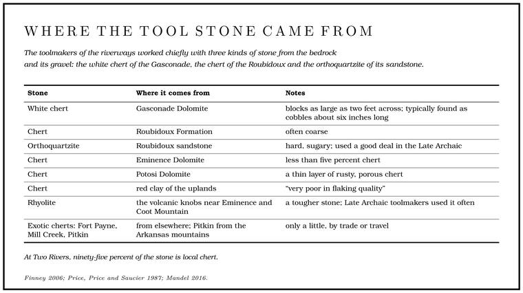
Chert breaks like glass, with sharp, predictable edges. A blow struck near the edge of a cobble at the right angle drives off a flake with a smooth, shell-shaped scar, and a skilled knapper can plan a run of such blows to thin a blank into a point. For people who made all their tools of stone, a river floored with chert gravel was a supply that never ran out, and at Alley and Two Rivers most of the chipped stone is local chert. The volcanic rhyolite of the knobs near Eminence and Coot MountainFinney 2006, 10. gave a tougher stone, and the Late Archaic toolmakers used it often. Ozark chert, and much of the hematite, galena, rhyolite and basalt found on lowland sites, probably came out of the hills. A few pieces of exotic chert, such as Fort Payne and Mill Creek chertPrice, Price and Saucier 1987, 48. and the Pitkin chertMandel 2016, 3. of the Arkansas mountains, came in by trade or travel, but only a little.
Springs. The Salem Plateau, which the two rivers drain, holds the thickest cluster of big permanent springs in MissouriZedeño and Basaldú 2003, 13 (“the largest concentration of high-volume permanent springs in Missouri”).. Spring water stays at nearly the same temperature all year, and the big springs keep flowing through droughts, which mattered in the long dry spell of the Middle Archaic. At Alley the sites cluster around the spring and its Branch. A small creek. The sense is American, on record from 1674 (Chapter 18). Glossary →. On the Current, divers found pieces of a cord-marked, limestone-tempered Woodland pot in the flooded grotto at Round Spring, under ten feet of waterCarrell, May and Garrison 1980, abstract, 37, 64.. A local legend written down in the 1930s says the round basin of that spring, about eighty feet across, was made by a mad Indian chieftain who stamped the groundO’Brien 1939, 115 (Round Spring, Shannon County, “a large round spring about 80 ft. in diameter”; informant J. T. Deatherage: “A local legend says that a mad Indian chieftain stamped the ground until the hollowed basin from which the spring flows was formed”), the only source. until it hollowed out.
The river. The rivers supplied fish, mussels, turtles and waterfowl, and the bottoms and slopes supplied deer, bear, turkey, passenger pigeons, walnuts, hickory nuts, persimmons, pawpaws, grapes and much more, all within a short walk. Local tradition remembers other uses. The bark and branches of leatherwood, a tough shrub that is one of the first in the Ozarks to bloom, are said to have served the Indians for baskets and for tying, and the scouring rush that grows in patches by the river served Indians and pioneers alike, by the same account, for cleaning their teethLewis 1980, PDF pp. 34 (leatherwood: “On account of their toughness, the bark and branches were used by the Indians for making baskets and for tying purposes”), 14 (“Scouring rushes were used by Indians and pioneers to clean their teeth”), the only source.. At Two Rivers the bench sits where the valley floor and the ridge slope meet, and between them the two offered a wide range of food and materialsKlinger and Kandare 1987, 9 (valley and slope together “provide a wide range of resources for human consumption and use”).. The rivers were also roads. Through the Archaic and much of the Woodland, new ideas and goods probably reached these valleys mostly along the drainages, up from the lowlandsPrice, Price and Saucier 1987, 46–47. of southeast Missouri, though the limestone-tempered pottery of the Late Woodland came over the divide from the north.
Why the bottoms are nearly empty
A floater on the Jacks Fork passes miles of gravel bars and low wooded flats, and it is natural to picture a camp on every one. Almost no ancient sites survive on them, and the reasons explain much about what has been found and what never will be.
The valley is narrow. Measured wall to wall, the Jacks Fork’s valley floor averages about 1,200 feet across, less than a quarter of a mile, and grows no wider downstream, while the Current’s widens from about 400 feet near Montauk to about 1,500 at GooseneckPrice, Price and Saucier 1987, 122 (Roger Saucier’s mapping of the valley floor).. In a valley that tight the river has no room to wind in loops across a broad floor. It swings instead from one wall to the other, cutting into whichever side it is pressed against. Terraces survive only in patches, usually on one side at a time, and a patch is often no larger than a few hundred acres and usually much smallerPrice, Price and Saucier 1987, 114 (“often no more than a few hundred acres in extent and usually much less”).. On the Jacks Fork about two-thirds of the valley floor is floodplain, about a fifth is the high terrace and about an eighthPrice, Price and Saucier 1987, 123. the lower one (Fig. 3.1).
People chose the terraces. The valley floor is made up of a floodplain and a set of older terraces (how terraces form is in Chapter 2). The floodplain lies within about ten feet of Low Water. The local name for the Highway Y bridge over the South Prong, the access beside it and the county’s low-water crossing where the prongs meet, and so for the head of the river (Chapter 8; Chapter 18). Glossary →Price, Price and Saucier 1987, 110. and seldom more than twenty, and most of it is wooded. Above it lie two main terraces. The lower stands about ten to twenty feet above low water, and its surface often rises and falls ten feet or more. The higher stands twenty to forty feet up and is the flattest land in the valley, seldom with more than five feet of relief, smoothed by the silt that the highest floods have spread over it a little at a time. Even the higher one goes under in floods that come, on average, more often than once in fifty years; a fifty-year flood is one with about a two percent chance of coming in any given year. The water stays only a few daysPrice, Price and Saucier 1987, 151. at a time, which never kept people from living there. In every period the higher, flatter terrace was the favorite place to live, and it is the ground settlers later cleared for their fieldsPrice, Price and Saucier 1987, 113–14.. Where there was such a terrace, people used it, and where there was none, they lived somewhere elsePrice, Price and Saucier 1987, 161 (“where the terrace was present, it was utilized; where it was absent, the Indians lived elsewhere”)..
The floodplain is younger than the people, mostly. In the 1980s the floodplain was judged too youngPrice, Price and Saucier 1987, 151. to hold prehistoric sites. In 2012 the sediments of the Current’s valley were dated by optically stimulated luminescence, which works on the same principle as thermoluminescence. Grains of quartz sand gather a charge from natural radiation while they lie buried, and sunlight empties it, so a grain carried along by floodwater in daylight starts again at zero when it settles and is covered. A beam of light in the laboratory releases what has gathered since, and that measures how long ago the grain was buried. At Round Spring on the Current the lower floodplain began building before about three thousand years ago, and it carries a buried soil that stabilized about 1,700 years ago, a surface on which Late Archaic and Woodland people could have lived. Only the uppermost layers are too young to hold anything prehistoric, and only a thin veneerDempsey 2012, 89, 92–94, 166. at the top was laid down since settlement. The upper part of the high terrace was still building between about 12,500 and 9,300 years agoDempsey 2012, 120, 166., while the first hunters and the Dalton people were in the valley.
Floods bury, but slowly. The rivers laid silt on the terraces at only a few inches per millenniumPrice, Price and Saucier 1987, 136., never fast enough to seal sites under deep, separate layers. As a result many Jacks Fork sites have been plowed into a single jumbled layer, and the deep deposits at Two Rivers are unusual. Early material may lie deeper in places than anyone has dug, in old terrace fills and in the fans of soil at the valley edges, where the work at Alley Mill found it. That is a possibility read from the sediments, and the lesson for anyone digging is to be ready to go much deeper than once seemed necessaryDempsey 2012, 169 (“Archaeologists must then be willing to excavate much deeper than they originally thought was necessary”).. Sediment from the Jacks Fork seems to have shaped the Current’s valley floor below the confluence, and dates taken below the confluence could show whether the two stretchesDempsey 2012, 155, 170. have separate histories.
Floods scour. A flood strips cleared ground. After one major flood a cleared stretch along the Jacks Fork was badly scoured, its grass sod completely strippedPrice, Price and Saucier 1987, 153 (fig. 4-18, a “severely scoured cleared area along the Jacks Fork after a major flood,” the sod “completely stripped from the floodplain surface”). from the floodplain surface. Under trees the water slows and drops its load instead. Artifacts eroded from riverbank sites end up in the gravel, and in the early 1980s hikers, canoeists, swimmers and campers were finding numerous prehistoric pieces on the gravel bars every year, rounded to varying degreesLynott 1981, 80 (“Numerous prehistoric artifacts are found annually on gravel bars by people engaged in hiking, canoeing, swimming or camping”). by rolling over the gravel.
The river moves faster than it used to. Clearcutting of the uplands, mostly between the 1890s and the 1920s, sent a wave of gravel into the valleys, and open-range grazingPrice, Price and Saucier 1987, 146–47. kept the bars bare and loose (Chapter 15). With so much new gravel to push around, the rivers reworked about 15 percent of the floodplain in the park in a hundred to a hundred and fifty years, work that by one estimate would have taken 5,000 to 10,000 yearsPrice, Price and Saucier 1987, 152. without the added gravel. On the Current, one flood left a mound of gravel and cobbles eight feet highPrice, Price and Saucier 1987, 149. in a forest. At Two Rivers, a local man told archaeologists in 1986 that about an acre of land between the store and the confluence had washed away in the previous five years or so, and that a hole thirty feet deep at the confluence had filled with gravel to about four. He believed the richest depositsKlinger and Kandare 1987, 37–38. had gone with the bank.
People did the rest. Plowing mixed the upper layers of most terrace sites. Construction leveled some, as on the bench at Alley. Campgrounds sit on exactly the flat, dry ground near water that ancient people liked, an inconvenient coincidenceLynott 1981, 77 (“The fact that these are desirable places for modern campgrounds coincides inconveniently with prehistoric and historic settlement patterns”). for anyone trying to protect the sites. Horse trails have cut deep, eroded tracks across known sites, worst at the edges of terraces and riverbanks, and moving them has been put first among the stepsFinney 2006, 79 (“the first priority”). needed to protect the park’s sites. And collectors took what lay on top.
Caves and shelters
The Bluff. A cliff along the river, usually on the outside of a bend, where the river has cut sideways into the hill. In this sense the word was first used in North America (Chapter 2; Chapter 18). Glossary → of the Jacks Fork are riddled with caves and overhangs, and the obvious question is whether people lived in them.
For a long time the answer for the Ozarks seemed to be yes. In 1924 the archaeologist Mark Harrington described what he called the Ozark Bluff-Dweller culture, from dry rock shelters in northwestern Arkansas where baskets, sandals, cradlesO’Brien 1996, 209. and woven textiles had survived for centuries. The name suggested a distinct people who lived under the bluffs. Later excavations found that the shelters held mixed layers from many periods, and the Bluff-Dwellers came to be seen as ordinary people of several different times who used dry shelters as camps. They were placed first in the Woodland and then near the end of the ArchaicO’Brien 1996, 206–7 n. 2, 209 (Carl Chapman’s placements)., and in the end the pottery, corn gardening and mound building once credited to them could not be verifiedChapman 1980, 9..
The best lesson about shelters came from Rodgers Shelter in the western Ozarks, discovered in 1962 and excavated through 1968Wood and McMillan 1976, 5–6.. Its deposits ran more than twenty-five feetO’Brien 1996, 287. deep, and its oldest layers, more than ten thousand radiocarbon years old, held the camps of Dalton people who probably stayed less than a week at a timeWood and McMillan 1976, 224.. The shelter then lay empty for some three thousand yearsWood and McMillan 1976, 225, 240. during the dry middle of the Holocene before people came back. The deep, dated layers there changed how archaeologists dugO’Brien 1996, 289. in Missouri, because they showed that a layer without artifacts is not necessarily the bottom of a site. Rock shelters are poor clocks all the same. People who camped in one again and again dug their pits and hearths into the layers of those before them, so the deposits are seldom undisturbedO’Brien and Wood 1998, 225 (rock shelters are “notoriously unreliable for chronological purposes, since their deposits are seldom undisturbed”); Finney 2006, 20. and dates from them have to be read with care.
In the riverways, a survey of caves between 1994 and 1997 examined 215 of the park’s more than 300 caves and found prehistoric material in 30 of them, about one in seven. Only five showed vandalism. Caves seem never to have counted for muchFinney 2006, 59 (caves “never played a prominent role”). in prehistoric life here, and the park has no dry cavesFinney 2006, 73. of the kind that preserved perishable goods in Arkansas. Some caves on the Current were certainly used. One below Van BurenPrice, Price and Saucier 1987, 23. held hearths of the Mississippian period above an older layer sealed under fallen rock, and the pot in the grotto at Round Spring is another example.
Which Jacks Fork caves hold such traces is not something to put in print. Cave deposits are small and fragile, and a person with a shovel can ruin one in an afternoon, so archaeologists keep their locations to themselves (Chapter 13). Burned bone, chips of stone or broken pottery in a cave on the Jacks Fork may be thousands of years old and cannot be replaced.
What can’t be known, and what shouldn’t be taken
A great deal about these people will never be known.
Their names. Nobody knows what the people of the Jacks Fork called themselves, the river or anything else, or what language they spoke. Paleoindian, Dalton, Woodland and Mississippian are labels archaeologists give to ways of making things, and none of them was ever the name of a tribe. The firmest clue to later identity is the pottery that ties the people of the two rivers to the lowland towns of southeast Missouri and northeast Arkansas. Which modern nations carry that line forward is still argued. It is plausible that the descendants of the people who once lived in the park were culturally affiliated with the Mississippian groups of the Southeast who were living along the central Mississippi River when the first European explorers, the Spanish expedition of Hernando de SotoZedeño and Basaldú 2003, 30., arrived there in 1541Zedeño and Basaldú 2003, 33–34 (the descendants “were culturally affiliated with the southeastern ‘Mississippian’ Indian groups who were living in the central Mississippi River at the time of arrival of the first European explorers in 1541”)..
The first arrivals. Whether people lived in these valleys during the Paleoindian period in any number, or only passed through, is unsettled, and the evidence is a few fluted points, mostly from the surface. At Two Rivers the search for anything older than Clovis ended at the old gravel barMandel 2016, 5. beneath the bench.
The upper river. The Prong. A branch or arm of a creek, set down in 1860 as Southern usage. The North and South Prongs join to form the Jacks Fork (Chapter 18). Glossary → and the canyon miles above Alley have had only a partial survey of their fields, and the brushy ridge topsPrice, Price and Saucier 1987, 16, 18. have scarcely been walked. What lies on the ridge tops and the small terraces of the upper Jacks Fork is known only from scattered finds in the park’s files.
What was lost. Much of what the river carried away, and much of what collectors carried home, is gone for good. A site is dated by its diagnostic pieces, the points and sherds whose styles can be placed in time, and those are the pieces collectors want. In five years of trying in the 1980s, survey crews never once reached the Culpepper site ahead of the collectors, and in almost every cultivated field they found collectors’ footprints there before them. The largest collections they photographed were carefully labeled by sitePrice, Price and Saucier 1987, 37 (“In almost every cultivated field we were greeted by footprints of collectors”).. Others were not, and a point in a cigar box with no note of where it was found has lost most of what it could have said. One of the largest collections from the two rivers was offered to the Park Service and declinedFinney 2006, 42., and only a small part of it survives at the park.
Collecting in Missouri is as old as archaeology there. In the southeastern lowlands in 1879 and 1880, people found that the pottery in the mounds would sell, and, in the words of a government report of 1894, “a regular mining fever at once broke out,” with as many as “twenty-five or thirty men, women, and children” digging for pots in one field at the same time. The pots went to merchants in a nearby town and from them to museums and relic hunters, and by one account the trade brought the town several thousand dollarsO’Brien 1996, 149, quoting Thomas 1894, 183; O’Brien and Wood 1998, 229.. Wholesale digging of that kind ebbed only when state laws were passed in the 1980sO’Brien 1996, 150.. When the State Archaeological Society of Missouri was founded in 1934Finney 2006, 41., its first aim was “to preserve the remainsO’Brien 1996, 187. of the prehistoric peoples of Missouri.” Two archaeologists warned in 1936, “At present a raceO’Brien 1996, 184, quoting Setzler and Strong 1936. between the scientist and the curio seeker is on.” An object is read through what lay around it, among other things the layer that held it, any charcoal beside it that can give a date, and the bones and seeds that show what people ate. Dug out without a record of those things, it can tell almost nothing of the story it might have toldChapman and Chapman 1983, 4 (archaeology “is not a treasure hunt”; relics dug without record “are out of context. They are almost completely valueless in determining the story they might have told if they had been properly recorded when in place”)..
Chimney Rock. One old claim about the upper river belongs here, labeled for what it is. A tourist map of Texas County drawn in 1936 and a local informant put six sites of former Indian villages in the county, one of them at Chimney RockO’Brien 1939, 66 (“There are six sites of former Indian villages in the county, one at Chimney Rock”; sources given as the tourist map and a local informant). on the upper river (Reach C). By one account, written down in 1980, before the Delaware and Shawnee arrived other tribes used the benchland across from Chimney Rock and the farm between the prongs as village sites for a long timeLewis 1980, PDF p. 11 (“Prior to the arrival of the Delaware and Shawnee, other tribes used the benchland across from Chimney Rock and on the Rich House Place as village sites,” “for a considerable length of time”), the only source; the Rich House Place is the farm in the loop between the prongs (Reach C). The 2003 affiliation study, after Price 1992, 5, gives the claim as Shawnee and Delaware “in the Bottoms opposite Chimney Rock” (Zedeño and Basaldú 2003, 82), which the 1980 text does not say.. Many artifacts are said to have come from the farm, but no village has been described at either place, and no archaeological reportthe Chimney Rock locality appears in Finney 2006, 4, only in a list of river landmarks. on either is known. The claim may preserve a real memory, an informant’s guess or a confusion with another place. If there were villages there, the story makes them older than the Delaware and Shawnee of the nineteenth century (Chapter 4).
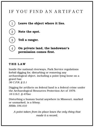
Taking things. Inside the national riverways, the Park Service’s regulations forbid36 C.F.R. § 2.1. digging for, disturbing or removing any archaeological object, including a point lying loose on a gravel bar. Digging for artifacts on federal land is also a federal crime under the Archaeological Resources Protection Act of 197916 U.S.C. § 470ee; Klinger and Kandare 1987, 1., and the damage on the upper river in 2001 was recorded as a violation of itFinney 2006, 60.. Disturbing a human burial anywhere in Missouri, marked or unmarked, is a felonyRSMo 194.410.. In 1977 the Park Service asked floaters who found Indian artifacts to hand them to a rangerNPS 1977, 1.. The better practice now is to leave the object where it lies, note the spot and tell a ranger. On private land the landowner’s permission comes first, and the same reasoning applies. A point taken from its place loses the only thing that made it a record.
Toward the Osage country
When the written record opens, the hills belong to a different people. The Osage, whose villages lay on the Osage River far to the northwest, hunted deep into the OzarksO’Brien and Wood 1998, 356., taking bear in the caves and valleys, trapping beaver and gathering persimmonsChapman 1980, 9. and nuts, and no permanent Osage villages are known in the Ozark interior. In the late eighteenth century Shawnee and Delaware families, pushed west from the Ohio country, came into southeast Missouri, and in the early nineteenthLynott 1981, 52; Zedeño and Basaldú 2003, 82. they built short-lived villages on the Current and the Jacks Fork, one of them marked on an 1821 land survey near Alley SpringFinney 2006, 56.. Their story, and the question of how the river got its name, comes next.