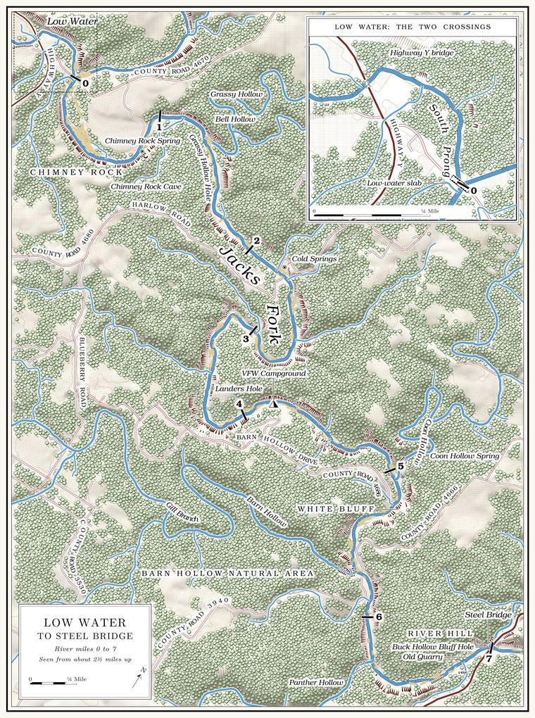
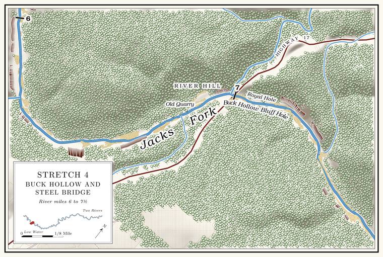
At Low Water the North Prong and the South Prong meet, and the Jacks Fork begins. For the next seven miles the river winds generally southeast in a valley cut into the plateau north of Mountain View, to the Highway 17 bridge, which Mountain View calls Steel Bridge. No state highway touches the river between the two bridges. County roads come down to it at a few places, and above the national riverways boundary both banks are private except the state’s South Prong AccessErwin 2021 (park boundary at address point 0); MDC, South Prong Access. at Low Water. Plate A3 shows the whole reach on one page, with an inset of the two crossings at Low Water.
The river here is small, quick and stony. Through this reach the river falls about 9 feet a mile, the steepest stretch of the main riverthe river profile measured on the 2021–23 riverbed survey (Heimann, Atkinson and High 2025; Map 12), which gives about 9 feet a mile from the junction to Highway 17 and less in every reach below; the 2003 float guide gives 8.6 (MDC 2003, introduction); see Chapters 2 and 20. (Chapter 2). It starts out in the sandy Roubidoux Formation and within about a mile has cut down into the Dolomite. Calcium magnesium carbonate rock, a close relative of limestone, formed from lime mud on the floor of a warm, shallow sea. Nearly every bluff on the Jacks Fork is dolomite (Chapter 1). Glossary → beneathsee Chapter 1. (Chapter 1). Below the long bends of the Big Bend the valley narrows, and tall Bluff. A cliff along the river, usually on the outside of a bend, where the river has cut sideways into the hill. In this sense the word was first used in North America (Chapter 2; Chapter 18). Glossary → on both sides give the last miles above the bridge the look of a canyonLewis 1980, PDF p. 14.. Less water is said to flow past Buck Hollow than upstreamLewis 1980, PDF p. 19, the only source.. On August 14, 2006, the river near the old VFW campground carried 23.6 cubic feet a second, an apparent loss of about 5.5 cubic feet a secondMugel, Richards and Schumacher 2009, 28 (seepage-run table: 23.6 near VFW Campground; 13.5 and 15.6 on the prongs, their sum calculated); see Chapter 12. The loss is apparent only: each of the three measurements is rated fair, within about 8 percent, and flow through a gravel streambed cannot be measured (Mugel, Richards and Schumacher 2009, 17); the same report found gaining conditions in general and no losing conditions along the Jacks Fork on its water-table map (34). from what the two Prong. A branch or arm of a creek, set down in 1860 as Southern usage. The North and South Prongs join to form the Jacks Fork (Chapter 18). Glossary → together had carried that afternoon (Chapter 12).
The national riverways reach upstream above Highway 17. The park boundary crosses the channel about 4.2 miles below the junction, in the long bends a mile and a quarter above Ratliff FordErwin, Jacobson and Jones 2021, PDF 44 (figures 34–35, distances measured from the park boundary); Erwin 2021 (address point 0, about 37.0637, −91.6992); distances measured along the river centerline traced for the maps in this book.. Below that line the Park Service lists Ratliff Ford among its Ford. A place where a road crosses through the water. Many of the river’s fords took the names of the families who lived beside them (Chapter 8). Glossary →NPS 2022a, 19; see Chapter 8. (Chapter 8) and shares Barn Hollow Natural AreaMDC, Barn Hollow Natural Area; see Chapter 11. with the state (Chapter 11).
The reach holds some of the river’s best Mussel. A freshwater clam that lives half-buried in the riverbed and filters its food from the water. Mussels on the Jacks Fork fell sharply between the surveys of 1982 and 2017–19 (Chapter 16). Glossary → water. In 2017–19 timed searches of the riverbed found no mussels, alive or dead, at five sites up the two prongs, and then 21 live ones a short way below the junction, 22 at Harlow Ford and 111 a little above Ratliff Ford, at the head of the richest stretchMcMurray and Faiman 2023, 15 (table 3, sites at river kilometers 74.8, 71.2 and 66.4); see Chapter 16. of the river, which runs down through the Jacks Fork Natural Area (Chapter 16). The man who knew the Hiker Hole, who lived at the VFW camp in the early 1990s, watched the Hole. Any pool deep enough to swim or fish in, named or not, the basic unit of the river in local speech; also “hole of water” (Chapter 18). Glossary → from the camp up both prongsJacobson and Primm 1994, 40 (table 6), 57–58; see Chapter 15 and Reach A. fill with gravel one after another (Chapter 15).
The miles in the headings are counted from the junction of the prongs along the surveyed channel. The Highway Y bridge and the South Prong Access lie a few hundred yards above mile 0, and the Highway 17 bridge is at mile 7.0measured along the river centerline traced for the maps in this book (6.98 miles to the Highway 17 bridge).. Left and right are as you face downstream.
Bend by bend
Low Water: the Highway Y bridge and South Prong Access
Bridge and access · South Prong, a few hundred yards above the junction · Plate A3 inset
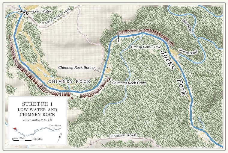
Route Y crosses the South Prong a few hundred yards above the junction, and the Missouri Department of Conservation’s South Prong Access, a tract of about 3.3 acresMDC, South Prong Access., lies beside the bridge. The bridge, the low bridge before it and the namesee Chapters 8 and 18. Low Water. The local name for the Highway Y bridge over the South Prong, the access beside it and the county’s low-water crossing where the prongs meet, and so for the head of the river (Chapter 8; Chapter 18). Glossary → are the subject of Chapters 8 and 18. A Mountain View resident who grew up on this part of the river and swam in it from the 1970s on named the hole at the Highway Y bridge as the one that has changed most and the one to warn people aboutJacks Fork Oral History, record SV-20. (Chapter 19). The South Prong above the bridge is Reach B.
The low-water slab
County low-water crossing · across the junction · mile 0 · Plate A3 inset; Fig. 15
Jacks Fork Road, County Road 4670, runs from Route W at Arroll to Route YLewis 1980, PDF p. 11. and crosses the river a few hundred yards below the Highway Y bridge on a concrete low-water slab laid across the meeting of the prongsPlate A3 inset, drawn from recent aerial imagery; see Chapter 8. (Chapter 8). An earlier Low-water bridge, low-water crossing. A road crossing built low across a stream, a ford with a floor, often a concrete slab with culvert pipes beneath it, which water overtops in a rise (Chapter 8; Chapter 18). Glossary → at the same place is said to have washed out more than onceLewis 1980, PDF p. 11, the only source.. The crossing’s local namessee Chapter 18. are in Chapter 18.
The Prongs
Junction of the North and South prongs · mile 0 · Plates A1 and A3
The North Prong arrives around a broad loop past the mouth of Buckhorn HollowUSGS GNIS; Jacks Fork Creek Network 2026; see Reach A.. The South Prong comes in under the Highway Y bridge (Reaches A and B). The South Prong is the larger of the two, draining about 88 square miles against the North Prong’s 59Jacks Fork Creek Network 2026; MDC 2001, PDF 21.. People who grew up here call the junction the Forks or the ProngsJacks Fork Oral History, records SV-19, SV-20; see Chapter 18. (Chapter 18).
The farm in the loop between the prongs is said to have been homesteaded by Richard House, known as Rich House, who by the same account joined the Confederate army. The road coming off the hill crossed the North Prong at Rich House Ford and went on up the river. A graveyard on the hill above Rich House Spring is said to hold both settlers and Indians. Nobody is sure where all its graves lie, and the uncertainty has clouded the title to four acresLewis 1980, PDF pp. 11, 12 (map), the only source. of the field. Claims that the Bottom. The flat land along a river or creek, built of its deposits and open to its floods. In the 1920s the bottoms near Eminence averaged about a quarter of a mile wide (Chapter 2; Chapter 5). Glossary → here and the bench across from Chimney Rock were Indian village sitessee Chapter 3. are weighed in Chapter 3.
Beckelshymer Spring comes in near the junction. Charles Beckelshymer, a settler from Indiana before the Civil War, is said to have kept a shed beside it for drying ginseng and, with William Baskett, to have taken the Union sideLewis 1980, PDF p. 11, the only source.. His wife, Rachel, was said to be a niece of the poet Oliver Wendell HolmesLewis 1980, PDF p. 11; unsourced there, and not checked.. A short Branch. A small creek. The sense is American, on record from 1674 (Chapter 18). Glossary → that comes in on the right a little below the junction, draining less than a square mileJacks Fork Creek Network 2026 (0.72 square mile)., is probably the hollow known as Beckelshymer HollowLewis 1980, PDF p. 12 (map). The identification is an inference from the map’s position..
Chimney Rock
Bluff and pinnacle · right bank · about mile 0.4 · Plate A3
A short way below the slab a broad cut climbs the hill on the right, the right-of-way of a former power lineLewis 1980, PDF p. 11.. As the river rounds its first bend, Chimney Rock stands out on the rightLewis 1980, PDF p. 11; USGS GNIS (Chimney Rock, cliff).: a bluff topped by a rock pinnacle, named for its chimney-like shapeO’Brien 1939, 27, from the 1936 tourist map of Texas County.. Its face rises about 180 feetthe right-bank face at about miles 0.15 to 0.57, tallest at 0.42, measured on the flood-mapping terrain (Heimann, Atkinson and High 2025; Map 13). above the water. It is on private landabove the park boundary (see the opening).. A Mountain View resident who grew up on this stretch remembered no stories about the rock but had climbed itJacks Fork Oral History, record SV-20.. A small spring flows out of the rocks on the left below the bend, and another runs through a slough into the river on the right about half a mile farther downLewis 1980, PDF p. 11..
Chimney Rock Cave and Chimney Rock Spring
Cave and spring · right bank · about mile 0.8 · Plate A3
Chimney Rock Cave lies in the hill on the right, out of sight from the riverLewis 1980, PDF p. 11.. Chimney Rock Spring takes its name from the cave, out of which it issuesO’Brien 1939, 27 (“Named for the cave from which it issues”)., and reaches the river close by. Both are on private land.
Grassy Hollow, Bell Hollow and Grassy Hollow Hole
Hollows and pool · left bank · about mile 1.3 · Plate A3
Grassy Hollow comes in from the north, draining about six square miles, and its lower miles may stop running in dry weatherJacks Fork Creek Network 2026 (6.07 square miles); MDC 2001, PDF 28–30, 90–91. and hold only Pool. A deep, slow stretch of river between riffles (Chapter 16). Glossary →. A small spring flows out of the rocks on the left above its mouth and another enters belowLewis 1980, PDF p. 14.. Bell Hollow, also called Bob Bell Hollow, joins Grassy Hollow a little over 200 yards above the river, and both run water part of the yearUSGS GNIS (Bell Hollow, mouth on Grassy Hollow about 200 meters above the river, measured on the river centerline); Lewis 1980, PDF pp. 14, 16 (map, “Bob Bell Hollow”).. The name may come from the Bell family of the Bell School, District No. 2 of Carroll Township, which was named for a Warren BellO’Brien 1939, 10. who lived near it; the 1948 topographic map prints a Bell Cemetery near the schoolUSGS 1948 (Summersville). The tie between the hollow and the Bell family is an inference., about four miles north of the river. The pool below the mouth of Grassy Hollow is Grassy Hollow Hole. The next pool down is Ike Hole, with a good spring entering below it through a slough on the rightLewis 1980, PDF pp. 14, 16 (map), the only source..
Harlow Ford and Cold Springs
Former ford, springs and mill site · about mile 2.2 · Plate A3
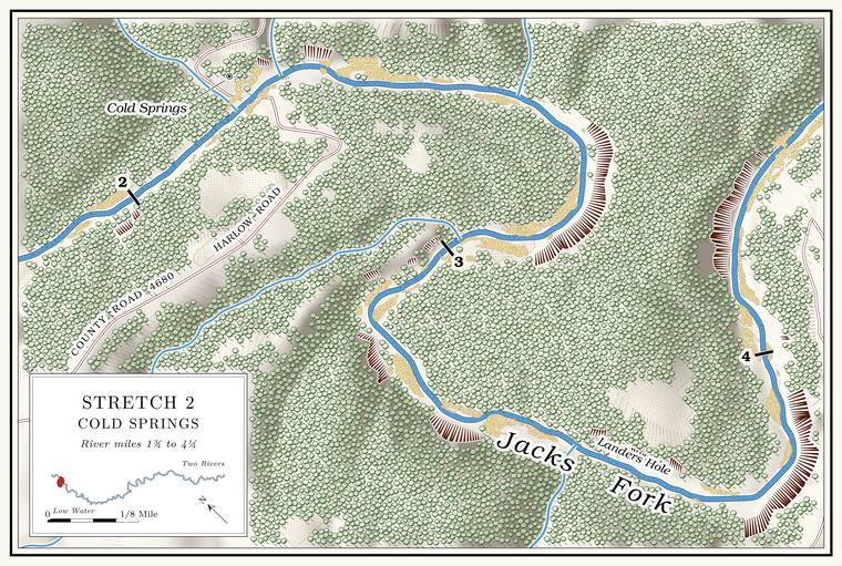
Harlow Ford crossed the river on a solid rock bottomLewis 1980, PDF p. 14.. The 1948 topographic map letters a road crossing here as Harlow FordUSGS 1948 (Summersville); USGS GNIS., and a Mountain View native who now lives in Winona marked the ford on a map at the same placeJacks Fork Oral History, record SV-19 (marked on a map within a few yards of the federal names file’s point).. The old Cold Spring Road, a trail said to be older than settlementLewis 1980, PDF pp. 14, 16 (map), the only source; see Chapter 8., crossed at the ford (Chapter 8). In 1913 backers of a bridge at the Harlow Crossingsee Chapter 8. went to court against the county’s contract for one at Buck Hollow and lost, and Harlow stayed a ford (Chapter 8).
Greenberry Harlow, said to be a son of Reuben HarlowLewis 1980, PDF p. 9., one of the county’s earliest settlersO’Brien 1939, 57; see Chapter 5. (Chapter 5), is credited with a water-powered sawmill and gristmill at the ford after the Civil War. By one account the mill was rated at 12 horsepower and ran an upright saw, and in 1869 it sawed 100,000 feet of boards worth $1,000 and ground 600 bushels of cornmeal worth $300 and 6,000 pounds of flour worth $180. In 1879 it is said to have worked on a fall of four feet and ground 600 bushels of wheat and 8,000 of corn. Greenberry’s son SamLewis 1980, PDF p. 14, the only source; the figures appear to come from the federal censuses of manufactures, which have not been checked. ran it in later years. A Harlow’s Mill post office ran from February 1875 to February 1876, with Greenberry Harlow its only postmasterLewis 1980, PDF p. 14; Rowe 2008 (Harlow’s Mills: Greensberry Harlow, February 25, 1875; discontinued February 7, 1876); Forte, Postal History, Texas County (1875–1876).. He lived on a farm on the north side of the river below the Big BendLewis 1980, PDF pp. 14, 16 (map), the only source.. Sam Harlow’s granddaughter, the story goes, was the film actress Jean HarlowLewis 1980, PDF p. 14, the only source.. She was born Harlean Carpenter in Kansas City in 1911 and took her mother’s name, Jean Harlow, for the screen, and her mother’s father was a Samuel D. Harlow, a real-estate agent in Kansas City, KansasMcClure and Richardson 1999.; whether he was Greenberry’s son Sam has not been tracedno census or family record yet ties him to Greenberry Harlow’s household (The Open Ledger).. The Harlow School and the Harlow CemeteryLewis 1980, PDF pp. 14, 16 (map), the only source. are on the ridge to the south, where the Harlows and other local families are buried.
A small spring comes out on the right a little above the ford, from under a rock with a tree growing on top of it. Below the ford a Spring branch. The stream that runs from a spring to the river, such as the branch below Alley Spring (Reach H). Glossary → enters the first pool, Cold Springs Hole. A short way up the branch the Cold Springs, two springs reputed to have been very cold, seep up through the valley floor, and the branch keeps a good flow up its narrow hollow to a source that comes out of the rocks. The springs are on the left bank. On the ridge beside the old road the Cold Springs Cemetery holds thirty or Forty. Forty acres, a quarter of a quarter section. A hill farm was often one or two forties (Chapter 5). Glossary → graves among old cedars, many of them marked with stones; the RoarkLewis 1980, PDF pp. 14, 16 (map). family is its main family, and the 1948 topographic map prints it as Cold Spring CemeteryUSGS 1948 (Summersville)..
Landers Hole and the Big Bend
Pools and bend · about miles 3.4 to 4.5 · Plate A3
Below Cold Springs Hole a spring-fed slough comes in, and the next long pool is Landers Hole. Then the river begins its longest bends. Between Harlow Ford and the mouth of Coon Hollow it runs nearly three miles to gain about a mile and a quartermeasured along the river centerline and in a straight line., and somewhere in these bends it crosses into the national riverways.
The pools of the bends carry old names whose places are not fixed. The crossing above Tune Hole was Tune Ford. The Big Bend held five big pools, from Tune Hole at its head to Rock-in-the-Hole at its foot, and four small springs on its south side, two of them beside a large patch of scouring rush. A Mountain View resident who grew up on this stretch had heard the names Big Bend and Tune HoleJacks Fork Oral History, record SV-20.. A big spring a fair distance up the hollow on the Big Bend is said to have been dammed in early times for a gristmillLewis 1980, PDF pp. 14, 16 (map), the only source..
The Stoops mill is said to have stood in this stretch, near the later VFW camp. By the same account it was a water-powered sawmill with an upright, hand-forged saw that cut lumber and ties and was working in the 1850s. It was put back to work in 1876 as a gristmill and sawmill and closed in 1880, when its millstones went upriver to another mill. It is credited to Joseph Stoops, a blacksmith, younger brother of Hugh Stoops, a circuit rider from PennsylvaniaLewis 1980, PDF pp. 14, 16 (map), the only source for these details. (Chapter 5).
The VFW campground and the Blue Hole
Former camp and pool · about miles 4.3 to 4.8 · Plate A3
A Veterans of Foreign Wars camp stood on the river below the Big Bend from at least the 1970s into the 1990s, probably on the right bank along the run below Rock-in-the-Hole, about miles 4.3 to 4.7Lewis 1980, PDF p. 16 (map: “VFW Campground” lettered south of the river with the Stoops mill, on the run from Rock-in-the-Hole to the Blue Hole), the only source for the bank.. On July 9, 1974USGS, station 07065180., the Geological Survey took a single water sample at a point it called “Jacks Fork above VFW Campground,” at about mile 4.3USGS, station 07065180 (37.0639, −91.6974, interpolated from a map), measured on the river centerline (4.28); the camp lies below this point. The 2006 site’s river mile (41.4 above the mouth) converts, against the Highway 17 gauge (38.5; measured 7.02) and the Alley Spring gauge (14.1; measured 32.05), to about mile 4.0, a little above the 1974 point., and in August 2006 its crews measured the river near the campgroundMugel, Richards and Schumacher 2009, 28; see Chapter 12. (Chapter 12). Who ran the camp and when it opened have not been traced. The man who knew the Hiker Hole lived at the camp in the early 1990sJacobson and Primm 1994, 40 (table 6), 58.. Floods, he said, now knocked out the timber at the lower ends of the big holes: “I can tell you in particular the big Blue Hole down here which used to have a lot of timber, the VFW campground used to have a lot of timber on it.”
The stretch past the VFW campground ends at the Blue Hole, by one account the deepest hole on the upper Jacks Fork and the same pool as Gar Hole, with a spring entering on its left from a crevice in the rock. It lies at the bend a short way above Coon HollowLewis 1980, PDF pp. 14, 16 (map), the only source., at about mile 4.8Lewis 1980, PDF p. 16 (map: the Blue Hole lettered where the river turns from east to southeast, with the spring on its left bank, above the mouth of Coon Hollow), measured on the river centerline (Coon Hollow’s mouth 5.01)., where the river is shallow at low water todaythe 2021–23 riverbed survey shows no pool 4 feet or deeper between about miles 4.6 and 5.2 (Heimann, Atkinson and High 2025; Map 12).. Other memories put the names elsewhere. One woman wrote “Gar Hole near Y highway” among words an outsider might not know, though she was not sure where the hole wasJacks Fork Oral History, record SV-03 (she gave the name among local words, had heard of the hole but was not sure where it was, and did not mark it on a map); see Chapter 18. (Chapter 18). A resident who came to Mountain View from Oklahoma in 1979 marked a Blue Hole a little below Highway 17 and a Gar Hole near the mouth of Belew HollowJacks Fork Oral History, record SV-05 (marked on a map); see Chapter 18 and Reach D. (Reach D). How the two names drifted is told in Chapter 18.
Coon Hollow and Coon Hollow Spring
Hollow and spring · left bank · about mile 5.1 · Plate A3
A good spring enters the river above the mouth of Coon Hollow, which comes in from the north, draining nearly six square miles. Its lower miles may stop runningJacks Fork Creek Network 2026 (5.87 square miles); MDC 2001, PDF 90–91. in dry weather. The hollow is rough, rocky and snaky. About half a mile up it is Coon Hollow Spring, a large spring with pools deeper than a person’s head, whose water sinks into the gravelLewis 1980, PDF p. 20. before it reaches the river. The hollow is said to take its name from a renegade band of Shawnee, the Coon KlanLewis 1980, PDF pp. 16 (map, “Shawnee Camp”), 20, the only source., who camped a short way above the spring and made trouble for the early settlers. The Shawnee on the Jacks Fork are the subject of Chapter 4.
White Bluff and Gobblers Knob
Bluff and hill · left bank · about mile 5.3 · Plate A3
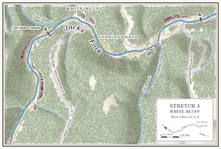
Below Coon Hollow the river runs along White Bluff, with a small, noisy spring at its upper end. The bluff stands about 170 feetthe left-bank faces at about miles 5.18 to 5.26, measured on the flood-mapping terrain (Heimann, Atkinson and High 2025; Map 13). above the water, and Gobblers Knob rises above it. A small rock overhang on the Knob. The old Missouri name for a hill of hard volcanic rock, such as those near Eminence and the mouth (Chapter 1). Glossary → carries a buried-treasure story: in the years when Spain owned Louisiana, the story goes, a party carrying silver from Potosi to Santa Fe ran into trouble with the Osage and buried the money on Gobblers Knob. Other treasure storiessee Chapter 13. of the river are in Chapter 13.
Ratliff Ford
Ford and cabins · about mile 5.5 · Plate A3
Ratliff Ford, also called Morley FordLewis 1980, PDF pp. 16 (map, “Morley (Ratliff) Ford”), 20., is the old Radcliff ford, the crossing nearest Mountain View in the 1920s. Its land deal of 1928 and the drift of its spelling from Radcliff to Ratcliff, Ratliff and Rat Cliffsee Chapters 8 and 18. are told in Chapter 8, and the names in Chapter 18. County Road 4666Plate A3. comes down to the river at the bend here.
A camp for girls from the Kansas City area is said to have stood on the right bank near the ford until the late 1920s, with a footbridge across the river; pilings of the bridge could still be seen in the Chute. A narrow, fast slot of water through a shoal or past an obstacle. A smooth V of water pointing downstream marks the deepest path through it (Chapter 20). Glossary → below in 1980. A spring enters on the right above the pilings. On the hillside on the right bank near the ford the Mountain View Health and Recreation Club kept several old cabins around 1980, privately owned and runLewis 1980, PDF pp. 16 (map), 20, the only source., probably those of the outing club that Mountain View business and professional men organized at the ford in 1928an inference; see Chapter 9. (Chapter 9). A Howell County columnist’s family, when not camping at Alley, swam at the fordWhitaker 2025 (“unless my family was camping at Alley Springs, our favorite swimming hole was upstream from the Highway 17 bridge at Ratliff Ford”); see Chapter 19. (Chapter 19). From 1991 to 1998 state biologists sampled a stretch of river at the ford every year for crayfishDiStefano and others 2003, 346–349; see Chapter 16. (Chapter 16).
Barn Hollow and Barn Hollow Natural Area
Hollow and natural area · right bank · about mile 5.7 · Plate A3
Barn Hollow is the largest side valley in the reach. It drains about fourteen square miles and runs about nine miles from its head in northern Howell CountyJacks Fork Creek Network 2026 (14.22 square miles; 14.7 kilometers); Pottenger 1945, Howell file p. 4. to the river in Texas County, and for most of its length it may stop runningMDC 2001, PDF 90–91. in dry weather. Near its lower end the creek has cut a canyon through dolomite, with vertical bluffs up to a hundred feet high, a deeply entrenched and meandering course, and a clear stream of small deep pools, short Riffle. A fast, shallow, rocky stretch between pools. The riffles are the gardens of the riverbed: in July a square meter of riffle produced more than six times as much as a square meter of pool (Chapter 16). Glossary → and beaver ponds. Forked aster, a plant of the north, grows along it. Julian Steyermark, who later wrote the standard flora of the stateSteyermark 1963., worked the canyon on August 17 and 18, 1934, and again in May 1935, and took showy lady’s-slipper from the moist bluffs at its foot and American barberry from the edge of a precipice along the river between the hollow and Highway 17University of Missouri Herbarium, Columbia, specimens 1615102 (Cypripedium reginae, August 17, 1934, “moist limestone bluffs at base of canyon, ‘Barn Hollow’ Canyon”), 1659156 (August 18, 1934), 1565255 (Berberis canadensis, May 25, 1935, “edge of limestone precipice along bluffs of Jack’s Fork of Current River, between Barn Hollow Canyon and Hwy 17”) and 1682181 (May 26, 1935).. Louisiana waterthrushes live along the water, eastern phoebes nest on the bluffs, and the ringed salamander, found only in the Ozarks, lives there along with slimy and cave salamanders, southern leopard and pickerel frogs and Blanchard’s cricket frogs (Chapter 16). The ringed salamander spends most of the year underground in the woods. On rainy nights in autumn, mostly in September and October, the adults travel to fishless Woodland. The period of prehistory from about 600 B.C. to A.D. 900 in radiocarbon years, when people here first made pottery and took up the bow (Chapter 3). Glossary → ponds to lay their eggs, and the larvae stay in the water through the winter, six to eight months or moreMDC, “Ringed Salamander.”, before they change and leave. The Conservation Department’s land at the hollow holds two small fishless ponds, about an acre of waterMDC 2016 (Barn Hollow), area summary (fishless pond, 1 acre, in two ponds). between them. Small caves and dolomite boulders line the valley slopes.
Barn Hollow Natural Area protects 190 acres of the canyon. It was designated on May 27, 1980, the same day as the Jacks Fork Natural AreaMDC, Jacks Fork Natural Area; see Chapters 11 and 16. downstream, and the Conservation Department and the Park Service own it together (Chapter 11). The Conservation Department bought its land in the hollow in 1979. It named 115 acres a Natural area. A Missouri tract set aside as one of the best remaining examples of the state’s native communities, to be managed to keep it that way. The Jacks Fork and Barn Hollow natural areas were designated on May 27, 1980 (Chapter 11). Glossary → the next year and added 30 more in 2007, and the Park Service owns the 45 acres beside themMDC 2016 (Barn Hollow), area history.. A half-mile trail leads to an overlook above the hollow. The land directly north of it, now the Conservation Department’s, was the farmstead where Sue Hubbell kept bees and wrote A Country YearMDC, Barn Hollow Natural Area.: Living the Questions (1986). She came there in 1972 with her first husband, to a farm of ninety acres. After the marriage ended in the early 1980s she was left with about 300 hives and a struggling honey business, which she kept going by writing for the St. Louis Post-Dispatch and then the New York Times. She died in Maine in 2018Bangor Daily News 2018..
Gill Branch, lettered on Plate A3, flows into Barn Hollow and carries the name of Samuel K. Gill, a Union private who settled there about 1872Pottenger 1945, Howell file p. 40.. The hollow was also called Winningham Hollow, for Isaac Winningham, who homesteaded 160 acres there in 1869. Its own name comes either from a farm of the Civil War years with several log barns or from “barren”Pottenger 1945, Howell file p. 4; see Chapter 18. (Chapter 18). The history of its spring and its schoolsee Chapters 5 and 18. is in Chapters 5 and 18. Bear Cave, one of the larger caves of the upper river, and Bat Cavesee Chapter 13. are in the Barn Hollow country (Chapter 13).
Panther Hollow and Panther Hollow Shoal
Hollow and riffle · right bank · about mile 6.2 · Plate A3
Panther Hollow, the last named hollow above Highway 17, heads in Howell County and drains a little over four square milesJacks Fork Creek Network 2026 (4.34 square miles).. It is said to have been named for the panthersPottenger 1945, Howell file p. 81; see Chapter 18. that lived there in the early days (Chapter 18). Mountain lions, the panthers of the old accounts, were all but wiped out in Missouri in the nineteenth century. The last native one known was killed in 1927, and none was confirmed in the state again until December 1994, when raccoon hunters shot one near Peck Ranch in Carter CountyHamilton 2006.. A spring enters the river nearby from a dripping bluff. The riffle beside the mouth of the hollow is Panther Hollow ShoalLewis 1980, PDF p. 24 (map)., where rough rocks are said to block a boat’s way at low waterLewis 1980, PDF p. 19, the only source.. A Mountain View resident who grew up on this stretch named the Shoal. A fast, shallow, rocky stretch between pools; a riffle. Suckers crowd onto the shoals in spring, and the old saying is that “the dogwoods bloom when the suckers are shoaling” (Chapter 18; Chapter 19). Glossary → at Panther Hollow as the hardest spot on the river to get throughJacks Fork Oral History, record SV-20..
River Hill and the Old Quarry
Highway hill and quarry · at the Highway 17 bridge · about miles 6.7 to 7.0 · Plate A3
Highway 17 comes down to the river on River Hillsee Chapter 18., a name that no map prints and that probably belongs to the descent on the Mountain View sidean inference. The people who call the descent River Hill are mostly from Mountain View, south of the river, and one person from Arroll calls it “South 17” (Jacks Fork Oral History, records SV-03, SV-09, SV-19, SV-20, SV-23); Plate A3 letters River Hill south of the river; the 1980 map letters the road hill on the north side Buck Hollow Hill (Lewis 1980, PDF p. 24). No record states the side. (Chapter 18). The steep Highway 17 Grade. The slope at which a river carries its load without cutting down or building up (Chapter 2). Glossary → at Buck Hollow are said to have caused a number of accidents and deaths. The Old Quarry lies on the right bank just above the bridgeLewis 1980, PDF p. 24 (map: the quarry symbol south of the river, between the channel and the highway, just upstream of the bridge); Plate A3., where Vernon Campbell is said to have run a lime quarry and hauled out Limestone. Calcium carbonate rock formed from lime mud and shells on a sea floor. Most of the limestone laid down here later became dolomite (Chapter 1). Glossary → until the mid-1950sLewis 1980, PDF pp. 19, 24 (map), the only source..
Places not yet placed
Hellum Spring. The good spring in Barn Hollow that changed names with its owners, from Hellum to Rushing to McCollouck, and had lost its names by 1937Pottenger 1945, Howell file p. 46; see Chapter 18. (Chapter 18). Where it is has not been found.
The Hiker Hole. The large hole, deep throughout with a bluff on one side, on the farm the man who knew it bought in 1960 (Chapter 15). By the early 1990s half of it had filledJacobson and Primm 1994, 58; see Chapter 15. with gravel. He lived at the VFW camp, and the hole may have been near it.
The Big Bend mill and the Stoops mill. The places of the dam and gristmill on the spring up the Big Bend’s hollow, and of the Stoops millLewis 1980, PDF p. 16 (map). near the VFW camp, have not been fixed on the ground.
On to Steel Bridge
Below the Old Quarry the river reaches the Highway 17 bridge at Buck Hollow, mile 7.0measured (6.98).. The pool at the bridge, lettered Buck Hollow Bluff Hole on Plate A3, has long been a favorite swimming and picnic place for families from Summersville and Mountain View, and at least three peopleLewis 1980, PDF pp. 19, 24 (map), the only source. are said to have drowned in it. It is probably the hole Mountain View calls the Steel Bridge holesee Chapter 18 and Reach D.. The bridge, the landing and the Gauge. A station of the Geological Survey that records the river’s stage, from which its flow is figured. The Jacks Fork has gauges at Highway 17, Alley and Eminence (Chapter 14). Glossary → are in Reach D (Plate A4), and the hole’s changes are in Chapter 15. Rules for the riversee Part Six. are in Part Six.