Low Water: the Highway Y bridge and South Prong Access
Bridge and access · South Prong, a few hundred yards above the junction · Plate A3 inset
Route Y crosses the South Prong a few hundred yards above the junction, and the Missouri Department of Conservation’s South Prong Access, a tract of about 3.3 acresMDC, South Prong Access., lies beside the bridge. The bridge, the low bridge before it and the namesee Chapters 8 and 18. Low Water are the subject of Chapters 8 and 18. A Mountain View resident who grew up on this part of the river and swam in it from the 1970s on named the Hole. Any pool deep enough to swim or fish in, named or not, the basic unit of the river in local speech; also “hole of water” (Chapter 18). Glossary → at the Highway Y bridge as the one that has changed most and the one to warn people about (Chapter 19). The South Prong above the bridge is Reach B.
The low-water slab
County low-water crossing · across the junction · mile 0 · Plate A3 inset; Fig. 15
Jacks Fork Road, County Road 4670, runs from Route W at Arroll to Route YLewis 1980, PDF p. 11. and crosses the river a few hundred yards below the Highway Y bridge on a concrete low-water slab laid across the meeting of the Prong. A branch or arm of a creek, set down in 1860 as Southern usage. The North and South Prongs join to form the Jacks Fork (Chapter 18). Glossary →Plate A3 inset, drawn from recent aerial imagery; see Chapter 8. (Chapter 8). An earlier Low-water bridge, low-water crossing. A road crossing built low across a stream, a ford with a floor, often a concrete slab with culvert pipes beneath it, which water overtops in a rise (Chapter 8; Chapter 18). Glossary → at the same place is said to have washed out more than onceLewis 1980, PDF p. 11, the only source.. The crossing’s local namessee Chapter 18. are in Chapter 18.
The Prongs
Junction of the North and South prongs · mile 0 · Plates A1 and A3
The North Prong arrives around a broad loop past the mouth of Buckhorn HollowUSGS GNIS; Jacks Fork Creek Network 2026; see Reach A.. The South Prong comes in under the Highway Y bridge (Reaches A and B). The South Prong is the larger of the two, draining about 88 square miles against the North Prong’s 59Jacks Fork Creek Network 2026; MDC 2001, PDF 21.. People who grew up here call the junction the Forks or the ProngsJacks Fork Oral History, records SV-19, SV-20; see Chapter 18. (Chapter 18).
The farm in the loop between the prongs is said to have been homesteaded by Richard House, known as Rich House, who by the same account joined the Confederate army. The road coming off the hill crossed the North Prong at Rich House Ford and went on up the river. A graveyard on the hill above Rich House Spring is said to hold both settlers and Indians. Nobody is sure where all its graves lie, and the uncertainty has clouded the title to four acresLewis 1980, PDF pp. 11, 12 (map), the only source. of the field. Claims that the Bottom. The flat land along a river or creek, built of its deposits and open to its floods. In the 1920s the bottoms near Eminence averaged about a quarter of a mile wide (Chapter 2; Chapter 5). Glossary → here and the bench across from Chimney Rock were Indian village sitessee Chapter 3. are weighed in Chapter 3.
Beckelshymer Spring comes in near the junction. Charles Beckelshymer, a settler from Indiana before the Civil War, is said to have kept a shed beside it for drying ginseng and, with William Baskett, to have taken the Union sideLewis 1980, PDF p. 11, the only source.. His wife, Rachel, was said to be a niece of the poet Oliver Wendell HolmesLewis 1980, PDF p. 11; unsourced there, and not checked.. A short Branch. A small creek. The sense is American, on record from 1674 (Chapter 18). Glossary → that comes in on the right a little below the junction, draining less than a square mileJacks Fork Creek Network 2026 (0.72 square mile)., is probably the hollow known as Beckelshymer HollowLewis 1980, PDF p. 12 (map). The identification is an inference from the map’s position..
Chimney Rock
Bluff and pinnacle · right bank · about mile 0.4 · Plate A3
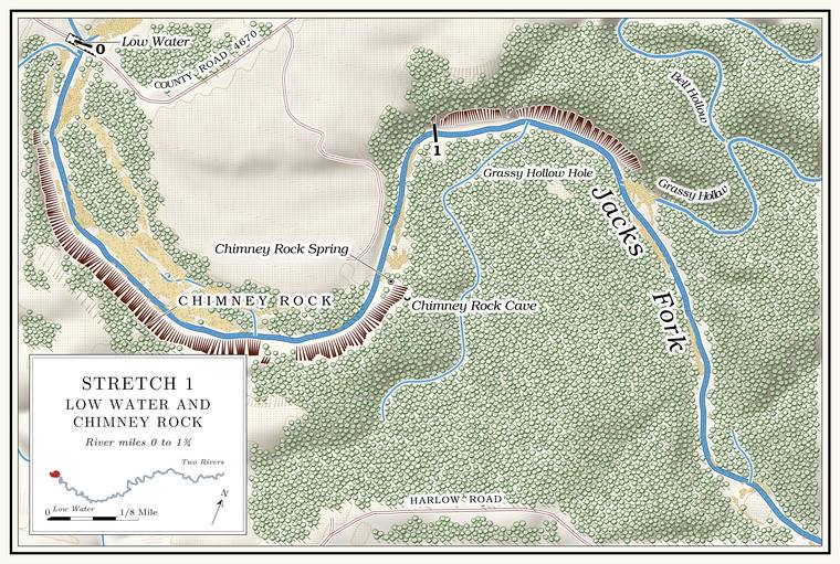
A short way below the slab a broad cut climbs the hill on the right, the right-of-way of a former power lineLewis 1980, PDF p. 11.. As the river rounds its first bend, Chimney Rock stands out on the right: a Bluff. A cliff along the river, usually on the outside of a bend, where the river has cut sideways into the hill. In this sense the word was first used in North America (Chapter 2; Chapter 18). Glossary → topped by a rock pinnacle, named for its chimney-like shapeO’Brien 1939, 27, from the 1936 tourist map of Texas County.. Its face rises about 180 feetthe right-bank face at about miles 0.15 to 0.57, tallest at 0.42, measured on the flood-mapping terrain (Heimann, Atkinson and High 2025; Map 13). above the water. It is on private landabove the park boundary (see the opening).. A Mountain View resident who grew up on this stretch remembered no stories about the rock but had climbed itJacks Fork Oral History, record SV-20.. A small spring flows out of the rocks on the left below the bend, and another runs through a slough into the river on the right about half a mile farther downLewis 1980, PDF p. 11..
Chimney Rock Cave and Chimney Rock Spring
Cave and spring · right bank · about mile 0.8 · Plate A3
Chimney Rock Cave lies in the hill on the right, out of sight from the riverLewis 1980, PDF p. 11.. Chimney Rock Spring takes its name from the cave, out of which it issuesO’Brien 1939, 27 (“Named for the cave from which it issues”)., and reaches the river close by. Both are on private land.
Grassy Hollow, Bell Hollow and Grassy Hollow Hole
Hollows and pool · left bank · about mile 1.3 · Plate A3
Grassy Hollow comes in from the north, draining about six square miles, and its lower miles may stop running in dry weatherJacks Fork Creek Network 2026 (6.07 square miles); MDC 2001, PDF 28–30, 90–91. and hold only Pool. A deep, slow stretch of river between riffles (Chapter 16). Glossary →. A small spring flows out of the rocks on the left above its mouth and another enters belowLewis 1980, PDF p. 14.. Bell Hollow, also called Bob Bell Hollow, joins Grassy Hollow a little over 200 yards above the river, and both run water part of the yearUSGS GNIS (Bell Hollow, mouth on Grassy Hollow about 200 meters above the river, measured on the river centerline); Lewis 1980, PDF pp. 14, 16 (map, “Bob Bell Hollow”).. The name may come from the Bell family of the Bell School, District No. 2 of Carroll Township, which was named for a Warren BellO’Brien 1939, 10. who lived near it; the 1948 topographic map prints a Bell Cemetery near the schoolUSGS 1948 (Summersville). The tie between the hollow and the Bell family is an inference., about four miles north of the river. The pool below the mouth of Grassy Hollow is Grassy Hollow Hole. The next pool down is Ike Hole, with a good spring entering below it through a slough on the rightLewis 1980, PDF pp. 14, 16 (map), the only source..