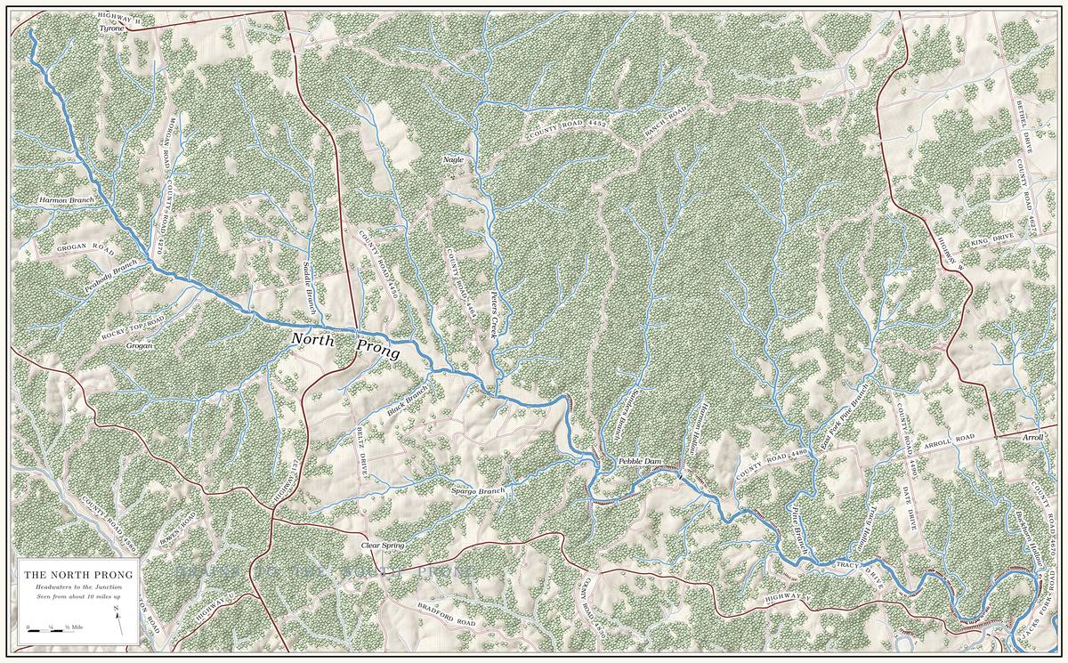
The North Prong rises on the upland about nine miles south of Raymondville and runs generally southeast across Texas County to meet the South Prong a short way below the Highway Y bridgeMDC 2001, PDF 1, 5; USGS 1948 (Clear Springs). at Low Water. Measured along its channel it is 17.04 milesmeasured along the prong centerlines traced for the maps in this book; Jacks Fork Creek Network 2026 (basins of 151.8 and 226.6 square kilometers). The state’s figures are 17.3 miles and 58.7 square miles: MDC 2001, PDF 21, 28–30. long, about a mile longer than the South Prong, and it drains about 59 square miles against the South Prong’s 88. All of it lies in Texas County, outside the national riverwaysMDC 2001, PDF 66–67 (no Park Service land in the North Prong unit); USGS GNIS., and its banks are private. Plate A1 shows the two Prong. A branch or arm of a creek, set down in 1860 as Southern usage. The North and South Prongs join to form the Jacks Fork (Chapter 18). Glossary → together, and Plate A14 shows the North Prong alone.
Through this reach the prong falls about 30 feet a milethe river profile measured on the 2021–23 riverbed survey (Heimann, Atkinson and High 2025; Map 12); the North Prong heads at about 1,420 feet. See Chapter 2.. Its first mile of channel falls at about 130 feet to the mile, and the next five miles fall between about 35 and 55 feet to the mile. A long middle course of about seven and a half miles then falls only about 16 feet to the mile, and the last four miles, from near the mouth of Pine Branch, fall about 12. From its head to the junction the prong drops roughly 500 feetMDC 2001, PDF 31–32 (tables Ge04–Ge05: 130.1, 55.9, 35.3, 15.8 and 12.2 feet per mile over 0.9, 1.7, 3.1, 7.7 and 4.0 miles).. Even its gentlest miles are steeper than the river below the Prongs, which falls about 9 feet a mile as far as Steel Bridgethe same profile (Map 12); the 2003 float guide gives 8.6 (MDC 2003, introduction). (Reach C).
About 15 of the prong’s 17 miles are mapped as permanent streamMDC 2001, PDF 28–30 (table Ge03: 15.4 of 17.3 miles).. The lowest eight miles are classed as a stream that keeps flowing in drought, and the seven above themMDC 2001, PDF 90–91 (table Wq01, from Missouri’s designated uses: class P, 8.0 miles; class C, 7.0 miles). as one that may stop flowing in dry weather but holds permanent Pool. A deep, slow stretch of river between riffles (Chapter 16). Glossary →. On August 14, 2006, the prong was carrying 13.5 cubic feet a second near its mouth and was dry at the Route 137 crossingMugel, Richards and Schumacher 2009, 19 (figure 9, a seepage run by U.S. Geological Survey hydrologists); see Chapter 12. (Chapter 12). Sinkhole. A hollow in the ground where rock below has dissolved or caved in, through which water drains underground; also called a sink, an American use (Chapter 2; Chapter 12). Glossary → are scarce in this western end of the watershed, fewer than one to a hundred square milesMDC 2001, PDF 11..
The North Prong country is more open than the watershed as a whole. In the late 1990s about seven-tenths of its basin was forest or Woodland. The period of prehistory from about 600 B.C. to A.D. 900 in radiocarbon years, when people here first made pottery and took up the bow (Chapter 3). Glossary → and a little over a quarter was grassland, against about a fifth for the whole watershedMDC 2001, PDF 65 (table Lu05: North Prong forest 66.4 percent, woodland 3.7, grassland 28.1, cropland 1.6; whole watershed grassland 20.8, cropland 1.9).. Along the stream the clearing ran deeper: on about 11 of the prong’s milesMDC 2001, PDF 98, 107 (table Hc04: 11.2 miles, 64.9 percent)., more than a quarter of the strip beside the channel was in grass, crops or buildings. Among the drainages of the watershed where wider wooded strips along the banks would do the most good, the North Prong ranks in the highest class, second only to Shawnee CreekMDC 2001, PDF 149, 155 (figure Mp01, the Missouri Department of Conservation’s riparian priorities). (Chapter 15). The man who knew the Hiker Hole (Chapter 15), whose family came to the upper basin in 1932Jacobson and Primm 1994, 39–40, 57; see Chapter 15., described the change in the early 1990s: “Back then, the fields was little islandsJacobson and Primm 1994, 42. amongst the timber; today, the timber is little islands amongst the fields.” The tie cutting along both prongs in the 1930s and 1940s is described in Chapter 7, and the spring burning of ridges and creek Bottom. The flat land along a river or creek, built of its deposits and open to its floods. In the 1920s the bottoms near Eminence averaged about a quarter of a mile wide (Chapter 2; Chapter 5). Glossary → in Chapter 5.
About a fifth of the basin is public land, nearly all of it in the Gist RanchMDC 2001, PDF 66–67 (table Lu07: 19.8 percent public, all state conservation land). Conservation Area. The Missouri Department of Conservation bought the tract, a single, heavily wooded block of about 11,240 acresMDC 2022., from the Smith Flooring Company of Mountain View in 1997. About 7,400 acres of it lie in the North Prong’s basin, and the rest lies across the divide. Gist Ranch is one of three local names for the tract, with the Kinnard Ranch and the Stoner Ranch, and none of them has been traced to its source. In the 1940s the Conservation Department leased the land as a game refuge, when it was one of the few places in Missouri where deer and wild turkeyMDC 2017 (Gist Ranch), area history (“known locally as the Gist Ranch, the Kinnard Ranch and the Stoner Ranch”; “During the 1940s, the area was leased and used as a ‘game refuge’ by the Department,” one of the few places where deer and turkey remained in the state). The purchase from Smith Flooring in March 1997 agrees with the conservation area’s own description. were still to be found. The area has small springs and fens, Dolomite. Calcium magnesium carbonate rock, a close relative of limestone, formed from lime mud on the floor of a warm, shallow sea. Nearly every bluff on the Jacks Fork is dolomite (Chapter 1). Glossary → Glade. An opening where bedrock lies at or near the surface and the soil is too thin and dry for trees, usually on a south-facing slope (Chapter 16). Glossary → on the ridges, ponds, a shooting range and about a dozen miles of trailMDC, Gist Ranch Conservation Area (which calls Gist Ranch “a local name” and gives no origin).. None of the prong’s permanent waterMDC 2001, PDF 66–67 (table Lu06: 7,400.9 acres of state conservation land in the North Prong unit; no permanent stream miles). runs through it.
People who farmed the North Prong watched its channel change in the second half of the twentieth century. A woman born in 1917, who moved to a North Prong farm in the 1920s and farmed it until 1989, saw the creek spread out and lose its swimming Hole. Any pool deep enough to swim or fish in, named or not, the basic unit of the river in local speech; also “hole of water” (Chapter 18). Glossary → after people upstream began dropping timber into it in the middle 1960sJacobson and Primm 1994, 39, 50–51. (Chapter 15). Her brothers had fished in the 1930s in “that Blue hole. A deep, still pool. On the upper river the name has been given to more than one pool (Chapter 18). Glossary →” at her mother’s place, and by the early 1990s it was “about filled up until it’s not even much to wade in”; she did not say on which prongJacobson and Primm 1994, 61 (the hole’s location is not given). it lay. The same man who knew the Hiker Hole found that after a rise in about 1991 “there was a quarter inch of mudJacobson and Primm 1994, 60. The bracketed route number is added. all over the gravel from all the way down from 17 bridge [State Route 17] all the way up the North Prong.” In 2017–19 state biologists searched two stretches of the prong for Mussel. A freshwater clam that lives half-buried in the riverbed and filters its food from the water. Mussels on the Jacks Fork fell sharply between the surveys of 1982 and 2017–19 (Chapter 16). Glossary →, both of them places where mussels had been looked for in 1982, one about five and a half miles above the junction and one about eleven and a half. They found none, alive or deadMcMurray and Faiman 2023, 12, 15 (table 3, North Prong sites at river kilometers 9.0 and 18.5, both 1982 sites). The miles are converted from the paper’s river kilometers and are approximate. (Chapter 16). A collection of the prong’s fish made on June 1, 1994, and kept at the Sternberg Museum of Natural History in Hays, Kansas, holds at least twelve kinds: central and largescale stonerollers, hornyhead and creek chubs, the Ozark minnow, telescope and bleeding shiners, the northern Hog sucker. The northern hog sucker, a bottom fish with a broad head that turns over the stones of the riverbed with its snout; also called hog molly. It is one of the giggers’ main fish, along with their “yellow sucker,” chiefly the golden redhorse (Chapter 19). Glossary →, the slender madtom, the northern studfish, and rainbow and fantail dartersSternberg Museum of Natural History, Fort Hays State University, Hays, Kansas, fish collection, catalog nos. FHSM 9991–10003 (water body “North ‘Prong’ Jacks Fork River,” Texas County; collector and exact place not recorded). Common names follow the scientific names on the lots (Campostoma anomalum, C. oligolepis, Nocomis biguttatus, Semotilus atromaculatus, Notropis nubilus, N. telescopus, Luxilus zonatus, Hypentelium nigricans, Noturus exilis, Fundulus catenatus, Etheostoma caeruleum, E. flabellare)..
The stream has been North Prong Jacks Fork on the federal maps since a decision of the Board on Geographic Names in 1966USGS GNIS, North Prong Jacks Fork (Board on Geographic Names decision).. A tourist map of Texas County made in 1936 called it the North ForkO’Brien 1939, 94 (North Fork, from the 1936 map); the map’s date, O’Brien 1939, 9., and the Park Service’s river folder of 1977NPS 1977. still used that name. By one account it was often called Steiner’s Fork, for a Steiner who at one time owned most of the land along its upper part, land first filed on by Joseph DeggendorfLewis 1980, PDF p. 9, the only source.. How the junction came to be both the Forks and the Prongs is taken up in Chapter 18.
No float on the North Prong itself is on record. People who remember high-water floats on the upper river put in at the ProngsJacks Fork Oral History, records SV-05, SV-20; see Chapter 20. (Chapter 20), and no Gauge. A station of the Geological Survey that records the river’s stage, from which its flow is figured. The Jacks Fork has gauges at Highway 17, Alley and Eminence (Chapter 14). Glossary → now stands on the prong; the nearest is at Steel Bridge (Reach D). Floating and wading on a private stream are matters of state law (Part Six).
The miles in the headings are counted upstream from the junction of the prongs, along the prong’s channel as traced from elevation data, because the main river’s miles are counted downstream from the same pointsee Reach C.. Left and right are as you face downstream (Fig. 1). The prong runs generally southeast, so its left bank is the north and east side.
Bend by bend
Headwaters
Source · about 9 miles south of Raymondville · North Prong mile 17.0 · Plate A14
The North Prong begins on the high, gentle ground of the plateau, where the heads of the Jacks Fork reach toward the main dividesee Chapter 2. of the Missouri Ozarks (Chapter 2). The nearest town is Raymondville, a village in Jackson Township named by Joseph W. Brackett for his old home in Raymond, Maine; its post office dates from the 1870sO’Brien 1939, 110 (post office from 1876).. No named spring is recorded at the head of the prong.
Harmon Branch
Branch · right bank · about North Prong mile 16
Within its first mile or so the prong takes in two Branch. A small creek. The sense is American, on record from 1674 (Chapter 18). Glossary → of about the same size at nearly the same place: Harmon Branch from the west, draining a little over a square mile, and a branch with no recorded name from the northeast that drains slightly moreUSGS GNIS; Jacks Fork Creek Network 2026.. The Harmons were among the early settlers along the upper prong. John Harmon became postmaster of the Jack’s Fork office in 1869 and George E. Harmon in 1890Lewis 1980, PDF pp. 9, 11., and George E. Harmon was appointed at Grogan in 1900Lewis 1980, PDF p. 9; Rowe 2008 (Grogan: George E. Harmon, December 5, 1900). (see Route 137 below). No record ties the branch to any one of them. The name appears twice on the prong, here near its head and again at Harmon Hollow, ten miles down.
Peabody Branch
Branch · right bank · about North Prong mile 15
Peabody Branch comes in from the southwest. It runs about a mile and three-quarters and drains about a square mile and a halfUSGS GNIS; Jacks Fork Creek Network 2026 (1.69 miles, straight line from source to mouth).. A little above its mouth a smaller branch with no recorded name enters from the northeast. Aaron T. Peabody was appointed postmaster at Grogan in 1900Lewis 1980, PDF p. 9; Rowe 2008 (Grogan: Aaron Peabody, March 28, 1900)., the same year as George E. Harmon, and the two branches at the head of the prong carry their surnames, though no record connects either branch to either man.
Saddle Branch
Branch · left bank · about North Prong mile 12.3
Saddle Branch comes down from the north, about two and three-quarter miles long and draining nearly three square miles. A few hundred yards upstream, at about mile 12.6, a creek of about the same size enters from the west on the opposite bank. It drains a little over three square milesUSGS GNIS; Jacks Fork Creek Network 2026. and has no name in any record, the largest such creek on the upper prong. A saddle is a low gap in a ridge; which gap, if any, gave the branch its name is not recorded.
Route 137 and the Nagle and Grogan neighborhoods
Highway crossing and former post offices · about North Prong mile 11.9 · positions estimated · Plates A1 and A14
Route 137 crosses the upper prong a little below Saddle Branch, about a mile above the mouth of Black Branch. The prong was dry here on August 14, 2006Mugel, Richards and Schumacher 2009, 19 (figure 9). (Chapter 12). While it was still a gravel road, into about the 1960s, its potholes were filled with gravel dug from the creeksJacobson and Primm 1994, 52 (“probably 25 years ago, 30 years ago,” counted from about 1993); see Chapter 15. (Chapter 15). A Mountain View resident who came to the area from Oklahoma in 1979 fished the North Prong by the highwayJacks Fork Oral History, record SV-05..
On the hill north of the bridge stood the Nagle church and school, lettered NogleUSGS 1948 (Clear Springs). on the 1948 topographic map, and a post office, the 86th in Texas County, opened in 1901, 1902 or 1904Lewis 1980, PDF p. 9 (from 1901); O’Brien 1939, 90 (1902); Forte, Postal History, Texas County (1904–1925).. Its postmasters ran from James M. Embree to William Lawson in 1922 and Mary Jane Lawson after him, and it closed in 1925. The office took its name from the C. H. Nagle family, landowners, as did a Methodist church and a school; it is also placed in Ozark TownshipO’Brien 1939, 90, the only source for the township; Forte, Postal History, Texas County, also closes the office in 1925., and the name Nagle still marks a place on the upland near hereUSGS GNIS (Nagle, 37.1667, −91.8193).. Joseph Nagle, a preacher, held services at the Nagle church and at the Rocky Ford churchLewis 1980, PDF p. 9. down the prong (see Tracy Hollow below).
The Grogan school and post office stood about three miles up the creek. The office ran from September 1897 to January 1954, when its mail went to Tyrone. Its name is traced both to its first postmaster, William B. GroganUSGS GNIS; USGS 1948 (Clear Springs). (also spelled Grogran)Lewis 1980, PDF p. 9 (Lewis spells it Grogran); Rowe 2008 (Grogan: William B. Grogan, September 16, 1897; mail to Tyrone); Forte, Postal History, Texas County (1897–1954)., and to J. E. Grogan, on whose land it was established; it is also dated from 1899 and placed in southeastern Cass TownshipO’Brien 1939, 55..
Black Branch
Branch · right bank · about North Prong mile 10.7
Black Branch is a branch of nearly two miles from the southwest, draining a little less than a square mile. The Blacks were an early family here, settled before the Civil WarLewis 1980, PDF p. 9, the only source.. A little below it, at about mile 10.4, a creek of about two and a half square milesUSGS GNIS; Jacks Fork Creek Network 2026 (1.83 miles, straight line from source to mouth). enters from the north on the left bank. It has no recorded name.
Peters Creek
Creek · left bank · North Prong mile 9.6 · Plate A14
Peters Creek is the North Prong’s largest tributary. It drains nearly 12 square milesJacks Fork Creek Network 2026. from the north and runs between five and a half and seven miles, depending on the measurement. Only about two and a third of its miles are mapped as permanent stream, and its lower three and a half milesJacks Fork Creek Network 2026; MDC 2001, PDF 28–30, 90–91. are classed as water that may stop flowing in dry weather but keeps permanent pools. It heads in the Gist Ranch country and is the only stream named on the conservation area’s mapMDC, Gist Ranch Conservation Area (area map).. Several smaller branches feed it, none of them named.
The creek takes its name from a cattle ranch. The Western Land and Cattle Company, founded in London in 1881, bought 28,000 acres in Texas County in 1883, including the land along the North Prong. Charles E. Peter came from Scotland in 1885 to manage it, the property became known as Peter’s Ranch, and the creek was named for him. About 14,000 acres of the ranch lay along the North Prong, and in 1980 the tract was still in one piece, grown to about 18,000 acresLewis 1980, PDF p. 9, the only source (the scan reads “14,00”; read here as 14,000).. Whether the conservation area is part of the same block of land has not been traced through the deeds (The Open Ledger).
The mouth of Peters Creek lies on the federal map sheet named for Eunice, a village to the north, named for the wife of W. B. Cooper, who opened its post office in 1891O’Brien 1939, 45..
Sanders Branch, Spargo Branch and the old mill
Branches, mill site and road crossing · Sanders Branch left bank, Spargo Branch right · about North Prong miles 8.2 to 7.8 · Plate A14
Two creeks of about three square miles each reach the prong about a third of a mile apart here. The upper one, Spargo Branch, comes from the west on the right bank at about mile 8.2. The lower one, Sanders Branch, comes from the northeast on the left bank at mile 7.8, runs about four miles and drains about three and a half square milesJacks Fork Creek Network 2026 (Sanders Branch 4.1 miles, straight line from source to mouth).. Every map that names them, from the 1948 topographic sheet on, places them soUSGS 1948 (Clear Springs); USGS GNIS (sources to the west and to the northeast); Lewis 1980, PDF p. 10 (map).. Neither name has an explanation on record.
A gristmill stood on the prong a little above the mouth of Sanders Branch and was running before 1837. At one time it was called Mahan’s Mill. Shortly before 1980 a shift in the channel uncovered its main beams, walnut timbers Forty. Forty acres, a quarter of a quarter section. A hill farm was often one or two forties (Chapter 5). Glossary → feet long joined by four cross membersLewis 1980, PDF p. 9, the only source.. At least three more mills stood above the Prongs, and two of them may have shared one site below Sanders Branch. Reuben Harlow ran one in 1860 and the Campbell Brothers another in 1880; which prong each stood onLewis 1980, PDF p. 9 (Lewis’s supposition that two shared a site; he does not give the prong); see Chapter 5. is not known (Chapter 5). Harlow is remembered in Texas County as one of its earliest settlersO’Brien 1939, 57; see Chapter 5. (Chapter 5), and his family’s name is on Harlow Ford below the Prongs (Reach C).
The Ford. A place where a road crosses through the water. Many of the river’s fords took the names of the families who lived beside them (Chapter 8). Glossary → beside the mill carried the road from Jefferson City to Little Rock, laid out in 1837 with federal money to connect the two capitals. Part of it was cleared, but it was never finished. Trails to the West are said to have crossedLewis 1980, PDF pp. 9, 10 (map, “Jefferson City–Little Rock Road Crossing”); the trails are Lewis’s explanation. the upper Jacks Fork because the country to the south was too rough to cross easily. The roads that came later are described in Chapter 8.
Houston School and the Houston Rural Cemetery
Former school and cemetery · right (south) bank · about North Prong mile 6.4 · Plate A14 (cemetery symbol)
The Houston Rural Cemetery stands beside Arroll Road, County Road 4480, on the south side of the creekLewis 1980, PDF p. 9., about half a mile above the road’s crossingmeasured from the cemetery’s position (Find a Grave, Houston Rural Cemetery) and the crossing; USGS 1948 (Clear Springs).. About ninety burialsFind a Grave, Houston Rural Cemetery (94 memorials). have been recorded there. On the 1948 topographic map Houston School stood beside it, with a surveyor’s benchmark of 1,085 feetUSGS 1948 (Clear Springs). at the schoolhouse, and a map drawn in 1980 shows both the school and the cemetery between the old mill and Harmon HollowLewis 1980, PDF p. 10 (map)..
The school’s name has two explanations. In one, Houston School, District No. 15, was named for T. J. Houston, “who was instrumental in building the school.” In the other it was named for Houston Scalt, from ArkansasLewis 1980, PDF p. 9.. Neither ties it to Houston, the county seat, about seventeen milesmeasured (about 17.3 miles, straight line from Houston to the cemetery). to the northwest. District No. 15 is placed in Pierce TownshipO’Brien 1939, 63., and whether the school by the cemetery lay in Pierce or in Date Township has not been settled from a district map. The cemetery probably took its name from the school.
Harmon Hollow
Hollow · left bank · North Prong mile 6.25 · Plate A14
Harmon Hollow is a short hollow from the north, draining about two-thirds of a square mileUSGS GNIS; Jacks Fork Creek Network 2026., that reaches the prong a little above the Arroll Road crossing. Houston School stood near itLewis 1980, PDF p. 9., and the hollow carries the name of an early family on the prongLewis 1980, PDF p. 9. (see Harmon Branch above). The newcomer of 1979Jacks Fork Oral History, record SV-05. who fished by Route 137 knows the place as “Harlow crossing.”
Pebble Dam and the Arroll Road crossing
Dam, road crossing and swimming hole · North Prong mile 5.8 · Plates A1 and A14
Pebble Dam is at the Arroll Road crossing of the North Prong, several miles above the junction, a little below the mouth of Harmon Hollow and about half a mile below the Houston Rural Cemetery. A map of 1980 marks a ford a little below Harmon Hollow, about here, with a spring on the south sideLewis 1980, PDF p. 10 (map). a short way below it, where a small branch comes in from the southwest. People from Mountain View and Arroll know the placeJacks Fork Oral History, records SV-05, SV-09, SV-20 (SV-09 and SV-20 marked the crossing on maps). as Pebble Dam. A Mountain View resident who grew up at Arroll calls it Pebble Rock Dam: “There is a dam and a bridgeJacks Fork Oral History, record SV-20., and a swimming hole with a large rock to jump off of. That’s why it’s called Pebble ‘Rock’ Dam.” The resident’s summers at the damsee Chapter 19. are told in Chapter 19. Asked where the North Prong has a falls or ledge, the resident answered that “the drop off or ledge in this fork is actually at the Dam at Pebble Rock Dam.” The newcomer of 1979 described it only as “Arrollo road,” marking a spot near Arroll on a map.
What the dam was built for is uncertain. By the account of an Arroll resident who grew up there, it went in during the 1920s or 1930s “to power the gist ranch lodge.” No record of a lodge, a power plant or the dam’s construction has been found. The federal wetland maps show a pool of 2.79 acres impounded in the channel of the North Prong, the largest dammed or diked water beside any sizable stream in the whole Jacks Fork watershed and the only such pool listed on the prong, so it is probably the pool behind Pebble DamMDC 2001, PDF 96, 104 (table Hc01, from National Wetlands Inventory data: eight diked or impounded waters within 100 feet of third-order and larger streams, one of them, of 2.79 acres, in the channel of the North Prong). The match to Pebble Dam is an inference..
The newcomer of 1979 remembered friends who were camping at Pebble Dam and were nearly swept away by a Flash flood. A sudden, fast rise of water after heavy rain, fed by quick runoff from steep slopes (Chapter 14). Glossary →, losing both of their vehiclesJacks Fork Oral History, record SV-05; see Chapters 8 and 14. (Chapters 8 and 14). The mussel search of 2017–19 that found nothing about five and a half miles above the junctionMcMurray and Faiman 2023, 15 (table 3, river kilometer 9.0). was close to the crossing.
Pine Branch and East Fork Pine Branch
Branch · left bank · North Prong mile 4.1 · Plate A14
Pine Branch is the prong’s other large tributary, draining between eight and nine square miles from the north. It runs four or five miles and falls about 140 feet to the mile near its head. None of it is mapped as permanent stream, though its lower four miles are classed as water that keeps permanent pools. East Fork Pine Branch, about three and a half miles long and draining more than three square miles, joins it a little over a mileMDC 2001, PDF 28–32, 90–91; Jacks Fork Creek Network 2026; USGS GNIS. above its mouth. In the late 1990s less than one percentMDC 2001, PDF 107 (table Hc04: 0.01 mile, 0.2 percent). of Pine Branch ran through land more than a quarter cleared, the best record of any stream its size in the watershed. The prong’s flatter last four miles begin about here.
A cemetery stands on the ridge above Pine Branch, where Criders from Belle and Farrars from Texas and Shannon counties are buried. A skirmish between Northern and Southern forces is said to have been fought near it, with casualties on both sides and some Germans from BelleLewis 1980, PDF p. 11, the only source; he gives no date. among the fighters. The war on the Jacks Fork is told in Chapter 6.
Tracy Hollow and Rocky Ford
Hollow, former ford, church and cemeteries · left bank · North Prong mile 3.7 · Plate A14
Tracy Hollow is a short hollow of about a square mile from the north, about four-tenths of a mile below Pine BranchUSGS GNIS; Jacks Fork Creek Network 2026..
Rocky Ford crossed the prong below Pine Branch, near the mouth of Tracy Hollow. It had two cemeteries, an old one that had partly washed away by 1980 and a newer one started after it. Some of the graves are said to be of Delaware Indians, and Woolseys and Thorps are buried there too. The Delaware lived on the “Currents” in the early 1820ssee Chapter 4., and how far up the Jacks Fork they reached is taken up in Chapter 4. The Rocky Ford church stood below the ford, with Joseph Nagle as its pastor. Ben Meador ran a small mill below the ford and may have come into the country with the DelawareLewis 1980, PDF p. 11, the only source (the Delaware graves and Meador’s coming are his account and supposition)..
The 2006 station
Former stream station · about North Prong mile 2.7
For part of the summer of 2006 the U.S. Geological Survey kept a station on the prong between Tracy Hollow and Buckhorn Hollow, named “North Prong Jacks Fork below Arroll.” It recorded daily data from May 16 to July 20 and took three water samples. At that point, about 930 feet above sea level, the prong drains 55.9 square miles, nearly all of its basin. It has recorded nothing since. On the station’s last day, July 20, 2006, Survey biologists also took fish from the prong there, carmine and bleeding shiners, which went to the Mississippi Museum of Natural Science in JacksonMississippi Museum of Natural Science, Jackson, fish collection, catalog nos. MMNS 49231 (Luxilus zonatus) and 49232 (Notropis percobromus), “North Prong Jacks Fork, below Arroll,” July 20, 2006, collected by B. G. Justus and the staff of the U.S. Geological Survey’s National Water-Quality Assessment program, Ozark Plateaus study unit.. About seven-tenths of a mile below the station, at about mile 2.0Jacks Fork Creek Network 2026., a small branch with no recorded name comes in from the north.
Buckhorn Hollow and Arroll
Hollow and village · left bank · North Prong mile 0.7 · Plate A1
Buckhorn Hollow comes down from the north-northwest and reaches the prong on its last loop, about seven-tenths of a mile above the junction, draining about 1.3 square milesUSGS GNIS; Jacks Fork Creek Network 2026.. The hollow leads north past the Arroll school to the villageLewis 1980, PDF p. 11..
The man who knew the Hiker Hole, who lived at the VFW camp below the Prongs in the early 1990s, counted at least two miles up each prong among the stretches where “all of those areas are filling upJacobson and Primm 1994, 57–58. and you’re getting hole after hole after hole” (Chapter 15).
Arroll is a village on Route WLewis 1980, PDF p. 11 (“Highway W at Arroll”). in Date Township, on the upland about two miles north of the junctionmeasured from the federal names file’s point for Arroll (USGS GNIS).. The Township. A survey square of six miles on a side, holding thirty-six sections; also a division of a county, such as Jack’s Fork Township (Chapter 5). Glossary → was formed from Carroll Township in 1896 and was probably named for DateO’Brien 1939, 35 (her supposition)., a post office whose site is not known; Date’s first postmaster was appointed on June 20, 1892, and the office closed on February 1, 1896, when its mail went to OaksideRowe 2008 (Date: John H. Derks, June 20, 1892; discontinued February 1, 1896, mail “sent to Oak Side”); Lewis 1980, PDF p. 11 (1892 to 1896, mail to Oakside); Forte, Postal History, Texas County (1892–1896). O’Brien 1939, 35, dates the office from 1893.. Two stories explain Arroll’s own name. In one, the applicants proposed Carroll and “clipped off the C”O’Brien 1939, 5; see Chapter 5. when that name was taken (Chapter 5). In the other, Turner Cook sent in the name ARRALL, and his handwriting was read as ARROLLLewis 1980, PDF p. 11.. The first recorded appointment at the Arroll post office is dated July 9, 1898. The office closed on November 30, 1914, reopened on February 12, 1938, and closed for good on May 3, 1957, when its mail went to SummersvilleRowe 2008 (Arroll: W. M. Smotherman, July 9, 1898; re-established by William Conway, February 12, 1938). The office is also dated 1899–1914 and 1938–1957 (Forte, Postal History, Texas County), July 1898 to May 1957 (Lewis 1980, PDF p. 11) and 1900 to 1915, reestablished 1934 (O’Brien 1939, 5).. By one account the Jack’s Fork post office, kept by Reuben Harlow from 1849, became the Arroll office; that account dates the change to 1899Lewis 1980, PDF p. 11; Forte, Postal History, Texas County, ends the Jacks Fork office in 1899. Lewis 1980, PDF p. 11, also has the Arroll office in operation from July 1898., the year after the first Arroll appointment, and the Jack’s Fork office is also dated 1860 to 1902O’Brien 1939, 67; see Chapter 4. (Chapter 4).
In the early days William Harvell ran a hotel and livery stable at Arroll. In 1980 there were still a few homes, a church, a cemetery and a couple of storesLewis 1980, PDF p. 11.. A correspondent from Arroll sent the news to the Mountain View Standard in March 1913, including that “several men attended the bridge meeting at the Buck Hollow Ford”Wehmer 2024, quoting the Mountain View Standard, March 1913; see Chapter 8. (Chapter 8). A Mountain View resident who grew up there in the 1960s and 1970s remembers that “it used to be a hopping place,” with “always someone at the store to chat with while grabbing a soda and a snack, maybe a little gas.” The same resident’s thoughts on what the park changed for people at the head of the river are in Chapter 11.
Collectors’ labels have long placed this country by its distance from Arroll. On April 27, 1952, Julian Steyermark, who later wrote the standard flora of the stateSteyermark 1963., collected spring coralroot, a small leafless orchid of shady woods, along the North Prong about two miles southwest of the villageField Museum of Natural History, Chicago, Botany Department herbarium, specimen V0413362F (J. A. Steyermark, Corallorhiza wisteriana, “2 mi. SW of Arroll, along North Prong of Jacks Fork”).. His labels of the 1930sUniversity of Missouri Herbarium, Columbia, specimens 1615102 and 1617905 (“Barn Hollow” canyon, “5 mi SE of Arroll,” August 17, 1934); see Reach C. give Barn Hollow and the Bluff. A cliff along the river, usually on the outside of a bend, where the river has cut sideways into the hill. In this sense the word was first used in North America (Chapter 2; Chapter 18). Glossary → of the river below the Prongs as so many miles southeast of Arroll (Reach C).
Below Buckhorn Hollow the North Prong finishes its loop and runs the last seven-tenths of a milemeasured along the prong centerline traced for the maps in this book. to meet the South Prong, which comes in from the west after passing under the Highway Y bridge. The county Low-water bridge, low-water crossing. A road crossing built low across a stream, a ford with a floor, often a concrete slab with culvert pipes beneath it, which water overtops in a rise (Chapter 8; Chapter 18). Glossary →see Chapter 8. near the junction is described in Chapter 8. The junction, where the river’s miles beginsee Reach C., and the two crossings at Low Water are in Reach C (Plate A3).
| Creek | Bank | North Prong mile | Drainage | Name |
|---|---|---|---|---|
| Harmon Branch | right | about 16 | 1.1 sq mi | federal map |
| unnamed | left | about 16 | 1.3 sq mi | none recorded |
| Peabody Branch | right | about 15 | 1.4 sq mi | federal map |
| unnamed | left | about 15 | 1.1 sq mi | none recorded |
| unnamed | right | about 12.6 | 3.2 sq mi | none recorded |
| Saddle Branch | left | about 12.3 | 2.9 sq mi | federal map |
| Black Branch | right | about 10.7 | 0.9 sq mi | federal map |
| unnamed | left | about 10.4 | 2.6 sq mi | none recorded |
| Peters Creek | left | 9.6 | 11.8 sq mi | federal map |
| Spargo Branch | right | about 8.2 | 3.2 sq mi | federal map |
| Sanders Branch | left | 7.8 | 3.5 sq mi | federal map |
| Harmon Hollow | left | 6.25 | 0.7 sq mi | federal map (valley) |
| unnamed | right | about 5.8 | 0.6 sq mi | none recorded |
| Pine Branch | left | 4.1 | 8.7 sq mi | federal map |
| Tracy Hollow | left | 3.7 | 1.1 sq mi | federal map (valley) |
| unnamed | left | about 2.0 | 0.7 sq mi | none recorded |
| Buckhorn Hollow | left | 0.7 | 1.3 sq mi | federal map (valley) |