The VFW campground and the Blue Hole
Former camp and pool · about miles 4.3 to 4.8 · Plate A3
A Veterans of Foreign Wars camp stood on the river below the Big Bend from at least the 1970s into the 1990s, probably on the right bank along the run below Rock-in-the-Hole, about miles 4.3 to 4.7Lewis 1980, PDF p. 16 (map: “VFW Campground” lettered south of the river with the Stoops mill, on the run from Rock-in-the-Hole to the Blue Hole), the only source for the bank.. On July 9, 1974USGS, station 07065180., the Geological Survey took a single water sample at a point it called “Jacks Fork above VFW Campground,” at about mile 4.3USGS, station 07065180 (37.0639, −91.6974, interpolated from a map), measured on the river centerline (4.28); the camp lies below this point. The 2006 site’s river mile (41.4 above the mouth) converts, against the Highway 17 gauge (38.5; measured 7.02) and the Alley Spring gauge (14.1; measured 32.05), to about mile 4.0, a little above the 1974 point., and in August 2006 its crews measured the river near the campgroundMugel, Richards and Schumacher 2009, 28; see Chapter 12. (Chapter 12). Who ran the camp and when it opened have not been traced. The man who knew the Hiker Hole lived at the camp in the early 1990sJacobson and Primm 1994, 40 (table 6), 58.. Floods, he said, now knocked out the timber at the lower ends of the big Hole. Any pool deep enough to swim or fish in, named or not, the basic unit of the river in local speech; also “hole of water” (Chapter 18). Glossary →: “I can tell you in particular the big Blue Hole down here which used to have a lot of timber, the VFW campground used to have a lot of timber on it.”
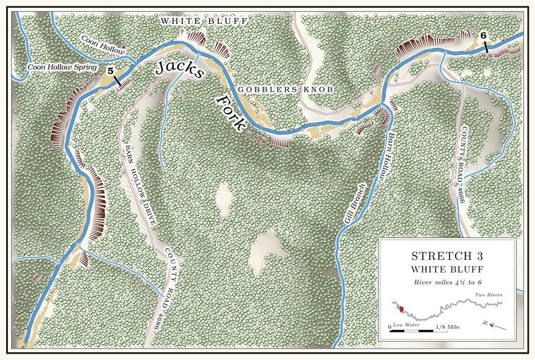
The stretch past the VFW campground ends at the Blue Hole, by one account the deepest hole on the upper Jacks Fork and the same Pool. A deep, slow stretch of river between riffles (Chapter 16). Glossary → as Gar Hole, with a spring entering on its left from a crevice in the rock. It lies at the bend a short way above Coon HollowLewis 1980, PDF pp. 14, 16 (map), the only source., at about mile 4.8Lewis 1980, PDF p. 16 (map: the Blue Hole lettered where the river turns from east to southeast, with the spring on its left bank, above the mouth of Coon Hollow), measured on the river centerline (Coon Hollow’s mouth 5.01)., where the river is shallow at Low Water. The local name for the Highway Y bridge over the South Prong, the access beside it and the county’s low-water crossing where the prongs meet, and so for the head of the river (Chapter 8; Chapter 18). Glossary → todaythe 2021–23 riverbed survey shows no pool 4 feet or deeper between about miles 4.6 and 5.2 (Heimann, Atkinson and High 2025; Map 12).. Other memories put the names elsewhere. One woman wrote “Gar Hole near Y highway” among words an outsider might not know, though she was not sure where the hole wasJacks Fork Oral History, record SV-03 (she gave the name among local words, had heard of the hole but was not sure where it was, and did not mark it on a map); see Chapter 18. (Chapter 18). A resident who came to Mountain View from Oklahoma in 1979Jacks Fork Oral History, record SV-05 (marked on a map); see Chapter 18 and Reach D. marked a Blue Hole a little below Highway 17 and a Gar Hole near the mouth of Belew Hollow (Reach D). How the two names drifted is told in Chapter 18.
Coon Hollow and Coon Hollow Spring
Hollow and spring · left bank · about mile 5.1 · Plate A3
A good spring enters the river above the mouth of Coon Hollow, which comes in from the north, draining nearly six square miles. Its lower miles may stop runningJacks Fork Creek Network 2026 (5.87 square miles); MDC 2001, PDF 90–91. in dry weather. The hollow is rough, rocky and snaky. About half a mile up it is Coon Hollow Spring, a large spring with pools deeper than a person’s head, whose water sinks into the gravelLewis 1980, PDF p. 20. before it reaches the river. The hollow is said to take its name from a renegade band of Shawnee, the Coon KlanLewis 1980, PDF pp. 16 (map, “Shawnee Camp”), 20, the only source., who camped a short way above the spring and made trouble for the early settlers. The Shawnee on the Jacks Fork are the subject of Chapter 4.
White Bluff and Gobblers Knob
Bluff and hill · left bank · about mile 5.3 · Plate A3
Below Coon Hollow the river runs along White Bluff, with a small, noisy spring at its upper end. The Bluff. A cliff along the river, usually on the outside of a bend, where the river has cut sideways into the hill. In this sense the word was first used in North America (Chapter 2; Chapter 18). Glossary → stands about 170 feetthe left-bank faces at about miles 5.18 to 5.26, measured on the flood-mapping terrain (Heimann, Atkinson and High 2025; Map 13). above the water, and Gobblers Knob rises above it. A small rock overhang on the Knob. The old Missouri name for a hill of hard volcanic rock, such as those near Eminence and the mouth (Chapter 1). Glossary → carries a buried-treasure story: in the years when Spain owned Louisiana, the story goes, a party carrying silver from Potosi to Santa Fe ran into trouble with the Osage and buried the money on Gobblers Knob. Other treasure storiessee Chapter 13. of the river are in Chapter 13.
Ratliff Ford
Ford and cabins · about mile 5.5 · Plate A3
Ratliff Ford, also called Morley FordLewis 1980, PDF pp. 16 (map, “Morley (Ratliff) Ford”), 20., is the old Radcliff Ford. A place where a road crosses through the water. Many of the river’s fords took the names of the families who lived beside them (Chapter 8). Glossary →, the crossing nearest Mountain Viewsee Chapters 8 and 18. in the 1920s. Its land deal of 1928 and the drift of its spelling from Radcliff to Ratcliff, Ratliff and Rat Cliff are told in Chapter 8, and the names in Chapter 18. County Road 4666Plate A3. comes down to the river at the bend here.
A camp for girls from the Kansas City area is said to have stood on the right bank near the ford until the late 1920s, with a footbridge across the river; pilings of the bridge could still be seen in the Chute. A narrow, fast slot of water through a shoal or past an obstacle. A smooth V of water pointing downstream marks the deepest path through it (Chapter 20). Glossary → below in 1980. A spring enters on the right above the pilings. On the hillside on the right bank near the ford the Mountain View Health and Recreation Club kept several old cabins around 1980, privately owned and runLewis 1980, PDF pp. 16 (map), 20, the only source., probably those of the outing club that Mountain View business and professional men organized at the ford in 1928an inference; see Chapter 9. (Chapter 9). A Howell County columnist’s family, when not camping at Alley, swam at the fordWhitaker 2025 (“unless my family was camping at Alley Springs, our favorite swimming hole was upstream from the Highway 17 bridge at Ratliff Ford”); see Chapter 19. (Chapter 19). From 1991 to 1998 state biologists sampled a stretch of river at the ford every year for crayfishDiStefano and others 2003, 346–349; see Chapter 16. (Chapter 16).
Barn Hollow and Barn Hollow Natural Area
Hollow and natural area · right bank · about mile 5.7 · Plate A3
Barn Hollow is the largest side valley in the reach. It drains about fourteen square miles and runs about nine miles from its head in northern Howell CountyJacks Fork Creek Network 2026 (14.22 square miles; 14.7 kilometers); Pottenger 1945, Howell file p. 4. to the river in Texas County, and for most of its length it may stop runningMDC 2001, PDF 90–91. in dry weather. Near its lower end the creek has cut a canyon through Dolomite. Calcium magnesium carbonate rock, a close relative of limestone, formed from lime mud on the floor of a warm, shallow sea. Nearly every bluff on the Jacks Fork is dolomite (Chapter 1). Glossary →, with vertical bluffs up to a hundred feet high, a deeply entrenched and meandering course, and a clear stream of small deep pools, short Riffle. A fast, shallow, rocky stretch between pools. The riffles are the gardens of the riverbed: in July a square meter of riffle produced more than six times as much as a square meter of pool (Chapter 16). Glossary → and beaver ponds. Forked aster, a plant of the north, grows along it. Julian Steyermark, who later wrote the standard flora of the stateSteyermark 1963., worked the canyon on August 17 and 18, 1934, and again in May 1935, and took showy lady’s-slipper from the moist bluffs at its foot and American barberry from the edge of a precipice along the river between the hollow and Highway 17University of Missouri Herbarium, Columbia, specimens 1615102 (Cypripedium reginae, August 17, 1934, “moist limestone bluffs at base of canyon, ‘Barn Hollow’ Canyon”), 1659156 (August 18, 1934), 1565255 (Berberis canadensis, May 25, 1935, “edge of limestone precipice along bluffs of Jack’s Fork of Current River, between Barn Hollow Canyon and Hwy 17”) and 1682181 (May 26, 1935).. Louisiana waterthrushes live along the water, eastern phoebes nest on the bluffs, and the ringed salamander, found only in the Ozarks, lives there along with slimy and cave salamanders, southern leopard and pickerel frogs and Blanchard’s cricket frogs (Chapter 16). The ringed salamander spends most of the year underground in the woods. On rainy nights in autumn, mostly in September and October, the adults travel to fishless Woodland. The period of prehistory from about 600 B.C. to A.D. 900 in radiocarbon years, when people here first made pottery and took up the bow (Chapter 3). Glossary → ponds to lay their eggs, and the larvae stay in the water through the winter, six to eight months or moreMDC, “Ringed Salamander.”, before they change and leave. The Conservation Department’s land at the hollow holds two small fishless ponds, about an acre of waterMDC 2016 (Barn Hollow), area summary (fishless pond, 1 acre, in two ponds). between them. Small caves and dolomite boulders line the valley slopes.
Barn Hollow Natural Area protects 190 acres of the canyon. It was designated on May 27, 1980, the same day as the Jacks Fork Natural AreaMDC, Jacks Fork Natural Area; see Chapters 11 and 16. downstream, and the Conservation Department and the Park Service own it together (Chapter 11). The Conservation Department bought its land in the hollow in 1979. It named 115 acres a Natural area. A Missouri tract set aside as one of the best remaining examples of the state’s native communities, to be managed to keep it that way. The Jacks Fork and Barn Hollow natural areas were designated on May 27, 1980 (Chapter 11). Glossary → the next year and added 30 more in 2007, and the Park Service owns the 45 acres beside themMDC 2016 (Barn Hollow), area history.. A half-mile trail leads to an overlook above the hollow. The land directly north of it, now the Conservation Department’s, was the farmstead where Sue Hubbell kept bees and wrote A Country YearMDC, Barn Hollow Natural Area.: Living the Questions (1986). She came there in 1972 with her first husband, to a farm of ninety acres. After the marriage ended in the early 1980s she was left with about 300 hives and a struggling honey business, which she kept going by writing for the St. Louis Post-Dispatch and then the New York Times. She died in Maine in 2018Bangor Daily News 2018..
Gill Branch, lettered on Plate A3, flows into Barn Hollow and carries the name of Samuel K. Gill, a Union private who settled there about 1872Pottenger 1945, Howell file p. 40.. The hollow was also called Winningham Hollow, for Isaac Winningham, who homesteaded 160 acres there in 1869. Its own name comes either from a farm of the Civil War years with several log barns or from “barren”Pottenger 1945, Howell file p. 4; see Chapter 18. (Chapter 18). The history of its spring and its schoolsee Chapters 5 and 18. is in Chapters 5 and 18. Bear Cave, one of the larger caves of the upper river, and Bat Cave are in the Barn Hollow country (Chapter 13).