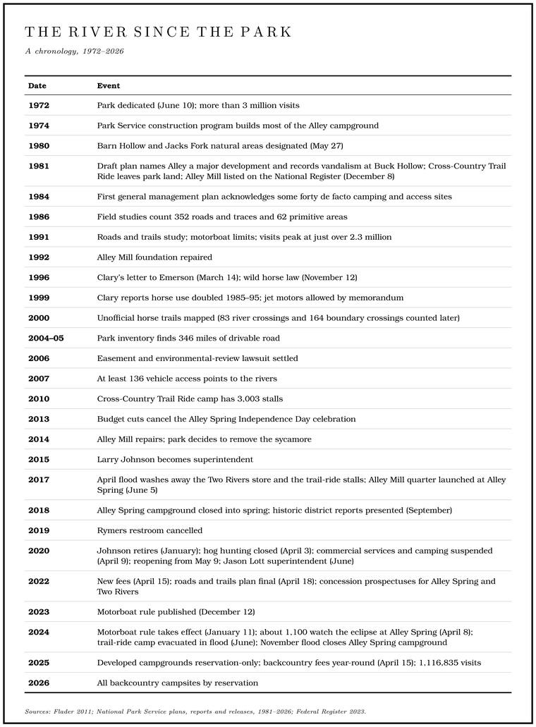
The Ozark National Scenic Riverways was dedicated at Big Spring on June 10, 1972see Chapter 10., when Tricia Nixon Cox, the President’s daughter, cut the ribbonNPS, “Park Establishment History” (the ceremony at Big Spring “presided over by Patricia Nixon Cox who cut the ribbon”); NPS 2014 (fiftieth anniversary), photograph caption (“Tricia Nixon Cox, the President’s daughter, dedicating the park”)., and that year the Park Service counted more than three million visits, the highest figureNPS 2014 (GMP), 207. it reports for any year. Its first officials had few models to follow. Until Cape Cod National Seashore in 1961, most national parks had been made from public land or from land given to the government, and the Riverways was among the first to be put together by buying it, tract by tract, from the people who lived on it. During George Hartzog’s years as director the park system took on some seventy new units, experienced administrators were scarce, and the public came to the newly designated riverways before the Park Service was ready to receive it. Local Outfitter. A business that rents boats to floaters and runs their shuttles (Chapter 20). Glossary → bought more canoes to meet the demand and probably came to carry more weightFlader 2011, 117 (officials “necessarily learning on the job”; outfitters “exercised disproportionate influence on local NPS officials”), the only source for the judgment. with the park’s officials than their numbers warranted.
The park went through its first superintendents quickly. Vernon Hennesay, chief ranger in 1965, was the second, in 1966–67Hennesay 1998, preface., and David Thompson followed in 1967–70, while the land office at Eminence did the buyingThompson 1998, preface. (Chapter 10). Arthur Sullivan came in August 1976 and stayed until he retired in January 1995. Before he arrived he was warned that hostility from the land buying and the Condemnation. The taking of private land for public use by court order, with payment at fair market value. Some land for the Riverways was taken this way in trials from 1967 to 1970 (Chapter 10). Glossary → still lingered there, and in his view hard feeling of that kind could last for generationsSullivan 1998, 6–7, 14–15 (“I had been forewarned that there were certain hostilities lingering there because of land acquisition and condemnation”; such acquisition “creates hard feelings that could last for generations”)..
On the Jacks Fork the park took the shape it still has. From the Prongs to the long bends about 4.2 miles below them, nearly three miles above Buck Hollow, the river runs through private land outside the boundary. From there to Two Rivers it is federal, broken at Eminence by the town’s gapsee Chapter 10 and Reach C. (Chapter 10). Park headquarters are at Van BurenNPS 2022a, 74. on the Current, and the Jacks Fork is run as one of the park’s districts from Alley SpringNPS 2021, 41; NPS 2022 (concessions)..
Campgrounds a day’s float apart
The park was laid out for floaters. Its first planners put visitor areas, each with a river access, a campground or other facilities, a day’s float apart, thirteen of them at first and nineteenFlader 2011, 117. by 2011, so that a party could put in at oneinference from the spacing. in the morning and camp at the next by evening. In 1981 Alley Spring ranked among the park’s major developments, Two Rivers, Buck Hollow and Blue Spring with Bluff View among its minor ones, and there were more than Forty. Forty acres, a quarter of a quarter section. A hill farm was often one or two forties (Chapter 5). Glossary → primitive sitesNPS 1981, 18. across the park besides.
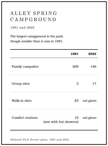
Alley came to the park as a state park that Civilian Conservation Corps crews had partly developed in the 1930s (Chapter 9). The Park Service enlarged it. A major portion of the campground was built in the agency’s construction program of 1974, and by 1981 it had 209 family campsites, 23 walk-in sites, three group sites and ten comfort stations, one of them with hot showers. Three CCC houses served as staff quarters, the old park office as a ranger station, and the horse and carriage shed as a maintenance shop. Among the seasonal rangers at Alley in the 1970s was Tom AkersNASA, Akers (summer park ranger at Alley Spring, 1972–76). of Eminence, later an astronaut (Chapter 18). A concessioner ran a laundry, showers, firewood sales and a gift shop inside the mill, and the plan proposed moving the shop to a new campground store and enlarging the amphitheater to two hundred seatsNPS 1981, 81..
The planners counted Alley’s interpretive program a success. It rested on three features: the Roller mill. A mill that grinds grain between steel rollers. Alley Mill, finished in 1894, is one (Reach H). Glossary →, the Storys Creek school and a whiskey-making demonstrationNPS 1981, 85.. The mill had been nominatedNPS 1981, 81. to the National Register of Historic Places, the federal listgeneral. of buildings and sites judged worth preserving, and it was listed on December 8, 1981NRHP, Alley Spring Roller Mill 1981.. It still ground in those yearsOzark Riverways 1976, PDF pp. 21–24 (the Eminence calendar).. A Mountain View magazine’s calendar for 1976 sent visitors to the “Old Red Mill at the Alley Springs Park,” with “a museum and an operating grist mill,” and the park sold the corn flourSullivan 1998, 29–30 (he names the “Red Mill,” then confirms “That was at Alley Mill”). ground there until, as its superintendent put it, “our own U.S. public health inspectors got after us.”
By the Highway 106 bridge the park had inherited a commercial strip. Harvey’s, with its canoe Concession. A business under contract with the Park Service to serve visitors inside the park, such as the canoe rentals at Alley Spring and Two Rivers. The canoe-rental permits became concessions in 1973 (Chapter 10; Chapter 11). Glossary →, restaurant, store and motel (Chapter 9), operated under a Term estate. A right of private use that ran for a fixed term after the government bought the land, as Harvey’s at Alley held (Chapter 11). Glossary →, and in 1981 the whole operation was to be torn downNPS 1981, 81; see Chapter 9. when the term ran out. Lynne Norris of Winona, who swam at Alley in the 1970s, remembered “the roller rink and the trampolines”Jacks Fork Oral History, record SV-17. near the access. Nobody has yet established when the term estate ended or when the buildings came down. The name outlasted the strip: Harvey’s Alley Springs Canoe Rental still operates near Alley, one of the two main outfittersHarvey’s Alley Springs Canoe Rental (the business’s own account of itself, 2026). on the lower river along with the rental at the Eminence bridge. A huge Gravel bar. A bank of chert gravel and sand, usually on the inside of a bend, bare at low water (Chapter 15; Chapter 18). Glossary → beside the bridge served as a beach and a launching place. The paved boat ramp nearby had become useless because the river kept dropping gravel at its foot, and the planners decided to let the ramp fill inNPS 1981, 81–82. and send boaters to the bar (Chapter 15).
At the park’s uppermost access on the Jacks Fork, Buck Hollow fared worse. The Highway 17 bridge had long been a Put-in, take-out. The places where a float begins and ends (Chapter 20). Glossary → (Chapters 8 and 9), and in 1981 it offered only primitive camping, a primitive river access and random parking. There had been no new development there “because of reoccurring major vandalism problems.” The vault toilet had needed constant repair, and vandals had burned it. Most of the signs had been “shot up, pulled out, stolen, or destroyed,” signs put up with the state highway department’s help had made little difference, and dumped trashNPS 1981, 86. was a growing problem for the maintenance crews. The plan listed improvements all the same, among them a vault toilet, a canoe landing, a defined primitive camping area and better parkingNPS 1981, 116 (development priority 19).. Forty years later Buck Hollow was a popular access, close as it is to Mountain View, with a new restroom by the pull-offNPS 2021, 117 (popular “due to its proximity to Mountain View”). from Highway 17 that floaters and passing drivers both use.
At the mouth, Two Rivers in 1981 had a campground, a concession store and the old ferry landing, used by canoeists and johnboatersNPS 1981, 79. alike. Shawnee Creek, between Eminence and the mouth, became a backcountry campground of six to eight sites with an equestrian staging area for a seven-mile loopNPS 2021, 187. trail. Upstream of Alley the park’s backcountry campgrounds include Bay Creek, Rymers and Blue Spring, where Bachers and Baptizing HoleNPS 2022b; NPS 2022a, appendix E. are counted as part of Blue Spring.
Alley remains the hub. Its general store is the visitor contact station and the park’s main point of sale, the Jacks Fork district’s headquarters and interpretive staff work from Alley, and the campground is the largestNPS 2021, 41. in the park. It is smaller than it was in 1981: 146 family sites and seventeen group sitesNPS 2022a, C-14. in 2022. On a busy day up to 366 people may be in the Alley Spring area at once, not counting campers, and the park has set the capacity of the Alley trails at 400 peopleNPS 2022a, C-15. at one time.
Roads to the gravel bars
The park’s developed campgrounds were set back from the river and screened from it. Many local families wanted something else. They had been coming to the river for generations, and they wanted their own spot, right on the waterFlader 2011, 118 (“Local Ozark families have been visiting the river for generations, and they want to be in their own spot, right on the river, not in a developed campground with others”). and away from the developed campgrounds and other campers. Their spots were gravel bars and riverside flats at the ends of old roads and traces, and the 1984 management plan acknowledged some forty of them as de facto camping and access sitesFlader 2011, 117, citing the 1984 plan., places used for camping and access though never designated for it. At such sites campers did much as they liked. They cut and mowed the brush and reshaped the banks to open the view and ease the way to the water, and the roads that reached them appeared on no park map for visitors, so that they served mainly people who knew the way and drove a truck or an all-terrain vehicleFlader 2011, 118 (“in the unofficial primitive sites anything goes, including slashing and mowing vegetation and reshaping banks”; the roads “are not shown on any ONSR maps for general visitor use”). heavy enough for the ruts.
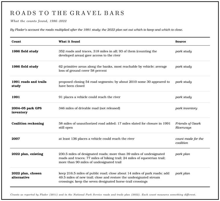
Field studies in 1986 measured the problem. One counted 352 roads and traces inside the park, 318 miles in all, of which 93, counting the developed areas, gave access to the river. How many of them were older than the park has not been determined. The other study found sixty-two “primitive areas” along the banks, most of them reachable by vehicle, which had lost on average 58 percentFlader 2011, 118, citing Mendiola 1986. of their ground cover. Bare ground at a river’s edge is easily carried off by the next rise, and a set of ruts on a slope gathers rain and carries it down as a small creek, which cuts the ruts deepergeneral; see Chapter 8. each year, as the old wagon roads gullied (Chapter 8).
The roads and trails study that followed in 1991 left the county roads alone and proposed closing only fifty-four other road segments, those that threatened rare species, were damaging the ground, were unsafe or duplicated other access. It was probably too slight for the jobFlader 2011, 121, who thought the study weak.. Its environmental assessment, the short review federal law requiresthe environmental assessment under the National Environmental Policy Act (general). to judge whether an action needs a full environmental statement, ran to less than four pages, and it weighed the effects of closures on the people who drove the roadsFlader 2011, 118 (a “short (less than 4-page!) environmental assessment”). while leaving out the far larger number who floated past them. By about 2010 some thirty of the fifty-fourFlader 2011, 120. appeared to have been closed.
The roads multiplied in the years that followed. By one account county crews bulldozed new roads to the river, knowing nobody would challenge them, and the use of all-terrain vehiclesFlader 2011, 120 (“County road crews brazenly bulldozed new roads to the river, knowing they would not be challenged”), the only source. spread. In 2004 and 2005 the park made its own inventory with GPS and found 346 miles of drivable road. The results were not released. Comparing them with the earlier inventory, Friends of Ozark Riverways, a coalition of conservation groups, reckoned that fifty-eight miles of unauthorized road had been added and that seventeenFlader 2011, 120–21. miles slated for closure in 1991 were still open. Where the 1991 study had mapped 91 places a vehicle could reach the river, a count made for the coalition found at least 136 by 2007. The coalition’s report described the view from a canoe:
There is almost nowhere that a floater can land on a gravel bar and walk into the woods without being assaulted by a maze of rutted, heavily eroded roads, scarred or dead trees, and degraded habitat, not to mention the frequent sights from the river of vehicles and their tire tracks on gravel bars and river banks.
Behind the roads lay a standing quarrel over who the park was for. The Missouri Coalition for the Environment sued the Park Service over violations of Scenic easement. A right bought by the government that leaves an owner the land, the house and the right to farm and gives up the right to develop. The law of 1964 used them along the Riverways (Chapter 10). Glossary → and its failures to follow federal environmental review, and in a settlement in 2006 the agency agreed to follow those requirements on future projects. When the park asked for comments on a new management plan in 2009, it received thousands, reportedly more than any recent park question but the Yellowstone winter-use fight, split about evenlyFlader 2011, 120 (“reportedly more than on any recent issue except the Yellowstone winter use controversy”). between those, mostly from around the park, who wanted no further regulation and those who wanted much stronger protection. One reading of the situation is that management had “gone local”: new officials saw the problems when they arrived and soon found it easier, and perhaps saferFlader 2011, 124–25 (“a classic case of park management ‘going local.’ New NPS officials assigned to the park recognize the problems when they first arrive, but soon realize that it is easier—perhaps even safer—to give in to vocal local demands”)., to give in to the loudest local demands.
The roads and trails plan that the 2015 management plan called for was released in final form on April 18, 2022NPS 2022c. (Chapter 10). By then the park counted 230.5 miles of designated roads, more than 39 miles of undesignated roads and traces made by visitors, 77 miles of hiking trail, 24 miles of equestrian trail and more than 90 milesNPS 2022a, 3–4. of undesignated trail worn since 1991, most of it by horses. The alternative the Park Service choseNPS 2022c. would keep 216.5 miles of public road, close about 14 miles of park roads, add 49.5NPS 2022a, 13–14. miles of new trail and close and restore the undesignated stream crossings, while keeping the seven designated horse-trail crossingsNPS 2022a, 15. of the rivers. Superintendent Jason Lott said the park could now “move forward to establish a network of roads and trails that is more sustainable and clearly mapped.”
The trail rides
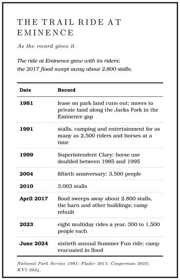
Much of the horse use centered on the lower Jacks ForkNPS 2022a, 77–79.. In its early years the Cross-Country Trail Ride at Eminence held three rides a year and drew a couple of hundredCooperman 2023. people. It camped on park land until its lease ran out in 1981see Chapter 10. (Chapter 10), then moved to private landFlader 2011, 119, quoting the 1991 study (“horse use is permitted on all unpaved roads and traces within the park except where posted”). along the Jacks Fork in the Eminence gap and kept growing. By 1998, by its owner’s account, its old grounds had become a park horse camp, grown up and hard to reachSmith 1998, 16.. Tom Akers (Chapter 18) later rode as one of its trail bosses for more than twenty yearsKennedy Space Center 2026.. When the park reviewed its horse trails in 1991, its only designated trails, fourteen miles of them, all lay near the mouth of the Jacks Fork, where the Trail ride. An organized gathering of hundreds or thousands of horseback riders, camping for several days and riding the trails and river crossings. The trail rides grew into a large business on the lower Jacks Fork (Chapter 11). Glossary → offered stalls, camping and entertainment to as many as 2,500 riders and horses at a time. Horse use was then permitted, in the park’s own words, “on all unpaved roads and traces within the park except where posted.”
Ben Clary, superintendent from the mid-1990s, tried to change that. The minutes of a staff meeting in 1996 record that “the biggest issue discussed” was the use of undesignated horse trails, and that federal regulations “specifically”Flader 2011, 122–23, quoting NPS staff meeting minutes, 1996. prohibited horse use outside designated trails. His complaint went wider than horses. In March 1996 he wrote to Congressman Bill Emerson:
We have withdrawn from the rivers, our primary resource and purpose for the park. We have withdrawn from preserving and interpreting the Ozarks cultural heritage which is so important to the area. . . . Perhaps we need to re-evaluate where we are headed. Are we in fact Ozark National Scenic Riverways or Ozark National Scenic Campgrounds?
In 1999 Clary told a meeting of riders that horse use in the park had doubled between 1985 and 1995, and he asked them to help map the trails. By April 2000 four large maps showed every stretch of unofficial trail, and when they were later digitized for Friends of Ozark Riverways they showed 83 places where the trails crossed a river and 164 where they crossed the park boundary. A team of one park staff member and nineteen riders then drew up two plans, one of them for 259 miles of designated loop trails with twenty-five staging areas. The effort was apparently dropped. Clary retired and his successor died within a year, though whether that was why has not been established. The only limits the park went on to set were apparently on group size, in the permits for the four big ridesFlader 2011, 123, the only source. the Cross-Country Trail Ride held each year. The ride’s owner said in 1998 that he now routed riders away from the river crossings, and by his reckoning that had cut the crossings by half or moreSmith 1998, 17, his own estimate..
The park’s counts show where the riders went. Over ten days in October 2015 counters at several sites tallied 3,688 riders, 987 of them at Shawnee Creek and 347NPS 2022a, 77, C-29. at Alley Spring. Between October 2015 and October 2016 the park estimated 8,858 horseback riders, 96 percentNPS 2022a, 78–79. of them around Alley Spring, Shawnee Creek and Two Rivers, and Alley ranked third in the parkNPS 2022a, C-14. for horse use. By 2022 the park held commercial authorizations for two trail-ride businesses, the Cross-Country ride at Eminence and Big Creek Trail Rides at Hartshorn, whose events of up to 2,500 riders came about eighteen times a yearNPS 2022a, 28. between April and October.
The ride at Eminence grew with its riders. Its fiftieth anniversary in 2004 brought 3,500Cooperman 2023. people, and by 2010 its camp had 3,003 stallsFlader 2011, 122. for horses. The flood of April 2017 swept away about 2,800 stalls, the barn and other buildings, thirty years of work, and the camp was rebuilt. By 2023 the ride held eight multiday rides a year, each drawing 300 to 1,500 people, with a band for the nightly dances and a Sunday church serviceCooperman 2023. to open each ride. In June 2024KY3 2024. the Jacks Fork rose during the sixtieth annual Summer Fun ride and the camp had to be evacuated, and Eminence’s fire chief described “people trapped on little islands.”
The herd since 1996
The law of 1996 kept the wild horses in the park (Chapter 10), with a herd of no more than fifty, and directed the Park Service to manage them by agreement with the Missouri Wild Horse LeaguePublic Law 104-333 (16 U.S.C. § 460m-6).. The League looks after them, providing veterinary care, health monitoringNPS 2024 (wild horses)., upkeep of the fields and an adoption program, and the park takes what it calls a “hands-off approach when possible.” The herd grows from year to year, and when it passes fifty, League members gather some of the younger horses and offer them for adoption across the countryAssociated Press 2016; Curtis 2021..
By 2021 the horses ran in four herds, Shawnee Creek, Broadfoot, Round Spring and Rocky Creek. The Shawnee Creek herd ranges along the lower Jacks Fork and is often seen in a pasture east of EminenceCurtis 2021 (the photographer Dean Curtis, who published a book about the horses in 2022), the only source for the four herds; KSMU 2022. toward Two Rivers. Visitors at the Shawnee Creek campground often meet itNPS 2021, 187., and the horses there tend to approach peopleKSMU 2022..
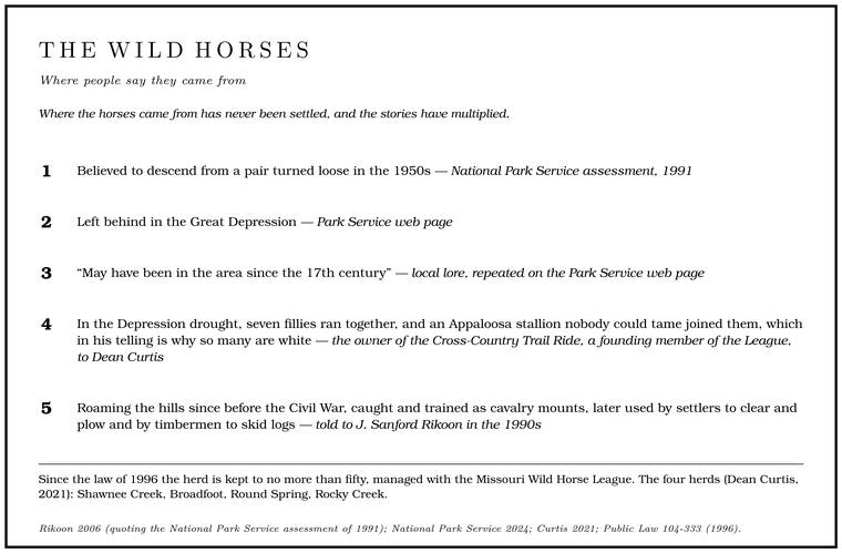
Where the horses came from has never been settled, and the stories have multiplied. In 1991 the Park Service believed the herd to descend from a pair turned loose in the 1950sRikoon 2006, PDF 4, quoting the Park Service’s 1991 environmental assessment; see Chapter 10. (Chapter 10). The agency now calls the origin unknownNPS 2024 (wild horses). and repeats two other accounts, that the horses were left behind in the Great Depression and, from local lore, that they “may have been in the area since the 17th century.” The owner of the Cross-Country Trail Ride, a founding member of the League, has told a Depression version. In the drought, the story goes, farmers who could no longer feed their horses turned them loose, seven fillies ran together, and an Appaloosa stallion nobody could tame escaped and joined them, which in his telling is why so many of the horses are whiteCurtis 2021, the only source.. In 1998 the ride’s owner said that the horses had been there all his life and that his grandmother had seen them near Two Rivers when she was a girl. Stock that families had run out on the Open range. The old rule that a farmer fenced his crops in and let his animals run on all unfenced land; also called free range. Shannon County kept it the longest in Missouri, until a state law of 1969 (Chapter 5). Glossary → and never came back for after the Depression joined them, and he put the herd then at a little over thirty head, with seven studsSmith 1998, 8–9 (“about a little over thirty”; “seven studs”), his own count.. An older story, told to a visiting sociologist in the 1990s, held that wild horses had roamed the hills since before the Civil War, when they were caught and trained as cavalry mounts, and that settlers later used them to clear and plow and timbermen to skid logsRikoon 2006, PDF 8 (told to J. Sanford Rikoon), the only source..
The people who watched the horses knew them one by one. A local man described one band in the 1990s: two white mares, thirteen or fourteen years old, that he had known since they were colts; a gray mare; a white mare with a crooked neck; three roanish grays; and two colts, one blaze-facedRikoon 2006, PDF 7. and turning white. In 2016 the League’s vice president, then eightyAssociated Press 2016., said that “there’s always been horses in the woods that nobody owned.”
Rules, fees and reservations
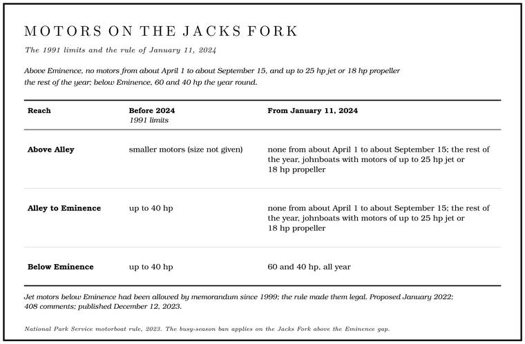
The management plan approved in 2015 (Chapter 10) took years to turn into rules. The motorboat limits came first. The Park Service proposed them in January 2022, received 408 comments and published the final rule on December 12, 2023, to take effect on January 11, 2024. It replaced limits set in 1991, which had allowed outboards of up to 40 horsepower on the middle reaches of the two rivers, on the Jacks Fork below Alley36 C.F.R. § 7.83(a), text in force before 2024., and smaller ones above. In Sullivan’s years the park had already proposed that no motors run on the upper Jacks Fork during the bass seasonSullivan 1998, 27 (“On the upper Jacks Fork … during the bass season we also proposed there would be no motors involved”; the compromise became a limit of five or ten horsepower).. On the Jacks Fork above the Eminence gap, motors are now barred in the busy season, from the day after the spring trapping season closes, about April 1, until the season for Gig, gigging. A gig is a spear of three or four barbed iron tines on a pole as much as fourteen feet long. Gigging is spearing fish with it from a boat in clear, shallow water, chiefly suckers, by night under lights or by day (Chapter 19). Glossary → nongame fish opens, about September 15. The rest of the year Johnboat. A long, narrow, flat-bottomed, square-ended boat, poled, paddled or motored. It was the guide boat of the Eminence outfitters and is still the fishing and gigging boat of the river. The word is in print from 1894 (Chapter 9; Chapter 18). Glossary → may run there with motors of up to 25 horsepower for Jet unit. A boat motor with no propeller below the hull. An impeller inside its housing draws water in through a grate and drives it out astern, so the boat can run riffles only inches deep (Chapter 19). Glossary → or 18 for propellers. A jet unit Draw. A valley, in the usage of the Eleven Point side of the divide in Howell County (Chapter 18). Glossary → water in through a grate in the Bottom. The flat land along a river or creek, built of its deposits and open to its floods. In the 1920s the bottoms near Eminence averaged about a quarter of a mile wide (Chapter 2; Chapter 5). Glossary → of the motor and drives it out astern through a nozzle, so nothing hangs below the hull to strike the rocks of a shallow Riffle. A fast, shallow, rocky stretch between pools. The riffles are the gardens of the riverbed: in July a square meter of riffle produced more than six times as much as a square meter of pool (Chapter 16). Glossary →, and because the pump loses part of the engine’s power, a jet is allowed a larger enginehow an outboard jet drive works (general); the rule sets the higher jet limit for that reason (88 Fed. Reg. 86050). than a propeller. Below Eminence the limit is 60 and 40 horsepower the year round, which made legal the jet motors that superintendents had allowed by memorandum since 1999. Among its reasons the agency listed keeping motor access for gigging and trapping, citing the strong cultural ties88 Fed. Reg. 86050 (2023); NPS 2023 (horsepower). to both on the upper rivers. The details are in Part Six.
Fees rose too. From April 15, 2022, a Backcountry campsite. One of the park’s designated camping places along the river away from the developed campgrounds. On the Jacks Fork they are at Blue Spring, Baptizing Hole, Bachers, Rymers, Bay Creek and Shawnee Creek (Chapter 11; Part Six). Glossary → cost $10 a night in season instead of $5, and a non-electric site in a developed campground such as Alley or Two Rivers cost $20 instead of $16, and the developed campgrounds began charging in the off-season as well. The sites at Bachers and Baptizing Hole were brought under the fee for Blue Spring. Forty-three comments came in, and the park reduced the backcountry increase in response. Under the federal recreation fee law the park keeps about 96 percentNPS 2022b. of what it collects.
Reservations followed. In 2025 the developed campgrounds, Alley Spring and Two Rivers among them, became reservation-only, and backcountry sites, still first come, first served, were to be paid for through the federal recreation reservation service from April 15. By 2026 every backcountry campsite had to be reserved through that federal service and paid for the year roundNPS 2026 (backcountry).. Camping at established primitive sites remains freeNPS 2025 (campgrounds). (Part Six).
Canoe renting stayed with concessioners. In 2022 the park managed eighteen concession contractsNPS 2022a, 77., and that April it offered new ten-year contracts for the two on the Jacks Fork, Alley Spring Canoe Rental and Two Rivers Canoe Rental, each to rent canoes and tubes, run Shuttle. The trip that brings vehicles from the put-in to the take-out, so floaters can get back (Chapter 20). Glossary →, keep a camp store and sell firewoodNPS 2022 (concessions)..
Some rules answered new problems. Feral hogs had spread into the Ozarks, rooting up fields, springs and historic sites. Wild hogs live in family groups, and the trappers’ method is to bait a large corral trap until a whole group comes in and then close it on all of them at once. A hunter who shoots or chases one or two hogs scatters the restNPS 2020 (feral swine)., and the survivors grow warygeneral (whole-group trapping of feral swine). of traps. In April 2020 the park closed its land to hog hunting for that reason, except by hunters carrying a deer or turkey permit.
Closed for a season
The park has been shut for weeks at a time more than once. In the spring of 2020, as the coronavirus spread, it cut back operations in March, and on April 9 it suspended all commercial services, the canoe rentals among them, and closed all camping. It began to reopen on May 9, with the campgrounds to follow on May 22 and the pavilions on June 5. Large crowds followed. By late July the campgrounds had been full on Friday and Saturday nights several times that summer, and the park said visits had risen at places like Alley MillNPS 2020 (COVID-19)..
Floods closed it more often (Chapter 14). The flood of April 2017 washed away the store at Two Rivers, and the next year Two Rivers Canoe Rental was working from a mobile office near where the store had stood. At Alley the campground’s water line crossed the river on the damaged footbridge (Chapter 8), and the campground stayed closed into the spring of 2018 for fear the line would freeze. The restroom at Shawnee Creek was to be replaced with a concrete vault toilet built for ground that floods, and the vehicle bridge over Alley Spring BranchNPS 2018 (flood recovery). was scheduled for replacement. The new bridge, on the North River Road, was under way in the spring of 2019 and expected to open that summerNPS 2019 (river reopened).. Superintendent Larry Johnson, who led the response, said the disaster had given the park a chance to reset and build flood-resistantNPS 2019 (Johnson). structures. A new restroom for Rymers was cancelled in 2019 because heavy equipmentNPS 2019 (Rymers). could not be brought to the site. In 2022 Rymers and Bay Creek were on the list again, among seven sites to receive flood-resistant vault toilets of precast concreteNPS 2022b; NPS 2022 (restrooms).. In November 2024 the upper Current broke its records, the Jacks Fork ran high without breaking its own, and Alley Spring campground was expected to stay closed for several weeksNPS 2024 (flood). for cleaning and repairs.
Counting the visitors
The park’s visitor figures do not always agree. Visits are given as peaking at more than three million in 1972, settling at around 1.5 million a year from the mid-1970s and peaking again at just over 2.3 million in 1991. Another series of agency figures puts total visits at nearly two million in 1979 and a fall to about 1.3 million by the 2000s, as many canoeists stopped coming and others brought back reports of drunken crowds and of horses and all-terrain vehiclesFlader 2011, 117, 120. in the river. The park counts as a visitor anyone who enters it or uses its facilities for any reason, and some of the people counted only pass throughNPS 2014 (GMP), 207. on the roads.
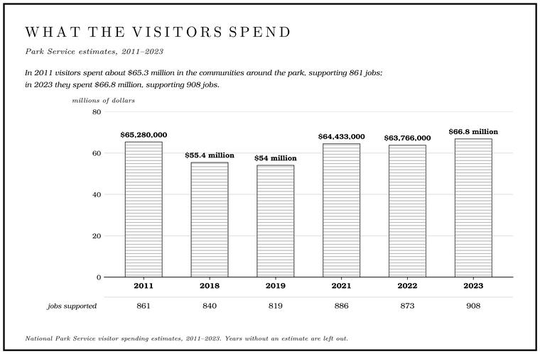
The agency also puts a dollar value on the visitors (Table 11.1). It multiplies the number of visits by what different kinds of visitors have been found to spend on lodging, food, gas, rentals and the like, and then estimates how much of that money goes round againthe Park Service’s visitor spending effects method (general). in the local economy as businesses buy supplies and pay wages. In 2011, 1,365,960 visitors spent about $65.3 million in the communities around the park, supporting 861 jobs. In 2023 about 1.3 million visitors spent $66.8 million, supporting 908 jobs, and the agency put the total benefit to the local economy at $76.8 million.
Budgets set limits of their own. Federal spending cuts in 2013 took $326,681NPS 2013 (budget). from the park. Evening programs were dropped at Round Spring and Pulltite, the Round Spring Cave tours were not offered, restroom cleaning was cut back at the smaller campgrounds, and the Independence DayNPS 2013 (budget cuts made). celebration at Alley Spring was cancelled.
| Year | Recreation visits | Visitor spending | Jobs supported | Total benefit to local economy |
|---|---|---|---|---|
| 1972 | more than 3 million | |||
| mid-1970s on | about 1.5 million in most years | |||
| 1979 | nearly 2 million (another agency series) | |||
| 1991 | just over 2.3 million | |||
| 2011 | 1,365,960 | $65,280,000 | 861 | |
| 2012 | about 1.4 million | about $56 million | ||
| 2018 | 1.3 million | $55.4 million | 840 | $60 million |
| 2019 | 1.2 million | $54 million | 819 | $58,601,000 |
| 2021 | 1,328,773 | $64,433,000 | 886 | $73,856,000 |
| 2022 | 1,291,305 | $63,766,000 | 873 | $73,310,000 |
| 2023 | 1.3 million | $66.8 million | 908 | $76.8 millionNPS 2024 (economy). |
Alley Mill
In January 2014 architects, historians and engineers inspected Alley Mill and found numerous restoration needs, the most urgent being water and tree roots working into its foundation. The park called the mill its top project for the year and closed it for work planned from mid-April through August: a new wood-shingle roof, drainage trenches and sheet steel to carry water away from the foundation and the turbine pit, repairs to rotted framing and a fresh coat of red paint. The park also decided to remove the big sycamore beside the mill, which appears in many visitors’ photographsNPS 2014 (Alley Mill). of it. Its roots had grown into the foundation and the turbine pit and cracked them, and a large root had entered the basement. A root that finds a crack in masonry grows thicker inside it year after year and pries the stones apart, and water that follows it in softens the mortargeneral.. The foundation had been repaired in 1992NPS 2014 (sycamore)., and the roots had broken the same place again. By June the work was ahead of schedule, and the mill was to reopen on weekends in JulyNPS 2014 (Alley Mill reopening)..
On June 5, 2017, the United States Mint launched its quarter for the Ozark National Scenic Riverways at Alley Spring, one of the series of quarters honoring a national park or other public site in every state. The reverse shows the millU.S. Mint 2017 (the America the Beautiful quarters).. A cultural landscape report and a historic structure report on the Alley Spring historic district followed, and the park presented them at an open house at the spring in September 2018NPS 2018 (Alley historic district)..
Alley has become the park’s Stage. The height of the water surface above a gauge’s datum, the reading a gauge records. A stage differs from the depth of the water. At Eminence the datum stands 616.18 feet above sea level (Chapter 14). Glossary → for the old life of the river. The Independence Day celebration recalls the picnics at the spring around 1900 (Chapter 9), with music, square dancing and free watermelon and lemonadeNPS 2016 (Independence Day)., and in October there are demonstrations of traditional skills such as broom making, soap making and moonshiningNPS 2022 (cultural skills).. In 2022NPS 2022 (Alley community). the park, the Shannon County Museum Association and the Ozark Riverways Foundation held an evening at the mill and the Storys Creek school to “rediscover the history of the Alley community.” The year before, the park invited families from Two Rivers, Shawnee Creek and Blair Creek to a reunion at Two Rivers, with gigging boatsNPS 2021 (Two Rivers). on the water at sundown. About 1,100 people watched the total eclipse of April 8, 2024, from Alley Spring, the second-largestNPS 2024 (eclipse). crowd in the park after Big Spring.
Above the park
Above the park boundarysee Chapter 10 and Reach C. the public’s share of the Jacks Fork is small. The Missouri Department of Conservation keeps the South Prong Access, 3.3 acres on Route Y six miles north of Mountain ViewMDC, South Prong Access., and where the river will float a canoe the public may float, wade and fish it within its bed, below the High-water mark. The edge of a stream bed, in practice the line where trees and other permanent plants grow. The public’s right to float, wade and fish runs to it (Part Six). Glossary →see Chapter 10 and Part Six (MDC, “Trespassing”). (Chapter 10; Part Six). Two Natural area. A Missouri tract set aside as one of the best remaining examples of the state’s native communities, to be managed to keep it that way. The Jacks Fork and Barn Hollow natural areas were designated on May 27, 1980 (Chapter 11). Glossary → on the upper river were designated on May 27, 1980. A Missouri natural areaMDC, Barn Hollow Natural Area; the definition is the state program’s (general). is a tract set aside as one of the best remaining examples of the state’s native communities, to be managed to keep it that way. Barn Hollow, 190 acres listed under the Conservation Department and the Park Service, is a canyon-like side hollow north of Mountain ViewMDC, Barn Hollow Natural Area. that meets the river from the right at about mile 5.7, a mile and a half insideUSGS GNIS (Barn Hollow, 713660, mouth); Jacks Fork Creek Network 2026; measured along the river centerline traced for the maps in this book; the boundary at about 4.2 miles, see Chapter 10 and Reach C. the park’s upstream boundary. The Jacks Fork Natural Area, 966 acres of park land around Jam Up, lies below Buck HollowMDC, Jacks Fork Natural Area; NPS 2022a, C-30. inside the park (Part Five).
People who grew up at the head of the river measure the years since the park partly by what they can still reach. A Mountain View residentJacks Fork Oral History, record SV-20. who grew up in Arroll in the 1960s and 1970s, and who still floats the upper river by kayak a time or two each summer, said that local people had lost access to places they used to go, doubted that the Riverways had been good for the river, and agreed that the visitors had been good for the towns. On the upper river some of what has been lost was on private land. The same resident remembered Dixon Ford on the South Prong as “a great place to hang out at the river,” with good places to play in the water and get some sun, and added: “The new owners don’t let anyone enjoy it anymore.”
The park in the 2020s
The same years brought the closing of caves to protect bats (Chapter 13), the decline of the Hellbender. A giant salamander up to nearly two feet long, flat and mottled brown, that needs cold, clean, flowing water. The Ozark hellbender was described from a Current River specimen in 1943, and by 2019 the Jacks Fork was thought to hold ten or fewer (Chapter 16). Glossary → (Chapter 16), the wastewater spill at Mountain View in 2001 and the bacteria in the lower river (Chapter 17), and the renamingsee Chapters 13, 16, 17 and 18. of places on the official maps (Chapter 18).
Bill Black was superintendent in August 2014, when the park marked the fiftieth anniversary of the law with an evening at Big Spring, a talk on how the park was made and a Park Service film of the early 1960s, Forever Yours, with Leonard Hall and his wife in it, newly digitizedNPS 2014 (fiftieth anniversary) (the talk by the Park Service historian Donald Stevens on “the historical background of the park’s establishment”; the film “Produced by the National Park Service in the early 1960s,” “just been digitized and color corrected for preservation”). for the occasion. Larry Johnson, who had served at the Riverways earlier as its chief ranger, became superintendent in 2015 and retired in January 2020NPS 2019 (Johnson).. Jason Lott was named interim superintendent that month and superintendent in June 2020NPS 2020 (Lott)., and he announced the fee changes and the roads and trails planNPS 2022b; NPS 2022c. of 2022.