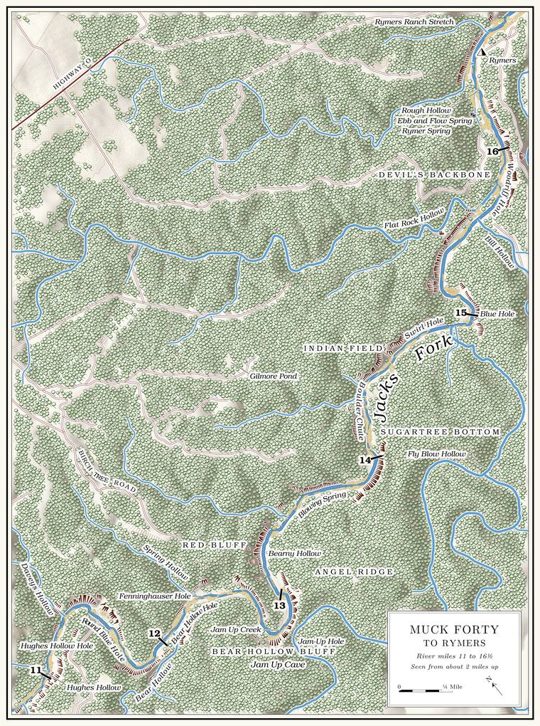
Below Muck Forty Hole the Jacks Fork runs five and a half milesmeasured along the river centerline traced for the maps in this book. to Rymers through a deep canyonThornberry-Ehrlich 2016, 25.. Through this reach the river falls about 7 feet a milethe river profile measured on the 2021–23 riverbed survey (Heimann, Atkinson and High 2025; Map 12); see Chapter 2.. The Bluff. A cliff along the river, usually on the outside of a bend, where the river has cut sideways into the hill. In this sense the word was first used in North America (Chapter 2; Chapter 18). Glossary → close in on the outsides of the bends and climb to nearly 300 feetmeasured on the flood-mapping terrain (Heimann, Atkinson and High 2025; Map 13); the tallest face in the reach, about 290 feet, is the bluff on the left at the Round Blue Hole, about mile 11.4, and the faces at Jam Up and Red Bluff reach about 250 and 230 feet; the state’s natural-area page gives “as high as 200 feet” (MDC, Jacks Fork Natural Area)., old red cedars grow from their ledgesMDC, Jacks Fork Natural Area., and the Gravel bar. A bank of chert gravel and sand, usually on the inside of a bend, bare at low water (Chapter 15; Chapter 18). Glossary → between them are wideJohnson 2007, 29; Dufur 2013, 20.. For about three miles in the middle of the reach the river runs through the Jacks Fork Natural AreaMDC, Jacks Fork Natural Area; Dufur 2013, 20., and at its center, on the outside of a hard bend, the right-hand bluffNPS 1960, 4. opens into the mouth of Jam Up Cave. The whole reach lies inside the national riverwayssee Chapter 10. (Chapter 10). Rymers, at the foot of the reach, is the first public landing below the Natural area. A Missouri tract set aside as one of the best remaining examples of the state’s native communities, to be managed to keep it that way. The Jacks Fork and Barn Hollow natural areas were designated on May 27, 1980 (Chapter 11). Glossary →MDC, Jacks Fork Natural Area; see Chapter 11. (Chapter 11).
The bluffs are Gasconade Dolomite near the water and the Roubidoux Formation above, and the contact between them shows as a change from sheer rock to ledges and overhangsThornberry-Ehrlich 2016, 25 (fig. 19); MSS 1982, 13–14; see Chapter 1. (Chapter 1). The river gains little water here. In the dry week of August 2006 it carried about 38 cubic feet a second both near Jam Up Cave and near Rymer Spring, about what had come down past Blue SpringMugel, Richards and Schumacher 2009, 27–28 (table 2); see Chapter 12. (Chapter 12).
The canyon holds some of the best Mussel. A freshwater clam that lives half-buried in the riverbed and filters its food from the water. Mussels on the Jacks Fork fell sharply between the surveys of 1982 and 2017–19 (Chapter 16). Glossary → water left on the river. In 2017–19 timed searches of the riverbed found 94 live mussels near Muck Forty, 49 near Lost Hollow and 63 a little above Rymer Spring, though only 2 at Rymers itself, a site first searched in 1982McMurray and Faiman 2023, 15 (table 3, river kilometers 56.5, 50.5, 50.1 and 48.2). The source gives sites by river kilometer only; the place names here are located from those distances.. In 2023 searchers found four species alive both in the natural area near Angel Ridge and near Rymer SpringWesthoff, Laszlo and Huggins 2026, appendix E, table 12 (sites 5A and 1A); see Chapter 16. (Chapter 16).
Blue Spring to Rymers is the usual day float through this country, about six and a half milesmeasured along the river centerline traced for the maps in this book., which a local floater makes in about three and a half hourssee Chapter 20 (Table 20.2). (Chapter 20).
The miles in the headings are counted from the junction of the Prong. A branch or arm of a creek, set down in 1860 as Southern usage. The North and South Prongs join to form the Jacks Fork (Chapter 18). Glossary → along the surveyed channel. Jam Up Cave is at about mile 12.8 and the Rymers landing at 16.5measured along the river centerline traced for the maps in this book.. Left and right are as you face downstream. Through most of the reach the river runs east, so river left is the north bank; near Rymers it turns north, and river left becomes the west bank.
Bend by bend
Hughes Hollow Hole and Daveys Hollow
Pool and hollow · left bank · about miles 11.2 to 11.3 · Plate A5
Below Muck Forty (Reach D) the river runs through Hughes Hollow Hole, known as a long, shallow Pool. A deep, slow stretch of river between riffles (Chapter 16). Glossary →Lewis 1980, PDF p. 27, the only source., and swings hard around the mouth of Daveys HollowPlate A5., which comes in on the left on the outside of the bend. The hollow is short, draining less than half a square mileJacks Fork Creek Network 2026 (0.4 square miles)., and is said to carry running waterLewis 1980, PDF p. 27 (“Davey’s Hollow runs water”), the only source.. The federal maps spell it without an apostropheUSGS GNIS; BGN 2016, 50 (federal names policy discourages possessive apostrophes)..
Round Blue Hole and the Holden Place
Pool and former farm · about mile 11.4 · Plate A5
The next pool, known as the Round Blue Hole, has a noisy spring at its upper end and a long bluff on the left streaked with red. A farm on the right above it was known as the Holden Place, and the pool was reached through itLewis 1980, PDF p. 27, the only source..
The Jacks Fork Natural Area
Protected area · both banks · from about mile 11.5 for three miles
A little below Daveys Hollow the river enters the Jacks Fork Natural Area, 966 acres of Park Service land that the state added to its natural-area system on May 27, 1980, the same day as Barn HollowMDC, Jacks Fork Natural Area; see Reach C and Chapter 11. upstream (Reach C; Chapter 11). Its upper end lies about four and a half river miles below the Highway 17 bridge and about two below Blue Spring, and it follows the river for about three milesMDC, Jacks Fork Natural Area; Dufur 2013, 20.. It takes in the gravel bars, the Dolomite. Calcium magnesium carbonate rock, a close relative of limestone, formed from lime mud on the floor of a warm, shallow sea. Nearly every bluff on the Jacks Fork is dolomite (Chapter 1). Glossary → cliffs and Glade. An opening where bedrock lies at or near the surface and the soil is too thin and dry for trees, usually on a south-facing slope (Chapter 16). Glossary →, the bottomland and upland forest, dry Woodland. The period of prehistory from about 600 B.C. to A.D. 900 in radiocarbon years, when people here first made pottery and took up the bow (Chapter 3). Glossary → and caves, and more than 450 native plants have been recorded in it, along with Forty. Forty acres, a quarter of a quarter section. A hill farm was often one or two forties (Chapter 5). Glossary → native fishes and four kinds of crayfishMDC, Jacks Fork Natural Area; Dufur 2013, 20, 23; see Chapter 16. in the river (Chapter 16). The hills along this part of the river were logged like the rest of the country, but no logging Tram, tramway. A light logging railroad laid up a hollow, such as Cordz-Fisher’s line down Pine Hollow (Chapter 7). Glossary → reached them, and the timber went out by wagon to the mills at Birch TreeMDC, Jacks Fork Natural Area; see Chapter 7. (Chapter 7). In 1981 the Park Service studied about 4,000 acres around Jam Up Cave as a possible Wilderness. Federal land designated by law to be kept without roads or development. About 4,000 acres around Jam Up Cave were studied for it in 1981 and judged unsuitable (Chapter 10). Glossary → and judged it unsuitableNPS 1981, 30, 126; see Chapter 10. (Chapter 10).
Near the head of the natural area, where the river turns south, a natural arch stands on the left bank, hidden by trees from the waterDufur 2013, 20 (“the west-facing slope”); Johnson 2007, 26 (“the east bank”). Both describe river left of a south-flowing stretch.. Behind the arch is a rock courtyard with two smaller openings into it, an alcove and, at the back, a cave passage about 140 feet long set with small formations, some of them broken, its floor trodden with footprints. It is also called Three Entrance CaveJohnson 2007, 26.. Its exact position has not been fixedthe arch is not lettered on Plate A5..
Bear Hollow, Bear Hollow Hole and Bear Hollow Bluff
Hollow, pool and bluff · right bank · about mile 12.1 · Plate A5
Bear Hollow comes in from the south, draining about a square mile and a halfJacks Fork Creek Network 2026 (1.6 square miles).. The pool at its mouth, known as Bear Hollow Hole, lies under a high, flat, gray bluff on the right, by one account the largest bluff on the river to this point. A small spring seeps from the bank below the pool, and about a mile and a half to the north a large marshy basinLewis 1980, PDF p. 27, the only source. marks one of the many Sinkhole. A hollow in the ground where rock below has dissolved or caved in, through which water drains underground; also called a sink, an American use (Chapter 2; Chapter 12). Glossary → of the upland.
High in Bear Hollow Bluff, above the bend, is the big entrance of Black Bluff Cave, about 25 feet high and 30 wide and plain from the river. A muddy slope leads back to a thick stand of columns and Stalactite, stalagmite. A stalactite hangs from a cave ceiling, built from dripping water. A stalagmite builds up from the floor where the drip lands (Chapter 13). Glossary →, and the cave runs only about 120 feet in all. Little Black Bluff CaveJohnson 2007, 26. is on the same stretch. The name Black Bluff was kept for the cave out of deference to whoever first named the cave, though the bluff’s own name is Bear Hollow BluffMSS 1982, 13; see Chapter 13. (Chapter 13).
Fenninghauser Hole and Spring Hollow
Pool and hollow · left bank · about miles 12.1 to 12.3 · Plate A5
Fenninghauser Hole, just above the mouth of Spring HollowLewis 1980, PDF p. 29 (map: lettered along the run that ends where Spring Hollow comes in); Jacks Fork Oral History, record SV-23 (marked on a map at about mile 12.1); the mouth of Spring Hollow: USGS GNIS (726934), measured on the river centerline (12.26)., begins a big bend, with a high bluff on the left and a spring on the right below the pool. A longtime angler and hunter of the middle river, who spells it Fennenhauser, remembers the place for camping, picnics and fishingJacks Fork Oral History, record SV-23..
Spring Hollow, a small hollow of about a third of a square mileJacks Fork Creek Network 2026 (0.3 square miles)., comes in on the left. It is said to be named for a spring that rises through its floor, and the pool at its mouth took the same name. Two more springs come out above Jam Up Cave, the first of them cascading over the rocks, a fine sight early in the yearLewis 1980, PDF p. 27, the only source..
Jam Up Bluff and Jam Up Cave
Bluff and natural tunnel · right bank · about mile 12.8 · Plate A5
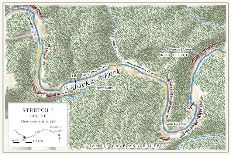
Jam Up Bluff, by one account the high point along the Jacks ForkNPS 1960, 19 (“the high point along Jacks Fork”), the only source. Taller faces stand above it, on the left at the Round Blue Hole (about 290 feet), and downstream; the tallest on the river, about 350 feet, is the face on the left bank across from Grandma Rocks (Reach G; Map 13)., climbs nearly to the rim of the upland on the outside of a sharp bend. In its face is the mouth of Jam Up Cave, an arch about 80 feet high and 100 feet wideMDC, Jacks Fork Natural Area; Dufur 2013, 21. at its base, half buried in fallen rockJohnson 2007, 26.. The bluff rises about 250 feet above the water just upstream of the cave mouth and about 210 feetthe right-bank faces at about miles 12.74 to 12.77 (tallest 12.76) and 12.84 to 12.98 (tallest 12.93), measured on the flood-mapping terrain (Heimann, Atkinson and High 2025; Map 13). The cave mouth and its slope of boulders probably lie in the break between the two faces, by the mouth of Jam Up Creek (12.80). just below it. Over a very long time slabs falling from the roof have enlarged the opening upward in rings, so that the arch has the shape of a bandshell, and its crown stands about 125 feet above the water, by one account close under the rimNPS 1960, 5, the only source. The faces beside the mouth measure about 210 and 250 feet (Map 13). of the canyon. The dark curve of the arch can be seen from far upstream. A slope of dolomite bouldersMDC, Jacks Fork Natural Area. falls from the entrance to the river, and the cave stream comes out on the left among the rocksJohnson 2007, 26–27.. A relatively fresh rockfall scar showed on the bluff face east of the cave in 2007Thornberry-Ehrlich 2016, 25 (fig. 19); see Chapter 1. (Chapter 1).
Strictly speaking Jam Up is a Natural tunnel. A cave open at both ends. Jam Up is a natural tunnel (Chapter 13; Reach E). Glossary →MDC, Jacks Fork Natural Area; see Chapter 13., a cave open at both ends (Chapter 13). Inside the arch a ridge of broken rock rises about 25 feet above the sloping floor, and behind it a hall runs back 350 to 400 feet among blocks the size of houses. Daylight reaches all the way in a dim, bluishJohnson 2007, 27. half-light. The hall ends at a deep pool in a pit where the roof of a lower level fell in, walled on three sides by cliffs about 20 feet high, and a waterfall pours into it from the cave’s upper level, carrying Jam Up Creek in from the far side of the ridge. On the far side of the ridge the upper level opens to daylight through a collapsed sinkhole about 60 feet across, a window through which the creek can be seen threading among fallen blocksNPS 1960, 4–5., and through a smaller skylightJohnson 2007, 28; MSS 1982, 35.. In floods the creek carries logs, sticks and leaves through the tunnel and jams them in the outlet, and the rubble ridge then acts as a partial dam; water has stood 15 to 20 feetNPS 1960, 5. deep behind it. Cavers who surveyed the whole system in October 1980 measured 1,749 feetMSS 1982, 36 (map). of passage.
An Eminence resident who has done park work remembers that a Section. A square mile of 640 acres, one thirty-sixth of a township. A quarter section is 160 acres (Chapter 5). Glossary → of the roof fell in, by that account in the late 1990sJacks Fork Oral History, record SV-12., and ceiling falls have happened in recent yearsNPS 2026 (Jam Up); see Chapter 13. (Chapter 13). A plan to raise mushrooms in the cave, about 1900, is said to have come to nothing, and a story is told of a horse that fell through the sinkholeLewis 1980, PDF pp. 27, 31, the only source. into the cave and lived. On September 1, 1940, Leslie Hubricht, a collector of snails, took a tiny spring snail of a kind that lives in springs and cave streams, along with a freshwater limpetField Museum of Natural History, Chicago, invertebrate collection, 283182 (Fontigens aldrichi, “Jam Up Cave”); University of Michigan Museum of Zoology, Ann Arbor, mollusk collection, 176189 (Ferrissia, “Jam Up Cave”)., from the cave; the specimens are in the Field Museum in Chicago and the University of Michigan’s Museum of Zoology.
Field work by the Missouri botanist B. F. Bush brought the plants around Jam Up Bluff to national attention long before the park. The magnesium-rich dolomite, caps of Roubidoux sandstone on the heights and slopes cut to face every direction pack a great many habitats into a small space, and by 1960 the list of plants found near the bluff and the cave included showy and small white lady’s-slippers, grass-of-Parnassus, American barberry, harebell and northern bedstraw, plants of the north mixed with plants of the Appalachians. They were taken then for a relic colonyNPS 1960, 19–20 (as Cypripedium reginae, C. candidum, Parnassia grandifolia, Berberis canadensis, Campanula rotundifolia, Galium boreale); see Chapter 16. left from the Ice Age (Chapter 16). Jam Up Bluff and Angel Ridge Bluff, a little downstream on the same side, are among the representative dolomite cliffs in the state’s classification of cliffsMDC, “Cliffs”; see Chapter 2. (Chapter 2).
Plants pressed at Jam Up are kept in herbaria as far apart as Columbia, St. Louis and San Diegothe specimens below.. Those collected in 1931 and 1932, in the University of Missouri’s herbarium, run from purple milkweed in the rocky woods and doll’s-eyes on the hillsides to bush clover on the glades, narrow-leaved bluets hanging from crevices in the bluff and leafy pondweed growing in the river itselfUniversity of Missouri Herbarium, Columbia, specimens 1616013 (August 13, 1931), 1681456, 1668062, 1634912, 1671893 and 1674505 (collector J. H. Kellogg; May 29 to September 4, 1932).. Julian Steyermark took autumn coralroot, a small leafless orchid, from the wooded ravine of Jam-up Hollow on November 30, 1935Missouri Botanical Garden Herbarium, St. Louis, specimen 3538101 (J. A. Steyermark, Corallorhiza odontorhiza, “Jam-up Hollow, 1 mi E of Jam-up”).. Bush, a storekeeper and botanist from Courtney in Jackson County, gathered hepatica on the rocky banks at Jam Up on April 17, 1936, when he was seventy-seven, ten months before his deathSan Diego Natural History Museum Herbarium, specimen SD00091314 (B. F. Bush 7050, Anemone americana, “Jam Up,” rocky banks; the label gives no county, and the place is taken to be this Jam Up); UNC Herbarium, “Benjamin Franklin Bush” (born December 21, 1858; storekeeper and postmaster at Courtney; died February 14, 1937), after Palmer 1937.. In November 1960 a moss specialist collecting around the cave and along Jam Up Creek took red-stemmed feathermossMissouri Botanical Garden Herbarium, specimen 90170667 (P. L. Redfearn Jr., Pleurozium schreberi, November 28, 1960, collected along Jam Up Creek and at Jam Up Cave and the bluffs along the river; also New York Botanical Garden, 624319, the same day)., a moss of the northern forests, and in May 1971 false bugbane, one of the plants on the 1960 list, was pressed on Jam Up BluffMissouri Botanical Garden Herbarium, specimen 3507791 (Arthur Christ, Trautvetteria caroliniensis, May 11, 1971, “Jam-up Bluff along Jack’s Fork of Current River”); on the 1960 list, NPS 1960, 19..
How Jam Up got its name, and the “Jimjam Cave”Dorrance 1938, 32; see Chapters 9 and 18. that a floater heard, probably in 1934, are in Chapters 18 and 9.
Jam-Up Hole and Jam Up Creek
Pool and creek mouth · right bank · about mile 12.8 · Plate A5
The pool below the cave, known as Jam-Up Hole, is full of large rocksLewis 1980, PDF p. 27, the only source, which calls the pool deep. and about 8 feet deep at Low Water. The local name for the Highway Y bridge over the South Prong, the access beside it and the county’s low-water crossing where the prongs meet, and so for the head of the river (Chapter 8; Chapter 18). Glossary →the pool’s depth below the riffle that holds it, measured on the 2021–23 riverbed survey (Heimann, Atkinson and High 2025; Map 12).. Jam Up Creek reaches the river on the right a short way below the portal, draining about 21 square miles. It heads in Mountain View and runs northeast toward the river, but below the town its water sinks into its bed and travels underground to Big Springsee Chapter 12. on the Current River (Chapter 12). Above the tunnel it runs through a canyon of its own, and its largest Branch. A small creek. The sense is American, on record from 1674 (Chapter 18). Glossary → near the river, an unnamed hollow of about two and a half square miles, joins it from the west a little over half a mile above the mouthJacks Fork Creek Network 2026 (Jam Up Creek, 20.7 square miles)..
The narrow ridge between the creek and the river, the ridge that the tunnel pierces, is called the Devil’s BackboneJohnson 2007, 28., a name also given to the ridge between the river and Johnny Hollow on the right bank above RymersLewis 1980, PDF p. 30 (“above the river to the left of Johnny Hollow, by Rymer’s Ranch”) and the map on PDF p. 33 (“Devils Backbone” lettered south of the river, between it and Johnny Hollow, above Rymer’s Ranch).. Jam Up Creek probably once ran north toward the river on the far side of this ridge while the river cut south toward it from the other side. The creek’s bed broke through into a cave passage already dissolved in the rock, the creek followed the passage to the river, and its old valley below the break was left without a stream. That valley is taken to be Lost HollowNPS 1960, 4; MSS 1982, 34., which reaches the river two miles downstream (below). Piracy of this kind, through a cave, is very rareNPS 1960, 4 (“almost unique”); see Chapter 13. (Chapter 13).
A little downstream of the cave an immense gravel bar has built up on the inside of the bend, long used as a campJohnson 2007, 29; Dufur 2013, 21; see Chapter 20. (Chapter 20).
Red Bluff and Bearny Hollow
Bluff, cave and hollow · left bank · about miles 13.3 to 13.4 · Plate A5
About half a mile below Jam UpPlate A5. the left bank rises into Red Bluff, a cliff about 230 feet highthe left-bank face at about miles 13.14 to 13.33, tallest at 13.23, measured on the flood-mapping terrain (Heimann, Atkinson and High 2025; Map 13). streaked with red from iron oxide in the clay, with a good poolLewis 1980, PDF p. 31. below it. In its face, visible from the river through the trees, is Red Bluff Cave, a dry entrance about 10 feet wide and 20 high that narrows to a low crawl within 40 feet. Pockets in the rock near its mouth hold what look like pack rats’ nestsJohnson 2007, 29..
A short way downstream a branch of about half a square mileJacks Fork Creek Network 2026 (0.5 square miles). comes in on the left, known as Bearny HollowLewis 1980, PDF p. 31 and map, PDF p. 29, the only source.. That angler calls it the “Spring Hole. Any pool deep enough to swim or fish in, named or not, the basic unit of the river in local speech; also “hole of water” (Chapter 18). Glossary →”Jacks Fork Oral History, record SV-23; see Chapter 18. (Chapter 18).
Blowing Spring Hole, Sugartree Bottom and Boulder Chute
Pool, bottom and chute · about miles 13.8 to 14.3 · Plate A5
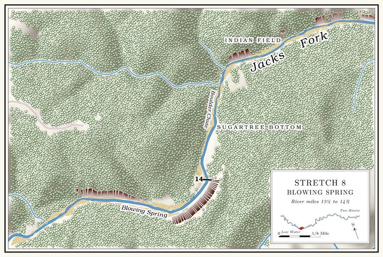
Blowing Spring Hole, about 5 feet deep at low waterthe pool’s depth below the riffle that holds it, measured on the 2021–23 riverbed survey (Heimann, Atkinson and High 2025; Map 12)., is known by a small, noisy spring. Below it, on the left, lies Sugartree Bottom, said to be named for the large sugar maples that once grew there. The river sweeps past a high cut bank of clay on the left into Boulder Chute, a long, narrow, rough run lined with large rocksLewis 1980, PDF pp. 30–31, the only source.. Up on the north side, a pond on the upland is lettered Gilmore PondPlate A5; USGS GNIS..
To the right the narrow ridge called Angel Ridge separates the river from Lost HollowLewis 1980, PDF p. 30.. Its river face is Angel Ridge BluffMDC, “Cliffs”; see Chapter 2. (Chapter 2).
Lost Hollow, Fly Blow Hollow and Indian Field
Hollow, former ford and homesite · both banks · about mile 14.9 · Plate A5
Lost Hollow comes in from the south at a sharp bend, draining about five square miles. Its lower course is taken to be the abandoned valley of Jam Up Creek, and with no large stream left to deepen it, the valley floor has stayed close to the Grade. The slope at which a river carries its load without cutting down or building up (Chapter 2). Glossary → it had when the creek was captured, while the creek above the point of capture has cut perhaps 20 feet lower. Near its mouth the hollow shows the work of two streams cutting against each otherNPS 1960, 4–5., the old creek and a tributary from the south. Fly Blow Hollow, a short side valley of a little over half a square mileJacks Fork Creek Network 2026 (Lost Hollow 5.0 square miles; Fly Blow Hollow 0.6)., joins it from the west a little above the mouth and gives its name to one of the short Fault. A break in the rock along which one side has moved. The faults that mark the Eminence caldera run northeast and northwest (Chapter 1). Glossary →Weary and others 2014, 10; see Chapter 1. mapped across the upper river (Chapter 1). That angler calls the creek “Flyblow” and says it runs all year.
Water still comes out of Lost Hollow. Around 1980 a good stream ran from it, cold enough to tell that a large spring was near, several feet deep in places behind beaver dams. Near its mouth three large springs come up, one through the floor on the west side of the creek and two through the rocks on the east side, and one of them once had a water pipe running from it; that angler knows a “Pipe spring” there. The springs rise beside the Old Simms Place, by one account one of the more beautiful homesites along the river, long since grown up in brushLewis 1980, PDF p. 30, the only source.. The ridge to the east, which the federal maps call Jenny RidgeUSGS GNIS., is the “Simms track”Jacks Fork Oral History, record SV-23. to the same angler.
The old road from Birch Tree to Summersville came down Lost Hollow from Fly Blow Hollow and crossed the river at its mouth at McIntire FordLewis 1980, PDF p. 30, the only source., lettered McIntyre FordUSGS 1948 (Summersville). on the 1948 topographic map. On the left above the Ford. A place where a road crosses through the water. Many of the river’s fords took the names of the families who lived beside them (Chapter 8). Glossary → is the Indian Field, said to be one of many old Indian campgroundsLewis 1980, PDF p. 30, the only source; see Chapter 3. along the river (Chapter 3).
Swirl Hole and the Blue Hole
Pools · about miles 14.9 to 15.0 · Plate A5
At the mouth of Lost Hollow is Swirl Hole, a deep pool, and immediately below it the Blue Hole, by one account one of the deepest holesLewis 1980, PDF p. 30, the only source. on the river. At low water Swirl Hole is about 5 feet deep and the Blue Hole about 8each pool’s depth below the riffle that holds it, measured on the 2021–23 riverbed survey (Heimann, Atkinson and High 2025; Map 12), on which the deepest pools of the river measure 8 to 10 feet.. This is a second Blue HolePlate A5; see Reach C and Chapter 18. on the upper Jacks Fork, distinct from the one in Reach C (Chapter 18). A primitive campsite called Blue Hole was on the park’s list in 1981, between Baptizing Hole and Flat RockNPS 1981, 127..
Meeting House Cave
Cave and pool · left bank · about mile 15.5
The next pool, known as Meeting House Cave Hole, lies under a long bluff on the left. Meeting House Cave opens in the bluff with one of the largest entrances on the river, and around 1980 a large bur oakLewis 1980, PDF p. 30, the only source for the oak. grew in its mouth. Its main passage starts big, pinches down quickly and gives only about 220 feetJohnson 2007, 31. of passage. That angler calls it the “Church house cave.” The legend that both sides used it during the Civil WarNPS 1977; Lewis 1980, PDF p. 30; see Chapter 13., and what the name may mean, are in Chapter 13. Gnarled red cedars grow from the bluff along the pool, said to be among the oldest trees in the Ozarks because they were of no use as timber and hard to reachLewis 1980, PDF p. 30, the only source..
Bill Hollow, Rock Hollow, Flat Rock Hollow and Woodriff Hole
Hollows and pool · about miles 15.6 to 15.8 · Plate A5
Jenny Ridge separates Lost Hollow from Bill HollowLewis 1980, PDF p. 30. on the south side of the river. Bill Hollow comes in on the right, draining about three square milesJacks Fork Creek Network 2026 (Bill Hollow, 3.1 square miles).. Rock HollowUSGS 1948 (Summersville)., lettered on the 1948 topographic map, comes in on the left a little below, and Flat Rock Hollow enters on the left a little beyond. Flat Rock Hollow drains about five square milesJacks Fork Creek Network 2026 (Flat Rock Hollow, 5.1 square miles). of the upland to the north, more than any other side stream of the reach except Jam Up Creek. It holds water in several places and by one account runs only in wet weatherLewis 1980, PDF p. 30, the only source. The hollow was running at about 0.9 cubic foot a second on August 16, 2006, during a drought (Mugel, Richards and Schumacher 2009, 27–28, table 2).. Woodriff Hole, by one account a favorite swimming holeLewis 1980, PDF p. 30, the only source., lies on this stretch. The park has kept a primitive camping area called Flat Rock on this stretch since at least 1981NPS 1981, 127; NPS 2022a, E-6 (Flat Rock Primitive Area)..
The club cabins
Former club grounds · left bank · about mile 16.0
Below Flat Rock Hollow the river runs through a rough divided Chute. A narrow, fast slot of water through a shoal or past an obstacle. A smooth V of water pointing downstream marks the deepest path through it (Chapter 20). Glossary →, over several rocks and around a couple of turnsLewis 1980, PDF p. 30, the only source., past the ground of the Shannon County Hunting and Fishing Club. Springfield men incorporated the club in 1912 and built ten cabins here on the west bankLewis 1980, PDF p. 30. near Ebb and Flow SpringStevens 1991, 151–52; NPS, “Rymers Ranch History”; see Chapters 9 and 10. (Chapters 9 and 10). In October 1934 a botanist gathering plants on the river banks and Bottom. The flat land along a river or creek, built of its deposits and open to its floods. In the 1920s the bottoms near Eminence averaged about a quarter of a mile wide (Chapter 2; Chapter 5). Glossary → here and on the bluff top to the south labeled them by “Ebb-and-Flow Camp” near Birch TreeUniversity of Missouri Herbarium, Columbia, specimens 1603926, 1609772 and 100324590 (H. W. Rickett, October 13–14, 1934, “banks of Jack’s Fork S of Ebb-and-Flow Camp, near Birch Tree”; “bottoms of Jack’s Fork near Ebb-and-Flow Camp”; “top of bluff south of Ebb-and-Flow Camp”). That the camp was the club’s is an inference., probably the club’s camp. Several of the cabins were still standing, in poor repair, around 1980Lewis 1980, PDF p. 30; see Chapter 9. (Chapter 9).
Ebb and Flow Spring and Rymer Spring
Spring · left bank · about mile 16.2 · Plate A5
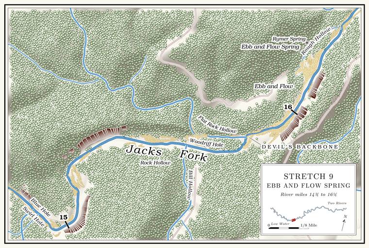
About three-tenths of a mile above the Rymers landing, on the leftMDC 2003, miles 15.9 and 16.2., is the spring that pulses, known both as Ebb and Flow Spring and as Rymer Spring; the two names appear to belong to one springLewis 1980, PDF p. 30 (“Rymer’s Ebb and Flow Spring”) and map, PDF p. 33; USGS 1948 (Summersville; the spring symbol lettered Ebb and Flow Spring lies about 20 meters from the point the federal names list gives for Rymer Spring); USGS GNIS; see Chapter 12.. Most of its water comes up in a round basin above the level of the river, and some enters through the rocks at the river’s edgeLewis 1980, PDF p. 30., with a short Spring branch. The stream that runs from a spring to the river, such as the branch below Alley Spring (Reach H). Glossary →USGS GNIS; Plate A5. to the river. How such springs work is taken up in Chapter 12.
A road built in 1916 from Birch Tree to the Ebb and Flow Spring came down to the river along the Devil’s Backbone, the ridge between the river and Johnny HollowLewis 1980, PDF p. 33 (map)., ran past the later site of Rymer’s ranch and crossed the river to the clubLewis 1980, PDF p. 30, the only source.. In April 2007, after rain, cavers floating toward Rymers noticed a spring branch on the left above the landing with water distinctly blue, and took it for the way to Rymer SpringJohnson 2007, 31..
The spring drew naturalists early. Julian Steyermark collected capillary beak-rush on the moist, shaded bluffs near it on July 16, 1932Missouri Botanical Garden Herbarium, St. Louis, specimen 3545552 (J. A. Steyermark, Rhynchospora capillacea, “along Jack’s Fork of Current River, near Ebb and Flow Springs N of Montier on moist shaded limestone bluffs”)., and Leslie Hubricht took a bladder snail from the spring the next dayUniversity of Michigan Museum of Zoology, Ann Arbor, mollusk collection, 176926 (Physella gyrina aurea, July 17, 1932, “Ebb & Flow Spring, 5 mi. n.w. of Birchtree”).. Fish taken at the spring in 1939 and kept at the Field Museum include hornyhead chubs, banded darters, northern studfish and rock bassField Museum of Natural History, Chicago, fish collection, 60370, 60722, 60576 and 60629 (L. P. Woods, 1939, “Ebb and Flow Spring 7 mi. NE of Montier”)., and the museum also holds spothanded crayfish taken there on August 26, 1939Field Museum of Natural History, crustacean collection, 10936 (Orconectes [Faxonius] punctimanus). (Reach D).
Rough Hollow
Hollow · left bank · about mile 16.3 · Plate A5
Rough Hollow comes in on the left a little above the Rymers landing, on the opposite bank, draining a little over a square mileJacks Fork Creek Network 2026 (1.1 square miles).. In April 2007 cavers paddled up it as far as they could before the brush closed inJohnson 2007, 31.. That angler calls it “Ebb n flow.”
Rymers
Landing and backcountry campground · right bank · mile 16.5 · Plate A5
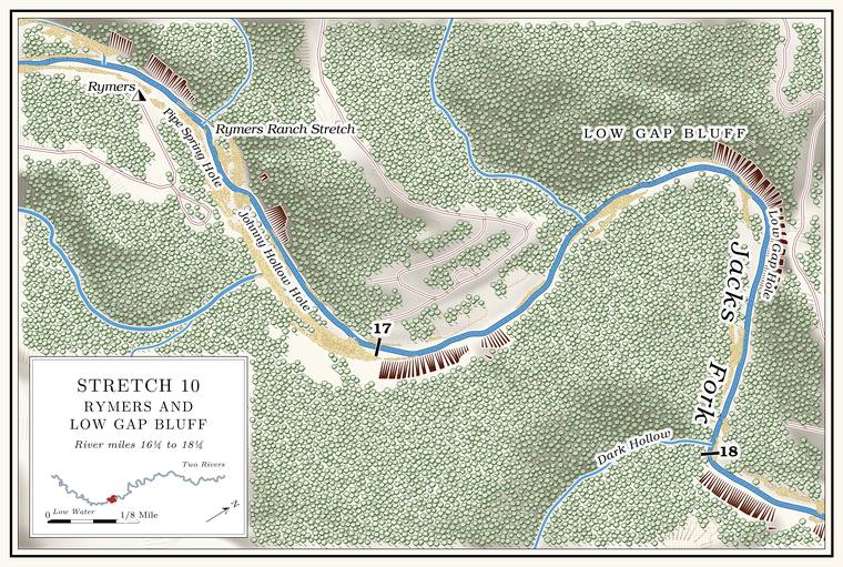
Rymers is a Park Service landing and backcountry campgroundNPS 2022a, E-6 (Rymers Backcountry Area); see Chapter 11. on the right bank, at the end of a county road from Highway MNPS 1977; MDC, Jacks Fork Natural Area. (Chapter 11). It takes its name from Rymer’s Rustic Ranch, a resort of the 1920s and 1930ssee Chapter 9. (Chapter 9), and the name has been written Rymer, Rhymer and Rymer’sO’Brien 1939, 112; see Chapter 18. (Chapter 18). A cable is said to have run from the ranch to the spring, carrying water in a bucketLewis 1980, PDF p. 30, the only source.. The water past the old ranch was known as the Rymers Ranch Stretch, with a long bluff on its rightLewis 1980, PDF p. 30 and map, PDF p. 33, the only source..
Places not yet placed
The Turnip Patch, Hickory Flat Hollow and Birch Prairie. The Turnip Patch is lettered on the right bank below Red Bluff on a river map of 1980, and Hickory Flat Hollow and Birch Prairie on the upland south of the river in the Jam Up Creek countryLewis 1980, map, PDF p. 29, the only source.. None has been fixed on the ground.
The blow-hole of the 1930s. A cold-air blow-hole a floater was shown, probably in 1934, somewhere above Jam UpDorrance 1938, 31; see Chapters 9 and 13. has not been found since (Chapter 13).
On to Reach F
Below Rymers the river bends northeast past Johnny Hollow toward Bunker HillPlates A5 and A7; USGS GNIS., the start of Reach F and Plate A7. Rules for the river are in Part Six.
| Creek | Bank | Mile | Drainage | Name |
|---|---|---|---|---|
| Daveys Hollow | left | about 11.3 | 0.4 sq mi | federal map |
| Bear Hollow | right | about 12.1 | 1.6 sq mi | federal map |
| Spring Hollow | left | about 12.3 | 0.3 sq mi | federal map |
| Jam Up Creek | right | about 12.8 | 20.7 sq mi | federal map |
| Bearny Hollow | left | about 13.4 | 0.5 sq mi | map of 1980 |
| Lost Hollow, with Fly Blow Hollow | right | about 14.9 | 5.0 sq mi | federal map |
| Bill Hollow | right | about 15.6 | 3.1 sq mi | federal map |
| Rock Hollow | left | about 15.7 | not traced | 1948 topographic map |
| Flat Rock Hollow | left | about 15.8 | 5.1 sq mi | federal map |
| Rough Hollow | left | about 16.3 | 1.1 sq mi | federal map |