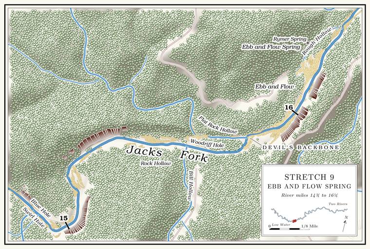
Lost Hollow, Fly Blow Hollow and Indian Field
Hollow, former ford and homesite · both banks · about mile 14.9 · Plate A5
Lost Hollow comes in from the south at a sharp bend, draining about five square miles. Its lower course is taken to be the abandoned valley of Jam Up Creek, and with no large stream left to deepen it, the valley floor has stayed close to the Grade. The slope at which a river carries its load without cutting down or building up (Chapter 2). Glossary → it had when the creek was captured, while the creek above the point of capture has cut perhaps 20 feet lower. Near its mouth the hollow shows the work of two streams cutting against each otherNPS 1960, 4–5., the old creek and a tributary from the south. Fly Blow Hollow, a short side valley of a little over half a square mileJacks Fork Creek Network 2026 (Lost Hollow 5.0 square miles; Fly Blow Hollow 0.6)., joins it from the west a little above the mouth and gives its name to one of the short Fault. A break in the rock along which one side has moved. The faults that mark the Eminence caldera run northeast and northwest (Chapter 1). Glossary → mapped across the upper river (Chapter 1). That angler calls the creek “Flyblow” and says it runs all year.
Water still comes out of Lost Hollow. Around 1980 a good stream ran from it, cold enough to tell that a large spring was near, several feet deep in places behind beaver dams. Near its mouth three large springs come up, one through the floor on the west side of the creek and two through the rocks on the east side, and one of them once had a water pipe running from it; that angler knows a “Pipe spring” there. The springs rise beside the Old Simms Place, by one account one of the more beautiful homesites along the river, long since grown up in brushLewis 1980, PDF p. 30, the only source.. The ridge to the east, which the federal maps call Jenny RidgeUSGS GNIS., is the “Simms track”Jacks Fork Oral History, record SV-23. to the same angler.
The old road from Birch Tree to Summersville came down Lost Hollow from Fly BlowWeary and others 2014, 10; see Chapter 1. Hollow and crossed the river at its mouth at McIntire FordLewis 1980, PDF p. 30, the only source., lettered McIntyre FordUSGS 1948 (Summersville). on the 1948 topographic map. On the left above the Ford. A place where a road crosses through the water. Many of the river’s fords took the names of the families who lived beside them (Chapter 8). Glossary → is the Indian Field, said to be one of many old Indian campgroundsLewis 1980, PDF p. 30, the only source; see Chapter 3. along the river (Chapter 3).
Swirl Hole and the Blue Hole
Pools · about miles 14.9 to 15.0 · Plate A5
At the mouth of Lost Hollow is Swirl Hole, a deep Pool. A deep, slow stretch of river between riffles (Chapter 16). Glossary →, and immediately below it the Blue Hole, by one account one of the deepest Hole. Any pool deep enough to swim or fish in, named or not, the basic unit of the river in local speech; also “hole of water” (Chapter 18). Glossary →Lewis 1980, PDF p. 30, the only source. on the river. At Low Water. The local name for the Highway Y bridge over the South Prong, the access beside it and the county’s low-water crossing where the prongs meet, and so for the head of the river (Chapter 8; Chapter 18). Glossary → Swirl Hole is about 5 feet deep and the Blue Hole about 8each pool’s depth below the riffle that holds it, measured on the 2021–23 riverbed survey (Heimann, Atkinson and High 2025; Map 12), on which the deepest pools of the river measure 8 to 10 feet.. This is a second Blue HolePlate A5; see Reach C and Chapter 18. on the upper Jacks Fork, distinct from the one in Reach C (Chapter 18). A primitive campsite called Blue HoleNPS 1981, 127. was on the park’s list in 1981, between Baptizing Hole and Flat Rock.
Meeting House Cave
Cave and pool · left bank · about mile 15.5
The next pool, known as Meeting House Cave Hole, lies under a long Bluff. A cliff along the river, usually on the outside of a bend, where the river has cut sideways into the hill. In this sense the word was first used in North America (Chapter 2; Chapter 18). Glossary → on the left. Meeting House Cave opens in the bluff with one of the largest entrances on the river, and around 1980 a large bur oak grew in its mouth. Its main passage starts big, pinches down quickly and gives only about 220 feetJohnson 2007, 31. of passage. That angler calls it the “Church house cave.” The legend that both sides used it during the Civil WarNPS 1977; Lewis 1980, PDF p. 30; see Chapter 13., and what the name may mean, are in Chapter 13. Gnarled red cedars grow from the bluff along the pool, said to be among the oldest trees in the Ozarks because they were of no use as timber and hard to reachLewis 1980, PDF p. 30, the only source..
Bill Hollow, Rock Hollow, Flat Rock Hollow and Woodriff Hole
Hollows and pool · about miles 15.6 to 15.8 · Plate A5
Jenny Ridge separates Lost Hollow from Bill HollowLewis 1980, PDF p. 30. on the south side of the river. Bill Hollow comes in on the right, draining about three square milesJacks Fork Creek Network 2026 (Bill Hollow, 3.1 square miles).. Rock HollowUSGS 1948 (Summersville)., lettered on the 1948 topographic map, comes in on the left a little below, and Flat Rock Hollow enters on the left a little beyond. Flat Rock Hollow drains about five square milesJacks Fork Creek Network 2026 (Flat Rock Hollow, 5.1 square miles). of the upland to the north, more than any other side stream of the reach except Jam Up Creek. It holds water in several places and by one account runs only in wet weatherLewis 1980, PDF p. 30, the only source. The hollow was running at about 0.9 cubic foot a second on August 16, 2006, during a drought (Mugel, Richards and Schumacher 2009, 27–28, table 2).. Woodriff Hole, by one account a favorite swimming holeLewis 1980, PDF p. 30, the only source., lies on this stretch. The park has kept a primitive camping area called Flat Rock on this stretch since at least 1981NPS 1981, 127; NPS 2022a, E-6 (Flat Rock Primitive Area)..
The club cabins
Former club grounds · left bank · about mile 16.0
Below Flat Rock Hollow the river runs through a rough divided Chute. A narrow, fast slot of water through a shoal or past an obstacle. A smooth V of water pointing downstream marks the deepest path through it (Chapter 20). Glossary →, over several rocks and around a couple of turnsLewis 1980, PDF p. 30, the only source., past the ground of the Shannon County Hunting and Fishing Club. Springfield men incorporated the club in 1912Stevens 1991, 151–52; NPS, “Rymers Ranch History”; see Chapters 9 and 10. and built ten cabins here on the west bankLewis 1980, PDF p. 30. near Ebb and Flow Spring (Chapters 9 and 10). In October 1934 a botanist gathering plants on the river banks and Bottom. The flat land along a river or creek, built of its deposits and open to its floods. In the 1920s the bottoms near Eminence averaged about a quarter of a mile wide (Chapter 2; Chapter 5). Glossary → here and on the bluff top to the south labeled them by “Ebb-and-Flow Camp” near Birch TreeUniversity of Missouri Herbarium, Columbia, specimens 1603926, 1609772 and 100324590 (H. W. Rickett, October 13–14, 1934, “banks of Jack’s Fork S of Ebb-and-Flow Camp, near Birch Tree”; “bottoms of Jack’s Fork near Ebb-and-Flow Camp”; “top of bluff south of Ebb-and-Flow Camp”). That the camp was the club’s is an inference., probably the club’s camp. Several of the cabins were still standing, in poor repair, around 1980Lewis 1980, PDF p. 30; see Chapter 9. (Chapter 9).
Ebb and Flow Spring and Rymer Spring
Spring · left bank · about mile 16.2 · Plate A5
About three-tenths of a mile above the Rymers landing, on the leftMDC 2003, miles 15.9 and 16.2., is the spring that pulses, known both as Ebb and Flow Spring and as Rymer Spring; the two names appear to belong to one spring. Most of its water comes up in a round basin above the level of the river, and some enters through the rocks at the river’s edgeLewis 1980, PDF p. 30., with a short Spring branch. The stream that runs from a spring to the river, such as the branch below Alley Spring (Reach H). Glossary →USGS GNIS; Plate A5. to the river. How such springs work is taken up in Chapter 12.
A road built in 1916 from Birch Tree to the Ebb and Flow Spring came down to the river along the Devil’s Backbone, the ridge between the river and Johnny HollowLewis 1980, PDF p. 33 (map)., ran past the later site of Rymer’s ranch and crossed the river to the clubLewis 1980, PDF p. 30, the only source.. In April 2007, after rain, cavers floating toward Rymers noticed a spring branch on the left above the landing with water distinctly blue, and took it for the way to Rymer SpringJohnson 2007, 31..
The spring drew naturalists early. Julian Steyermark collected capillary beak-rush on the moist, shaded bluffs near it on July 16, 1932Missouri Botanical Garden Herbarium, St. Louis, specimen 3545552 (J. A. Steyermark, Rhynchospora capillacea, “along Jack’s Fork of Current River, near Ebb and Flow Springs N of Montier on moist shaded limestone bluffs”)., and Leslie Hubricht took a bladder snail from the spring the next dayUniversity of Michigan Museum of Zoology, Ann Arbor, mollusk collection, 176926 (Physella gyrina aurea, July 17, 1932, “Ebb & Flow Spring, 5 mi. n.w. of Birchtree”).. Fish taken at the spring in 1939 and kept at the Field Museum include hornyhead chubs, banded darters, northern studfish and rock bassField Museum of Natural History, Chicago, fish collection, 60370, 60722, 60576 and 60629 (L. P. Woods, 1939, “Ebb and Flow Spring 7 mi. NE of Montier”)., and the museum also holds spothanded crayfish taken there on August 26, 1939Field Museum of Natural History, crustacean collection, 10936 (Orconectes [Faxonius] punctimanus). (Reach D).