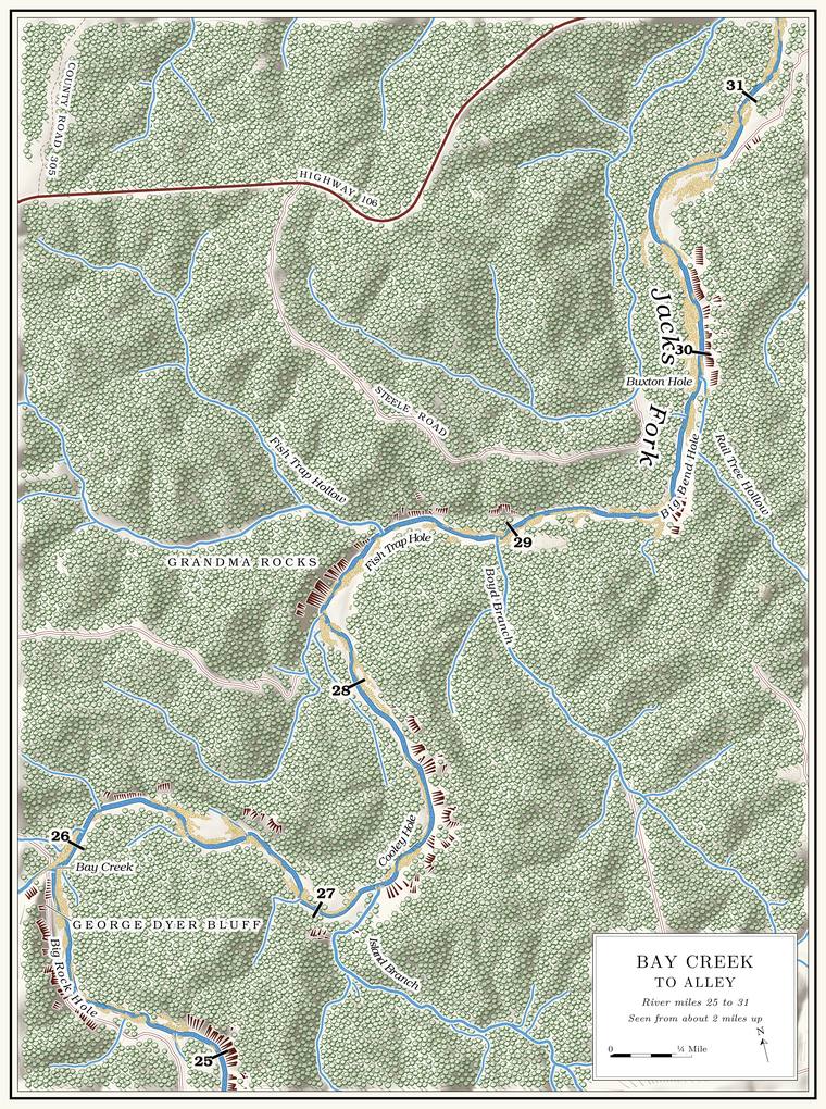
Below Bay Creek the Jacks Fork runs about five and a half milesmeasured along the river centerline traced for the maps in this book (mouth of Bay Creek 25.9, head of the Alley Spring Campground about 31.3; see the note to On to Reach H). to the head of the Alley Spring Campground, the last stretch of the upper river. From the mouth of the creek it swings east past Flat Top Bluff to the mouth of Island Branch, turns north along Grandma Rocks, bends east again at Fish Trap Hollow and runs past Boyd Branch to a big bend at Rail Tree Hollow, where it turns north for the last two milesPlate A9; Lewis 1980, PDF pp. 43–44, 47 (text and maps). into Alley. Through this reach the river falls about 7 feet a milethe river profile measured on the 2021–23 riverbed survey (Heimann, Atkinson and High 2025; Map 12); see Chapter 2.. Bay Creek to Alley is floated as a trip of its own, the link between the upper river’s floats and the lower river’ssee Chapter 20 (Windy’s Floats 2026; MDC 2003). (Chapter 20).
Here the valley begins to open. Above Bay Creek the river runs in a valley that is nearly a canyonMDC 2003; see Chapter 20.. Below it the valley widens in places to half a mile, and from a little above Alley Spring on down the Bottom. The flat land along a river or creek, built of its deposits and open to its floods. In the 1920s the bottoms near Eminence averaged about a quarter of a mile wide (Chapter 2; Chapter 5). Glossary → were wide enough to farm, so crops were more commonJacobson and Primm 1994, 54 (“Crops were more common downstream from immediately above Alley Spring where the valley begins to widen”). there than on the narrow river above. Some of the largest Bluff. A cliff along the river, usually on the outside of a bend, where the river has cut sideways into the hill. In this sense the word was first used in North America (Chapter 2; Chapter 18). Glossary → on the river stand here, sheer faces of 200 to 300 feet and, across from Grandma Rocks, the tallest on the rivermeasured on the flood-mapping terrain (Heimann, Atkinson and High 2025; Map 13): faces of about 200 to 300 feet on the right below Island Branch (about miles 27.2 to 27.7), at the big bend above Rail Tree Hollow (29.5 to 29.6) and across from Buxton Hole (30.0 to 30.3), and about 350 feet on the left across from Grandma Rocks (28.3); see Chapter 2., though they hold few caves compared with the bluffs upstreamJohnson 2007, 33 (which gives about 200 feet and, from the topographic map, close to 300).. Large Gravel bar. A bank of chert gravel and sand, usually on the inside of a bend, bare at low water (Chapter 15; Chapter 18). Glossary → are among the main featuresLewis 1980, PDF p. 46 (photograph caption). of the stretch. The inferred trace of the Low Wassie Fault. A break in the rock along which one side has moved. The faults that mark the Eminence caldera run northeast and northwest (Chapter 1). Glossary → crosses the river a short way below Bay Creek, and the Hartshorn fault crosses about a mile above AlleyWeary and others 2013 and 2014, GIS data (faults), laid against the river centerline; see Chapter 1. (Chapter 1).
By one account of 1980, the logging era had changed this stretch perhaps more than any other part of the river, and few places below Bay Creek could still be called a Hole. Any pool deep enough to swim or fish in, named or not, the basic unit of the river in local speech; also “hole of water” (Chapter 18). Glossary → of water. The bed had shifted again and again, leaving its old channels and filling the sloughs and bays beside them, the river divided into several Chute. A narrow, fast slot of water through a shoal or past an obstacle. A smooth V of water pointing downstream marks the deepest path through it (Chapter 20). Glossary → in high water, and in the dry months it could be called a mere creekLewis 1980, PDF pp. 40, 44, the only source.. By the same account the causes were the stripping of the forests and the yearly burning that followed, which left the hillsides bare to shed their Chert. A hard, fine-grained form of silica that forms in nodules and beds inside dolomite and stays behind when the dolomite dissolves. Most Ozark people call it flint. It makes up the river’s gravel and was the stone of the first people’s tools (Chapter 1; Chapter 3). Glossary → down the hollows to the river, and the clearing of the banks, which opened up gravel that had long lain buried under the soilLewis 1980, PDF pp. 40, 45, the account’s own explanation; see Chapter 15. (Chapter 15). Between Bay Creek and Alley the river line on the topographic sheet of 1917 lies 500 feet or more from today’s channel in four places, near miles 27, 28, 30 and 31; whether the river moved there or the 1917 surveyors drew it loosely is unsettledthe river line of USGS 1917 (Eminence), traced and laid against today’s channel on the 2021–23 riverbed survey (Heimann, Atkinson and High 2025; Map 11): 150 to 225 meters apart near miles 27 and 28, from 30.1 to 30.8 and from 31.3 to 31.5. Above Bay Creek the 1948 sheet’s line runs within about 65 feet of today’s channel along most of the river. See Chapter 15. (Chapter 15). A photograph taken upstream from Alley Spring about 1925 shows a wide, steady channel with vegetated banks, and a photograph of 1992 from the same place shows an extensive gravel barJacobson and Primm 1994, 68, 71 (fig. 24, “The Jacks Fork upstream from Alley Spring, Missouri, about 1925 and 1992”).. An aerial photograph of November 1990 shows new gravel spread over what had been a productive fieldJacobson and Primm 1994, 35 (fig. 17, “Jacks Fork—extensive gravel aggradation on top of a once-productive field”)., also upstream from the spring.
The logger who salted his cattle at Johnny Hollow, and who guided fishermen down near AlleyJacobson and Primm 1994, 51 (Oliver Beavers); see Reach F and Chapter 5., remembered a family close to the spring who planted their crops to the river’s edge and fought to keep their bottom: “they’d clean out the main channel . . . to keep the river from making a rain channel,” and where the river came around a bend and cut into their land, “They’d cut saplings and brush and bank in against the bank there to keep it from washing out.” He also watched the river above Alley straighten and fillJacobson and Primm 1994, 57; see Chapter 15. (Chapter 15).
In the dry week of August 2006 the river carried about 45 cubic feet of water a second above Bay Creek and about 51 at the Alley Gauge. A station of the Geological Survey that records the river’s stage, from which its flow is figured. The Jacks Fork has gauges at Highway 17, Alley and Eminence (Chapter 14). Glossary →, above the Spring branch. The stream that runs from a spring to the river, such as the branch below Alley Spring (Reach H). Glossary →Mugel, Richards and Schumacher 2009, 27–28 (table 2: Jacks Fork upstream from Bay Creek, site 83, about 1.8 miles above the mouth of the creek, 44.9, August 17, 2006; Jacks Fork at Alley Spring gauge 51.1); see Chapter 12. (Chapter 12). The last few miles above Alley are wide and shallow and may have to be walked in Low Water. The local name for the Highway Y bridge over the South Prong, the access beside it and the county’s low-water crossing where the prongs meet, and so for the head of the river (Chapter 8; Chapter 18). Glossary →MDC 2003; see Chapter 20.. Cavers who floated past Bay Creek to Alley in April 2007, with the water still up several inches, scraped gravel now and then and never had to get out of their canoes, and Outfitter. A business that rents boats to floaters and runs their shuttles (Chapter 20). Glossary → at the time would not rent canoes for the stretch in summer, for fear the rocks would beat them upJohnson 2007, 33.. A floater, probably in 1934, found the Pool. A deep, slow stretch of river between riffles (Chapter 16). Glossary → growing “wider, deeper, longer”Dorrance 1938, 33; see Chapter 9. as the valley opened toward Alley (Chapter 9).
Mussel. A freshwater clam that lives half-buried in the riverbed and filters its food from the water. Mussels on the Jacks Fork fell sharply between the surveys of 1982 and 2017–19 (Chapter 16). Glossary → are scarce here. In 2017–19 timed searches found none, two and six at three sites spread through the last four miles above AlleyMcMurray and Faiman 2023, 16 (table 3, river kilometers 29.0, 26.2 and 24.3). The source gives sites by river kilometer only. Converted to this book’s measured miles they fall at about 28.2, 29.9 and 31.1, but the source’s kilometers and the centerline used here were measured on different traces, so the positions are uncertain by a few tenths of a mile.. In 2023 searchers found one species alive a little below Bay Creek and none at two sites a mile or so above the Alley accessWesthoff, Laszlo and Huggins 2026, appendix E, table 12 (sites 113A, 43A and 79A); see Chapter 16. (Chapter 16).
The miles in the headings are counted from the junction of the Prong. A branch or arm of a creek, set down in 1860 as Southern usage. The North and South Prongs join to form the Jacks Fork (Chapter 18). Glossary → along the surveyed channel. Bay Creek is at mile 25.9, Island Branch at about 27.1, Fish Trap Hollow at 28.5, Rail Tree Hollow at 29.7 and the head of the campground at about 31.3the river centerline traced for the maps in this book, with the mouths of the creek network; for the head of the campground, see the note to On to Reach H.. Left and right are as you face downstream. Because the river turns, the left bank is the north bank in some places and the west bank in others.
Bend by bend
Dyer Ford, the castle bluff and Boneyard Hollow
Ford, bluff and hollow · left bank · about miles 25.9 to 26.3 · Plate A9
Dyer Ford crossed the river at the mouth of Bay CreekLewis 1980, PDF p. 43 (map, “Dyer Ford (Bay Creek)”), the only source; Joab Dyer Place: see Reach F., below the old Joab Dyer Place (Reach F). Below it a small bluff borders the river on the left between Dry Hollow, which comes down beside Bay CreekLewis 1980, PDF pp. 40, 43; Jacks Fork Creek Network 2026 (unnamed channel entering at 25.91, left); see Reach F. and holds no visible water, and Boneyard Hollow. In winter, by one account, three upright rocks jut out of the cliff like the fortifications of a castle. Boneyard Hollow is said to be named for a nearby farm that used it to dispose of dead farm animalsLewis 1980, PDF p. 40, the only source.. A slough called the Spring Bay began at its mouth. By 1980 the river had cut into the Spring Bay and it was gone, and thirty to Forty. Forty acres, a quarter of a quarter section. A hill farm was often one or two forties (Chapter 5). Glossary → feet had been cut off the left bank of the field below Bay CreekLewis 1980, PDF p. 44, the only source..
Flat Top Bluff, Watson Hole and Island Branch Ford
Bluff, pool and ford · left bank (bluff) · about miles 26.3 to 27.0 · Plate A9
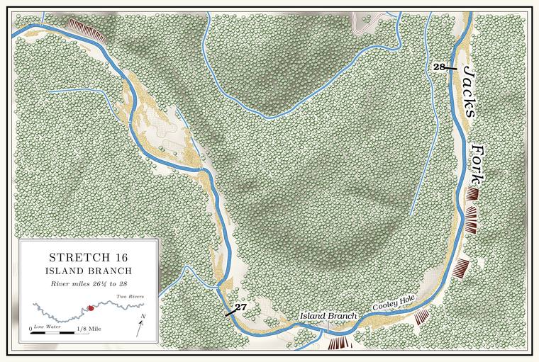
Flat Top Bluff stands on the left above the run east toward Island Branch. A spring with a pipe in it ran out at its upper end, and by 1980, after some dry years, it no longer ran all the time. The river used to divide along the bluff and make two islands. By 1980 the channel ran along the cut bank on the right. Watson Hole, wide and fairly shallow, lies along the lower end of the bluff, and it is said to be named for a family that lived on the farm to the rightLewis 1980, PDF p. 44, the only source; map PDF p. 43 (Boneyard Hollow, Flat Top Bluff and its spring, the hole below).. A little above the mouth of Island Branch, Island Branch Ford carried a road across the river to the old Buffington PlaceLewis 1980, PDF pp. 44, 47 (map), the only source..
Island Branch
Creek · right bank · about mile 27.1 · Plate A9
Around the next sharp bend Island Branch comes in on the right, unnoticed by most floaters. It drains about three square milesJacks Fork Creek Network 2026. from the south. A small spring is said to feed it a few hundred yards up the hollow and another about two miles farther up, and whiskey, by the same account, was once made up the hollow. The name comes, by one account, from a large islandLewis 1980, PDF p. 44, the only source. the river used to make where the hollow comes in.
Federal maps called this stream Allen Branch until the 2011 corrections, which moved the name Island Branch down to it from the stream at Bee HollowMBGN 2011; USGS GNIS (748570); see Chapter 18 and Reach F. (Reach F; Chapter 18). By 1980 the local name had been written down for this stream with the story of the islandLewis 1980, PDF pp. 44, 47 (map lettered “Island Branch” at this mouth)..
Cooley Hole and the ledge
Pool and bluff · right bank (bluff) · about miles 27.1 to 27.5 · Plate A9
The Cooleys once lived near the mouth of Island Branch, and the rocky hole below it is Cooley Hole. It used to be big and deep. Roy Cooley, the story goes, was cutting corn one day in the 1940s and went in to cool off, took cramps in his legs and drowned there. The bluff on the right below the mouth rises about 300 feetmeasured on the flood-mapping terrain (Heimann, Atkinson and High 2025; Map 13), the face on the right at about mile 27.26., and what looks from the river like a cave in it is said to be only a rock ledgeLewis 1980, PDF p. 44, the only source; map PDF p. 47 (“Cooley Hole”, “Shelter”)..
Grandma Rocks, the Buffington Place and Black Bill Lynch Ford
Rocks, old farm and ford · right bank (rocks), left bank (farm) · about miles 27.5 to 28.4 · Plate A9
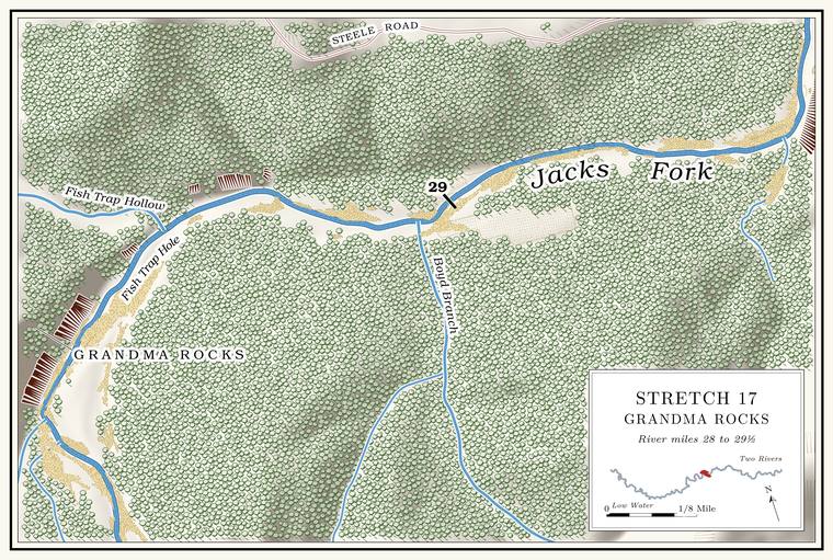
Below Cooley Hole the river runs north for about a mile through the Grandma Rocks Stretch, with the rocks on the rightPlate A9; Lewis 1980, PDF p. 47 (map).. At its lower end, just above the sharp right turn at Fish Trap Hollow, Grandma Rocks is mapped as a bar on the right side of the channelUSGS GNIS (736243, Bar), laid against the river centerline (28.41, right).. Across the river from the rocks, the bluff on the left rises about 350 feet, the tallest face on the rivermeasured on the flood-mapping terrain (Heimann, Atkinson and High 2025; Map 13), the face on the left at about miles 28.27 to 28.33 (about 347 feet), with a second face of about 310 feet just below it (28.37 to 28.43); see Chapter 2.. The stretch is said to have been named by Henry Younger. Seines were dropped around its flat rocks to catch fish, and this “Grandmaing. A hill word of the 1930s for stealing timber from public land or from absent owners and saying it came from “grandma’s” land (Chapter 7). Glossary →” for fish, by the same account, supplied the community fish friesLewis 1980, PDF p. 44, the only source; see Chapter 19. (Chapter 19). In 1977 a park folder picked out the deepening river after the sharp right turn through Grandma Rocks as a favorite fishing spotNPS 1977, stop 11 (“the deepening river after a sharp right turn through Grandma Rocks”)..
On the left, inside the long bend from Flat Top Bluff to Fish Trap Hollow, lay the old Buffington Place, where a small spring supplied the house with water. Two Ford. A place where a road crosses through the water. Many of the river’s fords took the names of the families who lived beside them (Chapter 8). Glossary → carried roads to it, the Island Branch Ford above and the Black Bill Lynch FordLewis 1980, PDF pp. 44, 47 (map), the only source. here, a little above the mouth of Fish Trap Hollow. The park has used the Buffington name for a camping place, apparently below Bay Creek, since at least 1981NPS 1981, 127 (the list ends “Bee Bluff to Bay Creek, Buffington’s”). (Places not yet placed).
Fish Trap Hollow and Fish Trap Hole
Hollow and pool · left bank · about mile 28.5 · Plate A9
After the long shallow run past Grandma Rocks the river turns sharply rightNPS 1977, stop 11; Plate A9. at the mouth of Fish Trap Hollow, which comes down from the northwest on the left. The hollow is about a mile and a third long and drains nearly two square milesJacks Fork Creek Network 2026 (2.2 km of traced channel; 1.8 sq mi).. A small spring enters the river from the foot of a small bluff on the left, and John Martin is said to have run a sawmillLewis 1980, PDF pp. 44, 47 (map, “Fish Trap Spring”, “Martin Sawmill”), the only source. at the mouth of the hollow.
The names probably recall the fish traps of pioneer days, when, by one account, they were common. Rocks and logs were laid in the river to stop the fish moving upstream, and the water was funneled over the swiftest spot. When someone wanted a mess of spring suckers and redhorse, they set a crate in the swift water above the obstruction. The fish swam over the obstruction into the crate and were trapped, and the crate was taken out and put in the bushesLewis 1980, PDF p. 44, the only source. That the names come from the traps is an inference; no source says so. until it was needed again. Missouri’s first full game and fish law, the Walmsley Law of 1905, banned fish traps on most of the state’s waters from July through March, along with gill nets, Gig, gigging. A gig is a spear of three or four barbed iron tines on a pole as much as fourteen feet long. Gigging is spearing fish with it from a boat in clear, shallow water, chiefly suckers, by night under lights or by day (Chapter 19). Glossary → and trotlinesRichards 2003 (the law excepted the Missouri and Mississippi rivers)..
Fish Trap Hole lies below a big rock on the left. It is said to be one of the deepest spots on the whole river, and in winter, when the water turns crystal clear, its sandy bottom could be seen nearly twenty feetLewis 1980, PDF p. 44, the only source. down. At low water it is about 8 feet deep today, among the deepest pools on the riverthe pool’s depth below the riffle that holds it, roughly its low-water depth, measured on the 2021–23 riverbed survey (Heimann, Atkinson and High 2025; Map 12; pool at about mile 28.62); the deepest named holes measure 8 to 10 feet.. An Eminence resident who has done park work knew Fish Trap Hole and Fish Trap Hollow by those names in 2026, and Boyd Branch and Rail Tree HollowJacks Fork Oral History, record SV-12. as well.
Boyd Branch and Joe Boyd Ford
Creek and ford · right bank · about miles 28.6 to 29.4 · Plate A9
Below Fish Trap Hole the river runs east, shallow and choppy, over a smooth bottom of solid rock. A boy is said to have drowned in the hole above the mouth of Boyd Branch in the 1800s and to be buried at the edge of the fieldLewis 1980, PDF pp. 44, 47 (map, “Grave”), the only source.. Boyd Branch comes in on the right at mile 29.0 and drains about a square mile and a halfJacks Fork Creek Network 2026 (28.95, right; 1.47 sq mi); USGS GNIS (748982).. By one account it held water knee deep for a quarter of a mile or so, and it runs water farther than that. It is named, by the same account, for the Boyds who owned the mill at AlleyLewis 1980, PDF p. 44, the only source. The mill passed to Ellen J. Boyd in 1895 (Lewis 1980, PDF p. 48); see Reach H. (Reach H).
Thornton “Fodder” Jones and Bill Dyer, the story goes, were riding home from a pie supper when their horse stopped near the Boyd house, below the mouth of the Branch. A small creek. The sense is American, on record from 1674 (Chapter 18). Glossary →, at a white, ghostly figure in the road ahead. Imaginations ran wild for a time, and when they looked into it later the ghost turned out to be a big gander hung in the fence. Joe Boyd FordLewis 1980, PDF pp. 44, 47 (map), the only source. crossed the river between Boyd Branch and Big Bend Hole.
Big Bend Hole and Rail Tree Hollow
Pool and hollow · right bank (hollow) · about miles 29.4 to 29.8 · Plate A9
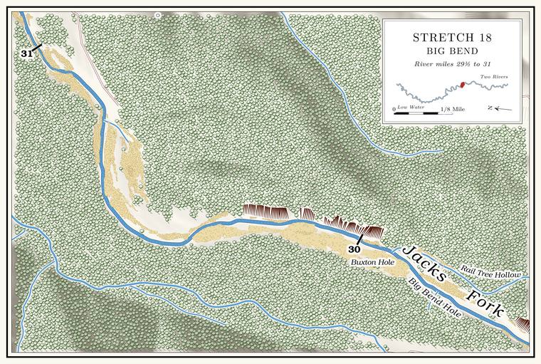
Just above Rail Tree Hollow the river makes a big bendLewis 1980, PDF pp. 44, 47 (map), the only source; Plate A9. from east to north under a bluff on the right that rises about 240 feetmeasured on the flood-mapping terrain (Heimann, Atkinson and High 2025; Map 13), the face on the right at about miles 29.5 to 29.6., and the pool in the bend is Big Bend Hole, about 8 feet deep at low waterthe pool’s depth below the riffle that holds it, roughly its low-water depth, measured on the 2021–23 riverbed survey (Heimann, Atkinson and High 2025; Map 12; pool at about mile 29.55).. Rail Tree Hollow comes in from the southeast on the right at about mile 29.7. It is a short hollow draining about half a square mileJacks Fork Creek Network 2026 (29.67, right; 0.46 sq mi); USGS GNIS (751799), whose point falls on the right of the river centerline at 29.69; Lewis 1980, PDF p. 47 (map, Railtree Hollow from the right)., and how it got its name has not been recorded. A second short hollow of the same size comes in on the left a little below, at about 29.8Jacks Fork Creek Network 2026 (29.83, left; 0.54 sq mi), which also files this channel under the Rail Tree Hollow name..
Buxton Hole and the Buxton farm
Pool and old farm · left bank (farm) · about mile 30.0 · Plate A9
Buxton Hole lies below Rail Tree Hollow, at the end of Buxton Lane, with the old Buxton farm on the left and a bluff of about 200 feet across the river on the rightmeasured on the flood-mapping terrain (Heimann, Atkinson and High 2025; Map 13), the faces on the right at about miles 30.0 to 30.3.. The story goes that Robert Powell moved onto the farm early in the 1860s, and that Lieutenant Boyd and the militia stopped at the house when Powell’s wife, Julianna, had just given birth to twin girls. The men carried the bed out into the yard with Julianna and the twins in it and burned the cabin. Neighbors took the mother and babies to the Union lines near Rolla, and the twins took pneumoniaLewis 1980, PDF pp. 44, 47 (map), the only source for this telling. and died. In November 1863 Lieutenant John W. Boyd’s patrol, having come to the river by the Leatherwood trail, went ten miles down the Jacks Fork to the Widow McCormick’sOR, vol. 22, pt. 1, 746–47; see Chapter 6., and two other tellingssee Chapter 6. of a Jacks Fork twins story are in Chapter 6.
William Buxton lived on the farm in the 1880s. In the winter of 1886, by one account, he gigged a ten-pound Jack salmon. The Ozark name for the walleye, a fish not collected in the Jacks Fork since 1980 (Chapter 9; Chapter 16). Glossary →Lewis 1980, PDF p. 44, the only source; see Chapter 19. near the farm (Chapter 19). Jack salmon was the Ozark name for the walleyesee Chapter 9., a fish not collected in the Jacks Fork since 1980MDC 2001; see Chapter 16. (Chapter 16). In the Current, walleye spend the day in pools twelve feet deep or more, where boulders or sunken logs break up the bottom, and move into shallower water at night. Grown walleye usually weigh from half a pound to about eight pounds, though bigger onesMDC, “Walleye.” turn up.
The last miles to Alley
Shallows and branch · about miles 30.0 to 31.3 · Plate A9
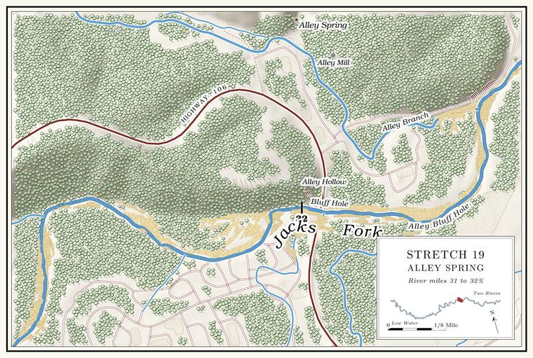
Below Buxton Hole the river runs north-northeast toward Alley through the widest and shallowestPlate A9; MDC 2003; see Chapter 20. water of the stretch. An unnamed branch of a little more than half a square mile comes in on the left at about mile 31.3Jacks Fork Creek Network 2026 (31.27, left; 0.58 sq mi).. In 1998 and 1999, about a mile and a quarter above Alley Spring, the river ran 5 to 25 meters wide, with pools more than 2 meters deep common between the Riffle. A fast, shallow, rocky stretch between pools. The riffles are the gardens of the riverbed: in July a square meter of riffle produced more than six times as much as a square meter of pool (Chapter 16). Glossary →, and chambersWhitledge and Rabeni 2000, 166; see Chapter 16. set on its bed measured how much the riffles and pools produced (Chapter 16). On Highway 106, about three-quarters of a mile west of Alley Spring, a road cut shows the contact between the Gasconade Dolomite and the Roubidoux FormationThornberry-Ehrlich 2016, 15 (1.2 km, citing Lowell and others 2010). above it.
Places not yet placed
Lower Bay Creek and Buffington’s. The park’s list of primitive campsites in 1981 ended “Bee Bluff to Bay Creek, Buffington’s,” and in 2022 the park named a Lower Bay Creek backcountry area and a Buffington primitive area, set after the Bay Creek campground and before AlleyNPS 2022a, E-6 and map C-11., apparently in downstream order. Neither has been placed on the ground. The Buffington name presumably comes from the old Buffington PlaceLewis 1980, PDF pp. 44, 47. inside the bend above Fish Trap Hollow.
Buxton Hollow. A map of 1980 brings Buxton Hollow down from the northwest toward Buxton Lane and the old Buxton farmLewis 1980, PDF p. 47 (map), the only source., on the left below Rail Tree Hollow. It is not on the federal mapsUSGS GNIS; Jacks Fork Creek Network 2026., and its stream has not been matched to a mapped channel.
Barton BayLewis 1980, PDF p. 47 (map), the only source.. The same map letters Barton Bay on the left in the last mile above Alley, one of the sloughs and baysLewis 1980, PDF p. 49. that once lined this part of the river. Most of them had filled in by 1980.
Alley Hill. A photograph of about 1980 looks upriver from Alley Hill toward Island BranchLewis 1980, PDF p. 46 (photograph caption, “Looking upriver from Alley Hill toward Island Branch”). The hill’s identification is an inference.. The hill is probably the one west of Alley where Highway 106 comes down to the river.
The photographs above Alley. The channel photographed about 1925 and again in 1992, and the field buried in gravel in the aerial photograph of November 1990, are described only as upstream from Alley SpringJacobson and Primm 1994, 35, 68, 71..
On to Reach H
Just below the last small branch on the left the river comes to the head of the Alley Spring Campground at about mile 31.3, where Reach H begins with Davis Ford, the campground’s river front and Bluff Hole above the Highway 106 bridgeLewis 1980, PDF pp. 47, 51 (maps), 49, 52; Jacks Fork Creek Network 2026 (unnamed branch, 31.27, left); see Reach H. The 1980 maps of this stretch meet at Davis Ford, in the shallow stretch flanked by the campground; laid on the river centerline, both put the ford at about mile 31.2, and the line between Reaches G and H is drawn just below the branch, at about 31.3.. Rules for the river are in Part Six.
| Creek | Bank | Mile | Drainage | Name |
|---|---|---|---|---|
| Dry Hollow | left | about 25.9 | 0.5 sq mi | local |
| Boneyard Hollow | left | about 26.3 | not traced | local |
| Island Branch | right | about 27.1 | 3.0 sq mi | federal map since 2011 (Allen Branch before) |
| Fish Trap Hollow | left | 28.5 | 1.8 sq mi | federal map |
| Boyd Branch | right | 29.0 | 1.5 sq mi | federal map |
| Rail Tree Hollow | right | 29.7 | 0.5 sq mi | federal map |
| Unnamed hollow | left | 29.8 | 0.5 sq mi | not the federal name |
| Unnamed branch | left | 31.3 | 0.6 sq mi | none |