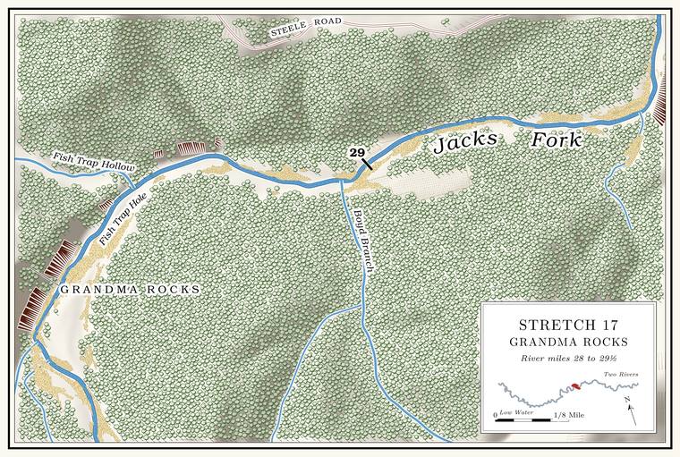
Fish Trap Hollow and Fish Trap Hole
Hollow and pool · left bank · about mile 28.5 · Plate A9
After the long shallow run past Grandma Rocks the river turns sharply rightNPS 1977, stop 11; Plate A9. at the mouth of Fish Trap Hollow, which comes down from the northwest on the left. The hollow is about a mile and a third long and drains nearly two square milesJacks Fork Creek Network 2026 (2.2 km of traced channel; 1.8 sq mi).. A small spring enters the river from the foot of a small Bluff. A cliff along the river, usually on the outside of a bend, where the river has cut sideways into the hill. In this sense the word was first used in North America (Chapter 2; Chapter 18). Glossary → on the left, and John Martin is said to have run a sawmillLewis 1980, PDF pp. 44, 47 (map, “Fish Trap Spring”, “Martin Sawmill”), the only source. at the mouth of the hollow.
The names probably recall the fish traps of pioneer days, when, by one account, they were common. Rocks and logs were laid in the river to stop the fish moving upstream, and the water was funneled over the swiftest spot. When someone wanted a mess of spring suckers and redhorse, they set a crate in the swift water above the obstruction. The fish swam over the obstruction into the crate and were trapped, and the crate was taken out and put in the bushesLewis 1980, PDF p. 44, the only source. That the names come from the traps is an inference; no source says so. until it was needed again. Missouri’s first full game and fish law, the Walmsley Law of 1905, banned fish traps on most of the state’s waters from July through March, along with gill nets, Gig, gigging. A gig is a spear of three or four barbed iron tines on a pole as much as fourteen feet long. Gigging is spearing fish with it from a boat in clear, shallow water, chiefly suckers, by night under lights or by day (Chapter 19). Glossary → and trotlinesRichards 2003 (the law excepted the Missouri and Mississippi rivers)..
Fish Trap Hole lies below a big rock on the left. It is said to be one of the deepest spots on the whole river, and in winter, when the water turns crystal clear, its sandy Bottom. The flat land along a river or creek, built of its deposits and open to its floods. In the 1920s the bottoms near Eminence averaged about a quarter of a mile wide (Chapter 2; Chapter 5). Glossary → could be seen nearly twenty feetLewis 1980, PDF p. 44, the only source. down. At Low Water. The local name for the Highway Y bridge over the South Prong, the access beside it and the county’s low-water crossing where the prongs meet, and so for the head of the river (Chapter 8; Chapter 18). Glossary → it is about 8 feet deep today, among the deepest Pool. A deep, slow stretch of river between riffles (Chapter 16). Glossary → on the riverthe pool’s depth below the riffle that holds it, roughly its low-water depth, measured on the 2021–23 riverbed survey (Heimann, Atkinson and High 2025; Map 12; pool at about mile 28.62); the deepest named holes measure 8 to 10 feet.. An Eminence resident who has done park work knew Fish Trap Hole and Fish Trap Hollow by those names in 2026, and Boyd Branch and Rail Tree HollowJacks Fork Oral History, record SV-12. as well.
Boyd Branch and Joe Boyd Ford
Creek and ford · right bank · about miles 28.6 to 29.4 · Plate A9
Below Fish Trap Hole the river runs east, shallow and choppy, over a smooth bottom of solid rock. A boy is said to have drowned in the Hole. Any pool deep enough to swim or fish in, named or not, the basic unit of the river in local speech; also “hole of water” (Chapter 18). Glossary → above the mouth of Boyd Branch in the 1800s and to be buried at the edge of the fieldLewis 1980, PDF pp. 44, 47 (map, “Grave”), the only source.. Boyd Branch comes in on the right at mile 29.0 and drains about a square mile and a halfJacks Fork Creek Network 2026 (28.95, right; 1.47 sq mi); USGS GNIS (748982).. By one account it held water knee deep for a quarter of a mile or so, and it runs water farther than that. It is named, by the same account, for the Boyds who owned the mill at AlleyLewis 1980, PDF p. 44, the only source. The mill passed to Ellen J. Boyd in 1895 (Lewis 1980, PDF p. 48); see Reach H. (Reach H).
Thornton “Fodder” Jones and Bill Dyer, the story goes, were riding home from a pie supper when their horse stopped near the Boyd house, below the mouth of the Branch. A small creek. The sense is American, on record from 1674 (Chapter 18). Glossary →, at a white, ghostly figure in the road ahead. Imaginations ran wild for a time, and when they looked into it later the ghost turned out to be a big gander hung in the fence. Joe Boyd FordLewis 1980, PDF pp. 44, 47 (map), the only source. crossed the river between Boyd Branch and Big Bend Hole.
Big Bend Hole and Rail Tree Hollow
Pool and hollow · right bank (hollow) · about miles 29.4 to 29.8 · Plate A9
Just above Rail Tree Hollow the river makes a big bendLewis 1980, PDF pp. 44, 47 (map), the only source; Plate A9. from east to north under a bluff on the right that rises about 240 feetmeasured on the flood-mapping terrain (Heimann, Atkinson and High 2025; Map 13), the face on the right at about miles 29.5 to 29.6., and the pool in the bend is Big Bend Hole, about 8 feet deep at low waterthe pool’s depth below the riffle that holds it, roughly its low-water depth, measured on the 2021–23 riverbed survey (Heimann, Atkinson and High 2025; Map 12; pool at about mile 29.55).. Rail Tree Hollow comes in from the southeast on the right at about mile 29.7. It is a short hollow draining about half a square mileJacks Fork Creek Network 2026 (29.67, right; 0.46 sq mi); USGS GNIS (751799), whose point falls on the right of the river centerline at 29.69; Lewis 1980, PDF p. 47 (map, Railtree Hollow from the right)., and how it got its name has not been recorded. A second short hollow of the same size comes in on the left a little below, at about 29.8Jacks Fork Creek Network 2026 (29.83, left; 0.54 sq mi), which also files this channel under the Rail Tree Hollow name..