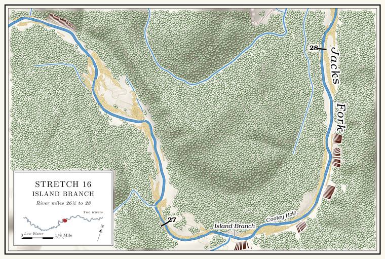
Flat Top Bluff, Watson Hole and Island Branch Ford
Bluff, pool and ford · left bank (bluff) · about miles 26.3 to 27.0 · Plate A9
Flat Top Bluff stands on the left above the run east toward Island Branch. A spring with a pipe in it ran out at its upper end, and by 1980, after some dry years, it no longer ran all the time. The river used to divide along the Bluff. A cliff along the river, usually on the outside of a bend, where the river has cut sideways into the hill. In this sense the word was first used in North America (Chapter 2; Chapter 18). Glossary → and make two islands. By 1980 the channel ran along the cut bank on the right. Watson Hole, wide and fairly shallow, lies along the lower end of the bluff, and it is said to be named for a family that lived on the farm to the rightLewis 1980, PDF p. 44, the only source; map PDF p. 43 (Boneyard Hollow, Flat Top Bluff and its spring, the hole below).. A little above the mouth of Island Branch, Island Branch Ford carried a road across the river to the old Buffington PlaceLewis 1980, PDF pp. 44, 47 (map), the only source..
Island Branch
Creek · right bank · about mile 27.1 · Plate A9
Around the next sharp bend Island Branch comes in on the right, unnoticed by most floaters. It drains about three square milesJacks Fork Creek Network 2026. from the south. A small spring is said to feed it a few hundred yards up the hollow and another about two miles farther up, and whiskey, by the same account, was once made up the hollow. The name comes, by one account, from a large islandLewis 1980, PDF p. 44, the only source. the river used to make where the hollow comes in.
Federal maps called this stream Allen Branch until the 2011 corrections, which moved the name Island Branch down to it from the stream at Bee Hollow (Reach F; Chapter 18). By 1980 the local name had been written down for this stream with the story of the islandLewis 1980, PDF pp. 44, 47 (map lettered “Island Branch” at this mouth)..
Cooley Hole and the ledge
Pool and bluff · right bank (bluff) · about miles 27.1 to 27.5 · Plate A9
The Cooleys once lived near the mouth of Island Branch, and the rocky Hole. Any pool deep enough to swim or fish in, named or not, the basic unit of the river in local speech; also “hole of water” (Chapter 18). Glossary → below it is Cooley Hole. It used to be big and deep. Roy Cooley, the story goes, was cutting corn one day in the 1940s and went in to cool off, took cramps in his legs and drowned there. The bluff on the right below the mouth rises about 300 feetmeasured on the flood-mapping terrain (Heimann, Atkinson and High 2025; Map 13), the face on the right at about mile 27.26., and what looks from the river like a cave in it is said to be only a rock ledgeLewis 1980, PDF p. 44, the only source; map PDF p. 47 (“Cooley Hole”, “Shelter”)..
Grandma Rocks, the Buffington Place and Black Bill Lynch Ford
Rocks, old farm and ford · right bank (rocks), left bank (farm) · about miles 27.5 to 28.4 · Plate A9
Below Cooley Hole the river runs north for about a mile through the Grandma Rocks Stretch, with the rocks on the rightPlate A9; Lewis 1980, PDF p. 47 (map).. At its lower end, just above the sharp right turn at Fish Trap Hollow, Grandma Rocks is mapped as a bar on the right side of the channelUSGS GNIS (736243, Bar), laid against the river centerline (28.41, right).. Across the river from the rocks, the bluff on the left rises about 350 feet, the tallest face on the rivermeasured on the flood-mapping terrain (Heimann, Atkinson and High 2025; Map 13), the face on the left at about miles 28.27 to 28.33 (about 347 feet), with a second face of about 310 feet just below it (28.37 to 28.43); see Chapter 2.. The stretch is said to have been named by Henry Younger. Seines were dropped around its flat rocks to catch fish, and this “Grandmaing. A hill word of the 1930s for stealing timber from public land or from absent owners and saying it came from “grandma’s” land (Chapter 7). Glossary →” for fish, by the same account, supplied the community fish friesLewis 1980, PDF p. 44, the only source; see Chapter 19. (Chapter 19). In 1977 a park folder picked out the deepening river after the sharp right turn through Grandma Rocks as a favorite fishing spotNPS 1977, stop 11 (“the deepening river after a sharp right turn through Grandma Rocks”)..
On the left, inside the long bend from Flat Top Bluff to Fish Trap Hollow, lay the old Buffington Place, where a small spring supplied the house with water. Two Ford. A place where a road crosses through the water. Many of the river’s fords took the names of the families who lived beside them (Chapter 8). Glossary → carried roads to it, the Island Branch Ford above and the Black Bill Lynch FordLewis 1980, PDF pp. 44, 47 (map), the only source. here, a little above the mouth of Fish Trap Hollow. The park has used the Buffington name for a camping place, apparently below Bay Creek, since at least 1981 (Places not yet placed).