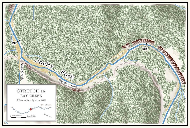
Dyer Bluff, George Dyer Bluff and Big Rock Hole
Bluffs and pool · both banks · about miles 25.0 to 25.7 · Plate A9
The big Bluff. A cliff along the river, usually on the outside of a bend, where the river has cut sideways into the hill. In this sense the word was first used in North America (Chapter 2; Chapter 18). Glossary → on the right, rimmed by the river where it turns north toward Bay Creek, is called Dyer Bluff. It rises about 310 feetmeasured on the flood-mapping terrain (Heimann, Atkinson and High 2025; Map 13), the faces on the right at about miles 24.7 to 25.1. above the water. What looks from below like a cave in it is said to be only a shelter, a disappointment to anyone who climbs the steep slopeLewis 1980, PDF p. 40, the only source; on the right: Lewis 1980, PDF p. 43 (map) and Plate A8 (bluff at about mile 25.0). to it.
George Dyer Bluff stands on the left between Bay Creek and the old George Dyer Place, above Big Rock Hole, and rises about 280 feetmeasured on the flood-mapping terrain (Heimann, Atkinson and High 2025; Map 13), the face on the left at about mile 25.5, beside Big Rock Hole on the 1980 map (PDF p. 43); a lower face of about 150 feet stands on the left just above the mouth of Bay Creek (about mile 25.8).. A rock on the bank, by one account, once stood six feet above the water there, and children dove off it into the Hole. Any pool deep enough to swim or fish in, named or not, the basic unit of the river in local speech; also “hole of water” (Chapter 18). Glossary →. By 1980 the rock could no longer be seenLewis 1980, PDF p. 40, the only source..
Bay Creek
Creek, landing and campground · left bank · about mile 25.9 · Plate A9
Bay Creek comes in on the left at the end of the reach. It drains about fifteen square miles of upland, but on the state’s stream maps only about a mile of its nine flows all yearMDC 2001, PDF 28–29 (table Ge03: 1.0 of 9.2 miles)., and in August 2006 it was adding half a cubic footMugel, Richards and Schumacher 2009, 27–28 (table 2). of water a second to the river. By one account it always runs water, though a floater hardly notices it, and its springs lie mostly in Watered Hollow, the fork of the creek that holds water; the Burk Heiney Spring, a big one, is said to rise below the mouth of Watered Hollow. Dry Hollow, which by the same account holds no visible water at all, comes down beside the creek at its mouth, and the road from Highway 106 came down it to the Joab Dyer PlaceLewis 1980, PDF p. 40, the only source.. The river used to swing to the right through what was called the Clay Bank Hole. By 1980 it ran straight past the mouth of the creek, and in normal water none flowed through the old channelLewis 1980, PDF p. 40 and the map on PDF p. 43, the only source; see Chapter 15. (Chapter 15).
The Park Service keeps a landing and a backcountry campground at Bay Creek, at the end of a gravel road from Highway 106NPS 2022a, E-6 to E-7 (Bay Creek Campground) and map C-11; NPS 1977, “Bay Creek”; see Chapter 11. (Chapter 11). Archaeologists checking the ground for park development around 1980 recorded prehistoric chipped stone, including large dart points, at Bay Creek, along with late-nineteenth-century ceramics and bottle glassLynott 1981, 74, 124–25; see Chapter 3. (Chapter 3). In April 2007 a party of cavers camped on a high Gravel bar. A bank of chert gravel and sand, usually on the inside of a bend, bare at low water (Chapter 15; Chapter 18). Glossary → about a hundred yards from the last of the Bay Creek campsites, across from a high, steep bluff “pockmarked with holes.” Around midnight one of them heard a large animal moving through the brush across the narrow river, perhaps Forty. Forty acres, a quarter of a quarter section. A hill farm was often one or two forties (Chapter 5). Glossary → feet away, and got a good enough look to be confident it was a small black bear. A black bear had been reported in the vicinity, and it frequently broke into coolers at the Bay Creek campgroundJohnson 2007, 33.. Black bears, rare in Missouri by the 1850s (Chapter 13), had nearly disappeared by the early 1900s, and by the 1930s and 1940s few if any were left. Between 1958 and 1968 Arkansas released 254 bears caught in Minnesota and Manitoba, bears began crossing north into Missouri, and by 2024 the state estimated about a thousand, increasing by about 8 percent a yearMDC 2025 (bears) (an estimate of 998 bears for 2024)..
The Joab Dyer Place stood on the hill between Bay Creek and Dry Hollow, and above the old home place, near the edge of the trees, thirty to forty graves make up the Dyer Cemetery, where Dyers, Donaldsons, Hardwicks, Ipocks, Stuarts, Coops and CookysLewis 1980, PDF p. 40, the only source. The scan prints “Stu1ut,” read as Stuart. are buried. About twenty families are said to have lived on Bay Creek, and the big flood of 1928 ruined most of their small farms (Chapter 14). By one account there were two sawmills on the creek. In that flood the mule barn at Kooler’s mill, about a mile and a half up, washed away, and drowned mules were found the next day scattered clear to the mouth of the creek. Cleve Hoberry and a man named Babcock had the other mill about three miles up, and Hoberry, Joab Dyer’s father-in-law, is said to have come from California. Another mill stood at Black PondLewis 1980, PDF p. 40, the only source; the June 1928 flood: see Chapter 14..
A sawyer born in 1914 who grew up near Bay Creek, and lived near it for forty-six years, remembered that people there held back from burning the woods to save the acorns for their hogsJacobson and Primm 1994, 40 (table 6), 45 (Jess Plowman); see Chapter 5. (Chapter 5). He also remembered “a lot of bays along the river, that the water come up but there wasn’t no current through it,” which disappeared when the drifts went out of the river. Where the creek’s name came from has not been recorded; another Bay Creek, on the Current, takes its name from Goose BayO’Brien 1939, 9.. In November 1863 ten Union militiamen came down Bay Creek to the Jacks Fork on the same patrolStevens 1991, 61–62; see Chapter 6. that came down Leatherwood (Chapter 6).
Dyer Ford, the castle bluff and Boneyard Hollow
Ford, bluff and hollow · left bank · about miles 25.9 to 26.3 · Plate A9
Dyer FordLewis 1980, PDF p. 43 (map, “Dyer Ford (Bay Creek)”), the only source; Joab Dyer Place: see Reach F. crossed the river at the mouth of Bay Creek, below the old Joab Dyer Place (Reach F). Below it a small bluff borders the river on the left between Dry Hollow, which comes down beside Bay CreekLewis 1980, PDF pp. 40, 43; Jacks Fork Creek Network 2026 (unnamed channel entering at 25.91, left); see Reach F. and holds no visible water, and Boneyard Hollow. In winter, by one account, three upright rocks jut out of the cliff like the fortifications of a castle. Boneyard Hollow is said to be named for a nearby farm that used it to dispose of dead farm animalsLewis 1980, PDF p. 40, the only source.. A slough called the Spring Bay began at its mouth. By 1980 the river had cut into the Spring Bay and it was gone, and thirty to forty feet had been cut off the left bank of the field below Bay CreekLewis 1980, PDF p. 44, the only source..