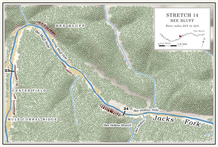
Center Field
Field · right bank · about mile 22.9 · Plate A8
Center Field lies on the right, in the sharp bendLewis 1980, PDF p. 40 and the map on PDF p. 43, the only source; Plate A8. the river makes around Bee Bluff.
Rough Hollow
Hollow · left bank · about mile 23.1 · Plate A8
Rough Hollow comes in on the left, draining nearly two square milesJacks Fork Creek Network 2026 (1.9 square miles); USGS GNIS (725594).. It is the second Rough HollowUSGS GNIS; see Reach E. on the upper river, after the one above Rymers (Reach E). It is said to run water for some distance and to be hard goingLewis 1980, PDF p. 40, the only source. on foot. The hollow is part of the Leatherwood Creek Natural area. A Missouri tract set aside as one of the best remaining examples of the state’s native communities, to be managed to keep it that way. The Jacks Fork and Barn Hollow natural areas were designated on May 27, 1980 (Chapter 11). Glossary →. By one account J. U. Woolsey lived on the ridgeLewis 1980, PDF p. 41, the only source. between Rough Hollow and Leatherwood.
Bee Bluff, Bee Bluff Hole and Spring Bluff Hole
Bluff and pools · left bank · about miles 23.3 to 23.5 · Plate A8
Bee Bluff stands on the outside of a hairpin bend, where the river turns from north to eastPlate A8; USGS GNIS (736242, left bank)., and rises about 240 feetmeasured on the flood-mapping terrain (Heimann, Atkinson and High 2025; Map 13), the face on the left at about miles 23.3 to 23.4.. In 1977 the park told floaters that honeybees’ homes could sometimes be seen in the Hole. Any pool deep enough to swim or fish in, named or not, the basic unit of the river in local speech; also “hole of water” (Chapter 18). Glossary → high in its uneven faceNPS 1977, stop 10., and George Ipock, by one account, took honey out of those holes with a long ladder. The Pool. A deep, slow stretch of river between riffles (Chapter 16). Glossary → beside the Bluff. A cliff along the river, usually on the outside of a bend, where the river has cut sideways into the hill. In this sense the word was first used in North America (Chapter 2; Chapter 18). Glossary → is Bee Bluff Hole. Below it is Spring Bluff Hole, about 6 feet deep at Low Water. The local name for the Highway Y bridge over the South Prong, the access beside it and the county’s low-water crossing where the prongs meet, and so for the head of the river (Chapter 8; Chapter 18). Glossary →the pool’s depth below the riffle that holds it, roughly its low-water depth, measured on the 2021–23 riverbed survey (Heimann, Atkinson and High 2025; Map 12; pool at about mile 23.57)., named for a small spring, with a pipeLewis 1980, PDF p. 40, the only source. said to carry water out of the spring. The old Forsite Place, said to have been homesteaded by a family named JustisLewis 1980, PDF p. 40, the only source., lay on the left below the bluff. The park’s list of primitive campsites in 1981 ran “Bee Bluff to Bay Creek.”
Bee Hollow Ford
Former crossing · about mile 23.9
Above Bee Hollow, by one account, Oscar and Adolf Kooler built a Low-water bridge, low-water crossing. A road crossing built low across a stream, a ford with a floor, often a concrete slab with culvert pipes beneath it, which water overtops in a rise (Chapter 8; Chapter 18). Glossary → in the logging days, with sides of logs filled with big rocks. A spring flood carried it away long ago, and the place is now called Bee Hollow FordLewis 1980, PDF p. 40, the only source..
Bee Hollow, Bee Hollow Branch and Bee Hollow Hole
Hollow, branch and pool · right bank · about mile 24.0 · Plate A8
Bee Hollow comes in from the south about seven-tenths of a mile below Bee Bluff, and its stream, Bee Hollow Branch, drains about a square mile and a halfJacks Fork Creek Network 2026 (1.5 square miles).. Both names have been official only since the 2011 corrections; before that the maps left the valley without a name and called its stream Island BranchMBGN 2011; USGS GNIS (748765, 2710695); see Chapter 18. (Chapter 18). The pool at the mouth is Bee Hollow HoleLewis 1980, PDF p. 43 (map); Plate A8.. In the logging days a Tram, tramway. A light logging railroad laid up a hollow, such as Cordz-Fisher’s line down Pine Hollow (Chapter 7). Glossary → of the Cordz-Fisher company is said to have come out of Pine Hollow into the head of Bee Hollow, the hollow below Bee Bluff, ending about a quarter of a mile from the river behind Chalk Bluff. It hauled logs to the mill at Birch Tree, with Pine knot. The base of a pine limb where it grows into the trunk, so full of resin that it outlasts the rest of a dead tree and burns hot and bright. Pine knots lit the gigging boats, burning in a fire box or metal basket called a firejack in the middle of the boat (Chapter 19). Glossary → piled along the route to fire the boilerLewis 1980, PDF pp. 34 (“the railroad came out of Pine Hollow and into Bee Hollow … to a point about one-fourth mile from the river,” told with the Iron Stake Woods behind Chalk Bluff) and 40 (the Cordz-Fisher tram “branched off into the upper part of Bee Hollow”), the only source; read together here as one tram. See Chapter 7. (Chapter 7).
Spring Hollow below Bee Bluff
Hollow · left bank · about mile 24.1
A little below Bee Hollow a hollow known as Spring Hollow comes in on the left, a different hollow from the Spring Hollow at the Kelly holes. A small spring rises in it, and a man named Leech is said to have made whiskey there, with the spring for water and dead cedar for fuel, since it burns with almost no smokeLewis 1980, PDF p. 40 and the map on PDF p. 43, the only source..
The Flat Hole and the tie yard
Pool and former tie landing · about miles 24.3 to 24.7
The Flat Hole lies between Bee Hollow and a hollow on the right known as Turkey Roost Hollow, which comes in at about mile 24.7, where the river begins its turn north toward Dyer BluffLewis 1980, PDF p. 43 (map: Turkey Roost Hollow entering on the right at the foot of the Flat Hole, above Dyer Bluff); Plate A8 (an unlettered right-bank stream at about mile 24.7); measured on the river centerline.. By one account it has filled in so badly that it is only a shallow stretch of water, slow and flat enough to take a long time to get through. Above it there is said to have been a tie yard, where ties were dropped into the river down a Chute. A narrow, fast slot of water through a shoal or past an obstacle. A smooth V of water pointing downstream marks the deepest path through it (Chapter 20). Glossary → (Chapter 7). Jabe Searcy’s cabin is said to have stood on the left. In 1980 the road along the north bank, which came in from Highway 106 by Bay Creek, ran upstream past the old George Dyer Place and the Forsite Place and climbed over the hill toward Bee Bluff. In 1977 the park described campsites strung along it down to Bay CreekNPS 1977, “Bay Creek.”, and in 2007 the road ran about two miles upriver from the campground with campsites scatteredJohnson 2007, 33. along the way. The river from Bay Creek up to the old Justis Place is by one account a favorite place to camp.