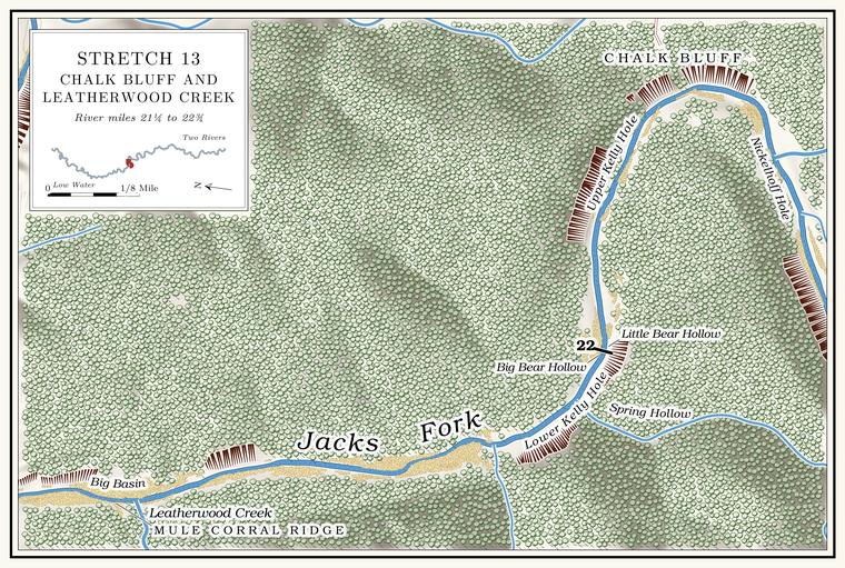
Stillhouse Hollow and Nickelhoff Hole
Hollow and pool · right bank · about mile 21.4 · Plate A7 (Nickelhoff Hole)
Stillhouse Hollow comes in from the south at the head of Chalk BluffJacks Fork Creek Network 2026 (mouth about 250 meters above the Chalk Bluff point); USGS GNIS (727109, 715702)., a valley three and a half miles longMBGN 2011. whose creek drains about four square milesJacks Fork Creek Network 2026 (4.0 square miles).. Until the 2011 corrections the federal maps called it Bee Hollow, and those corrections moved the Stillhouse name hereMBGN 2011; USGS GNIS (727109); see Chapter 18. The short valley that lost the name, lettered Stillhouse Hollow on USGS 1968 (Jam Up Cave), enters on the right at about mile 19.85, measured on the river centerline; MBGN 2011 gives it as 0.6 mile long, its name “verified by USGS fieldwork in 1968.” from a short valley on the same bank about a mile and a half upstream (Chapter 18). A park folder of 1977 told floaters that Chalk Bluff comes into view after they pass Still House HollowNPS 1977, stop 8.. By one account the hollow held one of the many whiskey stills along the Jacks Fork, supplied by a good spring a quarter of a mile upLewis 1980, PDF p. 34, the only source..
The Pool. A deep, slow stretch of river between riffles (Chapter 16). Glossary → at the mouth of the hollow is known as Nickelhoff HoleLewis 1980, PDF pp. 34, 37.. The hollow itself is “Nickelloff”Jacks Fork Oral History, record SV-23. to the angler, and the park’s list of primitive campsites in 1981 included a Nickeloff FieldNPS 1981, 127. on this stretch of the river.
Chalk Bluff
Bluff · right bank · about mile 21.6 · Plate A7
Chalk Bluff is the landmark of the reach, a long, high, paleLewis 1980, PDF p. 34 (“the white face of Chalk Bluff”). wall on the outside of a sharp bend to the leftNPS 1977, stop 8; Plate A7; USGS GNIS (715702, right bank).. Its face rises about 200 feet above the watermeasured on the flood-mapping terrain (Heimann, Atkinson and High 2025; Map 13), the face on the right at about miles 21.5 to 21.6; McKee 1996 also gives 200. The right-bank wall continues around the bend to about mile 21.85, where a face rises about 280 feet., though its height has also been given as about 120NPS 2015 (Chalk Bluff).. A floater of 1996 called it “whitish,” and below it found the river wider and lined with rolling hills. The water along the Bluff. A cliff along the river, usually on the outside of a bend, where the river has cut sideways into the hill. In this sense the word was first used in North America (Chapter 2; Chapter 18). Glossary → is known as the Chalk Bluff StretchLewis 1980, PDF p. 37 (map).. Nearly every bluff on the river is Dolomite. Calcium magnesium carbonate rock, a close relative of limestone, formed from lime mud on the floor of a warm, shallow sea. Nearly every bluff on the Jacks Fork is dolomite (Chapter 1). Glossary →see Chapter 1. (Chapter 1), and a park folder of 1977 took this one for chalkNPS 1977, stop 8..
A spring on the right above the bluff is said to flow over a round, solid rock, and another comes out at the edge of the gravel below it. That lower spring, by one account, was found to ebb and flow one day when two men, Fodder Jones and Carl Seaman, stopped there to eat lunch and watched it rise for about ten minutesLewis 1980, PDF p. 34, the only source; the lower spring is also listed among ebb-and-flow springs on PDF p. 30. and fall again. The angler marks a spring near the upper end of the bluffJacks Fork Oral History, record SV-23 (marked on a map at about mile 21.5, right bank)., and a resident who came to Mountain View from Oklahoma in 1979 knows of a spring at Chalk Bluff but could not mark whereJacks Fork Oral History, record SV-05 (“heard of it, not sure where”).. How such springs work is in Chapter 12.
The woods behind the bluff are known as the Iron Stake WoodsLewis 1980, PDF p. 34, the only source., said to be a good place to hunt, and named for a large iron stake driven into the ground in the logging days, when a Tram, tramway. A light logging railroad laid up a hollow, such as Cordz-Fisher’s line down Pine Hollow (Chapter 7). Glossary → reached the head of Bee Hollow behind the bluff (below).
The bluff belongs to the L-A-D Foundation, though it lies inside the national riverways. In late April 2015 someone spray-painted a patch of its face about 12 feet by 24. That June a man pleaded guilty in federal court and paid $4,097.96 in fines and restitution, and three volunteers from the Cave Research Foundation rappelled down the bluff and spent two days scrubbing the paint off with water, vinegar and wire brushes, finishing on June 29NPS 2015 (Chalk Bluff)..
The Kelly holes and Big and Little Bear hollows
Pools and hollows · left bank · about miles 21.8 to 22.3 · Plate A7
Around the bend from Chalk Bluff the river runs west past Upper Kelly Hole and turns north at Lower Kelly HolePlates A7 and A8.. Upper Kelly Hole is said to lie at the mouth of Big Bear Hollow and Lower Kelly Hole at the mouth of Little Bear Hollow, a short way below; both hollows come in on the leftPlate A7; USGS GNIS (726936, Spring Hollow).. By one account both Hole. Any pool deep enough to swim or fish in, named or not, the basic unit of the river in local speech; also “hole of water” (Chapter 18). Glossary → have filled with gravel, though Lower Kelly Hole is still about 10 feet deep at Low Water. The local name for the Highway Y bridge over the South Prong, the access beside it and the county’s low-water crossing where the prongs meet, and so for the head of the river (Chapter 8; Chapter 18). Glossary →, the deepest of the river’s named holesthe pool’s depth below the riffle that holds it, roughly its low-water depth, measured on the 2021–23 riverbed survey (Heimann, Atkinson and High 2025; Map 12; pool at about mile 22.17).. Big Bear is the hollow the federal maps call Spring Hollow, a short, rough and brushy hollow of a little over half a square mileJacks Fork Creek Network 2026 (0.6 square miles). with a large spring flowing out of the ground near the river, and the angler calls it “Big bear”Jacks Fork Oral History, record SV-23 (name given for Spring Hollow). too. Little Bear is also said to run waterLewis 1980, PDF p. 34 (“The Upper and Lower Kelly Holes are at the mouths of Big and Little Bear Hollows”), the only source; the pairing follows the order of that sentence and the map on PDF p. 37, which brings Spring (Big Bear) Hollow and Big Bear Spring to the river at the west end of Upper Kelly Hole, where the river begins to turn north, and aims Little Bear Hollow at the northward run below the turn. The mouth of Spring Hollow: USGS GNIS (726936), measured on the river centerline (22.08), where the river begins to turn north..
Leatherwood Creek
Creek · left bank · about mile 22.7 · Plate A8
Leatherwood Creek comes into the river on the left through a big Gravel bar. A bank of chert gravel and sand, usually on the inside of a bend, bare at low water (Chapter 15; Chapter 18). Glossary →Lewis 1980, PDF p. 34, the only source.. It is the largest side stream of the reach, about twelve miles long and draining about twenty square miles. The federal maps name Sugar Tree, Walnut and Dry hollows along its course, and its North Prong and South ProngJacks Fork Creek Network 2026 (19.5 kilometers; 20.1 square miles); USGS GNIS. join it far up the valley. By one account it heads at Oakside on Highway 17 and runs water all the way down, with many springsLewis 1980, PDF p. 41, the only source. along it. On the state’s stream maps its lowest five and a half miles flow all year, and the South Prong, more than seven miles long, has no permanent flowMDC 2001, PDF 28–29 (table Ge03: Leatherwood Creek 5.6 of 5.6 miles; South Prong Leatherwood Creek 0.0 of 7.4).. A man born in 1926 who fished up Leatherwood as a boy said in the early 1990s that “now there isn’t much water”Jacobson and Primm 1994, 56 (Will McVicker; 39–40, table 6). where he used to fish.
The name is said to have come from the early settlers, after the leatherwood that grew thickly on the north and east slopes along the creek. It is a low shrub, one of the first in the Ozarks to bloom, its pale yellow tubular flowers hanging in clusters on bare Branch. A small creek. The sense is American, on record from 1674 (Chapter 18). Glossary →, and its bark and branches are tough enough that, by the same account, Indians used them for baskets and for tyingLewis 1980, PDF p. 34, the only source.. It flowers in late March and April, before its leaves open, and the yellow tube of each flower is its calyx, since it has no petals. The twigs bend without breaking and can be tied in knots, settlers used them as withes for binding, and the stems went into cordage, baskets and sandals. Every part of the plant is bitter, and the bark can blister some people’s skinMDC, “Eastern Leatherwood” (Dirca palustris), which also puts the shrub on north- and east-facing valley slopes, as the 1980 account does..
In April 2025 the state made 1,440 acres of the valley the Leatherwood Creek Natural Area, on land of the L-A-D Foundation, which manages it through the Pioneer Forest that Leo Drey founded in 1951. Drey had begun buying Cutover. Land from which the timber has been cut. The lumber companies left much of the Jacks Fork country cutover by about 1920 (Chapter 7). Glossary → Ozark timberland that year, and when he learned in 1953 that some 90,000 acres belonging to National Distillers were to be clear-cut, he went to New York and arranged to buy them. He cut his forest by single-tree selection, taking trees one at a time and leaving the stand, set up the L-A-D Foundation in 1962, and in 2004 he and his wife gave the Pioneer Forest to the foundation. When he died in 2015, at ninety-eight, it covered about 143,000 acres in six Missouri countiesSt. Louis Public Radio 2015. The year of the first purchases is Drey’s own (Drey 1998, 3: “1951, I bought the first land”), and the state gives the forest’s founding as 1951 (above); the obituary dates them to 1950. See Chapter 10.. Upstream the creek cuts through Roubidoux sandstone, and toward the mouth it winds between steep bluffs of Gasconade Dolomite, with as much as 400 feet from the valley floor to the ridgetops. Cliff, forest, Woodland. The period of prehistory from about 600 B.C. to A.D. 900 in radiocarbon years, when people here first made pottery and took up the bow (Chapter 3). Glossary → and fen hold more than 500 native plants, some of them Glacial relict. A plant left from a colder time, surviving on cool, damp cliffs, such as the harebell of the Jacks Fork Natural Area (Chapter 1; Chapter 16; Reach E). Glossary → more at home in the Great Lakes states that hang on in the Ozarks on steep, sheltered north-facing slopes, and darters and other fish that need clean water live in the creek. The Natural area. A Missouri tract set aside as one of the best remaining examples of the state’s native communities, to be managed to keep it that way. The Jacks Fork and Barn Hollow natural areas were designated on May 27, 1980 (Chapter 11). Glossary → has no facilitiesMDC, Leatherwood Creek Natural Area.. In 1977 the park pointed floaters to the creek mouthNPS 1977, stop 9; see Chapter 16. to see the mix of eastern, southern and western plants (Chapter 16).
A lot of families once lived along Leatherwood, and by one account Loss Millman had a sawmill about three miles upLewis 1980, PDF p. 41, the only source. the creek in 1928. John Woolsey is said to have lived on Leatherwood before the Civil War, and the trail named for him ran from his home up the creek and over the ridges to his brother’s place on the North Prong (Reach A). He is probably buried, by the same account, in a field on the point between Leatherwood and Rough Hollow, where six to twelve graves include one of a man named LinkLewis 1980, PDF p. 41, the only source; the graveyard is marked “Cem.” on the map, PDF p. 37. Woolseys buried on the North Prong: see Reach A.. In November 1863 a Union patrol came down to the river by Woolsey’s trail and burned the cabin of Miles and Jack StephensStevens 1991, 61–62, quoting the Official Records; see Chapter 6., by one account near the mouth of the creekLewis 1980, PDF p. 34, the only source for the place. (Chapter 6). Peter Renfro, who killed a Summersville constable in 1888, is said to have hidden in a cave on LeatherwoodLewis 1980, PDF p. 41; MSS 1982, 46, 49; see Chapter 13. (Chapter 13).
Up the valley a ridge above the creek is called the Mule Corral, with a sawmill said to have stood nearby, and a large Sinkhole. A hollow in the ground where rock below has dissolved or caved in, through which water drains underground; also called a sink, an American use (Chapter 2; Chapter 12). Glossary → called the Big Basin lies across from Low Gap, the gap between the South Prong and Walnut HollowLewis 1980, PDF p. 41 and the map on PDF p. 38, the only source.. On the upland between the lower creek and the river lies the Dogwood Basin, in country known as the Tin Roof, after a shed a cattleman was building whose tin was stolenLewis 1980, PDF p. 41 and the map on PDF p. 37, the only source. before he could finish it. Leatherwood is said to have been a good place to make whiskeyLewis 1980, PDF p. 41, the only source., and Harley Patterson, by one account the best whiskey maker on the upper Jacks Fork, made good whiskey and a lot of it. The creek is also known for cottonmouths, and some people will swear that a stick thrown into it will be mobbed by them. The snake itself, and the river’s other cottonmouth stories, are in Chapter 16.