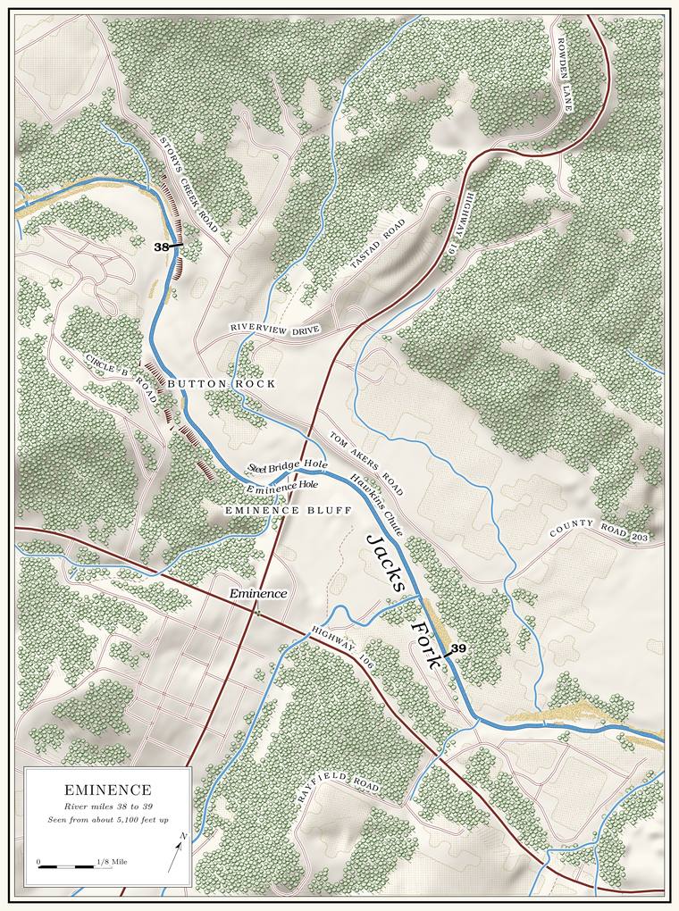
Below Storys Creek the Jacks Fork swings south around a tight loop past Button Rock and the Circle B campground and comes to the Highway 19 bridge at Eminence, the one town on its banksPlate A12.. It runs southeast past the town, turns north at about mile 39.5 under a string of named Pool. A deep, slow stretch of river between riffles (Chapter 16). Glossary →, bends east at the Hole-in-the-Wall and winds east-northeast for three miles past Kell Bluff, Powell Spring and Jones Bluff. Shawnee Creek and Little Shawnee Creek come in from the right, the last creeks of any size. Below them the river turns north again, swings east along the Garr Town Stretch and meets the Current at the JunctionPlates A12 and A13; Lewis 1980, PDF pp. 66, 77 (maps); the river centerline traced for the maps in this book (the channel heads south-southeast at mile 38.0, north from about 39.6 to 40.6, southeast at 41.0, north again from 44.0 to 44.6 and east-southeast at 45.0–45.2).. Through this reach the river falls about 5 feet a milethe river profile measured on the 2021–23 riverbed survey (Heimann, Atkinson and High 2025; Map 12); see Chapter 2.. Eminence to the mouth is the second half of the lower river’s standard float, a little under eight milessee Chapter 20 (Eminence to Two Rivers, 7.7 measured miles). (Chapter 20).
By here the river carries Alley Spring and Mahans Creek, and it grows little in its last eight miles. In the dry week of August 2006 it was carrying 133 cubic feet of water a second at Eminence and 138 at the mouth, and Shawnee Creek was adding a little under fiveMugel, Richards and Schumacher 2009, 27–28 (table 2; Shawnee Creek 4.8 cubic feet a second); see Chapter 12. (Chapter 12). From a couple of miles above Eminence to the Current the river runs in stretches on the Potosi Dolomite, the oldest rock in its bed. The town stands inside the western part of the Eminence Caldera. The basin left when an eruption empties the magma chamber beneath a volcano and the ground above it collapses. The Eminence caldera, about a billion and a half years old, lies around the meeting of the Jacks Fork and the Current (Chapter 1). Glossary →, a volcano that collapsed nearly a billion and a half years ago, and near the mouth Knob. The old Missouri name for a hill of hard volcanic rock, such as those near Eminence and the mouth (Chapter 1). Glossary → of its welded Tuff. Rock made of volcanic ash. Where the ash was still hot when it came to rest, the grains welded together into hard rock (Chapter 1). Glossary → rise within a few hundred yards of the riversee Chapter 1. (Chapter 1).
The wide Terrace. A level bench above a river, the remains of an older floodplain left high when the river cut down (Chapter 2). Glossary → at the creek mouths drew people early. A burned house of the Mississippian period was excavated on a terrace of the lower river, and the bench above the confluence has given up tools from the earliest timessee Chapter 3. on the river (Chapter 3). By 1840 a few settlers lived at the mouth, and the Chiltons and their neighbors farmed the terraces from Shawnee and Little Shawnee creeks up to the site of the townStevens 1991, 26–27; see Chapter 5. (Chapter 5). Near Eminence the river runs outside the national riverways, in the gap the law of 1964see Chapter 10. left around the town, and below it the park resumes (Chapter 10). The Trail ride. An organized gathering of hundreds or thousands of horseback riders, camping for several days and riding the trails and river crossings. The trail rides grew into a large business on the lower Jacks Fork (Chapter 11). Glossary →, the bacteria studies of the lower river and the Shawnee Creek band of wild horsessee Chapters 11 and 17. all belong to this stretch (Chapters 11 and 17).
The miles in the headings are counted from the junction of the Prong. A branch or arm of a creek, set down in 1860 as Southern usage. The North and South Prongs join to form the Jacks Fork (Chapter 18). Glossary → along the surveyed channel. The Highway 19 bridge is at mile 38.55, Lick Log Hollow at 40.9, Shawnee Creek at 43.5, Little Shawnee Creek at 43.9 and the meeting with the Current at 46.21the river centerline traced for the maps in this book, with the place register’s positions for the Highway 19 crossing and the confluence and the creek mouths of Jacks Fork Creek Network 2026.. Left and right are as you face downstream. The river turns often here. The left bank is the north bank where it runs east, and the west bank where it runs north, from about 39.5 to 40.8, from 44.0 to 44.7 and in the last half milethe river centerline..
Bend by bend
Button Rock and Circle B
Bluff and pool · left bank (bluff) · about mile 38.0 · Plate A12
Below Storys Creek the next Hole. Any pool deep enough to swim or fish in, named or not, the basic unit of the river in local speech; also “hole of water” (Chapter 18). Glossary → is Button Rock, deep, and long a favorite swimming hole of local people. The pool lies at about mile 38.0, where the river turns from east to southLewis 1980, PDF p. 69 (“Circle B Campground, located across the river”), map PDF p. 66 (Buttin Rock lettered on the left side between the river’s turn below Storys Creek and the bridge); Jacks Fork Oral History, records SV-12 and SV-20 (Button Rock pinned on the river at about miles 38.0 and 38.1) and SV-20 (Circle B pinned on the right bank at about mile 37.95); the river centerline (east-southeast at mile 37.9, south at 38.1); Plate A12 (Circle B Road and the campground inside the loop; a bluff drawn on the left at the outside of the bend, below Storys Creek Road); see Chapter 18 (“the jumping rock across from Circle B”). toward the town, and the rock is on the left, on the outside of the bend, where the Bluff. A cliff along the river, usually on the outside of a bend, where the river has cut sideways into the hill. In this sense the word was first used in North America (Chapter 2; Chapter 18). Glossary → rises about 90 feetmeasured on the flood-mapping terrain (Heimann, Atkinson and High 2025; Map 13), the face on the left at about miles 37.9 to 37.95, at the outside of the bend., across the river from the Circle B campground inside the loop. In town it was the boys’ hole, known to old-timers as the Naked HoleGibson 2000, 41; see Chapter 19. (Chapter 19), and its spelling is still unsettled, Button or Buttinsee Chapter 18. (Chapter 18). By one account William Jones caught a large otterLewis 1980, PDF p. 69, the only source. there in the winter of 1886 (the river’s otters are in Chapter 16), and a car once rolled across the road on the hill above the bluff and plunged down to the edge of the water; the woman driving it survived. The federal maps give the name Buttin Rock to a cliff about 110 feet highmeasured on the flood-mapping terrain (Heimann, Atkinson and High 2025; Map 13), the faces on the right at about miles 38.2 and 38.33 to 38.37. on the right bank about a quarter mile farther downUSGS GNIS (Buttin Rock, cliff, 715135, at about mile 38.3, right bank, about 65 meters from the channel)., on the campground’s side of the river. The state’s Buttin Rock Access, about ten acresMDC 2016 (Buttin Rock Access), 3–4 (9.68 acres; year of initial acquisition 1995; leased to the City of Eminence in January 2012). bought in 1995 and leased to the city of Eminence in 2012, carries the rock’s name.
Asked whether the river had moved between Button Rock and Eminence over the years, an Eminence resident who has done park work answered, “A little wandering from the floods.”Jacks Fork Oral History, record SV-12.
Steel Bridge Hole, Eminence Bluff and the bridge
Pool, bluff and bridge · right bank (bluff) · about miles 38.3 to 38.55 · Plate A12
Below Button Rock the river runs southeast to the Highway 19 bridge at mile 38.55. The pool above the bridge is Steel Bridge Hole, named for the town’s first bridge, and Eminence Bluff stands beside it on the town side. It is a different pool from the Steel Bridge hole at Highway 17see Reach C., far upriver (Reach C). When the first settlers came, by one account, the river divided here, and a smaller channel ran along the hillside and rejoined the main one a mile below.
By the same account the Eminence Ford was often impassable in high water, and in the summer of 1916 the town set out to get a bridge. Local people gave $3,000, the county court matched it, and the Canton Bridge Company finished a narrow steel-framed bridge in March 1917. It was soon too narrow. Work on a concrete bridge for the new Highway 19 began in February 1934, and it was finished in 1935Lewis 1980, PDF p. 69, the only source.. The present bridge dates from 2002see Chapter 8. (Chapter 8).
The flood of March 1904, by one account the largest anyone remembered, crested at Eminence at 27 feet. In April 2017 the river rose to 27.72, more than a foot and a half above the level at which water stands on the deck of the bridgesee Chapter 14 (the deck is reached at 26 feet). (Chapter 14).
The Eminence riverfront
Town, landings, chute and ford · right bank (town) · about miles 38.55 to 38.9 · Plate A12
Eminence lies on the right bank, the second county seat of that name, moved here from the Current after the warLewis 1980, PDF p. 64; see Chapter 5. (Chapter 5). Below the bridge the river runs southeast past the town through Hawkins Chute, named by one account, like Orchard Bay, Kell Bluff and McCabe Hollow below it, for people who once lived along the river. On the right the state keeps a one-acre public landing by agreement with its owner, the Joshua T. Chilton Memorial Landing, near the junction of Highways 19 and 106MDC, Joshua T. Chilton Memorial Landing., and floaters long took out at the Lions Ball ParkMDC 2003; see Chapter 20., a quarter mile below the bridge (Chapter 20). In 2010 the state’s Conservation Commission approved a contract to build an access at the Eminence city park, with a boat ramp, a canoe ramp, parking and restrooms, and the city was to clear away the park’s bleachers and cook shackMDC 2010 (approved August 20, 2010; the City of Eminence and the department as partners under the department’s Community Assistance Program; estimated cost $353,846.51, three-quarters from the federal Sport Fish Restoration Program).. The Chilton landing is probably that access, on the old ball park’s groundan inference. The release names neither the river nor the landing. The landing is a one-acre area run under a cooperative agreement with an owner the department does not name, on the north side of Highway 106 less than a tenth of a mile east of the Highway 19 junction (MDC, Joshua T. Chilton Memorial Landing); the float guide’s take-out was the ball park a quarter mile below the bridge on the right (MDC 2003); and the release’s bleachers fit a ball park..
From Eminence the guides of the Bales Boating Company took their Johnboat. A long, narrow, flat-bottomed, square-ended boat, poled, paddled or motored. It was the guide boat of the Eminence outfitters and is still the fishing and gigging boat of the river. The word is in print from 1894 (Chapter 9; Chapter 18). Glossary → parties down the Jacks Fork and the Current from 1928see Chapter 9. (Chapter 9), and by one account the company had a large boat ramp on the far side of the river. A generation of Eminence children learned to swim in the river from Luther Rowlett, who called himself a “Retriever”Gibson 2000, 41–42; see Chapter 19. (Chapter 19). The Cross-Country Trail Ride has camped on private land along the river in the gap around the town since 1981see Chapter 11. (Chapter 11).
A creek of about two square miles comes in on the right at about mile 38.9Jacks Fork Creek Network 2026 (2.03 square miles, mouth at 38.89, right, unnamed)., probably the Town Branch that a map of 1980 runs north through the west side of townLewis 1980, PDF p. 66 (map); the match is an inference. to the river. The Eminence Ford crossed below the ball park. On a low hill above the river on the town side lies the Old Eminence Cemetery, on ground Daniel Dye gave in 1873, where by one account two-year-old Cora Dye was the firstLewis 1980, PDF p. 64, the only source. The source lists about eighty family names and puts about two hundred graves there. burial. Cora Bell Dye lived from August 21, 1871, to September 21, 1873, and Daniel E. Dye, her father by one family record, died in 1884Shannon County cemetery readings (Old Eminence Cemetery: Daniel E. Dye, March 18, 1841–March 1, 1884; the parentage is the compiler’s note).. In the winter of 1876Lewis 1980, PDF pp. 69, 68 (the account runs from the foot of one page to the head of the other), the only source., by one account, James Chilton, a son of Joshua Chilton, and Ezekial Miller tried to cross the Ford. A place where a road crosses through the water. Many of the river’s fords took the names of the families who lived beside them (Chapter 8). Glossary → in high water. Chilton’s horse crossed easily. Miller’s threw him into the river, and he was swept downstream and drowned.
Across the river from the old ford lies the Chilton Cemetery, well kept and still in useLewis 1980, PDF p. 71; map PDF p. 66. in 1980. Joshua Chilton’s farm lay across and down the river, by one account (Chapter 6), and in 1939 people remembered a vanished village called ChiltonsvilleO’Brien 1939, 27., named for him, across the river from the town.
Old River Bay and the turn north
Pools and campground · right bank (campground) · about miles 39.2 to 39.7 · Plate A13
Below the town the river runs east, and at about mile 39.5 it turns north. At the turn a map of 1980 letters Old River BayLewis 1980, PDF p. 66 (map), the only source.. The Jacks Fork Campground lies on the rightPlate A13. here, the old Pickin’ and Grinnin’, a favorite riverside hangout of Eminence young people in the late 1990sGibson 2000, 75; see Chapter 19. (Chapter 19). Beside the campground a small creek of a little over half a square mile comes in on the right at about mile 39.4Jacks Fork Creek Network 2026 (an unnamed right-bank branch of 1.46 square kilometers at about mile 39.44); Plate A13 draws it entering at the campground.. Leaning Sycamore Hole comes next, about 7 feet deep at Low Water. The local name for the Highway Y bridge over the South Prong, the access beside it and the county’s low-water crossing where the prongs meet, and so for the head of the river (Chapter 8; Chapter 18). Glossary →, and High Bank Hole below it, about 5the pool’s depth below the riffle that holds it, roughly its low-water depth, measured on the 2021–23 riverbed survey (Heimann, Atkinson and High 2025; Map 12; pools at about miles 39.54 and 39.59).. The leaning sycamore that named the upper hole was a stump by 1980.
Orchard Bay, the Coppermine hollows and Cut Bank Hole
Bay, hollows and pool · about miles 39.9 to 40.6 · Plate A13
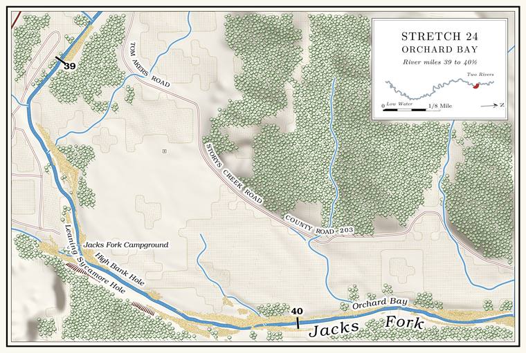
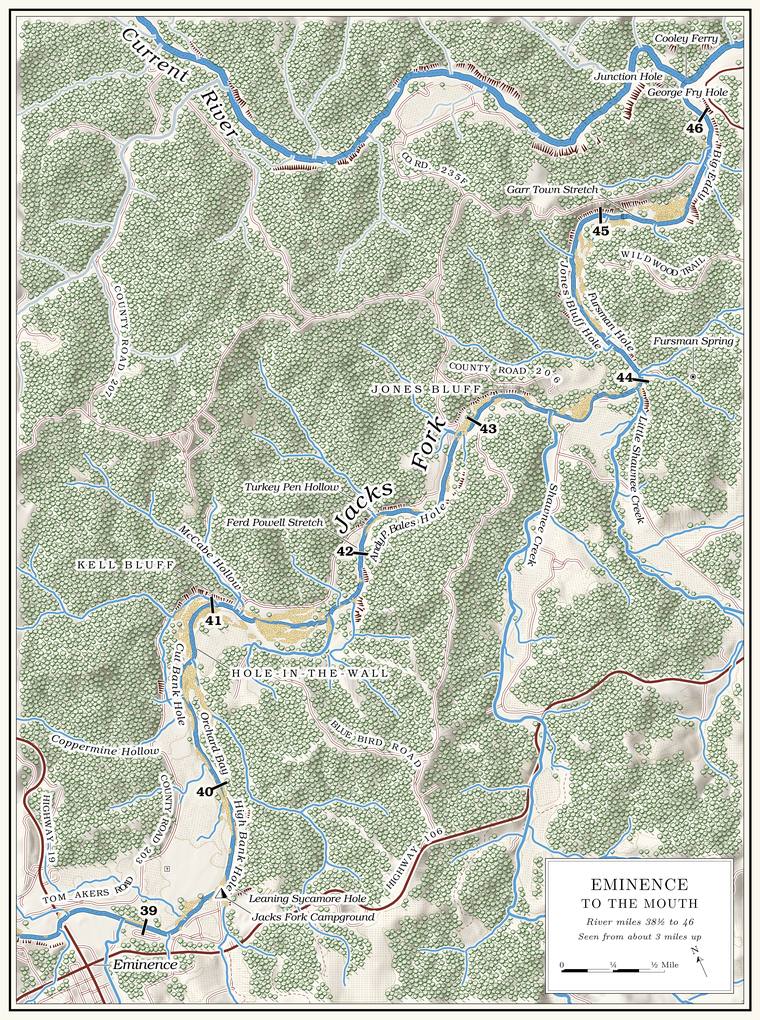
The river runs north for about a mile and a quarterthe river centerline (about miles 39.5 to 40.8).. Orchard Bay lies on the rightLewis 1980, PDF p. 66 (map); Plate A13. at about mile 40.0, where a short hollow of about three-quarters of a square mileJacks Fork Creek Network 2026 (0.73 square miles, mouth at 40.01, right, unnamed). comes in from the southeast. Two hollows here carry the name Coppermine. By one account the one on the east bank runs toward Coppermine Flats and the old Slater diggings and the one on the west bank toward the Casey Mine. The federal maps give the name to the western one, a short valley of less than half a square mile that comes in on the left at about mile 40.4USGS GNIS (Coppermine Hollow, valley, 716304); Jacks Fork Creek Network 2026 (0.45 square miles, mouth at 40.43, left).. By the same account it was also called Council Hollow, said to be where the Shawnee held their councils (Chapter 4), and in later years a man named Gates ran a sawmill in it. The coppersee Chapter 5. that named both hollows is told in Chapter 5.
A map of 1980 letters FallsLewis 1980, PDF p. 66 (map), the only source. a little below Orchard Bay, and below that lies Cut Bank Hole, a long pool about 4 feet deep at low waterthe pool’s depth below the riffle that holds it, roughly its low-water depth, measured on the 2021–23 riverbed survey (Heimann, Atkinson and High 2025; Map 12; pool at about mile 40.56)., with a high yellow clay bank on the right. The crossing just above Lick Log Hollow, with its big Gravel bar. A bank of chert gravel and sand, usually on the inside of a bend, bare at low water (Chapter 15; Chapter 18). Glossary →, is a trail-ride crossing where boaters and swimmers stop to picnic. In the bacteria studies of 2000 to 2004 it lay outside the park boundary, and as many as 500 horses an hourDavis and Barr 2006; see Chapter 17. crossed there on ride days (Chapter 17).
Lick Log Hollow and the Hole-in-the-Wall
Hollow, bluff and pool · left bank · about miles 40.9 to 41.1 · Plate A13
Lick Log Hollow comes in on the left at about mile 40.9, at the top of the bend where the river turns from north to southeastthe river centerline (north at 40.8, southeast at 41.0).. It drains about three-quarters of a square mileJacks Fork Creek Network 2026 (0.73 square miles, mouth at 40.87, left); USGS GNIS (Lick Log Hollow, valley). and is said to be named for an early deer Lick. A spot where animals come to lick salt or salty earth, an American word from 1751 (Chapter 18). Glossary →. By one account water runs in it, and at one point it flows through a set of Shut-in. A narrow, rocky gorge where a stream cuts through hard rock (Chapter 2). Glossary → in Granite. A coarse-grained rock made of magma that cooled slowly underground. Granite near Big Spring has been dated at about 1.46 billion years (Chapter 1). Glossary → rock, and Slater’s miners took some copper out of its upper part (Chapter 5). The Hole-in-the-Wall is the bluff and pool at its mouth, on the outside of the bendLewis 1980, PDF p. 66 (map, Hole-in-the-Wall lettered from the mouth of Lick Log Hollow, at the top of the bend, along the left bank of the run below it to the mouth of Kell Hollow).. The bluff rises about 90 feet just below the mouthmeasured on the flood-mapping terrain (Heimann, Atkinson and High 2025; Map 13), the face on the left at about miles 41.00 to 41.09, tallest at its upstream end. It is the only face of 50 feet or more on either bank between Cut Bank Hole and the low bluff at the mouth of Bald Knob Hollow, and it lies along the run the 1980 map letters Hole-in-the-Wall., and an old photographLewis 1980, PDF p. 67 (“Hole-In-The-Wall Bluff and Hole”). shows it standing over still water. The old Barnesville Road ran down the river past it. An Eminence resident who has done park work placed the Hole-in-the-Wall at the mouth of the hollowJacks Fork Oral History, record SV-12 (marked on a map beside the mouth of Lick Log Hollow, at about mile 40.9)..
McCabe Hollow and Kell Bluff
Hollow and bluff · left bank · about miles 41.1 to 41.3 · Plate A13
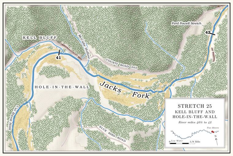
A quarter mile below, McCabe Hollow comes in from the north, a valley of about two-thirds of a square mileJacks Fork Creek Network 2026 (0.68 square miles, mouth at 41.12, left); USGS GNIS (McCabe Hollow, valley, 722029).. A map of 1980 calls the hollow at this place Kell HollowLewis 1980, PDF p. 66 (map). and gives the name Jim McCabe Hollow to the hollow at Powell SpringLewis 1980, PDF p. 74 (“Powell Spring is at the mouth of Jim McCabe Hollow”); map PDF p. 77., a mile and a half downstream. Kell Bluff stands on the left a little below the Hole-in-the-WallLewis 1980, PDF pp. 66 (map, Kell Bluff lettered on the left below the mouth of Kell Hollow, where the river turns from south to east, with the dotted Barnesville Road drawn between the lettering and the river), 75 (named for former residents); the river centerline (Lick Log Hollow at 40.87, McCabe Hollow at 41.12, south-southeast at 41.15–41.2 and east-southeast from 41.25). The place is read from a sketch map and is approximate., with the old Barnesville Road between it and the riverthe 1980 map. Kell Bluff is probably low or set back from the water: on the flood-mapping terrain no face of 50 feet or more rises within about 150 feet of the water on the left from 41.1 to 41.4 (Heimann, Atkinson and High 2025; Map 13). Another reading takes Kell Bluff for the lower end of the Hole-in-the-Wall face, which reaches nearly to the mouth of McCabe (Kell) Hollow; the 1980 map and photograph caption (“Hole-In-The-Wall Bluff”) keep the two names apart., probably just below the mouth of the hollow at about mile 41.2, where the river swings from south-southeast to east-southeast.
Turkey Pen Hollow, Bald Knob Hollow and the Ferd Powell Stretch
Shoal, hollows, stretch and pool · about miles 41.6 to 42.4 · Plate A13
Below Kell Bluff the river runs southeast for half a mile and turns northeastthe river centerline (about miles 41.0 to 41.6).. A rough Shoal. A fast, shallow, rocky stretch between pools; a riffle. Suckers crowd onto the shoals in spring, and the old saying is that “the dogwoods bloom when the suckers are shoaling” (Chapter 18; Chapter 19). Glossary →, with rounded Dolomite. Calcium magnesium carbonate rock, a close relative of limestone, formed from lime mud on the floor of a warm, shallow sea. Nearly every bluff on the Jacks Fork is dolomite (Chapter 1). Glossary → bedrock jutting up through the water, marks the stretch above Turkey Pen Hollow, which comes in on the right at about mile 41.7Lewis 1980, PDF p. 77 (map, Turkey Pen Hollow from the south at the shoal). with a good spring seeping out of its mouth. The hollow is said to take its name from a turkey pen, a box trap of rails baited with corn, with a trench dug under one side. The turkeys walked in through the trench and tripped a trigger tied to a door.
Bald Knob Hollow comes in on the left at about mile 42.2, a short hollow of about half a square mileJacks Fork Creek Network 2026 (0.54 square miles, mouth at 42.20, left); USGS GNIS (Bald Knob Hollow). with a low bluff at its mouth. A map of 1980 marks a spring thereLewis 1980, PDF p. 77 (map, “Spring” at the mouth of Bald Knob Hollow)., and whiskey is said to have been made in the hollow. The Ferd Powell Stretch runs along the left bank here, with the old river road between it and the bluff. Below it lies Andy P. Bales Hole, deep by one account of 1980, with a big rock at its lower end. Andy P. Bales was probably Andrew Powell Bales, of the Eminence family of David L. Bales and the Bales Boating Companyan inference from the name. Shannon County cemetery readings (Old Eminence Cemetery) list an Andrew Powell Bales, and David L. Bales and Mae Estelle Powell, as parents of children buried there; Lewis 1980, PDF p. 68 (David L. Bales, and his son Walter’s Bales Boating Company); see Chapter 9. (Chapter 9).
Powell Spring
Spring and ford · left bank · about mile 42.6 · Plate A13
Powell Spring comes out at the mouth of a short hollow on the left at about mile 42.6Lewis 1980, PDF p. 74 (“at the mouth of Jim McCabe Hollow”), map PDF p. 77 (north bank, between Andy P. Bales Hole and Jones Bluff Hole); the river centerline.. It was once the Andy Chilton Spring, and the old Barnesville RoadLewis 1980, PDF p. 75; map PDF p. 77 (“Ford”). forded the river here. By one account Alex Chilton killed two Union soldiers near the spring during the war, and on March 25, 1879, his uncle Andy Chilton gunned him down at the same spot. Faced with having killed a local hero, Andy Chilton had to leave the country, and he settled in Whitney, TexasLewis 1980, PDF p. 74, the only source.. He was probably not the Alexander Chilton killed on the Rolla road in 1862Lewis 1980, PDF p. 74 (the 1879 Alex Chilton was Andy Chilton’s nephew); see Chapter 6 (an Alexander Chilton among the prisoners killed on August 30, 1862). (Chapter 6).
A Shannon County man remembered walking with his grandfather, as a boy of eight or nine, down to the mouth of Big Shawnee and “back up Jack’s Fork about a mile to Powell Springs,” where they set sycamore polesGibson 2000, 42; see Chapter 19. along the bank and slept beside them all night (Chapter 19). Someone who grew up in Eminence lists “Powell Springs (River split)”Jacks Fork Oral History, record SV-15. among the river’s names that outsiders might not know.
Jones Bluff
Bluff and pool · left bank · about miles 42.7 to 43.2 · Plate A13
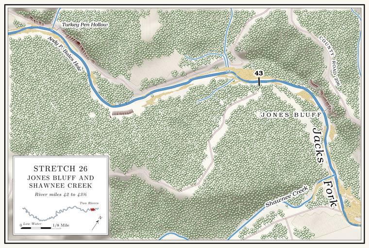
Below Powell Spring lies Jones Bluff Hole, under Jones Bluff on the left, which rises about 110 feetmeasured on the flood-mapping terrain (Heimann, Atkinson and High 2025; Map 13), the face on the left at about miles 43.20 to 43.25, the only face on the left between Powell Spring and Shawnee Creek.. It is named for Henry Clay Jones (1845–1916Shannon County cemetery readings (Chilton Cemetery: Henry Clay Jones, June 7, 1845–November 8, 1916, “Married; (Susan Chilton)”).), who married Susan Chilton, Joshua Chilton’s daughter. A small spring flows out at the river’s edge along the bluff. An old photograph shows the hole in winterLewis 1980, PDF p. 78 (“The Jones Bluff Hole during winter”)., a long sheet of water under a wooded bluff. Below the bluff the river runs southeast for the last quarter milethe river centerline (about miles 43.25 to 43.48). to Shawnee Creek.
Shawnee Creek
Creek · right bank · mile 43.5 · Plate A13
Shawnee Creek, also called Big Shawnee, comes in from the south at mile 43.5. It is the largest creek on the lower river, draining about twenty square miles, and runs about ten miles northMDC 2001, PDF 28–30 (table Ge03, 9.9 miles total, 8.5 permanent, fourth order); the creek network traces about 8.4 miles. to the river, all year in about its lower eight and a half. Its upper course comes down Black Valley and South HollowJacks Fork Creek Network 2026 (19.97 square miles, mouth at 43.48, right); USGS GNIS (Shawnee Creek, stream, mouth at 43.45).. Hay Hollow, its largest Branch. A small creek. The sense is American, on record from 1674 (Chapter 18). Glossary →, was in 1939 a valley “from which grass is cut for hay”Jacks Fork Creek Network 2026 (4.15 square miles); see Chapter 18. (Chapter 18).
The two Shawnee creeks carry the name of the Shawnee who were in this country early in the nineteenth centurysee Chapter 4. (Chapter 4). By one account a band of them lived on Shawnee Field, the Bottom. The flat land along a river or creek, built of its deposits and open to its floods. In the 1920s the bottoms near Eminence averaged about a quarter of a mile wide (Chapter 2; Chapter 5). Glossary → between the two creeks, and the creeks’ names are the only trace of their stay. By 1840 a Colonel Thomas Chilton farmed at the mouth of this one (Chapter 5), and Joseph Slater’s cabin and copper furnacesee Chapter 5. stood up the creek.
Up the creek, by one account, George N. DeatherageLewis 1980, PDF p. 79, the only source., known as Rumsey, ran a mill built by the millwright John C. McCaskill that was better known for its poker game and corn liquor than for the wheat and corn it ground. In the tie-cutting days there was a tie yard at its mouth. The story is told that after the war a farmer found the bones of two men killed on the creek, outlaws or Union soldiers. Nelson Chilton, Joshua Chilton’s son, is said to have escaped the Federals with a wounded arm in 1864Lewis 1980, PDF p. 79, the only source. The source calls his companion “his brother Joshus (son of Thomas Coot Chilton)”; “a kinsman” follows the parenthesis. Union patrols: see Chapter 6. and to have been killed later, with a kinsman, when they met a patrol on the road up Big ShawneeO’Brien 1939, 14; Lewis 1980, PDF pp. 74, 79. (Chapter 6).
At the mouth the park keeps the Shawnee Creek campground, a backcountry camp with a staging areasee Chapter 11. for riders (Chapter 11). Visitors there often meet the Shawnee Creek bandsee Chapter 11. of wild horses, which ranges along the lower river toward Two Rivers (Chapter 11). A water-quality station on the river above the creek’s mouth has been sampled since 1973MDC 2001, PDF 82; see Chapter 17. (Chapter 17).
Little Shawnee Creek and Fursman Spring
Creek, spring and mill sites · right bank · about miles 43.9 to 44.0 · Plate A13
Little Shawnee Creek comes in from the south at about mile 43.9, less than half a mile belowthe river centerline (43.48 and 43.91). Shawnee Creek. It drains about nine and a half square miles down Slick Rock, Despain and Odell hollowsJacks Fork Creek Network 2026 (9.35 square miles, mouth at 43.91, right); USGS GNIS (Little Shawnee Creek, mouth at 44.04). and runs about six miles, all year in nearly fourMDC 2001, PDF 28–30 (table Ge03, 6.0 miles total, 3.8 permanent, third order); the creek network traces about 5.1 miles. miles of it. In 1939 it was said to be “named for the Indians who lived along the banks.” By one account Thomas DentLewis 1980, PDF pp. 74, 79, the only source., from North Carolina by way of Tennessee, moved to a farm near the mouth after the Civil War and built a small water-powered gristmill on the creek, and his son Hiram ran it until the early 1900s. A flour mill of Hiram Dent’s was on the creek in 1901. By 1980 no sign of it was left.
About three miles up are Betheny Chapel and its cemetery, the chapel named for Bethenia Hawkins Adair, the wife of Henry Lee Adair, who settled on the creek in the 1840s. The cemetery began as the Adair family’s burying ground and by 1980 held more than 250 graves. The Little Shawnee SchoolLewis 1980, PDF p. 74; O’Brien 1939, 76 (“near Jack’s Fork”). stood about a mile and a half up the creek, and a post office called Shawnee served the creek from 1891 to 1918O’Brien 1939, 120; see Chapter 5. (Chapter 5). By one account John Chilton, taken by a Union patrol, was brought home to Little Shawnee, allowed to see his family and then shot.
On the right below the mouth of Little Shawnee, back from the riverUSGS GNIS (Fursman Spring, 718299, about 400 meters from the river at about mile 44.0, right)., Fursman Spring flows from under a small bluff and runs into a small lake down its ravine. By one account the Fursmans lived there in the Depression. A map drawn from the federal surveyors’ notes of 1821 and 1840 shows a mill beside a spring near the mouth of Little ShawneeStevens 1991, 36 (“Central Shannon County Settlement Pattern 1840,” after Clendenen 1973)., probably the mill later called the Fursman Spring MillStevens 1991, 27, 34; see Chapter 5. (Chapter 5), and at one time a sawmill stood up the hollow from the spring. By one account Sam West built a new cabin near the spring in 1861. When riders came looking for him during the war, he hid under the bed and then fired on them, and they killed his father, John West, and mortally wounded his wife (Chapter 6).
Fursman Hole and the run north
Pool and bluff · right bank (bluff) · about miles 44.0 to 44.6 · Plate A13
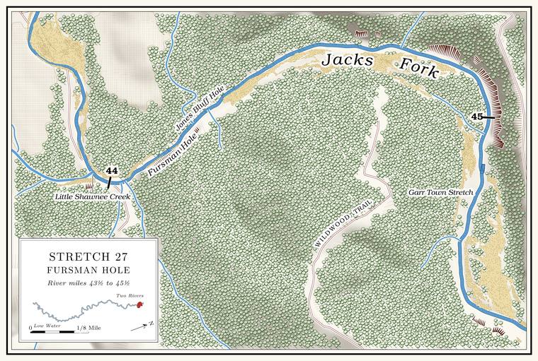
Below Little Shawnee the river turns north for about two-thirds of a milethe river centerline (about miles 44.0 to 44.7).. Fursman Hole, about 5 feet deep at low waterthe pool’s depth below the riffle that holds it, roughly its low-water depth, measured on the 2021–23 riverbed survey (Heimann, Atkinson and High 2025; Map 12; pool at about mile 44.09)., lies just below the creek mouth next to a bluff on the right that rises about 80 feetmeasured on the flood-mapping terrain (Heimann, Atkinson and High 2025; Map 13), the face on the right at about miles 44.11 to 44.18, the only face on either bank of the north run.. An unnamed hollow of about half a square mile comes in on the left at about mile 44.3Jacks Fork Creek Network 2026 (0.48 square miles, mouth at 44.28, left)..
The Garr Town Stretch
Stretch and spring · about miles 44.8 to 45.4 · Plate A13
At about mile 44.8 the river swings eastthe river centerline. along the Garr Town Stretch, also written Gar TownLewis 1980, PDF pp. 77 (map, “Garr Town Stretch”), 79 (“The Gar Town Stretch”); Plate A13., under a bluff on the left at about mile 45Plate A13. that rises about 160 feet, the tallest face on the river below Alleymeasured on the flood-mapping terrain (Heimann, Atkinson and High 2025; Map 13), the faces on the left at about miles 44.8 to 45.05; see Chapter 2.. The stretch is said to be named for the gar that once stayed along it in numbers, and a good spring comes out of a small hollow above it. The gar most likely here is the longnose, the most widespread gar in Missouri and the commonest gar of clear Ozark streams. It keeps to the larger, deeper pools and slow backwaters, often basks near the surface and commonly grows to about three feet, and from early May to mid-June it moves onto shallow gravelly Riffle. A fast, shallow, rocky stretch between pools. The riffles are the gardens of the riverbed: in July a square meter of riffle produced more than six times as much as a square meter of pool (Chapter 16). Glossary →MDC, “Longnose Gar.” The longnose is the only gar on the river’s fish list (see Chapter 16), so that the gar of the stretch were longnose is a likely inference. to spawn. By one account the wife of Doss Chilton, who lived on the ridge between the Current and the Jacks Fork, killed with a club a mountain lion her dogs had attacked, and killed a deer by rolling a large rock onto it from a bluff. The last known native mountain lion in Missouri was killed in the Bootheel in 1927MDC, Mountain Lions in Missouri..
George Fry Hole
Pool and spring · right bank (bluff) · about miles 45.8 to 46.0 · Plate A13
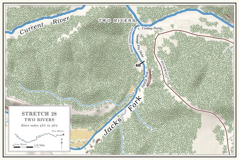
Below the Garr Town Stretch the river turns northeast and then norththe river centerline (about miles 45.4 to 46.0)., and a small branch comes in on the left at about mile 45.6Plate A13; the branch drains less than a square kilometer and is not in the creek network.. The last pool above the mouth is George Fry Hole, flanked by a low bluff on the right, with a slick rock spring below it. It is named for a captain in the Civil War who lived nearby. George Fry’s mother was a Galbraith, and by one account he and the Galbraiths owned the mill at the Junction.
The Junction
Confluence, pool, mill and ferry · mile 46.21 · Plate A13
The Jacks Fork meets the Current at mile 46.21the place register.. The place has carried several names: the Junction, Jack’s Fork for its post office, Coot Bay, and Two RiversLewis 1980, PDF p. 79; Klinger and Kandare 1987, 19; see Chapter 18., the name most people use now (Chapter 18). Just below the meeting, in the CurrentLewis 1980, PDF p. 79 (the confluence “is just above” the hole); map PDF p. 77; the motorboat of 1913 ran up the Current from Chilton to Coot Bay (PDF p. 80)., lies the deep, swirling Junction Hole, the Big EddyLewis 1980, PDF p. 77 (map, “Big Eddy / Coot Bay” lettered on the Current at the confluence). of a map of 1980. It was once much larger and was called Coot Bay, for Thomas “Coot” Chilton, who lived a short way down the Current. By one family record he was Thomas Boggs Chilton, and his daughter Elizabeth (1822–1899) married Joshua ChiltonShannon County cemetery readings (Chilton Cemetery: Elizabeth Chilton, October 15, 1822–March 31, 1899, with the compiler’s note “Daughter of Thomas Boggs ‘Coot’ Chilton & Rebecca Daniels. Married Joshua Chilton”). The same readings also give Joshua’s father as a Thomas Boggs, “cousin to Thomas Coot,” so the compilers do not keep the two Thomases clearly apart.. By one account, in June or July of 1876, with the Current running full, men from a lumber camp swam across the muddy river and back. Someone called to John Buffington, halfway across, to let down and show how deep it was. He went down and did not come up, and his body was found eleven days later a mile downstream. In 1986 a man who knew the place told archaeologists that a hole thirty feet deep at the confluence had filled with gravel to about fourKlinger and Kandare 1987, 37; see Chapter 3. (Chapter 3).
By one account John Hyer built a water-powered sawmill at the Junction about 1880. It passed to Galbraith and Fry and in 1887 to the Current River Land and Cattle Company. Known as the Junction Mill or the Galbraith Mill, it could saw about 40,000 feet of lumber a day and was said to sell the best lumber in the countyLewis 1980, PDF p. 79, the only original source; repeated in Klinger and Kandare 1987, 19.. Before the war, by one account, William Shedd, a Vermonter, kept a store at the Junction for a time (Chapter 5). By one account a Union army camped here in February 1863 on its march to Pilot Knob, and two state militiamen, or two renegades, were killed while camped at the Junction (Chapters 6 and 8). From 1913 a motorboat ran between Coot Bay and Chilton, on the Current, and a post office called Jack’s Fork served the settlement from about 1917 to 1954Lewis 1980, PDF pp. 79, 80; see Chapter 8. (Chapter 8).
Bertha Hunt came to the Jacks Fork community at the age of six, in 1912, when her parents rented and then bought land at the mouth. Ties stacked by the river were rafted each fall down the Current to Chicopee, below Van Buren (Chapter 7). In 1925 she married a carpenter named Russell, and in 1927 they bought the place. The Russells secured the right-of-way for the road that became Highway V; before it, the only way to Eminence was a wagon road that crossed the river about six times (Chapter 8). They built six tourist cabins along the bank and, in 1935, a log store that also held the post office, which she kept for ten years. They rented johnboats and outfitted Float trip. A trip down the river by boat, from a few hours to several days, with a way back arranged at the end (Chapter 20). Glossary →, and her husband, who built his own motors and boats, kept a johnboat tied on each side of the river as a ferry for the neighbors. Below the present store, she said, there had been rich bottom land, since washed away. The Park Service took the buildings down after it acquired the land.
A map of 1980 puts the Junction Landing and Cooley Ferry on the CurrentLewis 1980, PDF pp. 77 (map), 78 (photograph, “The Junction or John Cooley Ferry”). just below the meeting, and the old ferry crossing noted there in 1977NPS 1977, panel 2; see Chapter 8. crossed the Current (Chapter 8). The park’s campground and landing at Two Rivers stand on the bench above the Currentsee Chapters 3 and 11. (Chapters 3 and 11), and the recommended Put-in, take-out. The places where a float begins and ends (Chapter 20). Glossary →MDC 2003; see Chapter 20. is about three-quarters of a mile down the Current, at the old ferry landing (Chapter 20). By one account the hill across the river is made of reddish Rhyolite. A volcanic rock at least 72 percent silica, the rock of the knobs near Eminence and the mouth. Much of the rhyolite here is tuff (Chapter 1). Glossary →, and its leaves turn pale yellow in midsummer because the rock holds moisture less well than Limestone. Calcium carbonate rock formed from lime mud and shells on a sea floor. Most of the limestone laid down here later became dolomite (Chapter 1). Glossary → or dolomite (Chapter 1).
Into the Current
At the Junction the Jacks Fork, with Alley Spring and Blue Spring in it, goes into the Current, about forty-six milesthe river centerline (46.21). from the junction of its prongs. The Current carries it on past Owls Bend and Van Burensee Chapters 8 and 14.. Rules for the river are in Part Six.
| Creek | Bank | Mile | Drainage | Name |
|---|---|---|---|---|
| Unnamed (probably Town Branch) | right | about 38.9 | 2.0 sq mi | Town Branch on a map of 1980 |
| Unnamed | right | about 39.4 | 0.6 sq mi | — |
| Unnamed | right | about 40.0 | 0.7 sq mi | — |
| Coppermine Hollow | left | about 40.4 | 0.45 sq mi | federal map |
| Lick Log Hollow | left | 40.9 | 0.7 sq mi | federal map |
| McCabe Hollow | left | 41.1 | 0.7 sq mi | federal map (Kell Hollow on a map of 1980) |
| Bald Knob Hollow | left | 42.2 | 0.5 sq mi | federal map |
| Shawnee Creek | right | 43.5 | 20.0 sq mi | federal map |
| Little Shawnee Creek | right | 43.9 | 9.4 sq mi | federal map |
| Unnamed | left | about 44.3 | 0.5 sq mi | — |