George Fry Hole
Pool and spring · right bank (bluff) · about miles 45.8 to 46.0 · Plate A13
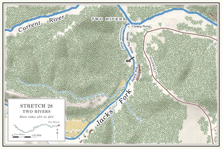
Below the Garr Town Stretch the river turns northeast and then norththe river centerline (about miles 45.4 to 46.0)., and a small Branch. A small creek. The sense is American, on record from 1674 (Chapter 18). Glossary → comes in on the left at about mile 45.6Plate A13; the branch drains less than a square kilometer and is not in the creek network.. The last Pool. A deep, slow stretch of river between riffles (Chapter 16). Glossary → above the mouth is George Fry Hole, flanked by a low Bluff. A cliff along the river, usually on the outside of a bend, where the river has cut sideways into the hill. In this sense the word was first used in North America (Chapter 2; Chapter 18). Glossary → on the right, with a slick rock spring below it. It is named for a captain in the Civil War who lived nearby. George Fry’s mother was a Galbraith, and by one account he and the Galbraiths owned the mill at the Junction.
The Junction
Confluence, pool, mill and ferry · mile 46.21 · Plate A13
The Jacks Fork meets the Current at mile 46.21the place register.. The place has carried several names: the JunctionLewis 1980, PDF p. 79; Klinger and Kandare 1987, 19; see Chapter 18., Jack’s Fork for its post office, Coot Bay, and Two Rivers, the name most people use now (Chapter 18). Just below the meeting, in the CurrentLewis 1980, PDF p. 79 (the confluence “is just above” the hole); map PDF p. 77; the motorboat of 1913 ran up the Current from Chilton to Coot Bay (PDF p. 80)., lies the deep, swirling Junction Hole, the Big EddyLewis 1980, PDF p. 77 (map, “Big Eddy / Coot Bay” lettered on the Current at the confluence). of a map of 1980. It was once much larger and was called Coot Bay, for Thomas “Coot” Chilton, who lived a short way down the Current. By one family record he was Thomas Boggs Chilton, and his daughter Elizabeth (1822–1899) married Joshua ChiltonShannon County cemetery readings (Chilton Cemetery: Elizabeth Chilton, October 15, 1822–March 31, 1899, with the compiler’s note “Daughter of Thomas Boggs ‘Coot’ Chilton & Rebecca Daniels. Married Joshua Chilton”). The same readings also give Joshua’s father as a Thomas Boggs, “cousin to Thomas Coot,” so the compilers do not keep the two Thomases clearly apart.. By one account, in June or July of 1876, with the Current running full, men from a lumber camp swam across the muddy river and back. Someone called to John Buffington, halfway across, to let down and show how deep it was. He went down and did not come up, and his body was found eleven days later a mile downstream. In 1986 a man who knew the place told archaeologists that a Hole. Any pool deep enough to swim or fish in, named or not, the basic unit of the river in local speech; also “hole of water” (Chapter 18). Glossary → thirty feet deep at the confluence had filled with gravel to about fourKlinger and Kandare 1987, 37; see Chapter 3. (Chapter 3).
By one account John Hyer built a water-powered sawmill at the Junction about 1880. It passed to Galbraith and Fry and in 1887 to the Current River Land and Cattle Company. Known as the Junction Mill or the Galbraith Mill, it could saw about 40,000 feet of lumber a day and was said to sell the best lumber in the countyLewis 1980, PDF p. 79, the only original source; repeated in Klinger and Kandare 1987, 19.. Before the war, by one account, William Shedd, a Vermonter, kept a store at the Junction for a time (Chapter 5). By one account a Union army camped here in February 1863 on its march to Pilot Knob, and two state militiamen, or two renegades, were killed while camped at the Junction (Chapters 6 and 8). From 1913 a motorboat ran between Coot Bay and Chilton, on the Current, and a post office called Jack’s Fork served the settlement from about 1917 to 1954Lewis 1980, PDF pp. 79, 80; see Chapter 8. (Chapter 8).
Bertha Hunt came to the Jacks Fork community at the age of six, in 1912, when her parents rented and then bought land at the mouth. Ties stacked by the river were rafted each fall down the Current to Chicopee, below Van Buren (Chapter 7). In 1925 she married a carpenter named Russell, and in 1927 they bought the place. The Russells secured the right-of-way for the road that became Highway V; before it, the only way to Eminence was a wagon road that crossed the river about six times (Chapter 8). They built six tourist cabins along the bank and, in 1935, a log store that also held the post office, which she kept for ten years. They rented Johnboat. A long, narrow, flat-bottomed, square-ended boat, poled, paddled or motored. It was the guide boat of the Eminence outfitters and is still the fishing and gigging boat of the river. The word is in print from 1894 (Chapter 9; Chapter 18). Glossary → and outfitted Float trip. A trip down the river by boat, from a few hours to several days, with a way back arranged at the end (Chapter 20). Glossary →, and her husband, who built his own motors and boats, kept a johnboat tied on each side of the river as a ferry for the neighbors. Below the present store, she said, there had been rich Bottom. The flat land along a river or creek, built of its deposits and open to its floods. In the 1920s the bottoms near Eminence averaged about a quarter of a mile wide (Chapter 2; Chapter 5). Glossary → land, since washed away. The Park Service took the buildings down after it acquired the land.
A map of 1980 puts the Junction Landing and Cooley Ferry on the CurrentLewis 1980, PDF pp. 77 (map), 78 (photograph, “The Junction or John Cooley Ferry”). just below the meeting, and the old ferry crossing noted there in 1977NPS 1977, panel 2; see Chapter 8. crossed the Current (Chapter 8). The park’s campground and landing at Two Rivers stand on the bench above the Currentsee Chapters 3 and 11. (Chapters 3 and 11), and the recommended Put-in, take-out. The places where a float begins and ends (Chapter 20). Glossary →MDC 2003; see Chapter 20. is about three-quarters of a mile down the Current, at the old ferry landing (Chapter 20). By one account the hill across the river is made of reddish Rhyolite. A volcanic rock at least 72 percent silica, the rock of the knobs near Eminence and the mouth. Much of the rhyolite here is tuff (Chapter 1). Glossary →, and its leaves turn pale yellow in midsummer because the rock holds moisture less well than Limestone. Calcium carbonate rock formed from lime mud and shells on a sea floor. Most of the limestone laid down here later became dolomite (Chapter 1). Glossary → or Dolomite. Calcium magnesium carbonate rock, a close relative of limestone, formed from lime mud on the floor of a warm, shallow sea. Nearly every bluff on the Jacks Fork is dolomite (Chapter 1). Glossary → (Chapter 1).