Bluff View and the Salvation Army camp
Access and former camp · left bank · about mile 9.5 · Plate A4
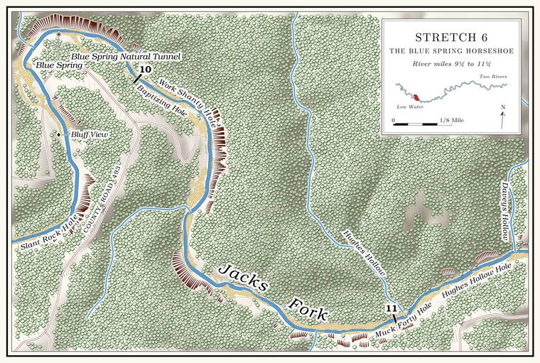
In the 1920s the Salvation Army kept a camp on the leftLewis 1980, PDF p. 23. bankMDC 2003, mile 9.2 (“Salvation Army camp on left”). here, a retreat for its national officers with several buildings. Bluff View, the park’s primitive access on the same bank, may stand on part of the old camp’s ground, though no deed has yet been found to show it. It is reached from the north side of the river by Route O and County Road 437MDC, Jacks Fork Natural Area; NPS 2022a, appendix E.. By river Bluff View lies a quarter of a mile above the Blue Spring campground, and by road it lies on the other side of the river from it (Chapter 8; Part Six).
Below the camp a shallow stretch runs past lily pads on the right toward the old Ford. A place where a road crosses through the water. Many of the river’s fords took the names of the families who lived beside them (Chapter 8). Glossary →, and red streaks of iron oxideLewis 1980, PDF p. 23. in the clay show in the Bluff. A cliff along the river, usually on the outside of a bend, where the river has cut sideways into the hill. In this sense the word was first used in North America (Chapter 2; Chapter 18). Glossary → ahead. In 2017–19 the river near Bluff View and Blue Spring held thirty-eight live Mussel. A freshwater clam that lives half-buried in the riverbed and filters its food from the water. Mussels on the Jacks Fork fell sharply between the surveys of 1982 and 2017–19 (Chapter 16). Glossary → of four kinds, among them the only two live slippershellsMcMurray and Faiman 2023, 15 (table 3). found on the Jacks Fork in 2017–19 (Chapter 16).
The Blue Spring bluff
Caves, pinnacle and tunnel · left bank, above the spring · Plate A4
A short way above Blue Spring the bluff on the left is broken by a cleft, and the cleft has cut a pinnacle of Dolomite. Calcium magnesium carbonate rock, a close relative of limestone, formed from lime mud on the floor of a warm, shallow sea. Nearly every bluff on the Jacks Fork is dolomite (Chapter 1). Glossary → loose from the bluff behind it. Cavers call the pinnacle a rock island. A small saddle behind it is the abandoned course of a hollow that once ran straight into the Jacks Fork. A large Sinkhole. A hollow in the ground where rock below has dissolved or caved in, through which water drains underground; also called a sink, an American use (Chapter 2; Chapter 12). Glossary → opened over the ancestral Blue Spring system and captured that hollow’s waterMSS 1982, 28., and as the ground collapsed the cleft formed and left the pinnacle standing alone. Two small caves pierce it. Flue Cave has a window about Forty. Forty acres, a quarter of a quarter section. A hill farm was often one or two forties (Chapter 5). Glossary → feet above the river and a chimney, the flueMSS 1982, 28; Johnson 2007, 23., that rises to the top of the island. Blue Spring Natural Tunnel runs thirty feet through the pinnacle. It is dry, the remnantMSS 1982, 16. of a larger cave from before the rock around it wore away.
Across the cleft is Hospital Cave, which has three entrances. One is a small opening in a steep Draw. A valley, in the usage of the Eleven Point side of the divide in Howell County (Chapter 18). Glossary →, entered by a wide break in the bluff and hard to findMSS 1982, 32, 34; Lewis 1980, PDF p. 23. without knowing it is there. The cave is 375 feet long. About a hundred feet in, a Flowstone. Calcite laid down in layers by water flowing across a cave floor or wall (Chapter 13). Glossary → squeeze has been polished smooth “from the passage of many bodies,” and a steady wind blows through it. An upper level holds Soda straw. A hollow calcite tube the width of a drop of water, hanging from a cave ceiling. Every stalactite begins as one (Chapter 13). Glossary →. The cave is an older outletMSS 1982, 32, 34. of the water that now comes out at Blue Spring: as the system cut deeper it found a new way out, and Hospital Cave was left dry above it. Its name rests on a Civil War story, the earliest record of which is a hand-lettered sign seen in the 1930sDorrance 1938, 29; see Chapter 13. (Chapter 13).
Loop CaveMSS 1982, 43. opens in the same bluffs and can be seen from the river: a wide entrance about twenty-one feet across and six feet high, divided by a pillar of rock, and so dry inside that it would make “an excellent shelter.” At least fourteen cave entrances open within a quarter of a mile of Blue Spring, and there are probably moreMSS 1982, 34 (the cavers expected more)..
Blue Spring Ford
Ford · above the spring · about mile 9.7
The old Blue Spring cut-off road crossed the river at Blue Spring Ford. By one account it linked the old Lead Mines Trail with the Virginia Warriors Path, the road later known as the Springfield–Van Buren roadLewis 1980, PDF pp. 23–24 (text and map), the only source.. The ford is still driven at Low Water. The local name for the Highway Y bridge over the South Prong, the access beside it and the county’s low-water crossing where the prongs meet, and so for the head of the river (Chapter 8; Chapter 18). Glossary → by high-clearance vehiclesNPS 2022a, 19 and map 10; see Chapter 8. (Chapter 8; Part Six).
Blue Spring
Spring, swimming hole and campground · left bank · mile 9.8 · Plate A4; Figs. 16 and 22
Blue Spring is the landmark of the upper river. The Jacks Fork swings around the bluff here, about 240 feet highthe left-bank face at about miles 9.73 to 9.92, measured on the flood-mapping terrain (Heimann, Atkinson and High 2025; Map 13)., in one of its tightest bends. The spring rises at the foot of the bluff on the outside of the bend, and a large Gravel bar. A bank of chert gravel and sand, usually on the inside of a bend, bare at low water (Chapter 15; Chapter 18). Glossary → fills the inside of the horseshoe, where the campgroundLewis 1980, PDF p. 23; NPS 1977; Fig. 22. sits.
The spring. The water comes out of a cave at the base of the cliff, through a pile of fallen rock that nearly hides it from the river. The cave mouth is about sixty-five feet wide and perhaps twenty-five feet high. Inside the mouth are the broken remains of a concrete dam, which by one account was dated 1938Lewis 1980, PDF p. 23, the only source (“A concrete wall across the entrance is dated 1938”); see Chapter 13. (Chapter 13). Beyond it the Rise pool. A spring pool fed from beneath, where the water wells up from a lower cave passage, as at Blue Spring (Chapter 12; Chapter 13). Glossary → lies deep blue under a ceiling fifteen to eighteen feet above the water, probably twenty feet deep or moreMSS 1982, 16–17; MDC 2003, mile 9.6.. A floater passing one July, probably in 1934, saw “a Pool. A deep, slow stretch of river between riffles (Chapter 16). Glossary → of goblin blue in a v-shaped cleft of the floor” and three blind fishDorrance 1938, 29; see Chapters 9 and 13. in it (Chapters 9 and 13). At low water the spring runs about ten cubic feet a second, close to seven million gallons a day, the second-largestMugel, Richards and Schumacher 2009, 32, 43, 47; see Chapter 12. spring on the Jacks Fork after Alley (Chapter 12).
The spring’s water falls as rain on about fifty-six square miles of upland, much of it to the north-northeast, where no water runs off on the surfaceLewis 1980, PDF p. 23. and the sinkholes clusterMugel, Richards and Schumacher 2009; see Chapter 12. (Chapter 12). A large sink past Bell Flat known as the Drop-In is said to have fallen in early in the twentieth century, and one sinkhole nearer the river has water running through its Bottom. The flat land along a river or creek, built of its deposits and open to its floods. In the 1920s the bottoms near Eminence averaged about a quarter of a mile wide (Chapter 2; Chapter 5). Glossary →. After a gully washer, it is said, cornstalksLewis 1980, PDF p. 23, the only source. have come out of Blue Spring when no corn was growing nearby. Blue Spring’s Recharge area. The land that feeds a spring. It can reach under a ridge into a neighboring watershed, and its underground edge, the groundwater divide, can lie miles from the ridge that divides the streams on the surface (Chapter 12). Glossary → holds more open land and less public landThornberry-Ehrlich 2016, 44; see Chapters 12 and 17. than almost any other spring’s in the riverways (Chapter 17).
The swimming Hole. Any pool deep enough to swim or fish in, named or not, the basic unit of the river in local speech; also “hole of water” (Chapter 18). Glossary →. The pool along the outer bank below the spring has long been a favorite swimming hole, with a big rockLewis 1980, PDF p. 23; Dufur 2013, 19; Fig. 16; see Chapter 19. at its edge for jumping (Fig. 16; Chapter 19). Between the aerial photographs of 2014 and 2020Fig. 22; see Chapter 15. the gravel bars filled the inside of the bend and the deep water narrowed to a channel against the rock and the bluff (Fig. 22). How that happened is the subject of Chapter 15. The narrow run below the spring can be difficultMDC 2003, mile 9.6; see Chapter 20. in a loaded canoe (Chapter 20). From 1991 to 1998 state biologists sampled the crayfish of this stretch every year, and snorkeling around the bluff walls and boulders of the deep pools they often saw big spothanded crayfishDiStefano and others 2003, 346–349, 355; see Chapter 16. where their sampling frames could not reach (Chapter 16). The spothanded crayfish lives only in the Ozarks of Missouri and Arkansas and is one of the larger crayfish of the state, up to about four and a half inches long. It breeds in September and October, the females carry their eggs and then their young through the spring, and most live about two yearsMDC, “Spothanded Crayfish.”. Fish taken from the river at Blue Springs in 1939 and kept at the Field Museum in Chicago number more than two hundred, most of them northern studfish, rosyface and bleeding shiners and Ozark minnows, with a few hornyhead chubs, stonerollers, rainbow and greenside darters, a northern Hog sucker. The northern hog sucker, a bottom fish with a broad head that turns over the stones of the riverbed with its snout; also called hog molly. It is one of the giggers’ main fish, along with their “yellow sucker,” chiefly the golden redhorse (Chapter 19). Glossary → and a blackspotted topminnowField Museum of Natural History, Chicago, fish collection, catalog nos. 60397–60400, 60404, 60405, 60575, 60577, 60645, 60723 and 60724 (L. P. Woods, 1939, “Jack’s Fork of the Current River at Blue Springs”; 229 specimens in these lots, among them 72 Fundulus catenatus, 57 Notropis identified as N. rubrifrons, 56 Dionda [Notropis] nubila and 26 Notropis zonatus; a lot of six catalogued under the old name Ceratichthys tenellus is not named in the text).. Blue Spring is also one of the few springs in the park big enough to change the river’s temperatureWesthoff and Paukert 2014, 6. below it.
The settlement and the campground. Blue Springs was once a small settlement around the spring, in Sections 31 and 32 of Township 28 North, Range 6 West, on the road now numbered OO. On July 4, 1887, the Current River Land and Cattle Company held a large picnic at the spring. The company then ran more than 500 cattle on the range and had lately shipped in sixteen Hereford bulls by railroad from Flint, Michigan, and it hoped to buy Blue Spring, but the purchase fell throughLewis 1980, PDF p. 23, the only source.. By the late 1930s the place was promoted as Blue Spring Park, a tourist development with “a very fine deep spring”O’Brien 1939, 17. as its chief attraction. In 1969 the site was ranked third choice for a Park Service living-history development showing the Ozarks around 1910Brown 1969, 64, 70–72., and nothing came of it.
A large rock house across the river from the spring is said to have been built by a man named Brown, who had patented a process used in oil drilling; around 1980 a park rangerLewis 1980, PDF p. 23, the only source. lived in it. By one account Brown was tied to a tree and left to die in the 1950sLewis 1980, PDF p. 23, the only source (“Brown was tied up to a tree and left to die about 25 years ago,” written in 1980).. By 1977NPS 1977. the park had a campground, picnic area, comfort station and ranger station at Blue Spring. Today a backcountry campground lies inside the horseshoe at the end of County Road 493NPS 2026 (backcountry); NPS 2026 (campsite descriptions); see Chapter 11., which runs down to the river from Highway OO (Chapter 11; Part Six).
The Blue Spring of the Jacks Fork is a different spring from the far larger and deeper Blue Spring on the Current River east of Eminence (Chapter 18).
Work Shanty Hole
Pool · about mile 9.9 · Plate A4
The first hole below Blue Spring, known as Work Shanty Hole, is small and shallow. A good spring enters at the river’s edge below the Brown house, and a slough lies on the left out of sight of the river.
Baptizing Hole
Pool, spring cave and backcountry campsites · about mile 10.0 · Plate A4
Baptizing Hole lies around the bend below Blue Spring, with a high gravel bar on the right, a bluff on the left and several rocks in the pool. It is a good fishing hole. A small spring comes in midway along the left side; in spring it can be seen plainly, and in summer it can be heardLewis 1980, PDF p. 27. but takes some effort to find. The spring comes out of the bluff and cascades over boulders into the river. Baptizing Hole Spring CaveJohnson 2007, 24–25; see Chapter 13. lies in the same stretch (Chapter 13).
A fork of the Blue Spring road leads down to the hole, and a ford here once led across the river to a gravel road to Summersville by way of Routes O and 17Lewis 1980, PDF p. 23, the only source.. The wide, level bank drew church and group picnicsLewis 1980, PDF p. 27.; the gatherings and the namesee Chapter 19. are the subject of Chapter 19. People who know the upper river still call it Baptizing Hole, or Baptism HoleJacks Fork Oral History, records SV-06, SV-12, SV-20, SV-23; USGS GNIS; see Chapter 19.. The park keeps two Backcountry campsite. One of the park’s designated camping places along the river away from the developed campgrounds. On the Jacks Fork they are at Blue Spring, Baptizing Hole, Bachers, Rymers, Bay Creek and Shawnee Creek (Chapter 11; Part Six). Glossary → at the end of a short road, counted with Blue Spring’sNPS 2022a; NPS 2022b; see Chapter 11. (Chapter 11).
Muck Forty Hole and Hughes Hollow
Pool and hollow · about mile 11.0 · Plate A4
A bluff on the right at a bend in the river marks Muck Forty Hole, a good fishing hole, with a small dripping springLewis 1980, PDF p. 27. at its upper end on the right. Hughes Hollow, a small hollow on the federal maps draining about a third of a square mile, comes in from the northUSGS GNIS; drainage traced from USGS 3DEP elevation data (0.8 square kilometers). at about the same point. The pool is named for John “Muck” Reece, who is said to have fallen out of a Johnboat. A long, narrow, flat-bottomed, square-ended boat, poled, paddled or motored. It was the guide boat of the Eminence outfitters and is still the fishing and gigging boat of the river. The word is in print from 1894 (Chapter 9; Chapter 18). Glossary → there one night while Gig, gigging. A gig is a spear of three or four barbed iron tines on a pole as much as fourteen feet long. Gigging is spearing fish with it from a boat in clear, shallow water, chiefly suckers, by night under lights or by day (Chapter 19). Glossary → by pine-knot light and come up claiming he had sunk forty “foot”NPS 1977; Lewis 1980, PDF p. 27 (spelled Reese); see Chapter 18. (Chapter 18). The name Bay Mill Hole has also been placed beside it, at springs on the right bankLewis 1980, PDF p. 29 (map), the only source., perhaps an older name for the pool or for one next to it; no mill has been found to explain the name, and the name is not known locallyJacks Fork Oral History, records SV-06, SV-12, SV-20, SV-23.. The pool’s own name is written both Muck Forty and Muck 40USGS GNIS; NPS 1977..
Hughes Hollow Hole and Daveys Hollow
Pool and hollow · left bank · about miles 11.2 to 11.3 · Plate A5
Below Muck Forty (Reach D) the river runs through Hughes Hollow Hole, known as a long, shallow poolLewis 1980, PDF p. 27, the only source., and swings hard around the mouth of Daveys HollowPlate A5., which comes in on the left on the outside of the bend. The hollow is short, draining less than half a square mileJacks Fork Creek Network 2026 (0.4 square miles)., and is said to carry running waterLewis 1980, PDF p. 27 (“Davey’s Hollow runs water”), the only source.. The federal maps spell it without an apostropheUSGS GNIS; BGN 2016, 50 (federal names policy discourages possessive apostrophes)..