Storys Creek
Creek · left bank · mile 37.6 · Plate A11
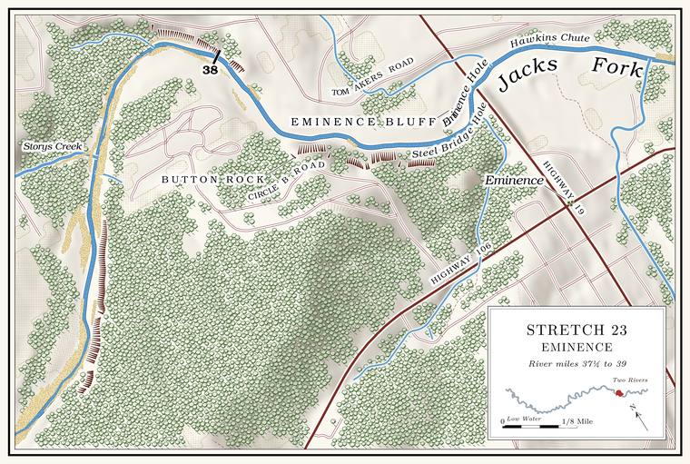
Storys Creek comes in from the north about half a mile below Mahans Creek, “unnoticed,” as one account has it. It drains a little over five square miles down Spurgeon Hollow and Spring Hollow, runs about four miles and flows all year in about its lowest nearly three milesMDC 2001, PDF 28–30 (table Ge03, 4.1 miles total, 2.7 permanent); the creek network traces about 3.4 miles.. An unnamed Branch. A small creek. The sense is American, on record from 1674 (Chapter 18). Glossary → of about two square miles joins it about half a mile upJacks Fork Creek Network 2026 (5.36 square miles, mouth at 37.64, left; the unnamed branch, 2.01 square miles, joining about 900 meters up).. Spurgeon Hollow is a state Natural area. A Missouri tract set aside as one of the best remaining examples of the state’s native communities, to be managed to keep it that way. The Jacks Fork and Barn Hollow natural areas were designated on May 27, 1980 (Chapter 11). Glossary → within the Angeline Conservation Area, and Bush’s skullcap, a plant found only in the OzarksMDC 2018 (Angeline plan; Bush’s skullcap “restricted to the Ozark ecoregion”)., grows there. The creek is said to be named for one of the earliest families in the Ozarks. Two Storys were among the men killed by the Union patrol of 1863see Chapter 6. (Chapter 6), and one family that settled on the creek after the war later moved on to Big ShawneeGibson 2000, 33.. The Storys Creek school now stands at Alleysee Reach H and Chapter 5. (Reach H).
In geologically recent times the Jacks Fork ran up the lower part of this valley and around a small Knob. The old Missouri name for a hill of hard volcanic rock, such as those near Eminence and the mouth (Chapter 1). Glossary → before it cut through the necksee Chapter 2 (Bridge 1930). of the loop (Chapter 2). An outcrop east of the creek gave its name to the Rhyolite. A volcanic rock at least 72 percent silica, the rock of the knobs near Eminence and the mouth. Much of the rhyolite here is tuff (Chapter 1). Glossary → of Storys Creeksee Chapter 1. (Chapter 1).
Button Rock and Circle B
Bluff and pool · left bank (bluff) · about mile 38.0 · Plate A12
Below Storys Creek the next Hole. Any pool deep enough to swim or fish in, named or not, the basic unit of the river in local speech; also “hole of water” (Chapter 18). Glossary → is Button Rock, deep, and long a favorite swimming hole of local people. The Pool. A deep, slow stretch of river between riffles (Chapter 16). Glossary → lies at about mile 38.0, where the river turns from east to southLewis 1980, PDF p. 69 (“Circle B Campground, located across the river”), map PDF p. 66 (Buttin Rock lettered on the left side between the river’s turn below Storys Creek and the bridge); Jacks Fork Oral History, records SV-12 and SV-20 (Button Rock pinned on the river at about miles 38.0 and 38.1) and SV-20 (Circle B pinned on the right bank at about mile 37.95); the river centerline (east-southeast at mile 37.9, south at 38.1); Plate A12 (Circle B Road and the campground inside the loop; a bluff drawn on the left at the outside of the bend, below Storys Creek Road); see Chapter 18 (“the jumping rock across from Circle B”). toward the town, and the rock is on the left, on the outside of the bend, where the Bluff. A cliff along the river, usually on the outside of a bend, where the river has cut sideways into the hill. In this sense the word was first used in North America (Chapter 2; Chapter 18). Glossary → rises about 90 feetmeasured on the flood-mapping terrain (Heimann, Atkinson and High 2025; Map 13), the face on the left at about miles 37.9 to 37.95, at the outside of the bend., across the river from the Circle B campground inside the loop. In town it was the boys’ hole, known to old-timers as the Naked HoleGibson 2000, 41; see Chapter 19. (Chapter 19), and its spelling is still unsettled, Button or Buttinsee Chapter 18. (Chapter 18). By one account William Jones caught a large otterLewis 1980, PDF p. 69, the only source. there in the winter of 1886 (the river’s otters are in Chapter 16), and a car once rolled across the road on the hill above the bluff and plunged down to the edge of the water; the woman driving it survived. The federal maps give the name Buttin Rock to a cliff about 110 feet highmeasured on the flood-mapping terrain (Heimann, Atkinson and High 2025; Map 13), the faces on the right at about miles 38.2 and 38.33 to 38.37. on the right bank about a quarter mile farther downUSGS GNIS (Buttin Rock, cliff, 715135, at about mile 38.3, right bank, about 65 meters from the channel)., on the campground’s side of the river. The state’s Buttin Rock Access, about ten acresMDC 2016 (Buttin Rock Access), 3–4 (9.68 acres; year of initial acquisition 1995; leased to the City of Eminence in January 2012). bought in 1995 and leased to the city of Eminence in 2012, carries the rock’s name.
Asked whether the river had moved between Button Rock and Eminence over the years, an Eminence resident who has done park work answered, “A little wandering from the floods.”Jacks Fork Oral History, record SV-12.
Steel Bridge Hole, Eminence Bluff and the bridge
Pool, bluff and bridge · right bank (bluff) · about miles 38.3 to 38.55 · Plate A12
Below Button Rock the river runs southeast to the Highway 19 bridge at mile 38.55. The pool above the bridge is Steel Bridge Hole, named for the town’s first bridge, and Eminence Bluff stands beside it on the town side. It is a different pool from the Steel Bridge hole at Highway 17, far upriver (Reach C). When the first settlers came, by one account, the river divided here, and a smaller channel ran along the hillside and rejoined the main one a mile below.
By the same account the Eminence Ford was often impassable in high water, and in the summer of 1916 the town set out to get a bridge. Local people gave $3,000, the county court matched it, and the Canton Bridge Company finished a narrow steel-framed bridge in March 1917. It was soon too narrow. Work on a concrete bridge for the new Highway 19 began in February 1934, and it was finished in 1935Lewis 1980, PDF p. 69, the only source.. The present bridge dates from 2002see Chapter 8. (Chapter 8).
The flood of March 1904, by one account the largest anyone remembered, crested at Eminence at 27 feet. In April 2017 the river rose to 27.72, more than a foot and a half above the level at which water stands on the deck of the bridgesee Chapter 14 (the deck is reached at 26 feet). (Chapter 14).
The Eminence riverfront
Town, landings, chute and ford · right bank (town) · about miles 38.55 to 38.9 · Plate A12
Eminence lies on the right bank, the second county seat of that name, moved here from the Current after the warLewis 1980, PDF p. 64; see Chapter 5. (Chapter 5). Below the bridge the river runs southeast past the town through Hawkins Chute, named by one account, like Orchard Bay, Kell Bluff and McCabe Hollow below it, for people who once lived along the river. On the right the state keeps a one-acre public landing by agreement with its owner, the Joshua T. Chilton Memorial Landing, near the junction of Highways 19 and 106MDC, Joshua T. Chilton Memorial Landing., and floaters long took out at the Lions Ball ParkMDC 2003; see Chapter 20., a quarter mile below the bridge (Chapter 20). In 2010 the state’s Conservation Commission approved a contract to build an access at the Eminence city park, with a boat ramp, a canoe ramp, parking and restrooms, and the city was to clear away the park’s bleachers and cook shackMDC 2010 (approved August 20, 2010; the City of Eminence and the department as partners under the department’s Community Assistance Program; estimated cost $353,846.51, three-quarters from the federal Sport Fish Restoration Program).. The Chilton landing is probably that access, on the old ball park’s groundan inference. The release names neither the river nor the landing. The landing is a one-acre area run under a cooperative agreement with an owner the department does not name, on the north side of Highway 106 less than a tenth of a mile east of the Highway 19 junction (MDC, Joshua T. Chilton Memorial Landing); the float guide’s take-out was the ball park a quarter mile below the bridge on the right (MDC 2003); and the release’s bleachers fit a ball park..
From Eminence the guides of the Bales Boating Company took their Johnboat. A long, narrow, flat-bottomed, square-ended boat, poled, paddled or motored. It was the guide boat of the Eminence outfitters and is still the fishing and gigging boat of the river. The word is in print from 1894 (Chapter 9; Chapter 18). Glossary → parties down the Jacks Fork and the Current from 1928see Chapter 9. (Chapter 9), and by one account the company had a large boat ramp on the far side of the river. A generation of Eminence children learned to swim in the river from Luther Rowlett, who called himself a “Retriever”Gibson 2000, 41–42; see Chapter 19. (Chapter 19). The Cross-Country Trail Ride has camped on private land along the river in the gap around the town since 1981see Chapter 11. (Chapter 11).
A creek of about two square miles comes in on the right at about mile 38.9Jacks Fork Creek Network 2026 (2.03 square miles, mouth at 38.89, right, unnamed)., probably the Town Branch that a map of 1980 runs north through the west side of townLewis 1980, PDF p. 66 (map); the match is an inference. to the river. The Eminence Ford crossed below the ball park. On a low hill above the river on the town side lies the Old Eminence Cemetery, on ground Daniel Dye gave in 1873, where by one account two-year-old Cora Dye was the firstLewis 1980, PDF p. 64, the only source. The source lists about eighty family names and puts about two hundred graves there. burial. Cora Bell Dye lived from August 21, 1871, to September 21, 1873, and Daniel E. Dye, her father by one family record, died in 1884Shannon County cemetery readings (Old Eminence Cemetery: Daniel E. Dye, March 18, 1841–March 1, 1884; the parentage is the compiler’s note).. In the winter of 1876Lewis 1980, PDF pp. 69, 68 (the account runs from the foot of one page to the head of the other), the only source., by one account, James Chilton, a son of Joshua Chilton, and Ezekial Miller tried to cross the Ford. A place where a road crosses through the water. Many of the river’s fords took the names of the families who lived beside them (Chapter 8). Glossary → in high water. Chilton’s horse crossed easily. Miller’s threw him into the river, and he was swept downstream and drowned.
Across the river from the old ford lies the Chilton Cemetery, well kept and still in useLewis 1980, PDF p. 71; map PDF p. 66. in 1980. Joshua Chilton’s farm lay across and down the river, by one account (Chapter 6), and in 1939 people remembered a vanished village called ChiltonsvilleO’Brien 1939, 27., named for him, across the river from the town.